- National Register of Historic Places listings in American Samoa
-
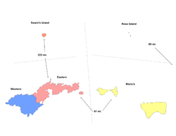
This is a list of the buildings, sites, districts, and objects listed on the National Register of Historic Places in American Samoa. There are currently 24 listed sites spread across the three districts of American Samoa. There are no sites listed on the two unorganized atolls of Swains Island and Rose Atoll.
-
- This National Park Service list is complete through NPS recent listings posted November 10, 2011.[1]
Contents
Numbers of listings
The following are approximate tallies of current listings in American Samoa on the National Register of Historic Places. These counts are based on entries in the National Register Information Database as of April 24, 2008[2] and new weekly listings posted since then on the National Register of Historic Places web site.[3] There are frequent additions to the listings and occasional delistings and the counts here are not official. Also, the counts in this table exclude boundary increase and decrease listings which modify the area covered by an existing property or district and which carry a separate National Register reference number.
District # of Sites 1 Eastern 12 2 Manu'a 1 3 Rose Atoll 0 4 Swains Island 0 5 Western 11 Total: 24 Eastern
[4] Landmark name Image Date listed Location City or town Summary 1 Courthouse of American Samoa February 12, 1974 Near Pago Pago Harbor
14°16′39″S 170°41′24″W / 14.2775°S 170.69°WFagatogo 2 Navy Building 38 March 16, 1972 Pago Pago Harbor
14°16′41″S 170°41′19″W / 14.278056°S 170.688611°WFagatogo 3 Navy Building 43 March 16, 1972 Pago Pago Harbor
14°16′40″S 170°41′16″W / 14.277778°S 170.687778°WFagatogo 4 US Naval Station Tutuila Historic District June 20, 1999 Pago Pago Harbor
14°16′44″S 170°41′09″W / 14.278889°S 170.685833°WFagatogo and Utulei 5 Fagatele Bay Site June 2, 1997 Address Restricted Futiga 6 Satala Cemetery October 19, 2006 American Samoa Highway 001 , west of Satala
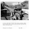
14°16′14″S 170°41′42″W / 14.270556°S 170.695°WLalopua 7 Breakers Point Naval Guns October 18, 1999 Breakers Point
14°17′11″S 170°39′30″W / 14.286389°S 170.658333°WLauli'i 8 Sadie Thompson Building July 2, 2003 Along main road
14°16′35″S 170°41′35″W / 14.276389°S 170.693056°WMalaloa 9 Blunts Point Naval Guns April 26, 1973 Matautu Ridge
14°17′08″S 170°40′36″W / 14.285556°S 170.676667°WPago Pago 10 Government House March 16, 1972 Togotogo Ridge
14°16′38″S 170°40′59″W / 14.277222°S 170.683056°WPago Pago 11 Lau'agae Ridge Quarry March 30, 2000 Address Restricted Tula 12 Tulauta Village June 2, 1997 Address Restricted Tula Manu'a
[4] Landmark name Image Date listed Location City or town Summary 1 Faga Village Site November 23, 2003 Address Restricted Fitiuta Western
[4] Landmark name Image Date listed Location City or town Summary 1 A'a Village (AS-34-33) November 19, 1987 Address Restricted Tapua'ina 2 Aasu April 13, 1972 Near the village of Aasu
14°17′51″S 170°45′30″W / 14.2975°S 170.758333°WAasu 3 Atauloma Girls School March 16, 1972 West edge of Afao
14°19′48″S 170°48′06″W / 14.33°S 170.801667°WAfao 4 Fagalele Boys School March 16, 1972 South of Leone
14°20′31″S 170°47′10″W / 14.341944°S 170.786111°WLeone 5 Michael J. Kirwan Educational Television Center October 23, 2009 American Samoa Highway 118, north side of Utulei
14°16′41″S 170°40′59″W / 14.278056°S 170.683056°WUtulei 6 Governor H. Rex Lee Auditorium November 12, 2010 American Samoa Highway 1, William McKinley Memorial Highway
14°16′44″S 170°40′59″W / 14.278889°S 170.683056°WUtulei 7 Maloata Village June 12, 1997 Address Restricted Tapua'ina 8 Old Vatia November 2, 2006 Above Vatai southwest of American Samoa Highway 015
14°15′13″S 170°41′08″W / 14.253611°S 170.685556°WVatia 9 Site AS-31-72 June 2, 1997 Address Restricted Faleniu 10 Tataga-Matau Fortified Quarry Complex (AS-34-10) November 19, 1987 Address Restricted Leone 11 Tupapa Site October 30, 2009 Address Restricted A'asufou See also
- List of United States National Historic Landmarks in United States commonwealths and territories, associated states, and foreign states
- List of National Natural Landmarks in American Samoa
References
- ^ "National Register of Historic Places: Weekly List Actions". National Park Service, United States Department of the Interior. Retrieved on November 10, 2011.
- ^ "National Register Information System". National Register of Historic Places. National Park Service. 2008-04-24. http://nrhp.focus.nps.gov/natreg/docs/All_Data.html.
- ^ "National Register of Historic Places: Weekly List Actions". National Park Service. http://www.cr.nps.gov/nr/nrlist.htm. Retrieved January 16, 2009.
- ^ Numbers represent an ordering by significant words. Various colorings, defined here, differentiate National Historic Landmark sites and National Register of Historic Places Districts from other NRHP buildings, structures, sites or objects.
U.S. National Register of Historic Places Topics Lists by states Alabama • Alaska • Arizona • Arkansas • California • Colorado • Connecticut • Delaware • Florida • Georgia • Hawaii • Idaho • Illinois • Indiana • Iowa • Kansas • Kentucky • Louisiana • Maine • Maryland • Massachusetts • Michigan • Minnesota • Mississippi • Missouri • Montana • Nebraska • Nevada • New Hampshire • New Jersey • New Mexico • New York • North Carolina • North Dakota • Ohio • Oklahoma • Oregon • Pennsylvania • Rhode Island • South Carolina • South Dakota • Tennessee • Texas • Utah • Vermont • Virginia • Washington • West Virginia • Wisconsin • WyomingLists by territories American Samoa • District of Columbia • Guam • Minor Outlying Islands • Northern Mariana Islands • Puerto Rico • Virgin IslandsLists by associated states Other  Territory of American Samoa
Topics Government - Politics
- Former Governors
- Former Lieutenant Governors
- Elections
- Current Governor
Districts Villages - Aasu
- Afao
- Afono
- Agugulu
- Alao
- Alega
- Alofau
- Amaluia
- 'Amanave
- Amaua
- Amouli
- Anua
- 'Aoa
- Aoloau
- Asili
- Atu'u
- Aua
- 'Au'asi
- Aumi
- Aunu'u
- Auto
- Avaio
- Faga'alu
- Faga'itua
- Fagali'i
- Fagamalo
- Faganeanea
- Fagasa
- Fagatogo
- Failolo
- Faleasao
- Faleniu
- Fatumafuti
- Futiga
- 'Ili'ili
- Lauli'i
- Leloaloa
- Leone
- Leusoali'i
- Luma
- Maia
- Malaeimi
- Malaeloa/Aitulagi
- Malaeloa/Ituau
- Maloata
- Mapusagafou
- Masausi
- Masefau
- Matu'u
- Mesepa
- Nu'uuli
- Nua
- Ofu
- Olosega
- Onenoa
- Pagai
- Pago Pago
- Pava'ia'i
- Poloa
- Sa'ilele
- Se'etaga
- Si'ufaga
- Sili
- Taulaga
- Tafuna
- Taputimu
- Tula
- Utulei
- Utumea East
- Utumea West
- Vailoatai
- Vaitogi
- Vatia
Islands Categories:- National Register of Historic Places in American Samoa
- American Samoa-related lists
-
Wikimedia Foundation. 2010.


