- National Register of Historic Places listings in Gaston County, North Carolina
-

This list includes properties and districts listed on the National Register of Historic Places in Gaston County, North Carolina. Click the "Map of all coordinates" link to the right to view a Google map of all properties and districts with latitude and longitude coordinates in the table below.[1]
-
- This National Park Service list is complete through NPS recent listings posted November 10, 2011.[2]
[3] Landmark name[4] Image Date listed Location City or Town Summary 1 Beam's Shell Service Station and Office, (Former) October 17, 1997 117 N. Mountain St.
35°22′47″N 81°22′48″W / 35.37972°N 81.38°WCherryville 2 Belmont Abbey Cathedral April 11, 1973 On SR 2093
35°15′43″N 81°2′36″W / 35.26194°N 81.04333°WBelmont 3 Belmont Abbey Historic District July 14, 1993 100 Belmont-Mt. Holly Rd. (NC 2093, E side)
35°15′41″N 81°2′34″W / 35.26139°N 81.04278°WBelmont 4 Belmont Historic District December 27, 1996 Roughly bounded by Sacred Heart College campus, RR line, N. and S. Main, Glenway, Bryant Sts., Keener Blvd., Central Ave
35°14′33″N 81°2′22″W / 35.2425°N 81.03944°WBelmont 5 Belmont Hosiery Mill September 16, 2002 608 S. Main St.
35°14′15″N 81°2′54″W / 35.2375°N 81.04833°WBelmont 6 Andrew Carpenter House March 17, 1983 SR 1820
35°23′19″N 81°3′7″W / 35.38861°N 81.05194°WLucia 7 Central School January 9, 2008 317 Washington Ave.
35°17′5″N 81°16′36″W / 35.28472°N 81.27667°WBessemer City 8 Craig Farmstead April 19, 2006 118 Craigland Ln.
35°10′50″N 81°6′26″W / 35.18056°N 81.10722°WGastonia 9 Dallas Graded and High School May 2, 2002 300 W. Church St.
35°18′52″N 81°10′46″W / 35.31444°N 81.17944°WDallas 10 Dallas Historic District July 26, 1973 Bounded by Holland, Main, Gaston and Trade Sts.
35°18′58″N 81°10′35″W / 35.31611°N 81.17639°WDallas 11 Downtown Gastonia Historic District January 6, 2004 Roughly bounded by Main Ave., Broad St., Second Ave., and Chester St.
35°15′41″N 81°10′56″W / 35.26139°N 81.18222°WGastonia 12 First National Bank Building February 20, 1986 168-170 W. Main Ave.
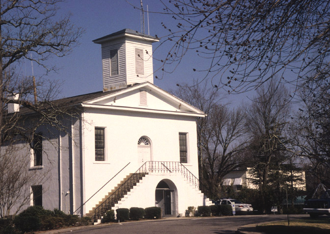
35°15′49″N 81°10′59″W / 35.26361°N 81.18306°WGastonia 13 Gaston County Courthouse 
May 10, 1979 N. York and S. South Sts.
35°15′47″N 81°11′4″W / 35.26306°N 81.18444°WGastonia 14 Gastonia High School March 17, 1983 S. York St.
35°15′10″N 81°11′19″W / 35.25278°N 81.18861°WGastonia 15 Hoyle House October 21, 1993 NC 275 S side, 1400 ft. SW of S. Fork of Catawba R.
35°19′36″N 81°8′17″W / 35.32667°N 81.13806°WDallas 16 Eli Hoyle House December 17, 1998 1111 Dallas-Stanley Hwy
35°19′37″N 81°8′28″W / 35.32694°N 81.14111°WDallas 17 David Jenkins House February 17, 1978 1017 Church St.
35°15′58″N 81°9′59″W / 35.26611°N 81.16639°WGastonia Burned July 1987[5] 18 Loray Mill Historic District October 19, 2001 Roughly bounded by W. Franklin Blvd., S. Vance and S. Trenton Sts., and W. 6th Ave. B; also roughly bounded by S. Vance St., the railroad right-of-way, S. Hill St., and W. Franklin Boulevard
35°15′31″N 81°11′51″W / 35.25861°N 81.1975°WGastonia Second set of boundaries represents a boundary increase of April 5, 2006 19 Mayworth School September 16, 2002 236 Eighth Ave.
35°14′26″N 81°4′32″W / 35.24056°N 81.07556°WCramerton 20 McAdenville Historic District February 5, 2009 100-413 Main St., Elm and Poplar Sts., and cross sts. from I-85 to S. Fork of Catawba River
35°15′38.05″N 81°4′50.35″W / 35.2605694°N 81.0806528°WMcAdenville 21 Mount Holly Cotton Mill August 1, 1996 250 N. Main St.
35°18′2″N 81°0′54″W / 35.30056°N 81.015°WMount Holly 22 Robinson-Gardner Building April 9, 1999 173-175 W. Main Ave.
35°15′49″N 81°11′0″W / 35.26361°N 81.183333°WGastonia 23 St. Joseph's Catholic Church June 7, 1979 Off NC 273
35°20′12″N 81°0′1″W / 35.33667°N 81.00028°WMountain Island 24 Third National Bank Building February 20, 1986 195 W. Main Ave.
35°15′49″N 81°11′2″W / 35.26361°N 81.18389°WGastonia 25 U.S. Post Office, Former November 29, 1995 115 N. Main St.
35°14′37″N 81°2′18″W / 35.24361°N 81.03833°WBelmont 26 William J. Wilson House October 14, 1976 S of Gastonia off SR 1109
35°9′50″N 81°13′13″W / 35.16389°N 81.22028°WGastonia 27 York-Chester Historic District September 1, 2005 Bounded by W. Franklin Blvd., W. Second Ave., South St., W. Tenth Ave., W. Eighth Ave. and S. Clay St.
35°15′19″N 81°11′18″W / 35.25528°N 81.18833°WGastonia See also
- National Register of Historic Places listings in North Carolina
- List of National Historic Landmarks in North Carolina
References
- ^ The latitude and longitude information provided in this table was derived originally from the National Register Information System, which has been found to be fairly accurate for about 99% of listings. For about 1% of NRIS original coordinates, experience has shown that one or both coordinates are typos or otherwise extremely far off; some corrections may have been made. A more subtle problem causes many locations to be off by up to 150 yards, depending on location in the country: most NRIS coordinates were derived from tracing out latitude and longitudes off of USGS topographical quadrant maps created under the North American Datum of 1927, which differs from the current, highly accurate WGS84 GPS system used by Google maps. Chicago is about right, but NRIS longitudes in Washington are higher by about 4.5 seconds, and are lower by about 2.0 seconds in Maine. Latitudes differ by about 1.0 second in Florida. Some locations in this table may have been corrected to current GPS standards.
- ^ "National Register of Historic Places: Weekly List Actions". National Park Service, United States Department of the Interior. Retrieved on November 10, 2011.
- ^ Numbers represent an ordering by significant words. Various colorings, defined here, differentiate National Historic Landmark sites and National Register of Historic Places Districts from other NRHP buildings, structures, sites or objects.
- ^ "National Register Information System". National Register of Historic Places. National Park Service. 2008-04-24. http://nrhp.focus.nps.gov/natreg/docs/All_Data.html.
- ^ "North Carolina Listings in the National Register of Historic Places by County". North Carolina State Historic Preservation Office. 22 October 2008. http://www.hpo.ncdcr.gov/nrlist.htm. Retrieved 14 July 2009.
U.S. National Register of Historic Places Topics Lists by states Alabama • Alaska • Arizona • Arkansas • California • Colorado • Connecticut • Delaware • Florida • Georgia • Hawaii • Idaho • Illinois • Indiana • Iowa • Kansas • Kentucky • Louisiana • Maine • Maryland • Massachusetts • Michigan • Minnesota • Mississippi • Missouri • Montana • Nebraska • Nevada • New Hampshire • New Jersey • New Mexico • New York • North Carolina • North Dakota • Ohio • Oklahoma • Oregon • Pennsylvania • Rhode Island • South Carolina • South Dakota • Tennessee • Texas • Utah • Vermont • Virginia • Washington • West Virginia • Wisconsin • WyomingLists by territories Lists by associated states Other Municipalities and communities of Gaston County, North Carolina Cities Belmont | Bessemer City | Cherryville | Gastonia | Kings Mountain‡ | Lowell | Mount Holly
Towns Cramerton | Dallas | Dellview | High Shoals | McAdenville | Ranlo | Spencer Mountain | Stanley
Townships Unincorporated
communitiesAlexis | Ashebrook Park | Brown Town | Crowders | Hardins | Lucia | Mountain Island | South Gastonia | Springdale | Tryon
Footnotes ‡This populated place also has portions in an adjacent county or counties
Categories:- Gaston County, North Carolina
- National Register of Historic Places in North Carolina
- Buildings and structures in Gaston County, North Carolina
-
Wikimedia Foundation. 2010.