- Mount Holly, North Carolina
-
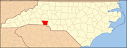
Mount Holly, North Carolina — City — Location of Mount Holly, North Carolina
Coordinates: 35°17′43″N 81°1′10″W / 35.29528°N 81.01944°WCoordinates: 35°17′43″N 81°1′10″W / 35.29528°N 81.01944°W Country  United States
State  North Carolina
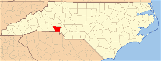
County Gaston Incorporated March 11, 1879 Government – Mayor Robert C. Whitt Area – Total 8.0 sq mi (20.7 km2) – Land 7.8 sq mi (20.1 km2) – Water 0.2 sq mi (0.5 km2) Elevation 640 ft (195 m) Population (2008) – Total 10,081 – Density 1,236.3/sq mi (477.4/km2) Time zone Eastern (EST) (UTC-5) – Summer (DST) EDT (UTC-4) ZIP code 28120 Area code(s) 704 FIPS code 37-44960[1] GNIS feature ID 0990413[2] Mount Holly is a small suburban city in northeastern Gaston County, North Carolina, United States. The city is situated on the western bank of the Catawba River in the Southern Piedmont area of North Carolina, north of Interstate 85, south of North Carolina State Highway 16, and west of Charlotte. The population was 9,618 at the 2000 census.
Historic sites in Mount Holly include St. Joseph's Roman Catholic Church, built in 1843; the Lutheran Church of the Good Shepherd, 1881; the C.E. Hutchinson House and Augusta Rhyne Cannon, 1894; and the Dellinger-Nantz House, 1899.
Contents
Geography
Mount Holly is located at 35°17′43″N 81°1′10″W / 35.29528°N 81.01944°W (35.295178, -81.019319)[3].
According to the United States Census Bureau, the city has a total area of 8.0 square miles (21 km2), of which, 7.8 square miles (20 km2) of it is land and 0.2 square miles (0.52 km2) of it (2.51%) is water.
History
Land grants were first issued in the Mount Holly area by King George II of Great Britain around 1750. In 1754, a land grant was issued to James Kuykendall of Holland in the locale known as Dutchman’s Creek. Later in 1838, a post office in the area was named Woodlawn. In 1875, the name of the town was changed to Mount Holly, after the Mount Holly Cotton Mill that was started that year. The name “Mount Holly” was used in recognition of the famed yarn made at a spinning mill in Mount Holly, New Jersey.
A.P. and D.E. Rhyne and Ambrose Costner originally owned the Mount Holly Cotton Mill. It was the fourth mill to be built in Gaston County and is the oldest surviving mill today. The mill’s success and the prosperity of the area as a whole led local residents to petition the North Carolina General Assembly for incorporation of Mount Holly in 1879.
The first railroad in Gaston County, the Carolina Central Railway, began serving Mount Holly in 1860. The line, which runs parallel with North Carolina State Highway 27, is still in service and operated by CSX. In 1911, construction began on the area’s second railroad known as the Piedmont and Northern Railway. On May 20, 1912 it made its first run from Charlotte to Gastonia.
Electricity became available to homes and businesses around the turn of the twentieth century. The Woodlawn Mill, located on Woodlawn Avenue, was built in 1906 and was the first mill in Gaston County to be served with electricity.[4]
Demographics
As of the census[1] of 2000, there were 9,618 people, 4,028 households, and 2,658 families residing in the city. The population density was 1,236.3 people per square mile (477.3/km²). There were 4,241 housing units at an average density of 545.2 per square mile (210.5/km²). The racial composition of the city was: 86.05% White, 9.58% Black or African American, 2.80% Asian American, 2.12% Hispanic or Latino American, 0.35% Native American, 0.0% Native Hawaiian or Other Pacific Islander, 0.75% some other race, and 1.06% two or more races.
There were 4,028 households out of which 29.5% had children under the age of 18 living with them, 47.1% were married couples living together, 14.0% had a female householder with no husband present, and 34.0% were non-families. 27.9% of all households were made up of individuals and 10.2% had someone living alone who was 65 years of age or older. The average household size was 2.37 and the average family size was 2.89.
In the city the population was spread out with 23.4% under the age of 18, 8.4% from 18 to 24, 34.3% from 25 to 44, 20.6% from 45 to 64, and 13.3% who were 65 years of age or older. The median age was 35 years. For every 100 females there were 92.6 males. For every 100 females age 18 and over, there were 88.4 males.
The median income for a household in the city was $39,459, and the median income for a family was $46,295. Males had a median income of $32,128 versus $23,965 for females. The per capita income for the city was $20,161. About 8.2% of families and 10.8% of the population were below the poverty line, including 16.5% of those under age 18 and 8.5% of those age 65 or over.
Government
The City of Mount Holly has a Council-Manager form of government with a Mayor and six Council Members. The Mayor is elected every two years in November, and the Council Members, elected at-large, serve four-year staggered terms. The City Council appoints a professional City Manager to run the day-to-day operations.
Education
Two elementary schools (Pinewood and Rankin), Mount Holly Middle School, and East Gaston High School are the public schools that serve Mount Holly. All four schools are part of the Gaston County Schools. Because of Mount Holly's geographical location, residents there have access to a number of public and private colleges and universities, including Belmont Abbey College, Gaston College, Central Piedmont Community College, Queens University of Charlotte, Pfeiffer University, Johnson and Wales University, the University of North Carolina at Charlotte, and Johnson C. Smith University.
The Gaston-Lincoln Regional Public Library System, which serves Gaston County and Lincoln County, has a branch in Mount Holly.
Economy
Improvements in the regional transportation network and the economic growth of the Charlotte-Mecklenburg area, and Mount Holly's strategic location between Charlotte and Gastonia, have created conditions for an expanding population in recent years.
The textile industry continues to play a significant role in the Mount Holly area. The Gaston County Economic Development Commission’s current Manufacturing Directory lists nineteen manufacturing firms in the area, ten of which are textile related. The city’s largest textile firm is American & Efird, Inc. (A&E), the world’s second-largest thread maker. The firm was created with a 1952 merger of American Yarn and Processing Company (located in Mount Holly) and the Efird Manufacturing Company (located in Albemarle, North Carolina). American Yarn had its start in 1891 when Charles Egbert Hutchison founded the Nims Manufacturing Company on Dutchman's Creek.[5] With six plants and their corporate offices in Mount Holly, A&E employs over 980 persons, and maintains a strong presence in the community. Other textile businesses in Mount Holly include a large textile dyestuff plant of Swiss firm Clariant and a denim mill of Burlington Industries.
In 1990, the Freightliner Trucks Manufacturing Plant was annexed into the city. Freightliner and its subsidiary businesses have been a significant employer in Mount Holly since 1979.[4]
Since 2007, National Gypsum has operated a wallboard plant in Mount Holly. While gypsum wallboard is typically produced from gypsum rock, the Mount Holly plant uses byproduct gypsum produced by sulfur dioxide scrubbers at four of Duke Power’s coal-fired power plants.[6]
References
- ^ a b "American FactFinder". United States Census Bureau. http://factfinder.census.gov. Retrieved 2008-01-31.
- ^ "US Board on Geographic Names". United States Geological Survey. 2007-10-25. http://geonames.usgs.gov. Retrieved 2008-01-31.
- ^ "US Gazetteer files: 2010, 2000, and 1990". United States Census Bureau. 2011-02-12. http://www.census.gov/geo/www/gazetteer/gazette.html. Retrieved 2011-04-23.
- ^ a b City of Mount Holly Website Retrieved on 2008-07-04.
- ^ American & Efird, Inc. corporate website, retrieved on 2008-07-14.
- ^ "National Gypsum Breaks Ground for Mt. Holly Plant", NGC Press Release, March 27, 2006, retrieved on 2008-07-14
External links
- City of Mount Holly Website
- Mount Holly Community Development Foundation
- Gaston Regional Chamber
- Montcross Area Chamber of Commerce
- Mount Holly Interactive Historical Map
Charlotte Metropolitan Area Counties 
Major city Cities and towns
20k-99kConcord • Gastonia • Huntersville • Kannapolis • Matthews • Monroe • Hickory • Mooresville • Rock Hill • Salisbury • Shelby • StatesvilleCities and towns
5k-20kAlbemarle • Belmont • Bessemer City • Chester • Cherryville • Conover • Cornelius • Davidson • Fort Mill • Indian Trail • Kings Mountain • Lancaster • Lincolnton • Mint Hill • Mount Holly • South Gastonia • Unionville • Wadesboro • Weddington • YorkFootnotes Bold = principal metro cities • Italic = places and counties part of CSAMunicipalities and communities of Gaston County, North Carolina Cities Belmont | Bessemer City | Cherryville | Gastonia | Kings Mountain‡ | Lowell | Mount Holly
Towns Cramerton | Dallas | Dellview | High Shoals | McAdenville | Ranlo | Spencer Mountain | Stanley
Townships Unincorporated
communitiesAlexis | Ashebrook Park | Brown Town | Crowders | Hardins | Lucia | Mountain Island | South Gastonia | Springdale | Tryon
Footnotes ‡This populated place also has portions in an adjacent county or counties
Categories:- Cities in North Carolina
- Populated places in Gaston County, North Carolina
- Populated places established in 1838


Wikimedia Foundation. 2010.