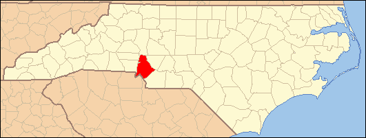
- Mecklenburg County, North Carolina
-
Mecklenburg County, North Carolina 
Flag
Seal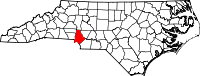
Location in the state of North Carolina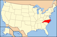
North Carolina's location in the U.S.Founded 1762 Seat Charlotte Area
- Total
- Land
- Water
546 sq mi (1,414 km²)
526 sq mi (1,362 km²)
20 sq mi (52 km²), 3.65%Population
- (2010)
- Density
919,628
1,650/sq mi (637/km²)Website www.charmeck.nc.us Mecklenburg County is a county located in the U.S. state of North Carolina. The population of Mecklenburg County is 919,628 people (as of the 2010 census), making it the both the most populated and densely populated county in North Carolina. Its county seat and largest city is Charlotte.
Contents
History
Mecklenburg County was formed in 1762 from the western part of Anson County. It was named for the German state of Mecklenburg-Strelitz. Due to unsure boundaries, a large part of south and western Mecklenburg County extended into areas that would later form part of the state of South Carolina. In 1768, most of this area (the part of Mecklenburg County west of the Catawba River) was designated Tryon County, North Carolina. Determining the final boundaries of these "western" areas between North and South Carolina would become a decades long process. In 1792 the northeastern part of Mecklenburg County became Cabarrus County. Finally, in 1842 the southeastern part of Mecklenburg County was combined with the western part of Anson County to become Union County.
The Mecklenburg Declaration of Independence was allegedly signed on May 20, 1775; if the document is indeed genuine, Mecklenburg County was the first part of the Thirteen Colonies to declare independence from Great Britain.
Geography
According to the U.S. Census Bureau, the county has a total area of 546 square miles (1,415 km²), of which, 526 square miles (1,363 km²) of it is land and 20 square miles (52 km²) of it (3.65%) is water.
Municipalities
Mecklenburg County contains seven municipalities including the City of Charlotte and the towns of Cornelius, Davidson, and Huntersville (north of Charlotte); and the towns of Matthews, Mint Hill, and Pineville (south and southeast of Charlotte). A small portion of the town of Stallings is also in Mecklenburg County, though most of it is in Union County. Extraterritorial jurisdictions within the county are annexed by municipalities as soon as they reach sufficient concentrations.
Cities and towns
Adjacent counties
- Iredell County, North Carolina - north
- Cabarrus County, North Carolina - northeast
- Union County, North Carolina - southeast
- Lancaster County, South Carolina - south
- York County, South Carolina - southwest
- Gaston County, North Carolina - west
- Catawba County, North Carolina - northwest
- Lincoln County, North Carolina - northwest

Catawba County, Lincoln County Iredell County Cabarrus County Gaston County 
 Mecklenburg County, North Carolina

York County, South Carolina Lancaster County, South Carolina Union County Transportation infrastructure
Air
The county's primary commercial aviation airport is Charlotte Douglas International Airport in Charlotte.
Intercity rail
With twenty-five freight trains a day, Mecklenburg is a freight railroad transportation center, largely due to its place on the NS main line between Washington and Atlanta and the large volumes of freight moving in and out of the county via truck.
Mecklenburg County is served daily by three Amtrak routes.
The Crescent train connects Charlotte with New York, Philadelphia, Baltimore, Washington, Charlottesville, and Greensboro to the north, and Atlanta, Birmingham and New Orleans to the south.
The Carolinian train connects Charlotte with New York, Philadelphia, Baltimore, Washington, Richmond, Raleigh, Durham and Greensboro.
The Piedmont train connects Charlotte with Raleigh, Durham and Greensboro.
The Amtrak station is located at 1914 North Tryon Street.
A new centralized multimodial train station, Gateway Station, has been planned. It is expected to house the future LYNX Purple Line, the new Greyhound bus station, and the Crescent line that passes through Uptown Charlotte.
Mecklenburg County is also the proposed southern terminus for the initial segment of the Southeast High Speed Rail Corridor operating between Charlotte and Washington, D.C. Currently in conceptual design, the SEHSR would eventually run from Washington, D.C. to Macon, Georgia.
Light rail and mass transit
Light rail service in Mecklenburg County is provided by LYNX Rapid Transit Services. Currently a 9.6-mile (15.4 km) line running from Uptown to Pineville, build-out is expected to be complete by 2034.
Charlotte Area Transit System (CATS) bus service serves all of Mecklenburg County, including Charlotte, and the municipalities of Davidson, Huntersville, Cornelius, Matthews, Pineville, and Mint Hill.
The vintage Charlotte Trolley also operates in partnership with CATS.
Freight
Mecklenburg's manufacturing base, its central location on the Eastern Seaboard and the intersection of two major interstates in the county have made it a hub for the trucking industry.
Major roadways
 Interstate 77
 Interstate 85
 Interstate 277
 Interstate 485
 U.S. Highway 21
 U.S. Highway 29
 U.S. Highway 74
 U.S. Highway 521
 North Carolina Highway 16
 North Carolina Highway 24
 North Carolina Highway 27
 North Carolina Highway 49
 North Carolina Highway 51
 North Carolina Highway 73
 North Carolina Highway 115
 Route 4
Economy
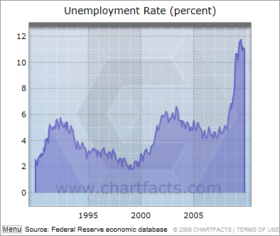
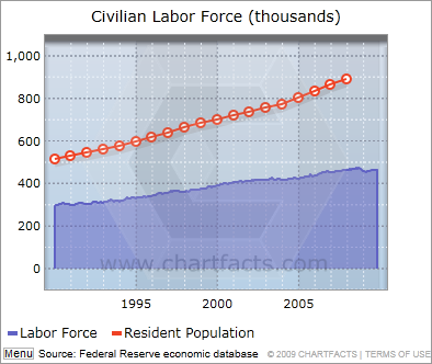
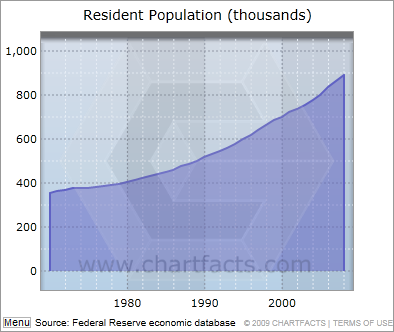
See also: Charlotte Chamber of Commerce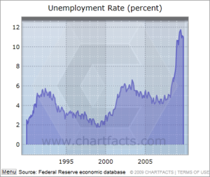 Data represents Jan 1990 to Nov 2009.
 Data represents Jan 1990 to Nov 2009.
The major industries of Mecklenburg County are banking, manufacturing, and professional services, especially those supporting banking and medicine. Mecklenburg County is home to seven Fortune 500 companies,[1] including 9th-ranked Bank of America
Fortune 500 Companies with headquarters in Mecklenburg County
Name Industry Revenue Rank 1. Bank of America Banking $119.2 billion 9 2. Nucor Metals $16.6 billion 151 3. Duke Energy Utilities $13.1 billion 204 4. Sonic Automotive Automotive Retailing $8.8 billion 298 5. Family Dollar Retail $6.8 billion 358 6. Goodrich Aerospace/Defense $6.5 billion 375 7. SPX Electronics $5.1 billion 466 An eighth Fortune 500 company, Wachovia, will retain its headquarters in Mecklenburg while its acquisition by Wells Fargo for $15.1 billion in stock is being completed. The Federal Reserve approved the merger on October 12, 2008.[2]
Mecklenburg County's largest employer is Carolinas Healthcare System, with 26,283 employees, followed closely by Wachovia (20,000) and Bank of America (13,960).[3]
Demographics
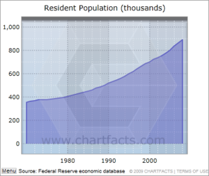 Population grew 2.5% per year from 1970 to 2008.
As of the census[4] of 2000, there were 695,454 people, 273,416 households, and 174,986 families residing in the county. The population density was 1,322 people per square mile (510/km²). There were 292,780 housing units at an average density of 556 per square mile (215/km²). The racial makeup of the county was 64.02% White, 27.87% Black or African American, 0.35% Native American, 3.15% Asian, 0.05% Pacific Islander, 3.01% from other races, and 1.55% from two or more races. 6.45% of the population were Hispanic or Latino of any race .
There were 273,416 households out of which 32.10% had children under the age of 18 living with them, 47.70% were married couples living together, 12.40% had a female householder with no husband present, and 36.00% were non-families. 27.60% of all households were made up of individuals and 5.90% had someone living alone who was 65 years of age or older. The average household size was 2.49 and the average family size was 3.06.
In the county the population was spread out with 25.10% under the age of 18, 9.70% from 18 to 24, 36.40% from 25 to 44, 20.30% from 45 to 64, and 8.60% who were 65 years of age or older. The median age was 33 years. For every 100 females there were 96.50 males. For every 100 females age 18 and over, there were 93.60 males.
The median income for a household in the county was $50,579, and the median income for a family was $60,608. Males had a median income of $40,934 versus $30,100 for females. The per capita income for the county was $27,352. About 6.60% of families and 9.20% of the population were below the poverty line, including 11.50% of those under age 18 and 9.30% of those age 65 or over.
Law, government and politics
Mecklenburg County is a member of the regional Centralina Council of Governments.
The County has two governing bodies: the Mecklenburg Board of County Commissioners (BOCC), and the Charlotte-Mecklenburg Board of Education. Both are nine member boards, with six district representatives and three representatives elected at-large by the entire county. The current chairman of the Mecklenburg BOCC is Jennifer Roberts.
The residents of Mecklenburg County are provided emergency medical service by MEDIC, the Mecklenburg EMS Agency.
Mecklenburg County went for Barack Obama in the 2008 United States Presidential Election by 61.8% to John McCain's 37.4%.[5]
Education and libraries
School system
One common school district, Charlotte-Mecklenburg Schools (CMS), serves the entire county.
Colleges and universities
- University of North Carolina at Charlotte
- Charlotte School of Law
- Davidson College
- King's College
- Queens University of Charlotte
- Central Piedmont Community College
- Johnson & Wales University
- Johnson C. Smith University
Libraries
The Public Library of Charlotte and Mecklenburg County serves residents of Mecklenburg County. Library cards from any branch can be used at all 20 locations. The library has an extensive collection (over 1.5 million items) of reference and popular materials including DVDs, Books on CD, best sellers, downloadable media, and books.
The Billy Graham Library contains the papers and memorabilia related to the career of the well-known 20th century evangelist, Billy Graham.
Sites of interest
Museums and libraries
- ImaginOn
- Discovery Place
- Discovery Place KIDS-Huntersville
- Charlotte Nature Museum
- Carolinas Aviation Museum
- Charlotte Museum of History
- Charlotte Natural History Museum
- Billy Graham Library
- NASCAR Hall of Fame
- Bechtler Museum of Modern Art
- McColl Center for Visual Art
- Mint Museum of Art
- Mint Museum of Modern Art - Opens Fall 2010
- Mint Museum of Craft + Design
- Levine Museum of the New South
- Harvey B. Gantt Center for African-American Arts + Culture
- Public Library of Charlotte and Mecklenburg County
Sports and entertainment
- Carolina Panthers
- Charlotte Bobcats
- Charlotte Checkers
- Charlotte Knights
- Charlotte Motor Speedway
- Bank of America Stadium
- Knights Stadium
- American Legion Memorial Stadium
Music and performing arts venues
- Verizon Wireless Amphitheatre Charlotte
- North Carolina Blumenthal Performing Arts Center
- Knight Theater
- ImaginOn
- Spirit Square
- Uptown Amphitheatre At the NC Music Factory
- The Neighborhood Theatre in NoDa
- Time Warner Cable Arena
- Ovens Auditorium
- Bojangles' Coliseum
Amusement parks
- Carowinds
- Great Wolf Lodge
Other attractions
- Latta Plantation
- Carolina Raptor Center
- U.S. National Whitewater Center
- Lake Norman
- Lake Wylie
- Latta Plantation Nature Preserve
- Concord Mills Mall in Cabarrus County
- Northlake Mall
- SouthPark Mall
- Carolina Place Mall
Notable residents
- Abraham Alexander (1717–1786), on the commission to establish town of Charlotte, North Carolina, North Carolina state legislator[6]
- Evan Shelby Alexander, (1767–1809), born in Mecklenburg County, later United States Congressman from North Carolina[6]
- Nathaniel Alexander, (1756–1808), born in Mecklenburg County, United States Congressman and governor of North Carolina[6]
- Romare Bearden, 20th century African-American artist[7]
- Brigadier General William Lee Davidson,(1746–1781), was a North Carolina militia general during the American Revolutionary War.
- Ric Flair, retired professional wrestler
- Billy Graham, (born 1918), world-famous evangelist who has led religious revivals in many nations around the world. He has also served as a spiritual advisor to many U.S. Presidents.
- Anthony Hamilton, (born 1971), American R&B/soul singer
- James K. Polk, (1795–1849), 11th President of the United States. Polk was born in Mecklenburg County in 1795; his family moved to Tennessee when he was an adolescent.
- Shannon Spake, ESPN NASCAR correspondent
See also
References
- ^ "Fortune 500 Companies". Charlotte Chamber Web Site. http://www.charlottechamber.com/index.php?submenu=fortune_500_members&src=gendocs&link=Fortune500Companies&category=Research. Retrieved 2008-10-21.
- ^ "FRB: Press Release--Approval of proposal by Wells Fargo & Company to acquire Wachovia Corporation". Federal Reserve Board. 2008-10-12. http://www.federalreserve.gov/newsevents/press/orders/20081012a.htm. Retrieved 2008-10-12.
- ^ "Largest Employers". Charlotte Chamber Web Site. http://www.charlottechamber.com/index.php?submenu=largest_employ_members&src=gendocs&link=LargestEmployers&category=Research. Retrieved 2008-10-21.
- ^ "American FactFinder". United States Census Bureau. http://factfinder.census.gov. Retrieved 2008-01-31.
- ^ Uselectionatlas.org
- ^ a b c Who Was Who in America, Historical Volume, 1607-1896. Chicago: Marquis Who's Who. 1963.
- ^ Beardenfoundation.org
External links
- Quickfacts.census.gov
- City of Charlotte and Mecklenburg County Government official website
- Charlotte Mecklenburg County Governance
- Charlotte Mecklenburg County Guide - Mecklenburg Now
- Public Library of Charlotte and Mecklenburg County
- Charlotte Mecklenburg Schools
Municipalities and communities of Mecklenburg County, North Carolina County seat: Charlotte City 
Towns Cornelius | Davidson‡ | Huntersville | Matthews | Midland‡ | Mint Hill‡ | Pineville | Stallings‡ | Weddington‡
Unincorporated
communitiesCaldwell | Hopewell
Footnotes ‡This populated place also has portions in an adjacent county or counties
Charlotte Metropolitan Area Counties 
Major city Cities and towns
20k-99kConcord • Gastonia • Huntersville • Kannapolis • Matthews • Monroe • Hickory • Mooresville • Rock Hill • Salisbury • Shelby • StatesvilleCities and towns
5k-20kAlbemarle • Belmont • Bessemer City • Chester • Cherryville • Conover • Cornelius • Davidson • Fort Mill • Indian Trail • Kings Mountain • Lancaster • Lincolnton • Mint Hill • Mount Holly • South Gastonia • Unionville • Wadesboro • Weddington • YorkFootnotes Bold = principal metro cities • Italic = places and counties part of CSACategories:- North Carolina counties
- Mecklenburg County, North Carolina
- States and territories established in 1762


Wikimedia Foundation. 2010.