- U.S. Route 74
-
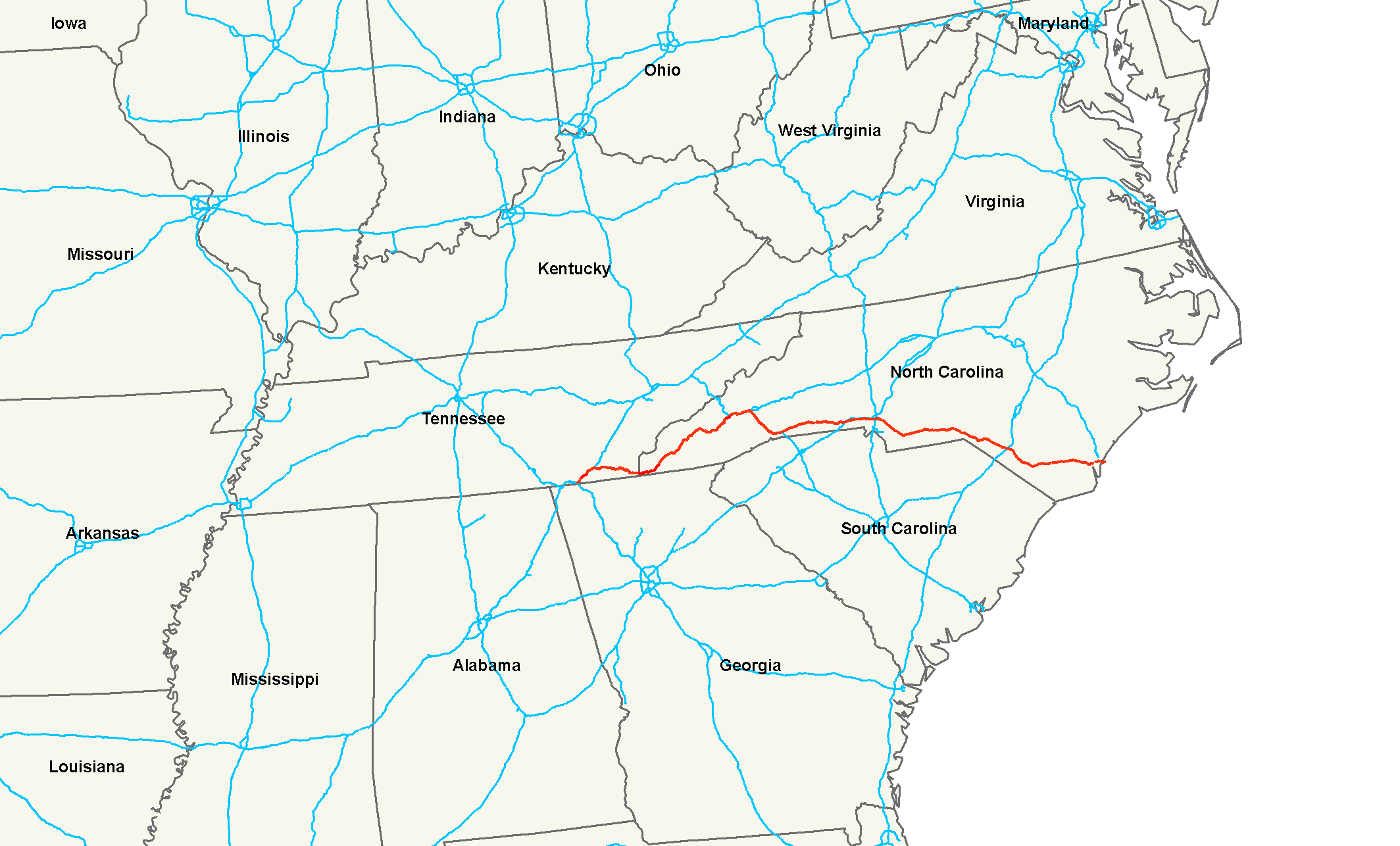
U.S. Route 74
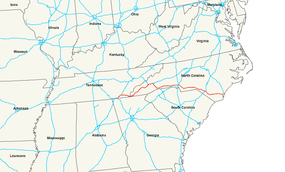
Route information Length: 497 mi[2][1] (800 km) Existed: 1927[1] – present Major junctions West end:  I-75 at Cleveland, TN
 US 23 / US 441 at Dillsboro, NC
 I-40 near Asheville, NC
 I-26 at Columbus, NC
 I-85 at Kings Mountain, NC

 I-77 / US 21 at Charlotte, NC
 US 1 in Rockingham, NC


 US 15 / US 401 / US 501 at Laurinburg, NC


 I-74 / I-95 / US 301 at Lumberton, NC
 US 701 at Whiteville, NC
 US 17 at Wilmington, NC
East end: Wrightsville Beach, NC Highway system United States Numbered Highways
List • Bannered • Divided • Replaced
←  SR-73
SR-73TN I-75 →←  NC 73
NC 73NC NC 75  →
→U.S. Route 74 is an east–west United States highway that runs for 497 miles (800 km) from Cleveland, Tennessee to Wrightsville Beach, North Carolina.
Contents
Route description
Tennessee
Established in 1987, US-74 western terminus is exit 20 on I-75 in Cleveland. After 1.5 miles (2.4 km), it is overlapped with US-64 for the remaining 42.3 miles (68.1 km) in Tennessee before entering North Carolina (a total of 43.8 miles (70.5 km)).
Signage for US-74 is poor, as it appears more as an after-thought by TDOT. Most highways that cross US-74 will typically only mention US-64 instead; I-75 even ignores US-74 at its terminus, showing instead a connector to US-64. Unconfirmed if US-74 actually continues as a hidden highway west into Chattanooga and ends at I-24/I-75 interchange.
North Carolina
From the Tennessee state line, US 74 traverses across the southern portion of the state, connecting the cities Asheville, Charlotte, and Wilmington, for a total of 451.8 miles (727.1 km).
Western North Carolina
Established in 1987, US 74 was overlapped on pre-existing highways in the region, specifically the: Appalachian Highway (at-grade expressway, except in the Nantahala Gorge) and the Great Smoky Mountains Expressway (controlled-access freeway, which is broken in three sections along the route). The alternating named highway (depending on grade of road) is considered the commercial back-bone and main truck route of Western North Carolina, connecting the cities of Murphy, Andrews, Bryson City, Cherokee, Sylva, and Waynesville. In or around October, the fall colors create an influx of more tourists in the region. In the winter months, the highway is the first to be salted and plowed; however, both the Nantahala Gorge and Balsam Gap tend to get the most snow and/or ice in the region and should be traveled with care.
At mile marker 108, it begins a 19 miles (31 km) overlap with I-40 till Asheville, where it switches partners with I-26 for an additional 36 miles (58 km) of interstate overlap. At Columbus, it separates with I-26, going east, on the Solon David Smart Memorial Highway, towards Shelby.
Metrolina
In Cleveland County, the freeway downgrades to an expressway. US 74 then goes through the city of Shelby, notorious for its traffic tie-ups; and then nearby Kings Mountain, where it returns to freeway grade. After the Interstate 85 weave intersection, it downgrades again to an expressway through the city and downtown area of Gastonia. Entering Mecklenburg County, the highway becomes known as Wilkinson Boulevard; in Uptown Charlotte, it becomes the John Belk Freeway; then followed promptly as Independence Freeway/Boulevard before exiting Mecklenburg county. Between Matthews and Monroe, the highway is known for its chronic rush hour traffic tie-ups; this is where the proposed new toll road, the Monroe Bypass, will be established to alleviate the traffic problem. After the city of Monroe (more specifically after US 601), the highway quickly becomes less stressful; the cities of Wingate and Wadesboro follow before crossing the Pee Dee River.
Sandhills
In Rockingham, US 74 meets up with Future I-74 at mile marker 311; it will continue along the same route till Bolton. Majority of the highway in the Sandhills region is at freeway grade; however only the American Indian Highway, a 19 miles (31 km) section, is at Interstate standards allowing a true concurrency I-74. This is one of only two instances (along with proposed I-41 in Wisconsin) of similarly-numbered U.S. and Interstate routes being designated on the same road.
Cape Fear
After Lumberton, the US 74 overlaps with US 76, which will continue mostly together till Wrightsville Beach, where US 74 will dead-end north and US 76 will dead-end south. The highway connects the cities and towns of Whiteville, Lake Waccamaw, and Wilmington. The road through the Cape Fear region is flat, surrounded by parts of the Green Swamp.
Scenic byways
Nantahala Byway is an 43-mile (69 km) byway from Marble to Whittier; it is known for its scenic views of the Nantahala Gorge, The Great Smoky Mountain Railroad, and the whitewater rafting on the Nantahala River . US 74 overlaps 38 miles (61 km) of the byway from Marble to Bryson City. The byway also overlaps with US 19 and US 129.[3]
Junction list
Tennessee
North Carolina
County Location Mile[2] Exit Destinations Notes Cherokee 12  NC 294 – Suit, Hiwassee Dam
14  NC 60 – Culberson
15 
 US 19 south (Blairsville Highway) / US 129 south – Blairsville
South end of US 19/129 overlap Murphy 20 
US 19 Bus. north (Hiwassee Street)20.5  US 64 east – Hayesville, Franklin
East end of US 64 overlap 23
US 19 Bus. south (Pleasant Valley Road)Marble 29  NC 141 south
Andrews 34
US 19 Bus. north (Main Street)
 Airport Road – Western Carolina Regional Airport
37
US 19 Bus. south (Main Street)Graham Topton 44 US 129 north (Tallulah Road) – RobbinsvilleNorth end of US 129 overlap Swain Almond 59  NC 28 north (Mtn. Waters Scenic Byway) – Robbinsville, Fontana
North end of NC 28 overlap; also to Fontana Dam Lauada 62 NC 28 south – FranklinSouth end of NC 28 overlap 64 64 US 19 north (Alarka Road)North end of US 19 overlap; begin of Great Smoky Mountains Expressway Bryson City 67 67 Bryson City, Great Smoky Mtns Nat'l Park 69 69 Hyatt Creek Road – Ela Whittler 72 72 Whittler Jackson 74 74 US 441 north – CherokeeNorth end of US 441 overlap 81 81 US 23 south / US 441 south – Dillsboro, Franklin, AtlantaSouth end of US 19/441 overlap, Eastbound listed as exit 81A
Eastbound exit 81B has no signage, goes to Rufus Robinson RoadSylva 83 83 Sylva Grindstaff Cove Road 85 85 
 US 23 Bus. to NC 107 – Sylva, Western Carolina University
Haywood Balsam 94 Blue Ridge Parkway Waynesville 98 98
US 23 Bus. – Waynesville100 100 Hazelwood Avenue 102 102  US 276 – Waynesville, Brevard
Lake Junaluska 103 103 US 19 south – Maggie ValleySouth end of US 19 overlap 104 104
 US 23 Bus. / NC 209 – Lake Junaluska, Waynesville, Hot Springs
105 105 West Jones Cove Clyde 106 106 US 19 north / US 23 north – ClydeNorth end of US 19/23 overlap 107 107 East Jones Cove 108 108 I-40 west – KnoxvilleWest end of I-40 overlap; end of Great Smoky Mountains Expressway US 74 overlaps with Interstate 40 (exits 27 to 46A) and Interstate 26 (exits 31B to 67) Polk Columbus 161 161  I-26 east to NC 108 – Tryon, Spartanburg
East end of I-26 overlap 163 163 NC 108 – Columbus, Mill Spring167 167  NC 9 – Mill Spring, Lake Lure, Chimney Rock, New Prospect
170 170 Pea Ridge Road Rutherford 173 173 Union Road 178 178 

 US 221 / US 74 Bus. – Rutherfordton, Spartanburg
Forest City 181 181  US 74A to US 64 – Spindale
182 182 


US 221 Alt. – Forest City184 184 Old Caroleen Road 187 187 Henrietta, Caroleen, Ellenboro 189 189  NC 120
Cleveland Mooresboro 191
US 74 Bus. west – Forest CityShelby 198  NC 226 north (Polkville Road) – Polkville, Marion
North end of NC 226 overlap 199
US 74 Bus. east (Marion Street)201 
 To NC 18 to NC 150 – Gaffney
Signage only shows TO NC 18, ignoring NC 150 overlap 201.5 NC 226 south (Earl Road) – GroverSouth end of NC 226 overlap 203  NC 180 (Post Road) – Gaffney
204
US 74 Bus. west (Marion Street)Kings Mountain 209
US 74 Bus. east (Shelby Road) – Moss Lake212 Oak Grove Road 213  NC 216 (Piedmont Avenue) – Kings Mountain, Cherryville
214  NC 161 (Cleveland Avenue) – Bessemer City
Gaston 215
US 74 Bus. west (King Street) – Kings Mountain
 I-85 / US 29 south – Spartanburg
Westbound entrance and eastbound exit
South end of US 29 overlap; eastbound US 74 goes between I-85 for almost a mileGastonia 220  NC 274 north (Bessemer City Road) – Bessemer City
North end of NC 274 overlap 222  US 321 (Chester Street/York Street)
North-south US 321 divided on one-way streets 223 NC 274 south (Broad Street)South end of NC 274 overlap; train tracks in medium of road 224  NC 279 (New Hope Road)
224.5 Aberdeen Boulevard – To Cox Road/Shopping Mall Belmont 231  NC 7 (Main Street)
To Belmont Abbey College 231.5  NC 273 (Park Street) – Mount Holly
232 NC 7 west (Catawba Street)Mecklenburg Charlotte 235  I-485 – Pineville, Huntersville
236 Little Rock Road – Charlotte/Douglas Int'l Airport237 Boyer Street/Billy Graham Pkwy – Charlotte/Douglas Int'l Airport239.5 US 29 north (Morehead Street)North end of US 29 overlap 240 I-77 / US 21 – Statesville, ColumbiaSouth end of I-277 overlap US 74 overlaps with Interstate 277 (exits 1A to 2B) 242 242 
 I-277 / NC 16 north (Brookshire Freeway)
North end of I-277/NC 16 overlap 243 243  NC 27 west (Charlottetowne Avenue)
Westbound exit and eastbound entrance, west end of NC 27 overlap
This was originally a westward extension of Independence Boulevard until June 18, 2007244 244 Briar Creek Road – Bojangles' Coliseum Exit also for Ovens Auditorium 245 245A Wendover Road 245 245B Eastway Drive 246 246 NC 27 east (Albemarle Road)Eastbound entrance and westbound exit, east end of NC 27 overlap Matthews 252  NC 51 (Matthews Township Parkway) – Matthews, Mint Hill
254 I-485 – Pineville, ConcordUnion Monroe 265 Concord Avenue 265.5 
 US 601 north / NC 200 south (Skyway Drive) – Fairview, Mineral Springs
North and South end of US 601 and NC 200 overlap 266 NC 200 north – UnionvilleNorth end of NC 200 overlap 268 US 601 south – PagelandSouth end of US 601 overlap Marshville 276  NC 205 (Elm Street/White Street) – New Salem
Brief NC 205 overlap Anson Polkton 285  NC 218 west (Williams Street) – New Salem, Mint Hill
Wadesboro 285 
 US 52 north / NC 742 north – Albemarle, Anson County Airport
North end of US 52 and NC 742 overlap 293  NC 109 (Greene Street) / NC 742 south – Mount Gilead
South end of NC 742 overlap 295 US 52 south – CherawSouth end of US 52 overlap 304  NC 145 south – Morven, Chesterfield
Richmond 306 306
US 74 Bus. – Rockingham308 308 Galestown Rd. – Cordova 311 311  US 1 to US 220 – Rockingham, Southern Pines, Cheraw
West end of Future I-74 overlap 316 316  NC 177 – Hamlet
319 319  NC 38 east – Bennettsville
320 320  NC 381 – Hamlet, Gibson
321 321
US 74 Bus. – HamletWestbound exit and eastbound entrance Scotland Laurel Hill 329  NC 144 east (Morgan Street)
US 74 overlaps with Interstate 74 (exits 181 to 213) Robeson 373  NC 72 west (Wilmington Highway) – Lumberton, Red Springs
374  NC 130 west – Fairmont
West end of NC 130 overlap Columbus Evergreen 380  NC 242 (Haynes Lennon Highway) – Bladenboro
Chadbourn 385
 US 74 Bus. east / NC 130 east / NC 410 – Chadbourn, Bladenboro
East end of NC 130 overlap 387  US 76 west – Chadbourn, Fair Bluff
Westbound entrance and eastbound exit, west end of US 76 overlap 390 Union Valley Road – Union Valley Whiteville 392 US 701 – Whiteville, Clarkton395
US 74 Bus. west / US 76 Bus. west – WhitevilleAlso to NC 214 Bolton 410  NC 211 – Clarkton, Bolton, Supply
413  NC 214 west – Bolton
Western terminus of NC 214 Freeman 417  NC 11 north – Sandyfield
Southern terminus of NC 11 Delco 422  NC 87 north – Riegelwood
North end of NC 87 overlap Maco 426 NC 87 south – BishopSouth end of NC 87 overlap Brunswick Leland 421 Lanvale Road – Leland 435 US 17 south – Town Creek, WinnabowSouth end of US 17 overlap 436  NC 133 south – Belville, Southport
South end of NC 133 overlap 438
 US 17 Bus. south / US 76 east / US 421 – Wilmington, Carolina Beach
North and Southeast end of US 17 Bus., 76 and 421 overlap New Hanover Wilmington 439 US 17 / US 421 north – Clinton, HampsteadNorth end of US 17 and 421 overlap 440 3rd Street – Downtown Wilmington 441 McRae Street Eastbound exit only 441.5 NC 133 north – HightsvilleNorth end of NC 133 overlap 442 23rd Street/Airport Boulevard – Wilmington International Airport444 Kerr Avenue 445 
 To I-40 / US 117 / NC 132 – Carolina Beach, Castle Hayne, Raleigh
446
US 17 Bus. (Market Street) – Wilmington, Ogden448 US 76 west (Military Cutoff Road) – WilmingtonWest end of US 76 overlap Wrightsville Beach 449 US 76 east (Causeway Drive)East end of US 76 overlap 450 Lumina Avenue End of US 74 is 1.8 miles (2.9 km) from intersection, north on Lumina Avenue 1.000 mi = 1.609 km; 1.000 km = 0.621 mi
Concurrency terminus • Closed/Former • Incomplete access • UnopenedHistory
"American Indian Highway" controversy
In Robeson County, the highway is designated "American Indian Highway", a name that was the brain child of Robert M. Chavis, the Wolfclan chief of the NC Tuscarora; Cherokee Indians of Robeson County, and Nottoway Nation, whom authored the name in the late 1990s. American Indian people of Robeson county NC had attempted to remove Andrew Jackson's name from the highway for some sixty years. Knowing that the new HWY 74 was to come Robert M. Chavis started a campaign to change the name to American Indian Highway. Mr. Chavis did this in honor of all the Indian people that had lost their lives along the Trail of Tears during the Indian Removal Act of the 1830s that was authored by Andrew Jackson. Robert M. Chavis was cited in many newspapers across North Carolina stating that the name should be changed, because that name on this section of road was tantamount to having a major road named Adolf Hitler that ran across a Jewish State or county. Robert Chavis with the help of the Tuscarora East of the Mountains obtained the information on how to attempt the name change from Rep. Ronnie Sutton and the NC-DOT. Then Robert Chavis presented orally the concerns, reasons for the name change to all the cities of Robeson county and the Robeson County Commissioners. Mr. Chavis' presentations convinced all these governmental bodies to sign on to the name change. Once he obtained approval from these entities he presented the name change to the NC-DOT. Rep. Ronnie Sutton supported the name change at the state level and the name change was approved by the NC-DOT. The new signs of American Indian Highway were placed on the new sections of I-74 once the highway construction was completed.[4] in recognition of Jackson's anti-Indian policies.[5]
Extension into Tennessee
In 1987, several highways west of Asheville were given the designation U.S. 74. This served several purposes: one number, rather than several, designated the main highway between Asheville and the Tennessee line. The other was to eliminate the designation of U.S. 19-A, used on the original U.S. 19 since 1948, when a road through Maggie Valley was improved and designated as U.S. 19. A bypass of Waynesville was finished in the 1960s, along with bypasses of Sylva and Dillsboro and of Bryson City in the 1970s. All were given the name U.S. 19A until the U.S. 74 renaming in 1987.[6]
Independence Boulevard
Independence Boulevard and Independence Expressway are two major interconnected roads in Mecklenburg County, North Carolina that carry US 74. Originally constructed in the 1940s and early 1950s, Independence Boulevard was the city of Charlotte's first expressway. The road has undergone numerous realignments, extensions, upgrades, truncations, and renamings since the mid-twentieth century.
Ben Douglas, former mayor of Charlotte and member of the North Carolina State Highway Commission, helped lead the push for the urban highway project in the 1940s that would become Independence Boulevard. In 1946, Charlotte voters passed a referendum in favor of a $200,000 bond issue to fund the project; this was coupled with over $2 million in federal funding. The expressway was to be named after Independence Park that was largely demolished to make way for the road; the name suggestion was coined by City Clerk Lillian Hoffman on May 4, 1949 after a previous suggestion naming it after the current mayor, Herbert Baxter, was rejected. Construction commenced in the late 1940s and the new expressway which traversed east–west along the southern part of the city opened in two parts; the first opened to traffic in 1949 and the other opened in 1950. US 74 and NC 27 were subsequently shifted from their central business district alignments to the new expressway.
Major changes to Independence Boulevard occurred in the 1980s. A portion of West Independence Boulevard was converted from expressway to limited-access freeway and made a part of the John Belk Freeway and Interstate 277. The portion west of Interstate 77 was renamed Wilkinson Boulevard. A new intersection with I-277 was constructed and the connecting freeway along with the updated portion of East Independence Boulevard was given the name Independence Freeway; US 74 was shifted to this new alignment. After the massive transportation revamp, a few disconnected segments of the original Independence Boulevard remained. These segments were later reorganized and given the names Carson Boulevard, Stonewall Street, and South Independence Boulevard; the latter was downgraded to a surface street and renamed Charlottetown Avenue in 2007 to prevent confusion with the unconnected East Independence Boulevard.
The freeway and bus lanes of Independence Freeway were extended to Albemarle Road in 2005. The limited-access road extension has caused numerous businesses along the corridor to leave the area and vacate their commercial real estate, resulting in brownfield land.
Future
In addition to the expected concurrency with I-74 east of Rockingham, another controlled-access facility, called the Monroe Connector / Bypass, is also in the plans for U.S. 74. The bypass will run from Charlotte to Marshville, North Carolina, relieving traffic on the current alignment between these two cities. Several environmental issues have delayed this project for a number of years and it is currently being re-studied by the North Carolina Turnpike Authority.[7]
There are also plans to build three new interchanges on Independence Boulevard. They will be located at Sharon-Amity Road, Idlewild Road and Conference Drive. Currently, all three junctions are signalized at-grade intersections.[8]
A bypass of Shelby, North Carolina (west of Charlotte) is also planned.[9] Once completed, U.S. 74 will be a continuous freeway from Waynesville, North Carolina (west of Asheville) to Kings Mountain and points east, pending the completion of those projects.
A 4-Lane Expressway with a tunnel and viaduct running from Almond in Swain County to Andrews, NC around Robbinsville is in the planning stages. The road presently runs through Nantahala Gorge and is a bottleneck with two lanes, as on each end of the Gorge is a 4-lane highway presently, and the new highway would clear the bottleneck and make Robbinsville more accessible to the outside world and Cherokee County to the rest of North Carolina. This plan has been marked with controversy, however, as it would disrupt the environment, spoil some views, and be the first four lane highway in Graham County.
Alternate names
Though the highway is commonly known as "US 74" throughout the state of North Carolina and "US-64" (or ignored) in Tennessee, the highway does have other known names it uses locally in areas.
- American Indian Highway - Official name of the 19 miles (31 km) section of I-74/US 74 in Robeson County (mile marker 191-213). It is named to honor the large American Indian population in Robeson County.[10]
- Andrew Jackson Highway - Official name of US 74 throughout the state of North Carolina, except in Robeson County (it is still named along the old sections of US 74 now called US 74 Business and Alternate). It was established to honor of the seventh President of the United States, Andrew Jackson.
- Appalachian Highway - Road name of the expressway sections in Cherokee, Graham, Swain, Jackson, and Haywood counties.
- Causeway Drive - Road name on Harbor Island in Wrightsville Beach.
- Eastwood Road - Road name in Wilmington.
- Great Smoky Mountains Expressway - Road name of the freeway sections in Swain, Jackson, and Haywood counties.
- Independence Boulevard/Freeway - Road name east of Uptown to Mecklenburg county line, named after nearby Independence Park.
- John Belk Freeway - Road name of freeway in Uptown Charlotte, named after John M. Belk, who was mayor of Charlotte from 1969-1977.
- Martin Luther King Jr. Parkway - Road name in Wilmington.
- Laurinburg Bypass - Road name of freeway that bypasses around Laurinburg.
- Lumina Avenue - Road name in Wrightsville Beach.
- Salisbury Street - Road name connecting Causeway Drive and Lumina Avenue in Wrightsville Beach.
- Solon David Smart Memorial Highway - Road name in Polk and Rutherford Counties.
- Wilkinson Boulevard - Road name west of Uptown to Mecklenburg county line.
In popular culture
U.S. Route 74 was the inspiration for the song "Distraction #74," by the North Carolina band The Avett Brothers.[citation needed]
Photo gallery
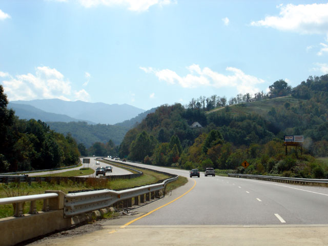
-
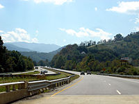
Great Smoky Mountains Expressway through Waynesville (2006-10-01).
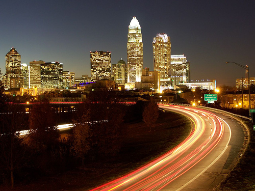
-
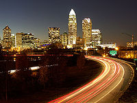
The Charlotte Skyline from Independence Freeway (2008-07-01).
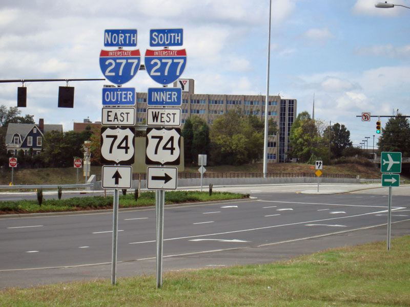
-
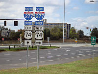
I-277/US 74 directional signs at Stonewall Street, Charlotte (2009-10-18).
See also
- Bannered routes of U.S. Route 74
- Broad River
- Cape Fear River
- Catawba River
- Crowders Mountain State Park
- French Broad River
- Hiwassee River
- Lake Wylie
References
- ^ a b US Highways from US 1 to US 830 Robert V. Droz
- ^ a b Google, Inc. Google Maps – US 74 (Map). Cartography by Google, Inc. http://maps.google.com/maps?f=d&source=s_d&saddr=US-74+W%2FUS-74+Scenic+W&daddr=35.2624,-81.16504+to:35.24866,-81.02087+to:35.23387,-80.93373+to:34.2581172,-77.9360409+to:Unknown+road&hl=en&geocode=FehhGAIdKMrv-g%3BFcAPGgIdEIUp-ynDHjT6CsBWiDE_uUyYtIhxAg%3BFRTaGQIdOrgr-ykVDtUecr1WiDHoW1q-sJHoAg%3BFU6gGQIdngwt-yl3eJFVeqJWiDEjLIcA3OrEIg%3BFcW8CgIdWMpa-ynlBw9J-h-qiTHNFr5NzTU5Kg%3BFWRoCgIdhD1d-w&mra=dpe&mrcr=0&mrsp=4&sz=13&via=1,2,3,4&sll=34.254946,-77.911606&sspn=0.105988,0.222988&ie=UTF8&ll=34.551811,-80.650635&spn=6.756792,14.27124&z=7. Retrieved 2011-02-01.
- ^ "NCDOT: Scenic Byways". http://www.ncdot.org/travel/scenic/. Retrieved 2011-03-01.
- ^ "I-74 North Carolina exit list". http://www.duke.edu/~rmalme/i74exit.html. Retrieved 2009-11-19.
- ^ "Naming of the American Indian Highway". lumbeetribe.com. http://www.lumbeetribe.com/Press%20Room/Archived%20Stories/2008/American%20Indian%20Highway.html. Retrieved 2009-11-19.
- ^ "NCRoads.com: U.S. 19". http://members.cox.net/ncroads/ushwys/us019.html#19A. Retrieved 2009-11-19.
- ^ Monroe Bypass Project
- ^ Part of Independence to be Reworked — From Charlotte.com
- ^ R-2707 - U.S. 74 Shelby Bypass Project Breakdown Map - NCDOT
- ^ "Media Advisory: I-74 "The American Indian Highway" Naming Ceremony". https://apps.dot.state.nc.us/pio/releases/details.aspx?r=4259. Retrieved 2010-12-31.
External links
 Main U.S. Routes
1 2 3 4 5 6 7 8 9 10 11 12 13 14 15 16 17 18 19 20 21 22 23 24 25 26 27 28 29 30 31 32 33 34 35 36 37 38 40 41 42 43 44 45 46 48 49 50 51 52 53 54 55 56 57 58 59 60 61 62 63 64 65 66 67 68 69 70 71 72 73 74 75 76 77 78 79 80 81 82 83 84 85 87 89 90 91 92 93 94 95 96 97 98 99 101 163 400 412 425 Lists U.S. Routes • Bannered • Divided • Bypassed Major highways of Metro Charlotte Interstates 
Interstate 77 
Brookshire/John Belk 
Interstate 85 
I-485 (Outerbelt) Major U.S. Highways 
US 29 (Wilkinson/North Tryon) 
US 74 (Wilkinson/Independence) 
US 321 Major North Carolina State/Charlotte City Highways 
Brookshire/Providence 
W.T. Harris Boulevard 
Albemarle Road 
Billy Graham Categories:- U.S. Highway System
- U.S. Highways in North Carolina
- U.S. Highways in Tennessee
- Polk County, Tennessee
- Transportation in Cherokee County, North Carolina
- Transportation in Graham County, North Carolina
- Transportation in Swain County, North Carolina
- Transportation in Jackson County, North Carolina
- Transportation in Haywood County, North Carolina
- Transportation in Buncombe County, North Carolina
- Transportation in Polk County, North Carolina
- Transportation in Rutherford County, North Carolina
- Transportation in Cleveland County, North Carolina
- Transportation in Gaston County, North Carolina
- Transportation in Mecklenburg County, North Carolina
- Transportation in Union County, North Carolina
- Transportation in Anson County, North Carolina
- Transportation in Richmond County, North Carolina
- Transportation in Scotland County, North Carolina
- Transportation in Robeson County, North Carolina
- Transportation in Columbus County, North Carolina
- Transportation in Brunswick County, North Carolina
- Transportation in New Hanover County, North Carolina
- Transportation in Charlotte, North Carolina

Wikimedia Foundation. 2010.