- U.S. Route 58
Infobox road
state=VA
type=US
route=58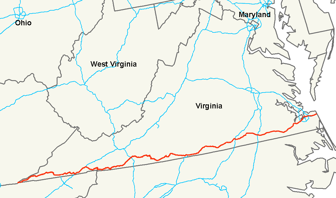
length_mi=508
length_km=
length_round=0
length_ref= [http://www.us-highways.com/us1830.htm US Highways from US 1 to US 830] Robert V. Droz]
established=1931
direction_a=West
direction_b=East
starting_terminus=Jct|state=TN|US|25E|TN|32|TN|383 atCumberland Gap, Tennessee
junction=Jct|state=VA|I|81 in Bristol
Jct|state=VA|US|29 in Danville
Jct|state=VA|I|85 in South Hill
Jct|state=VA|I|95 in Emporia
ending_terminus=Jct|state=VA|US|60 in Virginia Beach
previous_type=VA
previous_route=57
next_type=VA
next_route=59U.S. Route 58 is an east-west
U.S. Highway that runs for 508 miles (818 km) from U.S. Route 25E just northwest of Harrogate,Tennessee to U.S. Route 60 inVirginia Beach, Virginia . Until 1996, when theCumberland Gap Tunnel opened, US 58 ran only inside the commonwealth ofVirginia . It was then extended southwest along a short piece of former US 25E, which no longer enters Virginia, to end at the new alignment in Tennessee.Tennessee State Route 383 is overlaid on U.S. Route 58.The segment of highway between Emporia and Suffolk was known as 'The Suicide Strip' when it was a two lane roadway, due to the high number of fatal accidents that occurred along the roadway. The number of accidents lessened significantly when a second roadway was added, separating traffic in the early 1990s.
U.S. Route 58 is the longest road in Virginia. [ [http://www.virginiadot.org/projects/Rt58-overview.asp U.S. Route 58 Corridor Development Program ] ]
Route description
Tennessee
The section of U.S. 58 in Tennessee is designated as State Route 383.
Virginia
Alternate route
An
alternate route of US 58, known as US 58A, splits from the main route inAbingdon, Virginia and travels northwest (signed west) as the "Trail of the Lonesome Pine" to Coeburn. From there, US 58A travels in a southwesterly direction (signed west) through Norton, Big Stone Gap and Pennington Gap before rejoining the main route in Jonesville.History
The corridor across southern Virginia was part of the initial 1918 state highway system, in which it was State Route 12. It generally followed the present U.S. 58 from Abingdon to Virginia Beach, while present US 58 west of Abingdon was part of State Route 10. These routes deviated from present US 58 in the following places: [PDFlink| [http://www.virginiadot.org/meetings/minutes_pdf/CTB-07-1922-01.pdf Minutes of the First Meeting of the State Highway Commission Created Under the Acts of 1922, Held July 5th, 1922, Richmond, Virginia.] |150 KiB , Proposed "State Highway System" for Virginia, as Recommended by the State Roads Committee, January, 1918] [ [http://www.vahighways.com/route-log/va007-012.htm#va10 Virginia Highways Project: VA 10] ] [ [http://www.vahighways.com/route-log/va007-012.htm#va12 Virginia Highways Project: VA 12] ]
*SR 10 left Virginia intoKentucky atCumberland Gap ; the piece of current US 58 into Tennessee was (in general terms) State Route 107 from 1923 to 1928 and State Route 100 from 1928 to 1933 (as well as U.S. Route 25E from 1926 to 1996).
*SR 10 used presentU.S. Route 58 Alternate from Jonesville to Pennington Gap and U.S. 421 southeast back to U.S. 58.
*SR 10 used present State Route 638 and State Route 600 from near Pattonsville to Clinchport.
*SR 10 used present U.S. 421 and U.S. Route 11 through Bristol to Abingdon. From Abingdon to Meadowview, where SR 12 began, SR 10 used present State Route 609.
*SR 12 used present State Route 80 and State Route 803 from Meadowview to Lodi and roughly present State Route 91 to Damascus.
*From Danville to Boydton, SR 12 used present State Route 360 to near Scottsburg, U.S. Route 360 to Clover, and State Route 92 to Boydton. Present US 58 was State Route 44 (formed ca. 1930) from Danville to Clarksville, and from Clarksville to Boydton it was initially part of State Route 1, renumbered State Route 31 in the 1923 renumbering, State Route 324 from soon after 1923 to 1927, part of State Route 201 from 1927 to 1928, [PDFlink| [http://www.virginiadot.org/meetings/minutes_pdf/CTB-10-1927-01.pdf Minutes of the Meeting of the State Highway Commission of Virginia, Held Richmond, Virginia. October 27th, 1927] |188 KiB , page 14] and State Route 400 from 1928 to 1933.
*From Suffolk to Portsmouth, SR 12 used present State Route 337.ee also
*
Virginia Beach Boulevard Related U.S. Routes
*
U.S. Route 158
*U.S. Route 258 References
###@@@KEYEND@@@###
Wikimedia Foundation. 2010.