- U.S. Route 63
-
U.S. Route 63
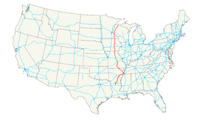
Route information Length: 1,286 mi[1] (2,070 km) Existed: 1926[1] – present Major junctions South end:  I-20 at Ruston, LA
 I-55 at Turrell, AR
 US 60 at Willow Springs, MO
 I-44 at Rolla, MO

 US 50/US 54 at Jefferson City, MO

 I-70/US 40 at Columbia, MO
 I-80 at Malcom, IA
 US 30 near Toledo, IA
 US 20 at Waterloo, IA
 US 52 at Rochester, MN
 I-90 at Rochester, MN
 I-94 at Baldwin, WI
North end:  US 2 at Ashland, WI
Highway system United States Numbered Highways
List • Bannered • Divided • ReplacedU.S. Route 63 (US 63) is a 1,286-mile (2,070 km) long north–south United States highway primarily in the Midwestern United States. The southern terminus of the route is at Interstate 20 in Ruston, Louisiana. The northern terminus is at U.S. Route 2 in Benoit, Wisconsin, about 60 miles (97 km) east of Duluth, Minnesota. It is not related to U.S. Route 163, which is located near the Four Corners Monument in the southwestern United States.
Contents
Route description
Louisiana
U.S. 63 overlaps U.S. 167 for its entire route in Louisiana, from Ruston north, to Junction City, at the Arkansas line, a distance of 35 miles (56 km).[2]
Arkansas
U.S. 63 overlaps numerous other Interstate and U.S. highways on its way from Junction City, at the Louisiana line, north to Mammoth Spring, at the Missouri line; along the way it crosses one U.S. highway twice, and just misses crossing three others twice [3]:
- Continuing from Ruston, Louisiana, U.S. 167 from Junction City to El Dorado
- I-530 and U.S. 65, along with U.S. 79, in Pine Bluff
- U.S. 79 again from Pine Bluff to Stuttgart
- U.S. 165 in Stuttgart
- U.S. 70 in Hazen
- I-40 from Hazen to West Memphis. A concurrent segment of U.S. 70 and U.S. 79 (again) serves as its service road just west of West Memphis, though they never cross; it also crosses U.S. 49 at Brinkley.
- I-55 from West Memphis to Turrell, silently picking up U.S. 61 at Turrell and U.S. 64 at Marion
- U.S. 49 again in Jonesboro
- U.S. 67 in the cities of Hoxie and Walnut Ridge, but only temporarily until the U.S. 67 freeway is extended from Newport to the Walnut Ridge-Hoxie area
- U.S. 412 alone from Portia to Imboden
- U.S. 62 and U.S. 412 from Imboden to Hardy; it just misses meeting U.S. 167 again at its northern terminus at Ash Flat, near Hardy
Many of these concurrencies and multiple crossings occurred when the south end of U.S. 63 was extended from Turrell to Ruston in 1999, in a very different direction from the Mammoth Spring-to-Turrell segment; the only non-concurrent parts of the extension are from Hazen to Stuttgart (formerly Arkansas Highway 11) and Pine Bluff to El Dorado (formerly Arkansas Highway 15). In addition, U.S. 63 from Jonesboro (including the U.S. 49 concurrency) to Turrell is designated as future Interstate 555, and will be yet another concurrency once that becomes final.
U.S. 63 from Jonesboro to Turrell is now bannered as "Future I-555" which is to be switched as soon as service roads are completed on either side of the 4-lane divided highway. It has been questioned on whether or not U.S. 63 will be rerouted to eliminate the dogleg from Jonesboro to West Memphis to Hazen. Possible reroutings could be U.S 63/49 from Jonesboro to Brinkley and U.S 63/70 from Brinkley to Hazen or U.S. 63/AR 1 from Jonesboro to Forrest City and U.S. 63/70 from Forrest City to Hazen.
Missouri
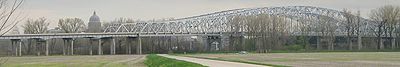 Jefferson City Bridge
The highway passes South-to-North through Missouri, from Arkansas to Iowa, serving cities such as Rolla, Jefferson City, Columbia, Moberly and Kirksville. Notable routes that are intersected include U.S. Route 60, Interstate 44 at Rolla, U.S. Route 50 (which it shares a concurrency with into Jefferson City south of the Missouri River until it reaches the junction with U.S. Route 54), U.S. Route 54 (which it overlaps in Jefferson City from the junction with U.S. Route 50 and crosses the Missouri River with on the Jefferson City Bridge), Interstate 70 at Columbia, U.S Route 24 at Moberly, U.S. Route 36 at Macon, and U.S. Route 136 at Lancaster. The road enters the state at Thayer and has alternating passing lanes from here to West Plains. From West Plains through Cabool, the road (concurrent with U.S. 60 from Willow Springs to Cabool) is four lanes. North of Cabool to its concurrency with US 50, US 63 mainly follows two-lane pavement, with alternating passing lanes added between Houston and Licking, and truck passing lanes added in other locations. Through Jefferson City up until Kirksville (excepting downtown Macon, where it returns to two-lane pavement), this highway remains on four-lane divided highway with some freeway sections in Jefferson City and Columbia. Just south of Kirksville, the highway splits into U.S. 63 and Business 63. U.S. 63 narrows to two lanes as it bypasses central Kirksville near the city's eastern boundary. Business 63 returns to four-lane divided highway for about a mile before it narrows into Baltimore Street through Kirksville. North of the city, U.S. 63 continues on two lanes to the Iowa border.
US 63 in Missouri was Route 7 from 1922 to 1926.
Iowa
U.S. 63 passes South-to-North through Iowa. It enters the state from Missouri south of Bloomfield. Between Ottumwa and Oskaloosa, the highway overlaps Iowa Highway 163. This segment is an expressway which connects Des Moines with Burlington, with freeway bypasses of Ottumwa and Eddyville. Near Malcom, U.S. 63 meets Interstate 80. Only a few miles later, it joins U.S. 6 westbound for several miles near Grinnell, then goes north again. At Toledo, it intersects U.S. 30 and at Waterloo, U.S. 63 meets U.S. 20. There is an expressway segment north of Waterloo to its intersection with Iowa Highway 3 and a freeway bypass around New Hampton. An additional expressway section, completing the four-lane expansion from Waterloo, north to New Hampton, is scheduled to open in the fall of 2012. The highway enters Minnesota just north of Chester.
Minnesota
U.S. 63 enters Minnesota from Iowa south of Spring Valley. It goes though downtown Rochester, U.S. 63 meets Interstate 90. After passing through Rochester, it continues north and meets U.S. Route 61 at Lake City. The two routes run concurrent to Red Wing, where U.S. 63 turns north and crosses the Mississippi River to enter Wisconsin over the Eisenhower Bridge. In Rochester, U.S. 63 is an expressway between I-90 and U.S. Route 52, however, it is planned to be upgraded to a freeway in the near future.
The Minnesota section of U.S. 63 is defined as Routes 59 and 161 in Minnesota Statutes §§ 161.114(2) and 161.115(92).[1],[2]
Wisconsin
U.S. 63 enters Wisconsin south of Hager City. Near Baldwin, U.S. 63 intersects Interstate 94. The highway briefly overlaps near Spooner with U.S. Route 53. At Trego, they separate and U.S. 63 runs southwest to northeast, ending near Benoit at U.S. Route 2.
History
Though U.S. 63 as a stand-alone highway had always ended at Turrell, Arkansas before the 1999 extension, in the past it was concurrent with U.S. 61, 64, 70, and 79 (and later I-55) on into Memphis, Tennessee, over the Memphis & Arkansas Bridge. Unlike the 1999 extension, this concurrency to Memphis was generally in line with the rest of U.S. 63. Though some maps continued to show this concurrency until 1999, Arkansas had not recognized U.S. 63 south of Turrell for many years, since at least the 1960s.
See also
Bannered routes
See also: Bannered routes of U.S. Route 63- U.S. Route 63 Business in Warren, Arkansas
- U.S. Route 63 Business in Pine Bluff, Arkansas
- U.S. Route 63 Business in Marked Tree, Arkansas
- U.S. Route 63 Business in Bono, Arkansas
- U.S. Route 63 Business in Hoxie, Arkansas
- U.S. Route 63 Business in Hardy, Arkansas
- U.S. Route 63 Business in West Plains, Missouri
- U.S. Route 63 Business in Willow Springs, Missouri
- U.S. Route 63 Business in Moberly, Missouri
- U.S. Route 63 Business in Ottumwa, Iowa
- U.S. Route 63 Business in New Hampton, Iowa
References
- ^ a b Droz, Robert V. U.S. Highways : From US 1 to (US 830). URL accessed 02:55, 4 July 2006 (UTC).
- ^ Louisiana's US Highways
- ^ Official Arkansas state highway map (large PDF)
 Main U.S. Routes
1 2 3 4 5 6 7 8 9 10 11 12 13 14 15 16 17 18 19 20 21 22 23 24 25 26 27 28 29 30 31 32 33 34 35 36 37 38 40 41 42 43 44 45 46 48 49 50 51 52 53 54 55 56 57 58 59 60 61 62 63 64 65 66 67 68 69 70 71 72 73 74 75 76 77 78 79 80 81 82 83 84 85 87 89 90 91 92 93 94 95 96 97 98 99 101 163 400 412 425 Lists U.S. Routes • Bannered • Divided • Bypassed Browse numbered routes ←  LA 62
LA 62LA LA 64  →
→←  U.S. 62
AR U.S. 64  →
→←  US 62
US 62MO I-64  →
→←  Iowa 62
IA Iowa 64  →
→←  MN 62
MN 62MN MN 64  →
→←  WIS 62
WI WIS 64  →Categories:
- U.S. Highway System
- U.S. Highways in Missouri
- U.S. Highways in Wisconsin
- U.S. Highways in Minnesota
- U.S. Highways in Iowa
- U.S. Highways in Arkansas
- U.S. Highways in Louisiana


Wikimedia Foundation. 2010.