- Memphis & Arkansas Bridge
-
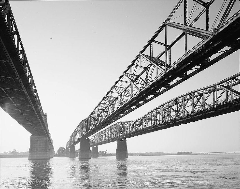
Memphis & Arkansas Bridge 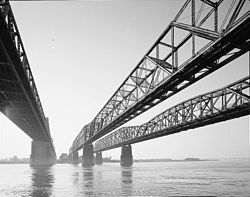
Memphis & Arkansas Bridge, left
Frisco Bridge, center
Harahan Bridge, rightOfficial name Memphis & Arkansas Bridge Carries 4 lanes of I-55/US 61/US 64/US 70/US 79 Crosses Mississippi River Locale West Memphis, Arkansas and Memphis, Tennessee ID number 79I00550101 Design Cantilevered through Truss bridge Total length 5,222 feet (1,592 m) Width 52 feet (16 m) Longest span 770 feet (235 m) Clearance below 112 feet (34 m) Opened December 17, 1949 Daily traffic 48,000 (2008) Coordinates Memphis & Arkansas Bridge

Location: Memphis, TN Coordinates: 35°7′39.02″N 90°4′32.42″W / 35.1275056°N 90.0756722°WCoordinates: 35°7′39.02″N 90°4′32.42″W / 35.1275056°N 90.0756722°W Built: 1949 Governing body: Tennessee NRHP Reference#: 01000139 Added to NRHP: February 16, 2001 The Memphis & Arkansas Bridge (per its nameplates), also known as the Memphis-Arkansas Bridge or Memphis-Arkansas Memorial Bridge, is a cantilevered through truss bridge[1] carrying Interstate 55 across the Mississippi River between West Memphis, Arkansas and Memphis, Tennessee. Memphians refer to this bridge as the "Old Bridge" to distinguish it from the "New Bridge", or Hernando de Soto Bridge, upstream.
The Memphis & Arkansas Bridge also carries U.S. Highways 61, 64, 70 and 79 from Memphis to West Memphis; it also carried U.S. Highway 63 prior to its truncation (and later rerouting) in Arkansas. The western terminus of Tennessee State Route 1 sits on the Tennessee-Arkansas boundary halfway across the bridge.
Having been built before the introduction of the Interstate Highway System, the span was not built to Interstate Highway standards, lacking the concrete barrier between the different directions of traffic which was added later. It was also built with a sidewalk on either side of the roadway, positioned just outside the steel truss girders.
The sidewalks, now also separated from the traffic lanes by concrete barriers, are accessible from Memphis city sidewalks on the Tennessee side, but give way to grassy slopes on the shoulders of I-55 on the Arkansas side. It is for this reason that the bridge, though listed as an official part of the Mississippi River Trail,[2] is marked as dangerous and a potential routing problem.[3] However, despite this accessibility issue, these lanes are still often used by bicyclists, as it is unusual to have bicycle and pedestrian access on a major bridge crossing the Mississippi River.
See also
References
Crossings of the Mississippi River Upstream
Frisco Bridge
BNSF RailwayMemphis & Arkansas Bridge


Downstream
Helena Bridge
 Categories:
- Bridges completed in 1949
- Bridges over the Mississippi River
- Buildings and structures in Memphis, Tennessee
- Cantilever bridges
- Interstate 55
- Transportation in Memphis, Tennessee
- Truss bridges
- U.S. Route 61
- Bridges on the National Register of Historic Places in Arkansas
- Transportation in Crittenden County, Arkansas
- Buildings and structures in Crittenden County, Arkansas
- Road bridges in Tennessee
- Road bridges in Arkansas
- United States bridge (structure) stubs
- Southern United States building and structure stubs
- Arkansas stubs
- Tennessee building and structure stubs


Wikimedia Foundation. 2010.