- Senatobia, Mississippi
Infobox Settlement
official_name = Senatobia, Mississippi
settlement_type =City
nickname = The Five Star City
motto =
imagesize =
image_caption =
image_
imagesize =
image_caption =
image_
mapsize = 250px
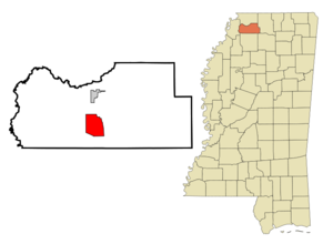
map_caption = Location of Senatobia, Mississippi
mapsize1 =
map_caption1 =subdivision_type = Country
subdivision_name =United States
subdivision_type1 = State
subdivision_name1 =Mississippi
subdivision_type2 = County
subdivision_name2 = Tate
government_footnotes =
government_type =
leader_title = Mayor
leader_name = Alan Callicott
leader_title1 =
leader_name1 =
established_title = Chartered
established_date = 1860unit_pref = Imperial
area_footnotes =area_magnitude =
area_total_km2 = 27.9
area_land_km2 = 27.8
area_water_km2 = 0.1
area_total_sq_mi = 10.8
area_land_sq_mi = 10.7
area_water_sq_mi = 0.0population_as_of = 2000
population_footnotes =
population_total = 6682
population_density_km2 = 240.0
population_density_sq_mi = 621.7timezone = Central (CST)
utc_offset = -6
timezone_DST = CDT
utc_offset_DST = -5
elevation_footnotes =
elevation_m = 88
elevation_ft = 289
latd = 34 |latm = 36 |lats = 59 |latNS = N
longd = 89 |longm = 58 |longs = 10 |longEW = Wpostal_code_type =
ZIP code
postal_code = 38668
area_code = 662
blank_name = FIPS code
blank_info = 28-66440
blank1_name = GNIS feature ID
blank1_info = 0677513
blank2_name = Highways
blank2_info = Click-Inline|Click-Inline|
Click-Inline|
Click-Inline|
website = http://www.cityofsenatobia.com
footnotes =Senatobia is a city located in Tate County,
Mississippi ,United States , and is the 15th largest municipality in theMemphis Metropolitan Area . TheUnited States Census Bureau 2006 population estimate for Senatobia was 6,878, a 2.93% increase since the 2000 Census. After a municipal annexation in 2007, Senatobia's population has risen to an estimated 7,448 [1] . It is thecounty seat of Tate CountyGR|6.Senatobia is the home of
Northwest Mississippi Community College , a state community college that provides two year academic and technical degree programs. Northwest's system-wide enrollment exceeds 6,200 on three campuses in Senatobia, Southaven, and Oxford. Senatobia is also the home of TheBaddour Center , a residential care facility for mild to moderately mentally retarded adults.On April 13, 1834 early settler James Peters purchased two sections of land from the Chickasaw Nation for the sum of $1.25 per acre. The land purchased later became the town of Senatobia. The name Senatobia, given by Charles Meriweather, was derived from the Indian word Senatohoba, which means “White Sycamore”--a symbol of "rest for the weary."
Senatobia received its charter as a municipality in 1860, thirteen years prior to the creation of Tate County and one year prior to the outbreak of the Civil War, during which the town's business section was burned twice by Federal Troops.
The city's zip code is 38668.
Geography
Senatobia is located at coor dms|34|36|59|N|89|58|10|W|city (34.616452, -89.969425)GR|1.
According to the
United States Census Bureau , the city has a total area of 10.8square mile s (27.9km² ), of which, 10.8 square miles (27.8 km²) of it is land and 0.04 square miles (0.1 km²) of it (0.28%) is water.Demographics
As of the
census GR|2 of 2000, there were 6,682 people, 2,137 households, and 1,498 families residing in the city. Thepopulation density was 621.7 people per square mile (240.0/km²). There were 2,239 housing units at an average density of 208.3/sq mi (80.4/km²). The racial makeup of the city was 68.03% White, 30.51% African American, 0.12% Native American, 0.22% Asian, 0.15% Pacific Islander, 0.24% from other races, and 0.72% from two or more races. Hispanic or Latino of any race were 0.85% of the population.There were 2,137 households out of which 38.3% had children under the age of 18 living with them, 47.4% were married couples living together, 19.4% had a female householder with no husband present, and 29.9% were non-families. 26.6% of all households were made up of individuals and 12.5% had someone living alone who was 65 years of age or older. The average household size was 2.60 and the average family size was 3.15.
In the city the population was spread out with 24.8% under the age of 18, 20.1% from 18 to 24, 26.0% from 25 to 44, 17.1% from 45 to 64, and 11.9% who were 65 years of age or older. The median age was 29 years. For every 100 females there were 89.1 males. For every 100 females age 18 and over, there were 85.4 males.
The median income for a household in the city was $33,698, and the median income for a family was $43,088. Males had a median income of $34,022 versus $22,000 for females. The
per capita income for the city was $16,434. About 13.0% of families and 17.7% of the population were below thepoverty line , including 21.3% of those under age 18 and 18.5% of those age 65 or over.Education
The City of Senatobia is served by the
Senatobia Municipal School District andMagnolia Heights School .Famous residents
*
Jessie Mae Hemphill , blues singer and guitarist (1933-2006)
*Othar Turner , fife player (1908-2003)
*Jim Harris, wrestler (b. 1950)
*O. B. McClinton , country and R&B singer/songwriter; his songs include "Back to Senatobia" and "Obie From Senatobie" (1940-1987)
*James "Jimmy" Dixon - World Class MagicianExternal links
* [http://www.thedemocrat.com/ Tate County Democrat]
* [http://www.cityofsenatobia.com/ City of Senatobia]
* [http://www.northwestms.edu/ Northwest Mississippi Community College]
*Mapit-US-cityscale|34.616452|-89.969425
Wikimedia Foundation. 2010.


