- T. O. Fuller State Park
-
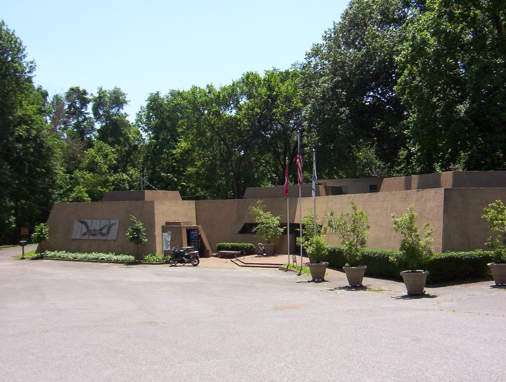
C.H. Nash Museum at Chucalissa
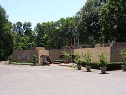 C.H. Nash Museum at Chucalissa (2009)

Location: 1987 Indian Village Drive, Memphis, Tennessee Coordinates: 35°3′45″N 90°7′44″W / 35.0625°N 90.12889°WCoordinates: 35°3′45″N 90°7′44″W / 35.0625°N 90.12889°W Area: 160 acres (0.65 km2)[1] Governing body: Private NRHP Reference#: 73001830 Significant dates Added to NRHP: May 7, 1973[2] Designated NHL: April 19, 1994[3] T.O. Fuller State Park is a state park in the city of Memphis in West Tennessee. It consists of 1,138 acres (4.6 km²) of mostly forest located in South Memphis on Mitchell Road. It is the only state park within the city limits and is one of the few locations within the city suitable for wildlife.
The park is named in honor of Dr. Thomas O. Fuller, who spent his life empowering and educating African Americans.[4] The park facilities were originally built for the use of African Americans in the Great Depression by the Civilian Conservation Corps (CCC). It was the second state park in the nation that was open to African Americans.[5]
Civilian Conservation Corps camp number 1464-SP-10, which was composed of African Americans, initiated construction of the park facilities in 1938. During excavation for a proposed swimming pool in 1940, CCC workers unearthed evidence of a prehistoric village. The site has since been developed as Chucalissa Indian Village, and includes a village, preserved archeological excavations, and the C.H. Nash Museum at Chucalissa.[6]
Contents
Facilities
Amenities at T.O. Fuller State Park include sheltered picnic areas, tennis courts, swimming pool, basketball courts, softball field, six miles (10 km) of hiking trails and camping facilities.[7] The park also has a golf course, which the state of Tennessee honored as the "Best State Park Golf Course" in 1998.[8] The park's nature center is open in the summer, and features natural history exhibits and programs.
Chucalissa Archaeological Site
During construction of T.O. Fuller State Park in 1938, the Civilian Conservation Corps discovered Native American artifacts on the site. The University of Tennessee initiated archaeological excavations of this Mississippian mound complex in 1940, but this work was interrupted by World War II. Excavations and other work at Chucalissa began once again in 1955. The facility is currently operated by the University of Memphis and serves as a gateway for understanding archaeology and the interpretation of Native American history.[9]
It was declared a National Historic Landmark in 1994.[1][3]
References
- ^ a b Gerald P. Smith, Charles McNutt, and Mark R. Barnes (January 29, 1993) (PDF). National Register of Historic Places Inventory-Nomination: Chucalissa Site / 40SY1. National Park Service. http://pdfhost.focus.nps.gov/docs/NHLS/Text/73001830.pdf. Retrieved 2009-06-22 and Accompanying eight photos, aerial, site, and artifacts, from 1970, 1980, 1987, 1990, and undatedPDF (1.02 MB)
- ^ "National Register Information System". National Register of Historic Places. National Park Service. 2007-01-23. http://nrhp.focus.nps.gov/natreg/docs/All_Data.html.
- ^ a b "Chucalissa Site". National Historic Landmark summary listing. National Park Service. http://tps.cr.nps.gov/nhl/detail.cfm?ResourceId=1390&ResourceType=Site. Retrieved 2008-06-29.
- ^ The Tennessee Encyclopedia of History and Culture: Thomas Oscar Fuller.
- ^ TN.gov Department of Environment & Conservation http://www.tennessee.gov/environment/parks/TOFuller/ Accessed August 2009
- ^ Tennessee Department of Environment & Conservation pamphlet: authorization no. 327152 (July 2009)
- ^ Moon Tennessee 2009 Edition by Susanna Henighan Potter
- ^ Insiders' Guide to Memphis by Rebecca Finlayson and Nicky Robertshaw 2006
- ^ "About Chucalissa" http://www.memphis.edu/chucalissa/about.htm Accessed August 2009
External links
- T. O. Fuller State Park official website
- Chucalissa website, University of Memphis
- Online Encyclopedia: Thomas O. Fuller (1867-1942)
U.S. National Register of Historic Places Topics Lists by states Alabama • Alaska • Arizona • Arkansas • California • Colorado • Connecticut • Delaware • Florida • Georgia • Hawaii • Idaho • Illinois • Indiana • Iowa • Kansas • Kentucky • Louisiana • Maine • Maryland • Massachusetts • Michigan • Minnesota • Mississippi • Missouri • Montana • Nebraska • Nevada • New Hampshire • New Jersey • New Mexico • New York • North Carolina • North Dakota • Ohio • Oklahoma • Oregon • Pennsylvania • Rhode Island • South Carolina • South Dakota • Tennessee • Texas • Utah • Vermont • Virginia • Washington • West Virginia • Wisconsin • WyomingLists by territories Lists by associated states Other City of Memphis & Memphis metropolitan area (counties in TN, MS and AR) Memphis topics History | Geography | Government | Economy | Education | Culture | Tourism | Sports | Transportation | Memphians


Memphis districts Memphis
neighborhoodsBelle Meade - Berclair - Binghampton - Capleville - Central Gardens - Chickasaw Gardens - Cooper-Young - Cordova - Douglass - Evergreen - Frayser - General DeWitt Spain Airport - Glenview - Harbor Town - Hickory Hill - High Point Terrace - Hollywood - Hyde Park - Lenox - Medical District - Mud Island - Normal Station - Nutbush - Orange Mound - Parkway Village - Raleigh - Riverside - Sherwood Forest - South Main - Uptown - Victorian Village - Vollintine Hills - Whitehaven - Wolfchase
Memphis
metro area
landmarksTennessee: A. Schwab's - Art Museum of the University of Memphis - AutoZone Stadium - Bartlett Museum - Beale Street - Bellevue Baptist Church - Belz Museum - Botanic Garden - Brooks Museum - Burkle Estate - Central Station - Chickasaw Bluff - Children's Museum - Chucalissa Museum - Cotton Museum - Davies Manor - Dixon Gallery and Gardens - Downtown Trolleys - Elmwood Cemetery - FedExForum - Fire Museum - Fort Assumption - Fort Wright - Graceland - Hernando de Soto Bridge - Liberty Bowl Stadium - Libertyland - Lichterman Nature Center - Lincoln American Tower - Magevney House - Mallory-Neely House - Meeman-Shelby Forest State Park - Memorial Park Cemetery - Memphis Cotton Exchange - Memphis International Airport - Memphis Motorsports Park - Memphis National Cemetery - Memphis Parkway System - Memphis Zoo - Mississippi River - Mississippi River Park - Mud Island Monorail - National Civil Rights Museum - National Ornamental Metal Museum - Oaklawn Garden - Orpheum Theatre - Overton Park - Peabody Hotel - Pink Palace - The Pyramid - Rhodes College - Rock N' Soul Museum - St. Jude Children's Research Hospital - St. Mary's Episcopal Cathedral - Shelby Farms - Stax Museum - Sun Studio - South Main Arts District - Tennessee Brewery - Tipton County Museum - T. O. Fuller State Park - Tom Lee Park - Union Station - University of Memphis - Victorian Village - Wolf River
Mississippi: Arkabutla Lake - Bally's Casino - DeSoto County Museum - DeSoto Civic Center - Gold Strike Casino - Harrah's Casino (formerly Grand Casino) - Holly Springs National Forest - Horseshoe Casino - Mississippi River - Resorts Casino Tunica - Sam's Town Gambling Hall - Tunica Resorts - Tunica Roadhouse Casino - Wall Doxey State Park
Arkansas: Horseshoe Lake - Mississippi River - Southland Greyhound Park - Wapanocca National Wildlife Refuge
Memphis
metro area
suburbsTennessee: Arlington - Bartlett - Brunswick - Capleville - Collierville - Covington - Eads - Ellendale - Fisherville - Germantown - Lakeland - Millington - Somerville - Shelby Forest
Mississippi: Hernando - Holly Springs - Horn Lake - Olive Branch - Senatobia - Southaven - Tunica - Tunica Resorts (former Robinsonville) - Walls
Arkansas: Marion - West Memphis
Metro area counties Categories:- Native American archeology
- Tennessee state parks
- National Historic Landmarks in Tennessee
- Archaeological sites in Tennessee
- University of Memphis
- Nature centers in Tennessee
- Civilian Conservation Corps in Tennessee
- Parks in Memphis, Tennessee


Wikimedia Foundation. 2010.