- DeSoto County, Mississippi
-
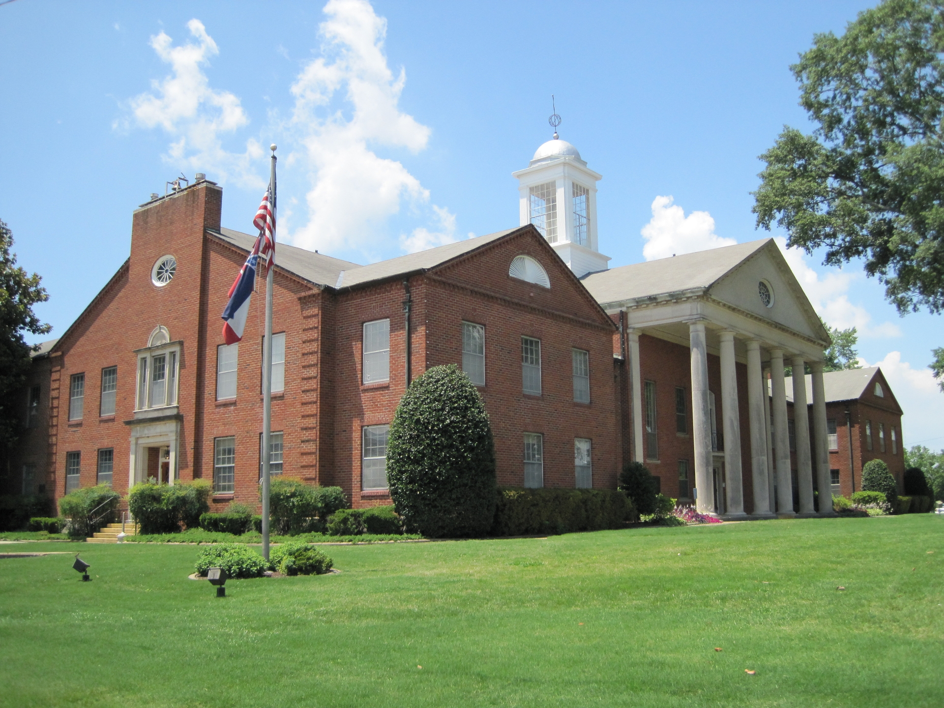
 DeSoto County courthouse in Hernando
DeSoto County, Mississippi 
Location in the state of Mississippi
Mississippi's location in the U.S.Founded February 9, 1836 Seat Hernando Largest city Southaven Area
- Total
- Land
- Water
496.77 sq mi (1,287 km²)
477.86 sq mi (1,238 km²)
18.91 sq mi (49 km²), 3.81%Population
- (2010)
- Density
161,252
225/sq mi (87/km²)Website www.desotoms.com DeSoto County is a county located in the U.S. state of Mississippi. DeSoto County is part of the Metropolitan Memphis (TN-AR-MS) Statistical Area. Its county seat is Hernando.[1] As of 2000, the population was 107,199. By 2010, the county had grown to a population of 161,252, largely due to African-American growth of over 150%.[2] It is now the third most populous county in Mississippi and the second most populous county in metro Memphis.
Contents
History
The county seat, Hernando, is named in honor of Spanish explorer Hernando de Soto, who allegedly died there in May 1542, although some believe that he died near Lake Village, Arkansas. See here for a list of sites associated with the de Soto Expedition.
Early history
At its organization on February 9, 1836, DeSoto County stretched from the Tennessee state line on the north to the Tate County line on the south; from the Mississippi River and Tunica County on the west to Marshall County on the east. A mistake in surveying placed the state line at what is now Winchester Road in Shelby County, Tennessee. In 1838, the line was resurveyed and moved to its present location.
Indian artifacts collected in DeSoto County link it with prehistoric groups of Woodland and Mississippian Indians.
The Mississippian Indians met Hernando DeSoto when he explored North Mississippi and, traditionally, came through DeSoto County. Some scholars project that DeSoto discovered the Mississippi River west of present-day Lake Cormorant, built rafts there and crossed to Crowley's Ridge, Arkansas. The National Park Service declared a "DeSoto Corridor" from the Chickasaw Bluff (Memphis) to Coahoma County, Mississippi.
Over 200 years passed and the Mississippian Indian culture disappeared, devastated by disease, but the Indian town named Chicasa which De Soto visited was probably the ancestral home of the Chickasaws who still lived in the area when Anglo-Americans began showing up. Their "Long Town," several villages close to each other, was near present-day Pontotoc. The Chickasaws claimed much of western Tennessee and northern Mississippi as their hunting grounds.
Negotiations, begun September, 1816, between the United States government and the Chickasaw nation, concluded with the signing of the Treaty of Pontotoc in October 1832. During these 16 years government officials and Chickasaw tribesmen worked out and revised treaty details.
From 1832 to 1836, government surveyors mapped the 6,442,000 acres (26,070 km2) of the Chickasaw doaldflamain, dividing it into townships, ranges and sections just as it remains today. The Mississippi Legislature formed 10 new counties, including DeSoto, Tunica, Marshall and Tate Counties, from this land.
By treaty the land was assigned by sections of 640 acres (2.6 km2) to individual Indians. The Chickasaws, a numerically small tribe, were assigned 2,422,400 acres (9,803 km2) of land using this formula. The government disposed of the remaining 400,000 at public sale. The Indians received at least $1.25 per acre for their land. The government land sold for 75 cents per acre or less.
Modern history
Located adjacent to Memphis, Tennessee, DeSoto County is now among the forty fastest growing counties in the United States. This fast-paced growth is attributed to white flight from Memphis. This has been most noticeable in the cities of Southaven, Olive Branch and Hernando. Also fueling development is the massive casino/resort complex located in neighboring Tunica County, Mississippi (the third largest gambling district in the United States).
Attractions
DeSoto County is known for its variety of golf courses. Velvet Cream, known as 'The Dip' by locals, is a landmark restaurant in the county. Serving hamburgers and ice cream since 1947, it is the oldest continually running restaurant in the county. In 2010, it was awarded 'Best Ice Cream in Mississippi' by USA Today.[3] DeSoto County was also previously known as the home of Maywood Beach, a water park that closed in 2003. (It had been open more than seventy years.)
DeSoto County Museum
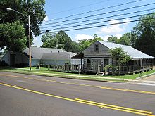 DeSoto County Museum and log house
A popular attraction is the DeSoto County Museum located in Hernando. The museum is open Tuesday through Saturday 10-5. There is no charge for admission but donations are accepted. Exhibits include displays on Hernando DeSoto, Civil War History, antebellum homes of the county, civil rights, and the history of each of the county's municipalities. Also located on the grounds of the museum is a log cabin from the 1850s.
Geography
DeSoto County is the most northwestern of Mississippi's 82 counties, in a corner that borders Tennessee and Arkansas. According to the 2000 census, the county has a total area of 496.77 square miles (1,286.6 km2), of which 477.86 square miles (1,237.7 km2) (or 96.19%) is land and 18.91 square miles (49.0 km2) (or 3.81%) is water.[4]
Geographic features
- Mississippi River
- Coldwater River
- Arkabutla Lake
- Mississippi Delta Bluffs
Major highways
I-55 recently underwent major widening from four lanes to ten lanes from the MS/TN state line south to Goodman Rd. Eventual widening of the freeway from Goodman Rd. to Star Landing Rd. is believed to include the addition of new exits at Nail Rd. and Star Landing Rd.
I-269 is a planned metro Memphis outer loop connecting the cities of Hernando and Olive Branch in Mississippi with Collierville and Millington in Tennessee. Expected to open within the next five to seven years.
Adjacent counties
- Shelby County, Tennessee - north
- Crittenden County, Arkansas - west
- Tunica County - south
- Tate County - south
- Marshall County - east

Shelby County, Tennessee (Memphis) Crittenden County, Arkansas 
Marshall County  DeSoto County, Mississippi

Tunica County Tate County Demographics
Historical populations Census Pop. %± 1840 7,002 — 1850 19,042 172.0% 1860 23,336 22.6% 1870 32,021 37.2% 1880 22,924 −28.4% 1890 24,183 5.5% 1900 24,751 2.3% 1910 23,130 −6.5% 1920 24,359 5.3% 1930 25,438 4.4% 1940 26,663 4.8% 1950 24,599 −7.7% 1960 23,891 −2.9% 1970 35,885 50.2% 1980 53,930 50.3% 1990 67,910 25.9% 2000 107,199 57.9% 2010 161,252 50.4% MS Counties 1900-1990
GeoHive - 2000 & 2010 statisticsAs of the census[5] of 2005 estimate, there were 137,004 people, 38,792 households, and 30,102 families residing in the county. The population density was 224 people per square mile (87/km²). There were 40,795 housing units at an average density of 85 per square mile (33/km²). The racial makeup of the county was 85.78% White, 11.40% Black or African American, 0.28% Native American, 0.62% Asian, 0.04% Pacific Islander, 1.13% from other races, and 0.76% from two or more races. 2.35% of the population were Hispanic or Latino of any race.
There were 38,792 households out of which 39.40% had children under the age of 18 living with them, 61.70% were married couples living together, 11.60% had a female householder with no husband present, and 22.40% were non-families. 18.10% of all households were made up of individuals and 5.60% had someone living alone who was 65 years of age or older. The average household size was 2.75 and the average family size was 3.11.
In the county the population was spread out with 28.20% under the age of 18, 8.20% from 18 to 24, 32.70% from 25 to 44, 22.10% from 45 to 64, and 8.90% who were 65 years of age or older. The median age was 34 years. For every 100 females there were 98.00 males. For every 100 females age 18 and over, there were 95.00 males.
The median income for a household in the county was $48,206, and the median income for a family was $53,590. Males had a median income of $38,032 versus $26,474 for females. The per capita income for the county was $20,468. 7.10% of the population and 5.60% of families were below the poverty line. 8.30% are under the age of 18 and 9.50% are 65 or older.
DeSoto County had the second highest per capita income in the State of Mississippi.
Communities
- Cities
- Towns
- Villages
- Census-designated places
- Unincorporated places
- Cockrum
- Eudora
- Lake Cormorant
- Lake View
- Lewisburg
- Mineral Wells
- Nesbit
- Pleasant Hill
Days, Mississippi
See also
References
- ^ "Find a County". National Association of Counties. http://www.naco.org/Counties/Pages/FindACounty.aspx. Retrieved 2011-06-07.
- ^ http://2010.census.gov/news/releases/operations/cb11-cn14.html
- ^ http://www.usatoday.com/travel/destinations/2010-08-26-best-ice-cream_N.htm
- ^ "Census 2000 U.S. Gazetteer Files: Counties". United States Census. http://www.census.gov/tiger/tms/gazetteer/county2k.txt. Retrieved 2011-02-13.
- ^ "American FactFinder". United States Census Bureau. http://factfinder.census.gov. Retrieved 2008-01-31.
Suggested reading
- Map Guide to the U.S. Federal Censuses, 1790–1920, Thorndale, William, and Dollarhide, William; Copyright 1987. (Historic state maps including evolution of DeSoto County)
External links
- DeSotoCountyOnline.com - Useful Information for Residents and Visitors.
- DeSotoMS.com - Official County Site.
- DeSoto County Economic Development Council - Official site.
- DeSoto Arts Council - Official site.
- Desoto County Museum, DeSoto County Historic Museum in Hernando
- The DeSoto Times online edition, the daily county newspaper based in Hernando (site under construction)
- The DeSoto County Tribune online edition, the weekly county newspaper based in Olive Branch
- The DeSoto Appeal online edition, a community edition of the Memphis, Tennessee-based Commercial Appeal
- An article from the Clarion-Ledger, providing insight into the contrasts amid DeSoto County's growth (22 December 1999)
Municipalities and communities of DeSoto County, Mississippi Cities 
Towns Villages CDPs Unincorporated
communitiesCockrum | Eudora | Handy Corner | Lake Cormorant | Lake View | Lewisburg | Mineral Wells | Nesbit | Pleasant Hill
City of Memphis & Memphis metropolitan area (counties in TN, MS and AR) Memphis topics History | Geography | Government | Economy | Education | Culture | Tourism | Sports | Transportation | Memphians


Memphis districts Memphis
neighborhoodsBelle Meade - Berclair - Binghampton - Capleville - Central Gardens - Chickasaw Gardens - Cooper-Young - Cordova - Douglass - Evergreen - Frayser - General DeWitt Spain Airport - Glenview - Harbor Town - Hickory Hill - High Point Terrace - Hollywood - Hyde Park - Lenox - Medical District - Mud Island - Normal Station - Nutbush - Orange Mound - Parkway Village - Raleigh - Riverside - Sherwood Forest - South Main - Uptown - Victorian Village - Vollintine Hills - Whitehaven - Wolfchase
Memphis
metro area
landmarksTennessee: A. Schwab's - Art Museum of the University of Memphis - AutoZone Stadium - Bartlett Museum - Beale Street - Bellevue Baptist Church - Belz Museum - Botanic Garden - Brooks Museum - Burkle Estate - Central Station - Chickasaw Bluff - Children's Museum - Chucalissa Museum - Cotton Museum - Davies Manor - Dixon Gallery and Gardens - Downtown Trolleys - Elmwood Cemetery - FedExForum - Fire Museum - Fort Assumption - Fort Wright - Graceland - Hernando de Soto Bridge - Liberty Bowl Stadium - Libertyland - Lichterman Nature Center - Lincoln American Tower - Magevney House - Mallory-Neely House - Meeman-Shelby Forest State Park - Memorial Park Cemetery - Memphis Cotton Exchange - Memphis International Airport - Memphis Motorsports Park - Memphis National Cemetery - Memphis Parkway System - Memphis Zoo - Mississippi River - Mississippi River Park - Mud Island Monorail - National Civil Rights Museum - National Ornamental Metal Museum - Oaklawn Garden - Orpheum Theatre - Overton Park - Peabody Hotel - Pink Palace - The Pyramid - Rhodes College - Rock N' Soul Museum - St. Jude Children's Research Hospital - St. Mary's Episcopal Cathedral - Shelby Farms - Stax Museum - Sun Studio - South Main Arts District - Tennessee Brewery - Tipton County Museum - T. O. Fuller State Park - Tom Lee Park - Union Station - University of Memphis - Victorian Village - Wolf River
Mississippi: Arkabutla Lake - Bally's Casino - DeSoto County Museum - DeSoto Civic Center - Gold Strike Casino - Harrah's Casino (formerly Grand Casino) - Holly Springs National Forest - Horseshoe Casino - Mississippi River - Resorts Casino Tunica - Sam's Town Gambling Hall - Tunica Resorts - Tunica Roadhouse Casino - Wall Doxey State Park
Arkansas: Horseshoe Lake - Mississippi River - Southland Greyhound Park - Wapanocca National Wildlife Refuge
Memphis
metro area
suburbsTennessee: Arlington - Bartlett - Brunswick - Capleville - Collierville - Covington - Eads - Ellendale - Fisherville - Germantown - Lakeland - Millington - Somerville - Shelby Forest
Mississippi: Hernando - Holly Springs - Horn Lake - Olive Branch - Senatobia - Southaven - Tunica - Tunica Resorts (former Robinsonville) - Walls
Arkansas: Marion - West Memphis
Metro area counties Categories:- Mississippi counties
- DeSoto County, Mississippi
- 1836 establishments in the United States
- Populated places established in 1836
- Memphis metropolitan area
- Mississippi counties on the Mississippi River


Wikimedia Foundation. 2010.