- West Hattiesburg, Mississippi
-
West Hattiesburg, Mississippi — CDP — Location of West Hattiesburg, Mississippi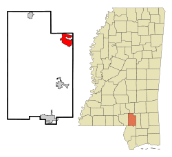
Coordinates: 31°19′16″N 89°22′3″W / 31.32111°N 89.3675°WCoordinates: 31°19′16″N 89°22′3″W / 31.32111°N 89.3675°W Country United States State Mississippi County Lamar Area – Total 7.2 sq mi (18.6 km2) – Land 7.1 sq mi (18.3 km2) – Water 0.1 sq mi (0.3 km2) Elevation 253 ft (77 m) Population (2000) – Total 16,305 – Density 892.0/sq mi (344.4/km2) Time zone Central (CST) (UTC-6) – Summer (DST) CDT (UTC-5) FIPS code 28-78890 GNIS feature ID 1867333 West Hattiesburg, also known as Oak Grove, is, in part, a census designated place (CDP) defined for statistical purposes in an urbanized area west of Hattiesburg, Mississippi in Lamar County, Mississippi, United States. It is part of the Hattiesburg, Mississippi Metropolitan Statistical Area. The population was 6,305, at the 2000 census. The statistics collected by the Census Bureau reflect the unincorporated area outside the city of Hattiesburg. In local usage, "West Hattiesburg" also refers to a portion of the city of Hattiesburg located to the west of the rest of the city and extending into the CDP. The city annexed more land from the CDP in 2003.
Contents
Geography
West Hattiesburg is located at 31°19′16″N 89°22′3″W / 31.32111°N 89.3675°W (31.321239, -89.367437)[1]. According to the United States Census Bureau, the CDP has a total area of 7.2 square miles (19 km2), of which, 7.1 square miles (18 km2) of it is land and 0.1 square miles (0.26 km2) of it is water. The total area is 1.39% water.
Demographics
As of the census[2] of 2000, there were 16,305 people, 4,464 households, and 2,601 families residing in the CDP. The population density was 892.0 people per square mile (377.3/km²). There were 2,633 housing units at an average density of 372.5/sq mi (143.8/km²). The racial makeup of the CDP was 74.88% White, 22.11% African American, 0.06% Native American, 1.63% Asian, 0.29% from other races, and 1.03% from two or more races. Hispanic or Latino of any race were 1.38% of the population.
There were 2,464 households out of which 32.9% had children under the age of 18 living with them, 47.3% were married couples living together, 14.0% had a female householder with no husband present, and 35.0% were non-families. 24.0% of all households were made up of individuals and 6.7% had someone living alone who was 65 years of age or older. The average household size was 2.50 and the average family size was 3.00.
In the CDP the population was spread out with 25.5% under the age of 18, 15.7% from 18 to 24, 30.8% from 25 to 44, 19.2% from 45 to 64, and 8.8% who were 65 years of age or older. The median age was 30 years. For every 100 females there were 91.1 males. For every 100 females age 18 and over, there were 87.2 males.
The median income for a household in the CDP was $44,663, and the median income for a family was $68,287. Males had a median income of $49,552 versus $43,873 for females. The per capita income for the CDP was $38,988. None of the families and none of the population were living below the poverty line, including no under eighteens and none of those over 64.
Incorporation
A movement for incorporation has been attempted repeatedly over the years, but has never come to a vote, and the courts have never ruled on it. The issues involve getting articles of incorporation which all would agree to, as well as who wants incorporation (who will profit, who will end up paying more in taxes).
Proponents say incorporation will benefit all residents, but the opposition says it will only benefit the persons who hold that property which is yet to be fully developed within the real estate market over the next few years. Another argument against incorporation is that the proposal and its budget outline didn't fully account for the additional expenditures and costs of running the new city. Proponents counter that the overall cost will be lower, because of a more distributed risk amongst homeowners, who would essentially bear about 80% of the additional taxes to support this city.
http://www.hattiesburgamerican.com has extensive archives about this issue, including opinion columns authored by the actual people engaged in the debate both pro and con. It's a good case study in local politics.
Education
Main article: Lamar County School DistrictOak Grove schools are among the Top 10 in Mississippi. They have been listed in the following:
High School(s)
Oak Grove High School (Grades 9-12) [1]
Middle School(s)
Oak Grove Middle School (Grades 6-8) [2]
Elementary School(s)
Oak Grove Upper Elementary School (Grades 4-5) [3]
Oak Grove Lower Elementary School (Grades 2-3) [4]
Oak Grove Primary School (Grades K-1)
References
- ^ "US Gazetteer files: 2010, 2000, and 1990". United States Census Bureau. 2011-02-12. http://www.census.gov/geo/www/gazetteer/gazette.html. Retrieved 2011-04-23.
- ^ "American FactFinder". United States Census Bureau. http://factfinder.census.gov. Retrieved 2008-01-31.
Municipalities and communities of Lamar County, Mississippi Cities Hattiesburg‡ | Lumberton‡ | Purvis
Town CDP West Hattiesburg
Other
communitiesBaxterville | Oloh
Footnotes ‡This populated place also has portions in an adjacent county or counties
Categories:- Populated places in Lamar County, Mississippi
- Census-designated places in Mississippi
- Hattiesburg metropolitan area


Wikimedia Foundation. 2010.