- Olive Branch, Mississippi
-
Olive Branch, Mississippi — City — Location of Olive Branch in the State of Mississippi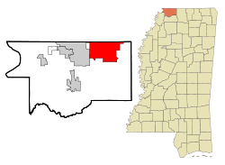
Coordinates: 34°57′37″N 89°50′30″W / 34.96028°N 89.84167°WCoordinates: 34°57′37″N 89°50′30″W / 34.96028°N 89.84167°W Country United States State Mississippi County DeSoto City Government - Mayor Samuel P. Rikard Area - Total 36.3 sq mi (94.0 km2) - Land 36.2 sq mi (93.7 km2) - Water 0.1 sq mi (0.2 km2) Elevation 387 ft (118 m) Population (United States Census 2007 estimate) - Total 30,675 - Density 847/sq mi (327/km2) Time zone CST (UTC-6) - Summer (DST) CDT (UTC-5) ZIP code 38654 Area code(s) 662 FIPS code 28-54040 GNIS feature ID 0690369 Website http://www.obms.us/ Olive Branch is a city in DeSoto County, Mississippi, United States. The population was 21,054 at the 2000 census. A July 1, 2008 United States Census Bureau estimate placed the population at 31,830, making it the ninth-largest city in the state of Mississippi.[1] Olive Branch is a suburb of Memphis, Tennessee and is part of the Memphis Metropolitan Statistical Area, a region that consists of three counties in southwest Tennessee, four counties in northwest Mississippi, and one county in eastern Arkansas.
Along with other fast growing suburban cities in DeSoto County, Olive Branch attributes most of its growth and development to the exodus of large numbers of middle-class families from central Memphis.
Contents
Geography
Olive Branch is located at 34°57′47″N 89°50′30″W / 34.96306°N 89.84167°W (34.963007, -89.841627)[2] in northeastern DeSoto County, less than 5 miles (8.0 km) from Memphis at the junction of U.S. Highway 78, and State Highways 302 (known locally as Goodman Road) and 305 (Germantown Road/Cockrum Street). The city's northern border is the Mississippi/Tennessee state line. The city of Southaven borders Olive Branch on the west, and unincorporated areas border the city to the east and south.[3]
According to the United States Census Bureau, the city has a total area of 36.3 square miles (94 km2), of which 36.2 square miles (94 km2) is land and 0.1 square miles (0.26 km2) (0.25%) is water.
History
The first permanent Anglo settlers in the area were Stephen Flinn and his wife's brother-in-law, Milton Blocker. On April 13, 1836, they purchased 1,280 acres (5.2 km2) of land – known as Sections 34 and 35 – in newly-created DeSoto County from Chickasaw chief Lush-Pun-Tubby for $1,600.[4][5] Flinn conveyed the land to Blocker for $6,400 in 1840. A small community initially known as Cowpens sprang up in the early 1840s. The name was changed to Watson's Crossroads in 1842. In 1846, when a post office was established, the name was changed again to Olive Branch. Mrs. Frances Wilson Blocker, a descendant of one the community's founders, suggested the name as a way to symbolize the biblical story of a dove bringing a branch to Noah. With the exception of a few skirmishes occurring in an area southwest of the community, Olive Branch escaped much of the destruction and violence during the Civil War.[4][5]
Olive Branch was incorporated as a town on May 1, 1874. Ben Wesson was elected as the first mayor.[6] At the first census conducted after incorporation in 1880, the population was 73. A railroad line was built through Olive Branch in 1885, connecting the town to Memphis and Birmingham. The town was officially designated a village on March 6, 1888.[4]
At the turn of the century, nearly 200 people lived in Olive Branch. In the ensuing years, several modern amenities were introduced in the village, including the first cotton gin (1910), a public water system (1922), and electrical service (1927).[5] T.H. Norvell's cheese plant (at the side of present-day BancorpSouth) opened in 1929, becoming the first major industry in Olive Branch. A public sewer system was built and local streets were paved circa 1940. The village experienced modest growth during the next few decades, rising from 441 in the 1940 census, to 534 in 1950, and 642 in 1960. Growth accelerated in the 1960s and by 1970, the population had more than doubled to 1,513. In 1971, a site located a few miles from downtown Olive Branch was chosen as the home of Holiday Inn University and Conference Center. Simultaneous with construction of the University, Holiday Inn began work on a 3,000-acre (12 km2) industrial park. This was followed by the opening of Olive Branch Airport in January 1973. With a runway length of 6,000 feet (1,800 m), it is currently one of Mississippi's five most active airports for landings and takeoffs.[7] U.S. Highway 78 was built through Olive Branch in 1974. Such developments and infrastructure improvements brought an influx of jobs, industries, and people to DeSoto County and Olive Branch.
The 1990s were a period of explosive growth in the city. 3,567 people lived in Olive Branch at the 1990 census. In 1996, a land annexation to the west doubled the city's total land area.[5] By 2000, the population had risen to 21,054, a 490 percent increase over the 1990 figure. With a population of just under 32,000 residents as of 2008, Olive Branch is the ninth-largest city in Mississippi, behind Greenville.[1]
In 2003, Memphis lost its only permanent indoor ice rink with the closure of the deeply troubled Mall of Memphis. A new rink is scheduled to open in Olive Branch in August 2011.
Demographics
Historical populations Census Pop. %± 1880 73 — 1890 199 172.6% 1900 198 −0.5% 1910 221 11.6% 1920 197 −10.9% 1930 336 70.6% 1940 441 31.3% 1950 534 21.1% 1960 642 20.2% 1970 1,513 135.7% 1980 2,067 36.6% 1990 3,567 72.6% 2000 21,054 490.2% Est. 2008 31,830 51.2% As of the census[8] of 2000, there were 21,054 people, 7,546 households, and 6,036 families residing in the city. The population density was 581.7 people per square mile (224.6/km²). There were 7,935 housing units at an average density of 219.2 per square mile (84.7/km²). The racial makeup of the city was 86.60% White, 11.30% African American, 0.20% Native American, 0.41% Asian, 0.75% from other races, and 0.73% from two or more races. Hispanic or Latino of any race were 1.46% of the population.
There were 7,546 households out of which 42.8% had children under the age of 18 living with them, 65.8% were married couples living together, 10.6% had a female householder with no husband present, and 20.0% were non-families. 16.3% of all households were made up of individuals and 5.1% had someone living alone who was 65 years of age or older. The average household size was 2.78 and the average family size was 3.13.
In the city the population was spread out with 29.5% under the age of 18, 6.8% from 18 to 24, 34.7% from 25 to 44, 20.0% from 45 to 64, and 8.9% who were 65 years of age or older. The median age was 33 years. For every 100 females there were 96.4 males. For every 100 females age 18 and over, there were 92.9 males.
The median income for a household in the city was $55,187, and the median income for a family was $60,851. Males had a median income of $42,288 versus $28,287 for females. The per capita income for the city was $22,680. About 3.9% of families and 5.2% of the population were below the poverty line, including 7.2% of those under age 18 and 5.6% of those age 65 or over.
People
NASCAR driver, Ricky Stenhouse, Jr., as well as Cartoonist Charles Boyce, creator of Compu-toon, the syndicated comic panel, were born in Olive Branch.
Economy
In 2010 Pinnacle Airlines Corp. considered moving its headquarters to Downtown Memphis and to Olive Branch, and the airline also considered keeping the headquarters in its current location by Memphis International Airport. Pinnacle selected Downtown Memphis.[9]
Education
The City of Olive Branch is served by the DeSoto County School District.
Transportation
Highways
U.S. Highway 78, which turns into Lamar Avenue in Memphis, TN, and Mississippi Highway 302 (MS-302/Goodman Road) are the main thoroughfares in the Olive Branch, MS area.[3]
Railroad
A railroad line to Birmingham from Memphis runs through Olive Branch, MS. It is used by BNSF.[4]
Airport
Olive Branch is served by Olive Branch Airport. It is one of the busiest airports in Mississippi.[4]
References
- ^ a b "Table 4: Annual Estimates of the Resident Population for Incorporated Places in Mississippi, Listed Alphabetically: April 1, 2000 to July 1, 2008" (CSV). United States Census Bureau, Population Division. 2009-07-01. http://www.census.gov/popest/cities/tables/SUB-EST2008-04-28.csv. Retrieved 2009-07-11.
- ^ "US Gazetteer files: 2010, 2000, and 1990". United States Census Bureau. 2011-02-12. http://www.census.gov/geo/www/gazetteer/gazette.html. Retrieved 2011-04-23.
- ^ a b "Maps". Olive Branch Old Towne Association. http://www.olivebrancholdtowne.com/maps.php. Retrieved 2009-07-11.[dead link]
- ^ a b c d e "Our History". City of Olive Branch. http://www.ci.olive-branch.ms.us/content/si_our_history.php. Retrieved 2009-07-12.[dead link]
- ^ a b c d "Dates in Our History". City of Olive Branch. http://www.ci.olive-branch.ms.us/content/si_historical_dates.php. Retrieved 2009-07-12.[dead link]
- ^ "Wesson House". Olive Branch Old Towne Association. http://www.olivebrancholdtowne.com/wesson.php. Retrieved 2009-07-12.[dead link]
- ^ "History". Olive Branch Chamber of Commerce. http://www.olivebranchms.com/OliveBranch/History/tabid/105/Default.aspx. Retrieved 2009-07-12.[dead link]
- ^ "American FactFinder". United States Census Bureau. http://factfinder.census.gov. Retrieved 2008-01-31.
- ^ Risher, Wayne. "Pinnacle's decision to move Downtown lifts hopes for other development." The Commercial Appeal. October 8, 2010. Retrieved on October 8, 2010.
External links
- City of Olive Branch - Official site.
- Olive Branch Chamber of Commerce
- Olive Branch Old Towne
- Information for Olive Branch and Surrounding Cities
Municipalities and communities of DeSoto County, Mississippi County seat: Hernando Cities 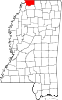
Towns Villages CDPs Unincorporated
communitiesCockrum | Eudora | Handy Corner | Lake Cormorant | Lake View | Lewisburg | Mineral Wells | Nesbit | Pleasant Hill
City of Memphis & Memphis metropolitan area (counties in TN, MS and AR) Memphis topics History | Geography | Government | Economy | Education | Culture | Tourism | Sports | Transportation | Memphians


Memphis districts Memphis
neighborhoodsBelle Meade - Berclair - Binghampton - Capleville - Central Gardens - Chickasaw Gardens - Cooper-Young - Cordova - Douglass - Evergreen - Frayser - General DeWitt Spain Airport - Glenview - Harbor Town - Hickory Hill - High Point Terrace - Hollywood - Hyde Park - Lenox - Medical District - Mud Island - Normal Station - Nutbush - Orange Mound - Parkway Village - Raleigh - Riverside - Sherwood Forest - South Main - Uptown - Victorian Village - Vollintine Hills - Whitehaven - Wolfchase
Memphis
metro area
landmarksTennessee: A. Schwab's - Art Museum of the University of Memphis - AutoZone Stadium - Bartlett Museum - Beale Street - Bellevue Baptist Church - Belz Museum - Botanic Garden - Brooks Museum - Burkle Estate - Central Station - Chickasaw Bluff - Children's Museum - Chucalissa Museum - Cotton Museum - Davies Manor - Dixon Gallery and Gardens - Downtown Trolleys - Elmwood Cemetery - FedExForum - Fire Museum - Fort Assumption - Fort Wright - Graceland - Hernando de Soto Bridge - Liberty Bowl Stadium - Libertyland - Lichterman Nature Center - Lincoln American Tower - Magevney House - Mallory-Neely House - Meeman-Shelby Forest State Park - Memorial Park Cemetery - Memphis Cotton Exchange - Memphis International Airport - Memphis Motorsports Park - Memphis National Cemetery - Memphis Parkway System - Memphis Zoo - Mississippi River - Mississippi River Park - Mud Island Monorail - National Civil Rights Museum - National Ornamental Metal Museum - Oaklawn Garden - Orpheum Theatre - Overton Park - Peabody Hotel - Pink Palace - The Pyramid - Rhodes College - Rock N' Soul Museum - St. Jude Children's Research Hospital - St. Mary's Episcopal Cathedral - Shelby Farms - Stax Museum - Sun Studio - South Main Arts District - Tennessee Brewery - Tipton County Museum - T. O. Fuller State Park - Tom Lee Park - Union Station - University of Memphis - Victorian Village - Wolf River
Mississippi: Arkabutla Lake - Bally's Casino - DeSoto County Museum - DeSoto Civic Center - Gold Strike Casino - Harrah's Casino (formerly Grand Casino) - Holly Springs National Forest - Horseshoe Casino - Mississippi River - Resorts Casino Tunica - Sam's Town Gambling Hall - Tunica Resorts - Tunica Roadhouse Casino - Wall Doxey State Park
Arkansas: Horseshoe Lake - Mississippi River - Southland Greyhound Park - Wapanocca National Wildlife Refuge
Memphis
metro area
suburbsTennessee: Arlington - Bartlett - Brunswick - Capleville - Collierville - Covington - Eads - Ellendale - Fisherville - Germantown - Lakeland - Millington - Somerville - Shelby Forest
Mississippi: Hernando - Holly Springs - Horn Lake - Olive Branch - Senatobia - Southaven - Tunica - Tunica Resorts (former Robinsonville) - Walls
Arkansas: Marion - West Memphis
Metro area counties Categories:- Cities in Mississippi
- Populated places in DeSoto County, Mississippi
- Memphis metropolitan area


Wikimedia Foundation. 2010.