- Crittenden County, Arkansas
-
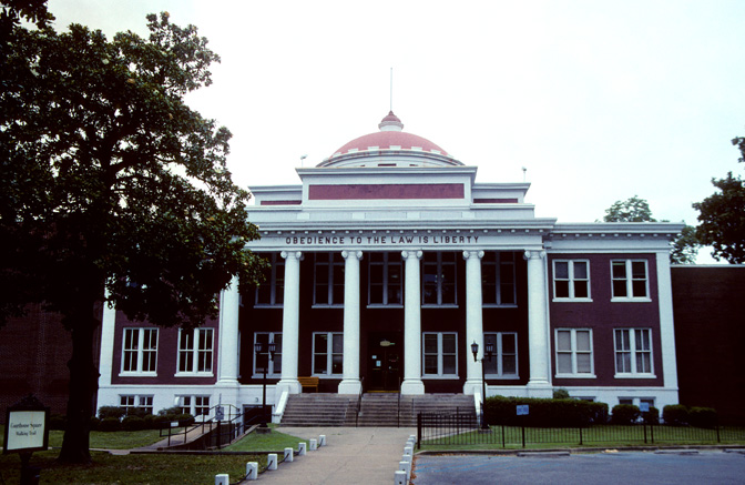
Crittenden County, Arkansas 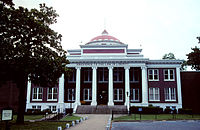 Crittenden County Courthouse in Marion, Arkansas
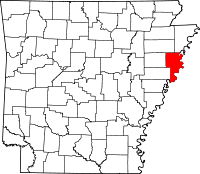
Location in the state of Arkansas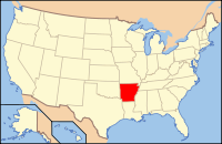
Arkansas's location in the U.S.Founded October 22, 1825 Named for Robert Crittenden Seat Marion Largest city West Memphis Area
- Total
- Land
- Water
636.69 sq mi (1,649 km²)
610.17 sq mi (1,580 km²)
26.52 sq mi (69 km²), 4.17%Population
- (2010)
- Density
50,902
83/sq mi (32.2/km²)Congressional district 1st Time zone Central: UTC-6/-5 Website www.crittendencountyarkansas.com/ Crittenden County is a county located in the U.S. state of Arkansas. As of the 2010 census, the population was 50,902. The county seat is Marion,[1] while its largest city is West Memphis. Crittenden County is Arkansas's twelfth county, formed on October 22, 1825, and named for Robert Crittenden, the first Secretary of the Arkansas Territory. Crittenden County was the site of the 1993 murders that led to the possibly wrongful conviction of the West Memphis Three, although the trial was moved to neighboring Craighead County.
Crittenden County is part of the Memphis, TN–MS–AR Metropolitan Statistical Area.
Contents
Geography
According to the 2000 census, the county has a total area of 636.69 square miles (1,649.0 km2), of which 610.17 square miles (1,580.3 km2) (or 95.83%) is land and 26.52 square miles (68.7 km2) (or 4.17%) is water.[2]
Major Highways
 Interstate 40
 Interstate 55
 U.S. Highway 61
 U.S. Highway 63
 U.S. Highway 64
 U.S. Highway 70
 U.S. Highway 79
 Highway 38
 Highway 42
 Highway 50
 Highway 77
 Highway 118
 Highway 131
 Highway 147
 Highway 149
 Highway 184
 Highway 191
 Highway 218
 Highway 816
Adjacent counties
- Mississippi County (northeast)
- Tipton County, Tennessee & Shelby County, Tennessee (east)
- DeSoto County, Mississippi (southeast)
- Tunica County, Mississippi (south)
- Lee County (southwest)
- St. Francis County & Cross County (west)
- Poinsett County (northwest)
National protected area
Demographics
Historical populations Census Pop. %± 1830 1,272 — 1840 1,561 22.7% 1850 2,648 69.6% 1860 4,920 85.8% 1870 3,831 −22.1% 1880 9,415 145.8% 1890 13,940 48.1% 1900 14,529 4.2% 1910 22,447 54.5% 1920 29,309 30.6% 1930 39,717 35.5% 1940 42,473 6.9% 1950 47,184 11.1% 1960 47,564 0.8% 1970 48,106 1.1% 1980 49,499 2.9% 1990 49,939 0.9% 2000 50,866 1.9% 2010 50,902 0.1% [3][4][5] 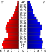 Age pyramid Crittenden County[6]
As of the census[7] of 2000, there were 50,866 people, 18,471 households, and 13,373 families residing in the county. The population density was 83 people per square mile (32/km²). There were 20,507 housing units at an average density of 34 per square mile (13/km²). The racial makeup of the county was 50.91% White, 47.05% Black or African American, 0.24% Native American, 0.47% Asian, 0.02% Pacific Islander, 0.66% from other races, and 0.64% from two or more races. 1.42% of the population were Hispanic or Latino of any race.
There were 18,471 households out of which 37.40% had children under the age of 18 living with them, 45.80% were married couples living together, 21.30% had a female householder with no husband present, and 27.60% were non-families. 23.70% of all households were made up of individuals and 8.00% had someone living alone who was 65 years of age or older. The average household size was 2.72 and the average family size was 3.23.
In the county the population was spread out with 31.10% under the age of 18, 9.40% from 18 to 24, 29.10% from 25 to 44, 20.50% from 45 to 64, and 9.90% who were 65 years of age or older. The median age was 32 years. For every 100 females there were 91.00 males. For every 100 females age 18 and over, there were 85.00 males.
The median income for a household in the county was $30,109, and the median income for a family was $34,982. Males had a median income of $31,299 versus $21,783 for females. The per capita income for the county was $14,424. About 21.00% of families and 25.30% of the population were below the poverty line, including 35.30% of those under age 18 and 23.70% of those age 65 or over.
Cities, towns, and townships
Cities
Towns
Townships
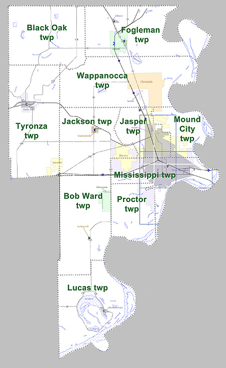
 Townships in Crittenden County, Arkansas as of 2010
Townships in Arkansas are the divisions of a county. Each township includes unincorporated areas and some may have incorporated towns or cities within part of their space. Townships have limited purposes in modern times. However, the US Census does list Arkansas population based on townships (often referred to as "minor civil divisions"). Townships are also of value for historical purposes in terms of genealogical research. Each town or city is within one or more townships in an Arkansas county based on census maps. The townships of Crittenden County are listed below with the town(s) and/or city that are fully or partially inside them listed in parentheses. [8][9]
- Black Oak
- Bob Ward (Anthonyville, Edmondson, small part of Jennette)
- Fogleman (Gilmore, Turrell)
- Jackson (Crawfordsville, part of Marion, part of West Memphis small part of Jennette)
- Jasper (Sunset, most of Marion, part of West Memphis, small part of Clarkedale)
- Lucas (Horseshoe Lake)
- Mississippi (most of West Memphis, part of Marion)
- Mound City (part of Marion, part of West Memphis, small part of Clarkedale)
- Proctor (part of West Memphis)
- Tyronza (Earle, most of Jennette)
- Wappanocca (Jericho, most of Clarkedale)
See also
References
- ^ "Find a County". National Association of Counties. http://www.naco.org/Counties/Pages/FindACounty.aspx. Retrieved 2011-06-07.
- ^ "Census 2000 U.S. Gazetteer Files: Counties". United States Census. http://www.census.gov/tiger/tms/gazetteer/county2k.txt. Retrieved 2011-02-13.
- ^ http://www.census.gov/population/www/censusdata/cencounts/files/ar190090.txt
- ^ http://factfinder2.census.gov
- ^ http://mapserver.lib.virginia.edu/
- ^ Based on 2000 census data
- ^ "American FactFinder". United States Census Bureau. http://factfinder.census.gov. Retrieved 2008-01-31.
- ^ US Census Bureau. 2011 Boundary and Annexation Survey (BAS): Crittenden County, AR (Map). http://www2.census.gov/geo/pvs/bas/bas11/st05_ar/cou/c05035_crittenden/BAS11C20503500000_000.pdf. Retrieved 20110820.
- ^ http://www.census.gov/geo/www/maps/DC10_GUBlkMap/cousub/dc10blk_st05_cousub.html#C

Poinsett County Mississippi County St. Francis County and Cross County 
Tipton County, Tennessee and Shelby County, Tennessee  Crittenden County, Arkansas

Lee County Tunica County, Mississippi DeSoto County, Mississippi Municipalities and communities of Crittenden County, Arkansas Cities Clarkedale | Earle | Marion | Sunset | Turrell | West Memphis

Towns Anthonyville | Crawfordsville | Edmondson | Gilmore | Horseshoe Lake | Jennette | Jericho
Unincorporated
communitiesAmanca | Blanton | Booker | Brice | Browns | Bruins | Chatfield | Cunningham Corner | Dixie | Ebony | Gaililee | Galet | Gavin | Grassy Lake Bottom | Harvard Yard | Heafer | Highland Farm | James Mill | Julius | Kate | Lambethville | Lansing | Lehi | Mallory Spur | Meneshea | Midway Corner | Miller | Nintey-six Corner | Norvell | Patoka | Pickney | Quarles | Redman Point | Riceville | Seyppel | Shannonville | st. Claire | Stacy | Three-Forks | Topaz | Twist | Vincent | Waverly
 State of Arkansas
Topics - Index
- Arkansans
- Constitution
- Delegations
- Geography
- Government
- Governor (List)
- History
- Images
- Places
- Transportation
- Visitor Attractions
Society - Culture
- Crime
- Demographics
- Economy
- Education
- Politics
Regions Metros Largest cities Other cities Counties - Arkansas
- Ashley
- Baxter
- Benton
- Boone
- Bradley
- Calhoun
- Carroll
- Chicot
- Clark
- Clay
- Cleburne
- Cleveland
- Columbia
- Conway
- Craighead
- Crawford
- Crittenden
- Cross
- Dallas
- Desha
- Drew
- Faulkner
- Franklin
- Fulton
- Garland
- Grant
- Greene
- Hempstead
- Hot Spring
- Howard
- Independence
- Izard
- Jackson
- Jefferson
- Johnson
- Lafayette
- Lawrence
- Lee
- Lincoln
- Little River
- Logan
- Lonoke
- Madison
- Marion
- Miller
- Mississippi
- Monroe
- Montgomery
- Nevada
- Newton
- Ouachita
- Perry
- Phillips
- Pike
- Poinsett
- Polk
- Pope
- Prairie
- Pulaski
- Randolph
- Saline
- Scott
- Searcy
- Sebastian
- Sevier
- Sharp
- St. Francis
- Stone
- Union
- Van Buren
- Washington
- White
- Woodruff
- Yell
Coordinates: 35°43′16″N 90°04′51″W / 35.72111°N 90.08083°W
Categories:- Arkansas counties
- Crittenden County, Arkansas
- 1825 establishments in the United States
- Populated places established in 1825
- Memphis metropolitan area
- Arkansas counties on the Mississippi River


Wikimedia Foundation. 2010.