- Cleburne County, Arkansas
-
Cleburne County, Arkansas 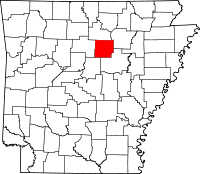
Location in the state of Arkansas
Arkansas's location in the U.S.Founded February 20, 1883 Seat Heber Springs Area
- Total
- Land
- Water
591.91 sq mi (1,533 km²)
553.05 sq mi (1,432 km²)
38.86 sq mi (101 km²), 6.57%Population
- (2010)
- Density
25,970
47/sq mi (18.1/km²)Congressional district 1st Cleburne County is a county located in the U.S. state of Arkansas. As of 2010, the population was 25,970. The county seat and most populous city in the county is Heber Springs,[1] while the largest city by area is Greers Ferry. Cleburne County was formed on February 20, 1883, and named for Confederate General Patrick Cleburne. It is also the last of Arkansas's 75 counties to be formed. Cleburne is an alcohol prohibition or dry county.
Contents
Geography
According to the 2000 census, the county has a total area of 591.91 square miles (1,533.0 km2), of which 553.05 square miles (1,432.4 km2) (or 93.43%) is land and 38.86 square miles (100.6 km2) (or 6.57%) is water.[2] Much of the water area in the County includes Greers Ferry Lake, which extends westward into neighboring Van Buren County.
Major highways
 Arkansas Highway 5
 Arkansas Highway 16
 Arkansas Highway 25
 Arkansas Highway 25 Business
 Arkansas Highway 25 Spur
 Arkansas Highway 87
 Arkansas Highway 92
 Arkansas Highway 107
 Arkansas Highway 110
 Arkansas Highway 124
 Arkansas Highway 210
 Arkansas Highway 225
 Arkansas Highway 263
 Arkansas Highway 336
 Arkansas Highway 337
 Arkansas Highway 356
 Arkansas Highway 980
Adjacent counties
- Stone County (north)
- Independence County (northeast)
- White County (southeast)
- Faulkner County (southwest)
- Van Buren County (west)
Demographics
Historical populations Census Pop. %± 1890 7,884 — 1900 9,628 22.1% 1910 11,903 23.6% 1920 12,696 6.7% 1930 11,373 −10.4% 1940 13,134 15.5% 1950 11,487 −12.5% 1960 9,059 −21.1% 1970 10,349 14.2% 1980 16,909 63.4% 1990 19,411 14.8% 2000 24,046 23.9% 2010 25,970 8.0% [3][4][5] 
As of the census[7] of 2000, there were 24,046 people, 10,190 households, and 7,408 families residing in the county. The population density was 44 people per square mile (17/km²). There were 13,732 housing units at an average density of 25 per square mile (10/km²). The racial makeup of the county was 98.20% White, 0.12% Black or African American, 0.47% Native American, 0.15% Asian, 0.02% Pacific Islander, 0.15% from other races, and 0.89% from two or more races. 1.17% of the population were Hispanic or Latino of any race.
There were 10,190 households out of which 26.30% had children under the age of 18 living with them, 61.70% were married couples living together, 7.90% had a female householder with no husband present, and 27.30% were non-families. 24.40% of all households were made up of individuals and 12.30% had someone living alone who was 65 years of age or older. The average household size was 2.33 and the average family size was 2.74.
In the county the population was spread out with 21.30% under the age of 18, 6.60% from 18 to 24, 24.10% from 25 to 44, 26.90% from 45 to 64, and 21.10% who were 65 years of age or older. The median age was 44 years. For every 100 females there were 93.90 males. For every 100 females age 18 and over, there were 92.50 males.
The median income for a household in the county was $31,531, and the median income for a family was $37,273. Males had a median income of $28,844 versus $19,672 for females. The per capita income for the county was $17,250. About 9.00% of families and 13.10% of the population were below the poverty line, including 17.10% of those under age 18 and 11.90% of those age 65 or over.
Cities and towns
Townships
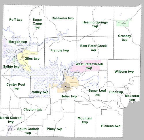
 Townships in Cleburne County, Arkansas as of 2010
Townships in Arkansas are the divisions of a county. Each township includes unincorporated areas and some may have incorporated towns or cities within part of their space. Townships have limited purposes in modern times. However, the US Census does list Arkansas population based on townships (often referred to as "minor civil divisions"). Townships are also of value for historical purposes in terms of genealogical research. Each town or city is within one or more townships in an Arkansas county based on census maps. The townships of Cleburne County are listed below with the town(s) and/or city that are fully or partially inside them listed in parentheses. [8][9]
- California
- Center Post
- Clayton
- East Peter Creek
- Francis
- Giles (Greers Ferry)
- Grassey (Concord)
- Heaing Springs
- Heber (most of Heber Springs)
- McJester
- Morgan (part of Fairfield Bay)
- Mountain
- North Cadron (part of Quitman)
- Pickens
- Pine
- Piney
- Poff
- Saline (Higden)
- South Cadron (part of Quitman)
- Sugar Camp
- Sugar Loaf
- Valley (part of Heber Springs)
- West Peter Creek (Tumbling Shoals)
- Wilburn
See also
References
- ^ "Find a County". National Association of Counties. http://www.naco.org/Counties/Pages/FindACounty.aspx. Retrieved 2011-06-07.
- ^ "Census 2000 U.S. Gazetteer Files: Counties". United States Census. http://www.census.gov/tiger/tms/gazetteer/county2k.txt. Retrieved 2011-02-13.
- ^ http://www.census.gov/population/www/censusdata/cencounts/files/ar190090.txt
- ^ http://factfinder2.census.gov
- ^ http://mapserver.lib.virginia.edu/
- ^ Based on 2000 census data
- ^ "American FactFinder". United States Census Bureau. http://factfinder.census.gov. Retrieved 2008-01-31.
- ^ US Census Bureau. 2011 Boundary and Annexation Survey (BAS): Cleburne County, AR (Map). http://www2.census.gov/geo/pvs/bas/bas11/st05_ar/cou/c05023_cleburne/BAS11C20502300000_000.pdf. Retrieved 20110807.
- ^ http://www.census.gov/geo/www/maps/DC10_GUBlkMap/cousub/dc10blk_st05_cousub.html#C

Stone County Independence County Van Buren County 
 Cleburne County, Arkansas

Faulkner County White County Municipalities and communities of Cleburne County, Arkansas Cities 
Towns CDP Tumbling Shoals
Unincorporated
communitiesDrasco | Edgemont | Hopewell | Ida | Prim | Tannenbaum | Wilburn
Footnotes ‡This populated place also has portions in an adjacent county or counties
 State of Arkansas
Topics - Index
- Arkansans
- Constitution
- Delegations
- Geography
- Government
- Governor (List)
- History
- Images
- Places
- Transportation
- Visitor Attractions
Society - Culture
- Crime
- Demographics
- Economy
- Education
- Politics
Regions Metros Largest cities Other cities Counties - Arkansas
- Ashley
- Baxter
- Benton
- Boone
- Bradley
- Calhoun
- Carroll
- Chicot
- Clark
- Clay
- Cleburne
- Cleveland
- Columbia
- Conway
- Craighead
- Crawford
- Crittenden
- Cross
- Dallas
- Desha
- Drew
- Faulkner
- Franklin
- Fulton
- Garland
- Grant
- Greene
- Hempstead
- Hot Spring
- Howard
- Independence
- Izard
- Jackson
- Jefferson
- Johnson
- Lafayette
- Lawrence
- Lee
- Lincoln
- Little River
- Logan
- Lonoke
- Madison
- Marion
- Miller
- Mississippi
- Monroe
- Montgomery
- Nevada
- Newton
- Ouachita
- Perry
- Phillips
- Pike
- Poinsett
- Polk
- Pope
- Prairie
- Pulaski
- Randolph
- Saline
- Scott
- Searcy
- Sebastian
- Sevier
- Sharp
- St. Francis
- Stone
- Union
- Van Buren
- Washington
- White
- Woodruff
- Yell
Categories:- Arkansas counties
- Cleburne County, Arkansas
- 1883 establishments in the United States
- Populated places established in 1883


Wikimedia Foundation. 2010.