- Ouachita Mountains
-
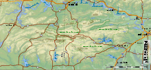
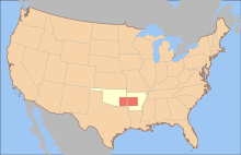
The Ouachita Mountains (pronounced /ˈwɒʃɨtɔː/ wosh-i-taw)[1] are a mountain range in west central Arkansas and southeastern Oklahoma. The range's subterranean roots may extend as far as central Texas, or beyond it to the current location of the Marathon Uplift. Along with the Ozark Mountains, the Ouachita Mountains form the U.S. Interior Highlands, one of the few major mountainous regions between the Rocky Mountains and the Appalachian Mountains.[2][3] The highest peak in the Ouachitas is Mount Magazine in west-central Arkansas which rises to 2,753 feet (839 m).
Contents
Etymology
The word Ouachita is composed of two Choctaw words: ouac, a buffalo, and chito, large. It means the country of large buffaloes, numerous herds of those animals having formerly covered the prairies of Ouachita.[4]
Geology and physiography
The Ouachita Mountains are a physiographic section of the larger Ouachita province (which includes both the Ouachita Mountains and the Arkansas Valley), which in turn is part of the larger Interior Highlands physiographic division.[5]
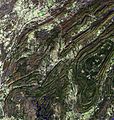
The Ouachita Mountains are fold mountains like the Appalachian Mountains to the east, and were originally part of that range. During the Pennsylvanian part of the Carboniferous period, about 300 million years ago, the coastline of the Gulf of Mexico ran through the central parts of Arkansas. As the South American plate drifted northward, a subduction zone was created in this region. The South American oceanic crust was forced underneath the less-dense North American continental crust. Geologists call this collision the Ouachita orogeny. The collision buckled the continental crust, producing the fold mountains we call the Ouachitas. At one time the Ouachita Mountains were very similar in height to the current elevations of the Rocky Mountains. Because of the Ouachitas' age, the craggy tops have eroded away, leaving the low formations that used to be the heart of the mountains.
Unlike most other mountain ranges in the United States, the Ouachitas run east and west rather than north and south. Also, the Ouachitas are distinctive in that volcanism, metamorphism, and intrusions are notably absent throughout most of the system.
The Ouachitas are noted for quartz crystal deposits around the Mount Ida area and for renowned Arkansas novaculite whetstones. This quartz was formed during the Ouachita orogeny, as folded rocks cracked and allowed fluids from deep in the Earth to fill the cracks.
The Ouachita Mountain area of Arkansas is dominated by Cambrian through Pennsylvanian clastic sediments, with the lower Collier formation in the core of the range and the Atoka formation on the flanks. The Atoka Formation, formed in the Pennsylvanian Period, is a sequence of marine, mostly tan to gray silty sandstones and grayish-black shales. Some rare calcareous beds and siliceous shales are known.[6] The Collier sequence is composed of gray to black, lustrous shale containing occasional thin beds of dense, black, and intensely fractured chert. An interval of bluish-gray, dense to spary, thin-bedded limestone may be present. Near its top, the limestone is conglomeratic and pelletoidal, in part, with pebbles and cobbles of limestone, chert, meta-arkose, and quartz. It was formed during the Late Cambrian.[6]
Flora
The mountains are known to contain at least 15 endemic plant species (i.e. plants that occur nowhere else). These include Sabatia arkansana, Valerianella nuttallii, Liatris compacta and Quercus acerifolia.[7]
Tourism
The Ouachita Mountains contain the Ouachita National Forest, Hot Springs National Park and Lake Ouachita, as well as numerous state parks and scenic byways. They also contain the Ouachita National Recreation Trail, a 223-mile-long (359 km) hiking trail through the heart of the mountains. The trail runs from Talimena State Park in Oklahoma to Pinnacle Mountain State Park near Little Rock, Arkansas. It is a well maintained, premier trail for hikers, backpackers, and mountain bikers (for only selected parts of the trail).
The Talimena Scenic Byway begins at Mena, Arkansas, and traverses 54 miles (87 km) of Winding Stair and Rich Mountains, long narrow east-west ridges which extend into Oklahoma. Rich Mountain reaches an elevation of 2,681 feet (817 m) in Arkansas near the Oklahoma border. The 2-lane winding road is similar in routing, construction, and scenery to the Blue Ridge Parkway of the Appalachian Mountains.[8]
History
The mountains were home to the Ouachita tribe, for which they were named. Later French explorers translated the name to its present spelling. The first recorded exploration was in 1541 by Hernando de Soto. Later, in 1804, President Jefferson sent William Dunbar and Dr. George Hunter to the area after the Louisiana Purchase. Hot Springs National Park became one of the nation's first parks in 1832. The Battle of Devil's Backbone was fought here at the ridge of the same name in 1863. In August 1990, the U.S. Forest Service discontinued clearcutting as the primary tool for harvesting and regenerating short leaf, pine and hardwood forests in the Ouachita National Forest.
References
- ^ "Ouachita Definition". dictionary.com. Random House, Inc.. http://dictionary.reference.com/browse/ouachita. Retrieved July 24, 2009.
- ^ "Managing Upland Forests of the Midsouth". United States Forestry Service. http://www.srs.fs.usda.gov/4106/about/HotSpringsOffice.htm. Retrieved 2007-10-13.
- ^ "A Tapestry of Time and Terrain: The Union of Two Maps - Geology and Topography". United States Geological Survey. http://tapestry.usgs.gov/physiogr/physio.html. Retrieved 2007-10-13.
- ^ Harlan, R. 1834. Notice of fossil bones found in the Tertiary formation of the State of Louisiana. Trans. Amer. Philos. Soc. iv pp. 397-403.
- ^ "Physiographic divisions of the conterminous U. S.". U.S. Geological Survey. http://water.usgs.gov/GIS/metadata/usgswrd/XML/physio.xml. Retrieved 2007-12-06.
- ^ a b http://www.geology.arkansas.gov/geology/strat_arvalley_ouachitamtn.htm Stratigraphic Summary of the Arkansas Valley and Ouachita Mountains
- ^ Pringle, J. S.; Witsell, T. (2005). "A new species of Sabatia (Gentianaceae) from Saline County, Arkansas". Sida 21 (3): 1249–1262. Archived from the original on 2007-07-11. http://web.archive.org/web/20070711020730/http://www.naturalheritage.com/resources/misc/tech/pdfs/SABATIA.pdf. Retrieved 2007-07-10
- ^ http://www.trais.com/tcatalog_trail.aspx?trailid=XFA101-040, accessed 11 Mar 2011
Further reading
External links
- Geology of the Ouachita Mountains, from a rockhound's perspective.
- Friends of the Ouachita Trail (FoOT)
- Largest lake in the Ouachita Mountain
Subfields of physical geography 
 State of Oklahoma
Oklahoma City (capital) Topics Society Culture · Crime · Demographics · Economy · Education · Politics
Regions Arklatex | Central | Cherokee Outlet | Cross Timbers | Four State Area | Flint Hills | Green Country | Kiamichi Country | Little Dixie | Northwestern | Oklahoma City Metro | Ouachita Mountains | The Ozarks | Panhandle | South Central | Southwestern
Largest cities Broken Arrow | Edmond | Enid | Lawton | Midwest City | Moore | Norman | Oklahoma City | Stillwater | Tulsa
Counties Adair | Alfalfa | Atoka | Beaver | Beckham | Blaine | Bryan | Caddo | Canadian | Carter | Cherokee | Choctaw | Cimarron | Cleveland | Coal | Comanche | Cotton | Craig | Creek | Custer | Delaware | Dewey | Ellis | Garfield | Garvin | Grady | Grant | Greer | Harmon | Harper | Haskell | Hughes | Jackson | Jefferson | Johnston | Kay | Kingfisher | Kiowa | Latimer | Le Flore | Lincoln | Logan | Love | Major | Marshall | Mayes | McClain | McCurtain | McIntosh | Murray | Muskogee | Noble | Nowata | Okfuskee | Oklahoma | Okmulgee | Osage | Ottawa | Pawnee | Payne | Pittsburg | Pontotoc | Pottawatomie | Pushmataha | Roger Mills | Rogers | Seminole | Sequoyah | Stephens | Texas | Tillman | Tulsa | Wagoner | Washington | Washita | Woods | Woodward
 State of Arkansas
Little Rock (capital) Topics Index · Arkansans Constitution · Delegations · Geography · Government · Governor (List) · History · Images · Places · Transportation · Visitor Attractions
Society Culture · Crime · Demographics · Economy · Education · Politics
Regions Arkansas River Valley · Ark‑La‑Tex · Bayou Bartholomew · Central Arkansas · Crowley's Ridge · Four State Area · Delta · Mississippi Alluvial Plain · New Madrid Seismic Zone · Northwest Arkansas · Osage Plains · Ouachita Mountains · Ozarks · Piney Woods · South Arkansas · Timberlands · Western Arkansas
Metros Largest cities Little Rock · Fort Smith · Fayetteville · Springdale · Jonesboro · North Little Rock · Conway · Rogers · Pine Bluff · Bentonville
Other cities Batesville · Benton · Blytheville · Cabot · El Dorado · Harrison · Helena‑West Helena · Hope · Hot Springs · Jacksonville · Mountain Home · Paragould · Russellville · Searcy · Sherwood · Texarkana · Van Buren · West Memphis
Counties Arkansas · Ashley · Baxter · Benton · Boone · Bradley · Calhoun · Carroll · Chicot · Clark · Clay · Cleburne · Cleveland · Columbia · Conway · Craighead · Crawford · Crittenden · Cross · Dallas · Desha · Drew · Faulkner · Franklin · Fulton · Garland · Grant · Greene · Hempstead · Hot Spring · Howard · Independence · Izard · Jackson · Jefferson · Johnson · Lafayette · Lawrence · Lee · Lincoln · Little River · Logan · Lonoke · Madison · Marion · Miller · Mississippi · Monroe · Montgomery · Nevada · Newton · Ouachita · Perry · Phillips · Pike · Poinsett · Polk · Pope · Prairie · Pulaski · Randolph · Saline · Scott · Searcy · Sebastian · Sevier · Sharp · St. Francis · Stone · Union · Van Buren · Washington · White · Woodruff · Yell
Categories:- Ouachita Mountains
- Geography of Scott County, Arkansas
- Geography of Montgomery County, Arkansas
- Geography of Le Flore County, Oklahoma
- Geography of Polk County, Arkansas
- Geography of Yell County, Arkansas
- Geography of McCurtain County, Oklahoma
- Geography of Garland County, Arkansas
- Geography of Perry County, Arkansas
- Geography of Saline County, Arkansas
- Geography of Sebastian County, Arkansas
- Geography of Logan County, Arkansas
- Geography of Pike County, Arkansas
- Geography of Ashley County, Arkansas
- Geography of Howard County, Arkansas
- Geography of Hot Spring County, Arkansas
Wikimedia Foundation. 2010.


