- Jefferson County, Arkansas
-
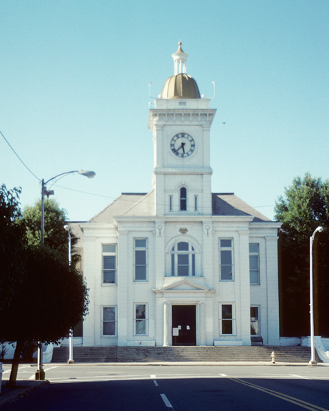
Jefferson County, Arkansas 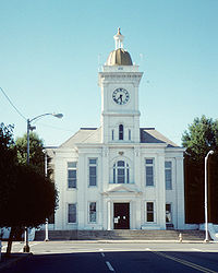 Jefferson County courthouse in Pine Bluff, Arkansas
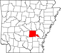
Location in the state of Arkansas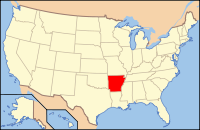
Arkansas's location in the U.S.Founded November 2, 1829 Seat Pine Bluff Area
- Total
- Land
- Water
913.70 sq mi (2,366 km²)
884.82 sq mi (2,292 km²)
28.88 sq mi (75 km²), 3.16%Population
- (2010)
- Density
77,435
87/sq mi (33.78/km²)Website www.jeffersoncountyar.gov Jefferson County is a county located in the U.S. state of Arkansas. Its population was 77,435 at the 2010 United States Census. It is included in the Pine Bluff Metropolitan Statistical Area. Jefferson County's county seat and largest city is Pine Bluff. Jefferson County is Arkansas's 21st county, formed on November 2, 1829, from portions of Arkansas and Pulaski counties, and named for Thomas Jefferson, third President of the United States.
Contents
Geography
According to the 2000 census, the county has a total area of 913.70 square miles (2,366.5 km2), of which 884.82 square miles (2,291.7 km2) (or 96.84%) is land and 28.88 square miles (74.8 km2) (or 3.16%) is water.[1] About 75% of the county including the largest city, Pine Bluff, is located in the Arkansas Delta with the remaining portion in the Arkansas Timberlands. Consequently, it is largely low lying flatland to the east used primarily for agriculture and expanses of trees used for timber to the west.
History
In 1886, Jefferson County produced 55,120 bales of cotton, the most in Arkansas, and the second-most throughout the South.[2] Transportation companies serving the county at the time included the Cotton Belt Route, the St. Louis – San Francisco Railway, Missouri Pacific, the Arkansas River Packet Company, the Wiley Jones Street Car Lines, and the Citizens Street Railway Company.[3]
Demographics
Historical populations Census Pop. %± 1830 772 — 1840 2,566 232.4% 1850 5,834 127.4% 1860 14,971 156.6% 1870 15,733 5.1% 1880 22,386 42.3% 1890 40,881 82.6% 1900 40,972 0.2% 1910 52,734 28.7% 1920 60,330 14.4% 1930 64,154 6.3% 1940 65,101 1.5% 1950 76,075 16.9% 1960 81,373 7.0% 1970 85,329 4.9% 1980 90,718 6.3% 1990 85,487 −5.8% 2000 84,278 −1.4% 2010 77,435 −8.1% [4][5][6] 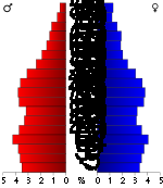 Age pyramid for Jefferson County (as of 2000).[7]
As of the census[8] of 2000, there were 84,278 people, 30,555 households, and 21,510 families residing in the county. The population density was 95 people per square mile (37/km²). There were 34,350 housing units at an average density of 39 per square mile (15/km²). The racial makeup of the county was 49.58% Black or African American, 48.46% White, 0.24% Native American, 0.66% Asian, 0.04% Pacific Islander, 0.26% from other races, and 0.76% from two or more races. 0.96% of the population were Hispanic or Latino of any race. By comparison, the county had 15,714 residents in 1870, 20% of whom were White.[9]
In the county there were 30,555 households out of which 33.10% had children under the age of 18 living with them, 47.40% were married couples living together, 18.80% had a female householder with no husband present, and 29.60% were non-families. 26.20% of all households were made up of individuals and 10.60% had someone living alone who was 65 years of age or older. The average household size was 2.59 and the average family size was 3.13. The population was spread out with 26.30% under the age of 18, 10.80% from 18 to 24, 27.80% from 25 to 44, 22.10% from 45 to 64, and 12.90% who were 65 years of age or older. The median age was 35 years. For every 100 females there were 95.90 males. For every 100 females age 18 and over, there were 93.40 males.
The median income for a household in the county was $31,327, and the median income for a family was $38,252. Males had a median income of $31,848 versus $21,867 for females. The per capita income for the county was $15,417. About 16.00% of families and 20.50% of the population were below the poverty line, including 29.60% of those under age 18 and 17.80% of those age 65 or over.
Government and infrastructure
The Arkansas Department of Correction (ADC) operates its headquarters in Pine Bluff.[10][11] The ADC headquarters moved to the Pine Bluff Complex in 1979.[12] The administrative Annex East is on Harding Avenue in Pine Bluff, south of city hall.[13] The Diagnostic Unit,[14] the Pine Bluff Unit, and the Randall L. Williams Correctional Facility are in the "Pine Bluff Complex" in Pine Bluff.[15][16] The headquarters of the Arkansas Correctional School system are within the Pine Bluff Complex.[16][17]
The Arkansas Department of Correction Maximum Security Unit is 25 miles (40 km) north of central Pine Bluff and off of Arkansas Highway 15 in unincorporated Jefferson County.[18] The Tucker Unit is also located north of Pine Bluff.[19]
The Arkansas Department of Community Correction Southeast Arkansas Community Corrections Center is in Pine Bluff.[20]
Historically the Arkansas Boys' Industrial School and the Arkansas Negro Boys' Industrial School were in the county.[21]
Major highways
 Interstate 530
 U.S. Highway 65
 U.S. Highway 79
 U.S. Highway 270
 U.S. Highway 425
 Highway 15
 Highway 31
 Highway 46
 Highway 58
 Highway 81
 Highway 88
Communities
Cities and towns
Unincorporated areas
- Lake Dick
- Tucker
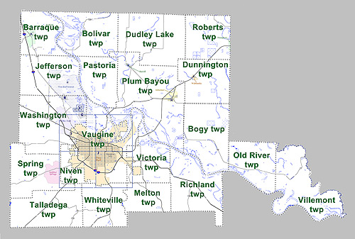
Townships
 Townships in Jefferson County, Arkansas as of 2010
Townships in Arkansas are the divisions of a county. Each township includes unincorporated areas and some may have incorporated towns or cities within part of their space. Townships have limited purposes in modern times. However, the US Census does list Arkansas population based on townships (often referred to as "minor civil divisions"). Townships are also of value for historical purposes in terms of genealogical research. Each town or city is within one or more townships in an Arkansas county based on census maps. The townships of Jefferson County are listed below with the town(s) and/or city that are fully or partially inside them listed in parentheses. [22][23]
- Barraque (Redfield)
- Bogy
- Bolivar
- Dudley Lake
- Dunnington (Wabbaseka)
- Jefferson
- Melton
- Niven
- Old River
- Pastoria
- Plum Bayou (Altheimer, Sherrill)
- Richland
- Roberts (Humphrey)
- Spring
- Talladega
- Vaugine (Pine Bluff)
- Victoria
- Villemont
- Washington (White Hall)
- Whiteville
Adjacent counties

Pulaski County Lonoke County Grant County 
Arkansas County  Jefferson County, Arkansas

Cleveland County Lincoln County See also
Notes
- ^ "Census 2000 U.S. Gazetteer Files: Counties". United States Census. http://www.census.gov/tiger/tms/gazetteer/county2k.txt. Retrieved 2011-02-13.
- ^ JeffCounty 1888, p. 4
- ^ JeffCounty 1888, pp. 15–16
- ^ http://www.census.gov/population/www/censusdata/cencounts/files/ar190090.txt
- ^ http://factfinder2.census.gov
- ^ http://mapserver.lib.virginia.edu/
- ^ Based on 2000 census data[dated info]
- ^ "American FactFinder". United States Census Bureau. http://factfinder.census.gov. Retrieved 2008-01-31.
- ^ JeffCounty 1888, p. 3
- ^ "Pine Bluff city, Arkansas." U.S. Census Bureau. Retrieved on September 7, 2010.
- ^ "Central Office." Arkansas Department of Correction. Retrieved on June 28, 2010.
- ^ "2006 Facts Brochure." Arkansas Department of Correction. July 1, 2005-June 30, 2006. 25 (25/38). Retrieved on August 15, 2010.
- ^ "Facilities." Arkansas Department of Correction. Retrieved on June 28, 2010.
- ^ "Diagnostic Unit." Arkansas Department of Correction. Retrieved on June 28, 2010.
- ^ "Pine Bluff Unit/Randall L. Williams Correctional Facility." Arkansas Department of Correction. Retrieved on June 28, 2010.
- ^ a b "School Sites." Arkansas Correctional School. Retrieved on July 18, 2010.
- ^ "Contact Us." Arkansas Correctional School. Retrieved on July 18, 2010.
- ^ "Maximum Security Unit." Arkansas Department of Correction. Retrieved on June 28, 2010.
- ^ "Pine Bluff Unit/Randall L. Williams Correctional Facility/Tucker Unit." Arkansas Department of Correction. Retrieved on June 28, 2010.
- ^ "Locations." Arkansas Department of Community Corrections. Retrieved on March 5, 2011. "7301 West 13th Street, Pine Bluff, Arkansas 71602"
- ^ "1936 Jefferson County, Arkansas Highway Map." Arkansas State Highway and Transportation Department. Retrieved on September 28, 2011.
- ^ US Census Bureau. 2011 Boundary and Annexation Survey (BAS): Jefferson County, AR (Map). http://www2.census.gov/geo/pvs/bas/bas11/st05_ar/cou/c05069_jefferson/BAS11C20506900000_000.pdf. Retrieved 20110813.
- ^ http://www.census.gov/geo/www/maps/DC10_GUBlkMap/cousub/dc10blk_st05_cousub.html#J
References
- Jefferson County Immigration Bureau (August 1888), Jefferson County, Arkansas: Full Description, Chicago: C.S. Burch Publishing Co., http://books.google.com/books?id=dEhDAAAAYAAJ, retrieved 2011-08-21
External links
- Jefferson County from the Encyclopedia of Arkansas History & Culture
- Pine Bluff/Jefferson County Library System
Municipalities and communities of Jefferson County, Arkansas Cities Altheimer | Humphrey‡ | Pine Bluff | Redfield | Wabbaseka | White Hall

Town CDP Sulphur Springs
Unincorporated
communitiesJefferson | Moscow | Lake Dick | Reydell | Tucker | Wright
Footnotes ‡This populated place also has portions in an adjacent county or counties
 State of Arkansas
Topics - Index
- Arkansans
- Constitution
- Delegations
- Geography
- Government
- Governor (List)
- History
- Images
- Places
- Transportation
- Visitor Attractions
Society - Culture
- Crime
- Demographics
- Economy
- Education
- Politics
Regions Metros Largest cities Other cities Counties - Arkansas
- Ashley
- Baxter
- Benton
- Boone
- Bradley
- Calhoun
- Carroll
- Chicot
- Clark
- Clay
- Cleburne
- Cleveland
- Columbia
- Conway
- Craighead
- Crawford
- Crittenden
- Cross
- Dallas
- Desha
- Drew
- Faulkner
- Franklin
- Fulton
- Garland
- Grant
- Greene
- Hempstead
- Hot Spring
- Howard
- Independence
- Izard
- Jackson
- Jefferson
- Johnson
- Lafayette
- Lawrence
- Lee
- Lincoln
- Little River
- Logan
- Lonoke
- Madison
- Marion
- Miller
- Mississippi
- Monroe
- Montgomery
- Nevada
- Newton
- Ouachita
- Perry
- Phillips
- Pike
- Poinsett
- Polk
- Pope
- Prairie
- Pulaski
- Randolph
- Saline
- Scott
- Searcy
- Sebastian
- Sevier
- Sharp
- St. Francis
- Stone
- Union
- Van Buren
- Washington
- White
- Woodruff
- Yell
Categories:- Arkansas counties
- Jefferson County, Arkansas
- 1829 establishments in the United States
- Populated places established in 1829
- Pine Bluff metropolitan area


Wikimedia Foundation. 2010.