- Mississippi County, Arkansas
-
Mississippi County, Arkansas 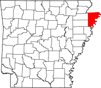
Location in the state of Arkansas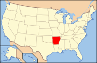
Arkansas's location in the U.S.Founded November 1, 1833 Seat Blytheville and Osceola Area
- Total
- Land
- Water
919.73 sq mi (2,382 km²)
898.25 sq mi (2,326 km²)
21.48 sq mi (56 km²), 2.34%Population
- (2010)
- Density
46,480
52/sq mi (19.98/km²)Congressional district 1st Mississippi County is a county located in the U.S. state of Arkansas. As of 2010, the population was 46,480. There are two county seats, Blytheville and Osceola.[1] The county was formed on November 1, 1833, and named for the Mississippi River which borders the county to the east. Mississippi County is part of the First Congressional District in Arkansas which is the poorest Congressional District in the United States.
The Blytheville Micropolitan Statistical Area includes all of Mississippi County.
Jefferson W. Speck, a Mississippi County planter, was the Republican gubernatorial nominee in 1950 and 1952.
Contents
Geography
According to the 2010 census, the county has a total area of 919.73 square miles (2,382.1 km2), of which 898.25 square miles (2,326.5 km2) (or 97.66%) is land and 21.48 square miles (55.6 km2) (or 2.34%) is water.[2]
List Of Highways
 Interstate 55
 U.S. Highway 61
 Highway 14
 Highway 18
 Highway 18 Business
 Highway 77
 Highway 118
 Highway 119
 Highway 135
 Highway 136
 Highway 137
 Highway 137 Spur
 Highway 140
 Highway 150
 Highway 151
 Highway 158
 Highway 181
 Highway 239
 Highway 239 Spur
 Highway 947
Adjacent counties
- Dunklin County, Missouri (northwest)
- Pemiscot County, Missouri (north)
- Dyer County, Tennessee (northeast)
- Lauderdale County, Tennessee (east)
- Tipton County, Tennessee (southeast)
- Crittenden County (south)
- Poinsett County (southwest)
- Craighead County (west)
See also: List of counties bordering eight or more countiesNational protected area
Demographics
Historical populations Census Pop. %± 1840 1,410 — 1850 2,368 67.9% 1860 3,895 64.5% 1870 3,633 −6.7% 1880 7,332 101.8% 1890 11,635 58.7% 1900 16,384 40.8% 1910 30,468 86.0% 1920 47,320 55.3% 1930 69,289 46.4% 1940 80,217 15.8% 1950 82,375 2.7% 1960 70,174 −14.8% 1970 62,060 −11.6% 1980 59,517 −4.1% 1990 57,525 −3.3% 2000 51,979 −9.6% 2010 46,480 −10.6% [3][4][5]  Age pyramid Mississippi County[6]
As of the census[7] of 2000, there were 51,979 people, 19,349 households, and 13,911 families residing in the county. The population density was 58 people per square mile (22/km²). There were 22,310 housing units at an average density of 25 per square mile (10/km²). The racial makeup of the county was 64.45% White, 32.70% Black or African American, 0.26% Native American, 0.38% Asian, 0.03% Pacific Islander, 1.07% from other races, and 1.12% from two or more races. 2.25% of the population were Hispanic or Latino of any race.
There were 19,349 households out of which 36.00% had children under the age of 18 living with them, 50.00% were married couples living together, 17.40% had a female householder with no husband present, and 28.10% were non-families. 24.70% of all households were made up of individuals and 10.70% had someone living alone who was 65 years of age or older. The average household size was 2.64 and the average family size was 3.15.
In the county the population was spread out with 29.60% under the age of 18, 9.90% from 18 to 24, 27.50% from 25 to 44, 20.80% from 45 to 64, and 12.20% who were 65 years of age or older. The median age was 33 years. For every 100 females there were 91.80 males. For every 100 females age 18 and over, there were 87.70 males.
The median income for a household in the county was $27,479, and the median income for a family was $32,648. Males had a median income of $29,645 versus $19,782 for females. The per capita income for the county was $13,978. About 19.00% of families and 23.00% of the population were below the poverty line, including 31.10% of those under age 18 and 19.80% of those age 65 or over.
Cities and towns
Townships
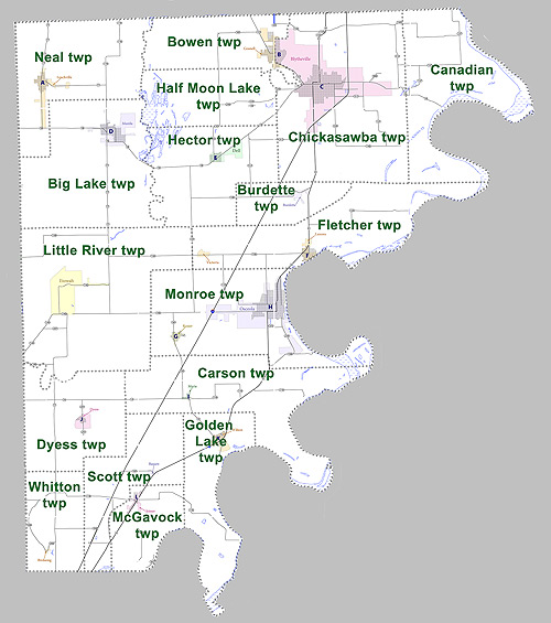
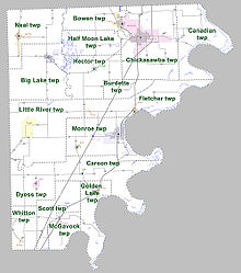 Townships in Mississippi County, Arkansas as of 2010
Townships in Arkansas are the divisions of a county. Each township includes unincorporated areas and some may have incorporated towns or cities within part of their space. Townships have limited purposes in modern times. However, the US Census does list Arkansas population based on townships (often referred to as "minor civil divisions"). Townships are also of value for historical purposes in terms of genealogical research. Each town or city is within one or more townships in an Arkansas county based on census maps. The townships of Mississippi County are listed below with the town(s) and/or city that are fully or partially inside them listed in parentheses. [8][9]
- Big Lake (Manila)
- Bowen (Gosnell)
- Burdette (Burdette)
- Canadian
- Carson (Marie)
- Chickasawba (Blytheville)
- Dyess (Dyess)
- Fletcher (Luxora, Victoria)
- Golden Lake (Wilson)
- Half Moon Lake
- Hector (Dell)
- Little River
- McGavock (Joiner)
- Monroe (Keiser, Osceola)
- Neal (Leachville)
- Scott (Bassett)
- Whitton (Birdsong)
See also
References
- ^ "Find a County". National Association of Counties. http://www.naco.org/Counties/Pages/FindACounty.aspx. Retrieved 2011-06-07.
- ^ "Census 2000 U.S. Gazetteer Files: Counties". United States Census. http://www.census.gov/tiger/tms/gazetteer/county2k.txt. Retrieved 2011-02-13.
- ^ http://www.census.gov/population/www/censusdata/cencounts/files/ar190090.txt
- ^ http://factfinder2.census.gov
- ^ http://mapserver.lib.virginia.edu/
- ^ Based on 2000 census data
- ^ "American FactFinder". United States Census Bureau. http://factfinder.census.gov. Retrieved 2008-01-31.
- ^ US Census Bureau. 2011 Boundary and Annexation Survey (BAS): Mississippi County, AR (Map). http://www2.census.gov/geo/pvs/bas/bas11/st05_ar/cou/c05093_mississippi/BAS11C20509300000_000.pdf. Retrieved 20110819.
- ^ http://www.census.gov/geo/www/maps/DC10_GUBlkMap/cousub/dc10blk_st05_cousub.html#M
Municipalities and communities of Mississippi County, Arkansas Cities Blytheville | Gosnell | Joiner | Keiser | Leachville | Manila | Osceola

Towns Unincorporated
communitiesArkmo‡ | Athelstan | Creamery Package | Denwood | Dimple | Driver | Floodway | Frenchmans Bayou | Poplar Corner | Turner | West Ridge
Footnotes ‡This populated place also has portions in an adjacent county or counties
 State of Arkansas
Topics - Index
- Arkansans
- Constitution
- Delegations
- Geography
- Government
- Governor (List)
- History
- Images
- Places
- Transportation
- Visitor Attractions
Society - Culture
- Crime
- Demographics
- Economy
- Education
- Politics
Regions Metros Largest cities Other cities Counties - Arkansas
- Ashley
- Baxter
- Benton
- Boone
- Bradley
- Calhoun
- Carroll
- Chicot
- Clark
- Clay
- Cleburne
- Cleveland
- Columbia
- Conway
- Craighead
- Crawford
- Crittenden
- Cross
- Dallas
- Desha
- Drew
- Faulkner
- Franklin
- Fulton
- Garland
- Grant
- Greene
- Hempstead
- Hot Spring
- Howard
- Independence
- Izard
- Jackson
- Jefferson
- Johnson
- Lafayette
- Lawrence
- Lee
- Lincoln
- Little River
- Logan
- Lonoke
- Madison
- Marion
- Miller
- Mississippi
- Monroe
- Montgomery
- Nevada
- Newton
- Ouachita
- Perry
- Phillips
- Pike
- Poinsett
- Polk
- Pope
- Prairie
- Pulaski
- Randolph
- Saline
- Scott
- Searcy
- Sebastian
- Sevier
- Sharp
- St. Francis
- Stone
- Union
- Van Buren
- Washington
- White
- Woodruff
- Yell
Coordinates: 35°46′36″N 90°03′16″W / 35.77667°N 90.05444°W
Categories:- Arkansas counties
- Mississippi County, Arkansas
- 1833 establishments in the United States
- Populated places established in 1833
- Arkansas counties on the Mississippi River


Wikimedia Foundation. 2010.