- Drew County, Arkansas
-
Drew County, Arkansas 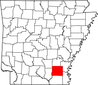
Location in the state of Arkansas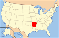
Arkansas's location in the U.S.Founded November 26, 1846 Named for Thomas Drew, the 3rd governor of Arkansas Seat Monticello Largest city Monticello Area
- Total
- Land
- Water
835.65 sq mi (2,164 km²)
828.18 sq mi (2,145 km²)
7.47 sq mi (19 km²), 0.89%Population
- (2010)
- Density
18,509
22/sq mi (8.6/km²)Time zone Central: UTC-6/-5 Drew County is a county located in the U.S. state of Arkansas. As of 2010, the population was 18,509. The county seat is Monticello. Drew County was formed on November 26, 1846, and named for Thomas Drew, the 3rd governor of Arkansas.
Contents
Geography
According to the 2000 census, the county has a total area of 835.65 square miles (2,164.3 km2), of which 828.18 square miles (2,145.0 km2) (or 99.11%) is land and 7.47 square miles (19.3 km2) (or 0.89%) is water.[1]
Loggy Bayou is a swamp in Drew County, not to be confused with a bayou in northwestern Louisiana, also called Loggy Bayou.
Major highways
 U.S. Highway 165
 U.S. Highway 278
 U.S. Highway 425
 Highway 4
 Highway 8
 Highway 35
 Highway 133
 Highway 530
Adjacent counties
- Lincoln County (north)
- Desha County (northeast)
- Chicot County (southeast)
- Ashley County (south)
- Bradley County (west)
- Cleveland County (northwest)
Demographics
Historical populations Census Pop. %± 1850 3,276 — 1860 9,078 177.1% 1870 9,960 9.7% 1880 12,231 22.8% 1890 17,352 41.9% 1900 19,451 12.1% 1910 21,960 12.9% 1920 21,822 −0.6% 1930 19,928 −8.7% 1940 19,831 −0.5% 1950 17,959 −9.4% 1960 15,213 −15.3% 1970 15,157 −0.4% 1980 17,910 18.2% 1990 17,369 −3.0% 2000 18,723 7.8% 2010 18,509 −1.1% [2][3][4] 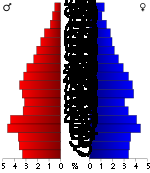 Age pyramid Drew County[5]
As of the census[6] of 2000, there were 18,723 people, 7,337 households, and 5,091 families residing in the county. The population density was 23 people per square mile (9/km²). There were 8,287 housing units at an average density of 10 per square mile (4/km²). The racial makeup of the county was 70.30% White, 27.16% Black or African American, 0.25% Native American, 0.42% Asian, 0.02% Pacific Islander, 1.00% from other races, and 0.85% from two or more races. 1.76% of the population were Hispanic or Latino of any race.
There were 7,337 households out of which 33.50% had children under the age of 18 living with them, 51.30% were married couples living together, 14.20% had a female householder with no husband present, and 30.60% were non-families. 26.00% of all households are made and 10.50% had someone living alone who was 65 years of age or older. The average household size was 2.46 and the average family size was 2.97.
In the county the population was spread out with 25.80% under the age of 18, 12.60% from 18 to 24, 27.20% from 25 to 44, 21.50% from 45 to 64, and 12.80% who were 65 years of age or older. The median age was 34 years. For every 100 females there were 94.10 males. For every 100 females age 18 and over, there were 91.50 males.
The median income for a household in the county was $28,627, and the median income for a family was $37,317. Males had a median income of $30,794 versus $20,707 for females. The per capita income for the county was $16,264. About 13.10% of families and 18.20% of the population were below the poverty line, including 21.90% of those under age 18 and 21.80% of those age 65 or over.
Cities and towns
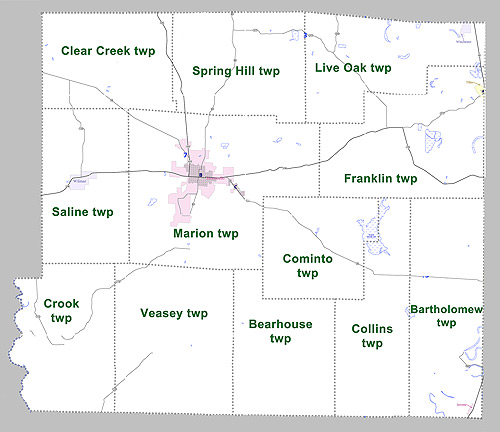
Townships
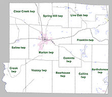 Townships in Drew County, Arkansas as of 2010
Townships in Arkansas are the divisions of a county. Each township includes unincorporated areas and some may have incorporated towns or cities within part of their space. Townships have limited purposes in modern times. However, the US Census does list Arkansas population based on townships (often referred to as "minor civil divisions"). Townships are also of value for historical purposes in terms of genealogical research. Each town or city is within one or more townships in an Arkansas county based on census maps. The townships of Drew County are listed below with the town(s) and/or city that are fully or partially inside them listed in parentheses. [7][8]
- Bartholomew (Jerome)
- Bearhouse
- Clear Creek
- Collins
- Cominto
- Crook
- Franklin (Tillar)
- Live Oak (Winchester)
- Marion (Monticello)
- Saline (Wilmar)
- Spring Hill
- Veasey
See also
References
- ^ "Census 2000 U.S. Gazetteer Files: Counties". United States Census. http://www.census.gov/tiger/tms/gazetteer/county2k.txt. Retrieved 2011-02-13.
- ^ http://www.census.gov/population/www/censusdata/cencounts/files/ar190090.txt
- ^ http://factfinder2.census.gov
- ^ http://mapserver.lib.virginia.edu/
- ^ Based on 2000 census data
- ^ "American FactFinder". United States Census Bureau. http://factfinder.census.gov. Retrieved 2008-01-31.
- ^ US Census Bureau. 2011 Boundary and Annexation Survey (BAS): Drew County, AR (Map). http://www2.census.gov/geo/pvs/bas/bas11/st05_ar/cou/c05043_drew/BAS11C20504300000_000.pdf. Retrieved 20110807.
- ^ http://www.census.gov/geo/www/maps/DC10_GUBlkMap/cousub/dc10blk_st05_cousub.html#D

Cleveland County Lincoln County Desha County Bradley County 
 Drew County, Arkansas

Ashley County Chicot County Municipalities and communities of Drew County, Arkansas Cities Jerome | Monticello | Tillar‡ | Wilmar | Winchester

Footnotes ‡This populated place also has portions in an adjacent county or counties
 State of Arkansas
Topics - Index
- Arkansans
- Constitution
- Delegations
- Geography
- Government
- Governor (List)
- History
- Images
- Places
- Transportation
- Visitor Attractions
Society - Culture
- Crime
- Demographics
- Economy
- Education
- Politics
Regions Metros Largest cities Other cities Counties - Arkansas
- Ashley
- Baxter
- Benton
- Boone
- Bradley
- Calhoun
- Carroll
- Chicot
- Clark
- Clay
- Cleburne
- Cleveland
- Columbia
- Conway
- Craighead
- Crawford
- Crittenden
- Cross
- Dallas
- Desha
- Drew
- Faulkner
- Franklin
- Fulton
- Garland
- Grant
- Greene
- Hempstead
- Hot Spring
- Howard
- Independence
- Izard
- Jackson
- Jefferson
- Johnson
- Lafayette
- Lawrence
- Lee
- Lincoln
- Little River
- Logan
- Lonoke
- Madison
- Marion
- Miller
- Mississippi
- Monroe
- Montgomery
- Nevada
- Newton
- Ouachita
- Perry
- Phillips
- Pike
- Poinsett
- Polk
- Pope
- Prairie
- Pulaski
- Randolph
- Saline
- Scott
- Searcy
- Sebastian
- Sevier
- Sharp
- St. Francis
- Stone
- Union
- Van Buren
- Washington
- White
- Woodruff
- Yell
Coordinates: 33°35′04″N 91°43′51″W / 33.58444°N 91.73083°W
Categories:- Arkansas counties
- 1846 establishments in the United States
- Drew County, Arkansas


Wikimedia Foundation. 2010.