- Desha County, Arkansas
-
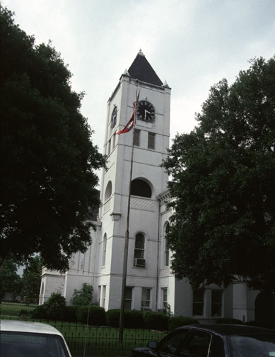
Desha County, Arkansas 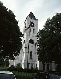 Desha County courthouse in Arkansas City, Arkansas
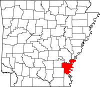
Location in the state of Arkansas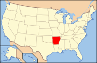
Arkansas's location in the U.S.Founded December 12, 1838 Seat Arkansas City Area
- Total
- Land
- Water
819.52 sq mi (2,123 km²)
764.99 sq mi (1,981 km²)
54.53 sq mi (141 km²), 6.65%Population
- (2010)
- Density
13,008
17/sq mi (6.6/km²)Desha County (
 /dəˈʃeɪ/) is a county located in the U.S. state of Arkansas. As of the 2010 census, the population was 13,008.[1] The county seat is Arkansas City. Desha County is Arkansas's 40th county, formed on December 12, 1838, and named for Captain Benjamin Desha who fought in the War of 1812.[2]
Contents
Geography
According to the U.S. Census Bureau, the county has a total area of 819.52 square miles (2,122.5 km2), of which 764.99 square miles (1,981.3 km2) (or 93.35%) is land and 54.53 square miles (141.2 km2) (or 6.65%) is water.[3] Desha County is alternately considered as part of the larger regions of South Arkansas and Southeast Arkansas.
Major highways
 U.S. Highway 65
 U.S. Highway 165
 U.S. Highway 278
 Highway 1
 Highway 4
Adjacent counties
- Arkansas County (north)
- Phillips County (northeast)
- Bolivar County, Mississippi (east)
- Chicot County (south)
- Drew County (southwest)
- Lincoln County (northwest)
National protected area
Demographics
Historical populations Census Pop. %± 1840 1,598 — 1850 2,911 82.2% 1860 6,459 121.9% 1870 6,125 −5.2% 1880 8,973 46.5% 1890 10,324 15.1% 1900 11,511 11.5% 1910 15,274 32.7% 1920 20,297 32.9% 1930 21,814 7.5% 1940 27,160 24.5% 1950 25,155 −7.4% 1960 20,770 −17.4% 1970 18,761 −9.7% 1980 19,760 5.3% 1990 16,798 −15.0% 2000 15,341 −8.7% 2010 13,008 −15.2% [4][5][6] 
As of the census[8] of 2000, there were 15,341 people, 5,922 households, and 4,192 families residing in the county. The population density was 20 people per square mile (8/km²). There were 6,663 housing units at an average density of 9 per square mile (3/km²). The racial makeup of the county was 50.50% White, 46.33% Black or African American, 0.35% Native American, 0.30% Asian, 0.03% Pacific Islander, 1.73% from other races, and 0.76% from two or more races. 3.16% of the population were Hispanic or Latino of any race.
There were 5,922 households out of which 34.60% had children under the age of 18 living with them, 46.50% were married couples living together, 19.90% had a female householder with no husband present, and 29.20% were non-families. 26.90% of all households were made up of individuals and 12.70% had someone living alone who was 65 years of age or older. The average household size was 2.57 and the average family size was 3.10.
In the county the population was spread out with 28.90% under the age of 18, 9.00% from 18 to 24, 25.20% from 25 to 44, 22.70% from 45 to 64, and 14.20% who were 65 years of age or older. The median age was 36 years. For every 100 females there were 87.60 males. For every 100 females age 18 and over, there were 82.90 males.
The median income for a household in the county was $24,121, and the median income for a family was $30,028. Males had a median income of $29,623 versus $18,913 for females. The per capita income for the county was $13,446. About 23.60% of families and 28.90% of the population were below the poverty line, including 39.60% of those under age 18 and 24.00% of those age 65 or over.
Cities and towns
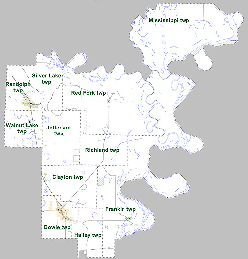
Townships
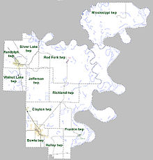 Townships in Desha County, Arkansas as of 2010
Townships in Arkansas are the divisions of a county. Each township includes unincorporated areas and some may have incorporated towns or cities within part of their space. Townships have limited purposes in modern times. However, the US Census does list Arkansas population based on townships (often referred to as "minor civil divisions"). Townships are also of value for historical purposes in terms of genealogical research. Each town or city is within one or more townships in an Arkansas county based on census maps. The townships of Desha County are listed below with the town(s) and/or city that are fully or partially inside them listed in parentheses. [9][10]
- Bowie (most of McGehee)
- Clayton (Reed, Tillar, small part of McGehee)
- Franklin (Arkansas City)
- Halley (small part of McGehee)
- Jefferson
- Mississippi
- Randolph (Mitchellville, most of Dumas)
- Red Fork (Watson)
- Richland
- Silver Lake
- Walnut Lake
Notable people
- Garland E. Bayliss
- Ken Coon
- John "Kayo" Dottley
- Jim Hines
- John H. Johnson
- Major Jones
- Doug Terry
See also
References
- ^ "Race, Hispanic or Latino, Age, and Housing Occupancy: 2010 Census Redistricting Data (Public Law 94-171) Summary File (QT-PL), Desha County, Arkansas". U.S. Census Bureau, American FactFinder 2. http://factfinder2.census.gov. Retrieved August 12, 2011.
- ^ "Desha County". Encyclopedia of Arkansas History & Culture. The Central Arkansas Library System. 2009. http://www.encyclopediaofarkansas.net/encyclopedia/entry-detail.aspx?entryID=765. Retrieved 2009-02-16.
- ^ "Census 2000 U.S. Gazetteer Files: Counties". United States Census. http://www.census.gov/tiger/tms/gazetteer/county2k.txt. Retrieved 2011-02-13.
- ^ http://www.census.gov/population/www/censusdata/cencounts/files/ar190090.txt
- ^ http://factfinder2.census.gov
- ^ http://mapserver.lib.virginia.edu/
- ^ Based on 2000 census data
- ^ "American FactFinder". United States Census Bureau. http://factfinder.census.gov. Retrieved 2008-01-31.
- ^ US Census Bureau. 2011 Boundary and Annexation Survey (BAS): Desha County, AR (Map). http://www2.census.gov/geo/pvs/bas/bas11/st05_ar/cou/c05041_desha/BAS11C20504100000_000.pdf. Retrieved 20110821.
- ^ http://www.census.gov/geo/www/maps/DC10_GUBlkMap/cousub/dc10blk_st05_cousub.html#D

Lincoln County Arkansas County Phillips County 
Bolivar County, Mississippi  Desha County, Arkansas

Drew County Chicot County Municipalities and communities of Desha County, Arkansas Cities Arkansas City | Dumas | McGehee | Mitchellville | Tillar‡ | Watson

Town Unincorporated
communitiesBack Gate | Halley | Kelso | Pea Ridge | Pickens | Rohwer | Snow Lake | Trippe Junction
Ghost towns Napoleon | Wellington
Footnotes ‡This populated place also has portions in an adjacent county or counties
 State of Arkansas
Topics - Index
- Arkansans
- Constitution
- Delegations
- Geography
- Government
- Governor (List)
- History
- Images
- Places
- Transportation
- Visitor Attractions
Society - Culture
- Crime
- Demographics
- Economy
- Education
- Politics
Regions Metros Largest cities Other cities Counties - Arkansas
- Ashley
- Baxter
- Benton
- Boone
- Bradley
- Calhoun
- Carroll
- Chicot
- Clark
- Clay
- Cleburne
- Cleveland
- Columbia
- Conway
- Craighead
- Crawford
- Crittenden
- Cross
- Dallas
- Desha
- Drew
- Faulkner
- Franklin
- Fulton
- Garland
- Grant
- Greene
- Hempstead
- Hot Spring
- Howard
- Independence
- Izard
- Jackson
- Jefferson
- Johnson
- Lafayette
- Lawrence
- Lee
- Lincoln
- Little River
- Logan
- Lonoke
- Madison
- Marion
- Miller
- Mississippi
- Monroe
- Montgomery
- Nevada
- Newton
- Ouachita
- Perry
- Phillips
- Pike
- Poinsett
- Polk
- Pope
- Prairie
- Pulaski
- Randolph
- Saline
- Scott
- Searcy
- Sebastian
- Sevier
- Sharp
- St. Francis
- Stone
- Union
- Van Buren
- Washington
- White
- Woodruff
- Yell
Coordinates: 33°45′28″N 91°17′14″W / 33.75778°N 91.28722°W
Categories:- Arkansas counties
- Desha County, Arkansas
- 1838 establishments in the United States
- Populated places established in 1838
- Arkansas counties on the Mississippi River


Wikimedia Foundation. 2010.