- National Register of Historic Places listings in Desha County, Arkansas
-
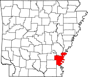
 Location of Desha County in Arkansas
This is a list of the National Register of Historic Places listings in Desha County, Arkansas.
This is intended to be a complete list of the properties and districts on the National Register of Historic Places in Desha County, Arkansas, United States. The locations of National Register properties and districts for which the latitude and longitude coordinates are included below, may be seen in a Google map.[1]
There are 24 properties and districts listed on the National Register in the county, including 1 National Historic Landmark.
Contents: Counties in Arkansas Arkansas - Ashley - Baxter - Benton - Boone - Bradley - Calhoun - Carroll - Chicot - Clark - Clay - Cleburne - Cleveland - Columbia - Conway - Craighead - Crawford - Crittenden - Cross - Dallas - Desha - Drew - Faulkner - Franklin - Fulton - Garland - Grant - Greene - Hempstead - Hot Spring - Howard - Independence - Izard - Jackson - Jefferson - Johnson - Lafayette - Lawrence - Lee - Lincoln - Little River - Logan - Lonoke - Madison - Marion - Miller - Mississippi - Monroe - Montgomery - Nevada - Newton - Ouachita - Perry - Phillips - Pike - Poinsett - Polk - Pope - Prairie - Pulaski (Little Rock) - Randolph - St. Francis - Saline - Scott - Searcy - Sebastian - Sevier - Sharp - Stone - Union - Van Buren - Washington - White - Woodruff - Yell
-
- This National Park Service list is complete through NPS recent listings posted November 10, 2011.[2]
Current listings
[3] Landmark name [4] Image Date listed Location City or town Summary 1 Arkansas City Commercial District February 18, 1999 Roughly along the junction of Desoto Ave. and Sprague St.
33°36′19″N 91°12′13″W / 33.605278°N 91.203611°WArkansas City 2 Arkansas City High School October 4, 1984 Robert S. Moore and President Sts.
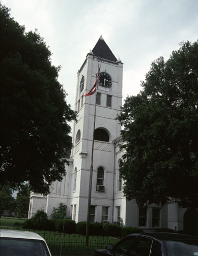
33°36′36″N 91°12′05″W / 33.61°N 91.201389°WArkansas City 3 Desha County Courthouse 
July 12, 1976 Robert S. Moore Ave.
33°36′33″N 91°12′08″W / 33.609167°N 91.202222°WArkansas City 4 Dickinson-Moore House February 1, 2011 707 Robert S. Moore Ave.
33°36′31″N 91°12′10″W / 33.608611°N 91.202778°WArkansas City 5 Dumas Commercial Historic District May 22, 2007 S. Main St. between Choctaw and Waterman Sts.
33°53′22″N 91°29′32″W / 33.889444°N 91.492222°WDumas 6 Hubert & Ionia Furr House February 4, 2011 702 Desoto Ave.
33°36′24″N 91°12′04″W / 33.606667°N 91.201111°WArkansas City 7 Kemp Cotton Gin Historic District June 1, 2005 County Road 227 west of Highway 1
33°45′48″N 91°16′36″W / 33.763333°N 91.276667°WRohwer 8 Jay Lewis House January 20, 2005 12 Fairview Dr.
33°38′13″N 91°24′33″W / 33.636944°N 91.409167°WMcGehee 9 McGehee City Jail January 21, 2011 Southwest corner of S. First St. and Pine St.
33°37′37″N 91°23′45″W / 33.626944°N 91.395833°WMcGehee 10 McGehee National Guard Armory May 31, 2006 1610 S. 1st St.
33°36′48″N 91°23′04″W / 33.613333°N 91.384444°WMcGehee 11 McGehee Post Office January 19, 2010 201 N. Second St.
33°37′44″N 91°23′50″W / 33.628858°N 91.397089°WMcGehee 12 McKennon-Shea House June 8, 1993 206 Waterman St.
33°53′13″N 91°29′39″W / 33.886944°N 91.494167°WDumas 13 Merchants & Farmers Bank December 22, 1982 Waterman and Main Sts.
33°53′15″N 91°29′29″W / 33.8875°N 91.491389°WDumas 14 Missouri-Pacific Railroad Depot-McGehee June 11, 1992 Railroad St.
33°37′42″N 91°23′42″W / 33.628333°N 91.395°WMcGehee 15 Missouri Pacific Railway Van Noy Eating House January 24, 2011 Southeast of the Seamans Dr. and Railroad St. intersection
33°37′41″N 91°23′42″W / 33.628056°N 91.395°WMcGehee 16 Mound Cemetery January 24, 2008 0.5 miles north of Arkansas City on County Road 351
33°37′13″N 91°12′03″W / 33.620278°N 91.200833°WArkansas City 17 Parnell-Sharpe House September 28, 1989 302 N. 2nd St.
33°37′51″N 91°23′52″W / 33.630833°N 91.397778°WMcGehee 18 Xenophon Overton Pindall Law Office May 10, 1999 Junction of Capitol and Kate Adams Sts.
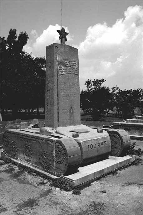
33°36′22″N 91°12′11″W / 33.606111°N 91.203056°WArkansas City 19 Rohwer Relocation Center Memorial Cemetery 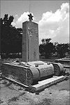
July 6, 1992 Highway 1
33°45′59″N 91°16′49″W / 33.766389°N 91.280278°WRohwer 20 Rohwer Relocation Center Site July 30, 1974 Highway 1
33°46′22″N 91°16′51″W / 33.772778°N 91.280833°WRohwer 21 Temple Meir Chayim April 22, 1999 Junction of 4th and Holly Sts.
33°37′43″N 91°23′59″W / 33.628611°N 91.399722°WMcGehee 22 Thane House December 22, 1982 Levy and 1st Sts.
33°36′26″N 91°11′59″W / 33.607222°N 91.199722°WArkansas City 23 Trippe Holly Grove Cemetery June 25, 1999 Highway 4 or Crooked Bayou Rd., approximately 2 miles south of McGehee
33°36′07″N 91°20′53″W / 33.601944°N 91.348056°WMcGehee 24 Dr. J.D. Watts House December 9, 1994 205 W. Choctaw
33°53′17″N 91°29′39″W / 33.888056°N 91.494167°WDumas See also
- List of National Historic Landmarks in Arkansas
- National Register of Historic Places listings in Arkansas
References
- ^ The latitude and longitude information provided in this table was derived originally from the National Register Information System, which has been found to be fairly accurate for about 99% of listings. For about 1% of NRIS original coordinates, experience has shown that one or both coordinates are typos or otherwise extremely far off; some corrections may have been made. A more subtle problem causes many locations to be off by up to 150 yards, depending on location in the country: most NRIS coordinates were derived from tracing out latitude and longitudes off of USGS topographical quadrant maps created under the North American Datum of 1927, which differs from the current, highly accurate WGS84 GPS system used by Google maps. Chicago is about right, but NRIS longitudes in Washington are higher by about 4.5 seconds, and are lower by about 2.0 seconds in Maine. Latitudes differ by about 1.0 second in Florida. Some locations in this table may have been corrected to current GPS standards.
- ^ "National Register of Historic Places: Weekly List Actions". National Park Service, United States Department of the Interior. Retrieved on November 10, 2011.
- ^ Numbers represent an ordering by significant words. Various colorings, defined here, differentiate National Historic Landmark sites and National Register of Historic Places Districts from other NRHP buildings, structures, sites or objects.
- ^ "National Register Information System". National Register of Historic Places. National Park Service. . http://nrhp.focus.nps.gov/natreg/docs/All_Data.html.
U.S. National Register of Historic Places Topics Lists by states Alabama • Alaska • Arizona • Arkansas • California • Colorado • Connecticut • Delaware • Florida • Georgia • Hawaii • Idaho • Illinois • Indiana • Iowa • Kansas • Kentucky • Louisiana • Maine • Maryland • Massachusetts • Michigan • Minnesota • Mississippi • Missouri • Montana • Nebraska • Nevada • New Hampshire • New Jersey • New Mexico • New York • North Carolina • North Dakota • Ohio • Oklahoma • Oregon • Pennsylvania • Rhode Island • South Carolina • South Dakota • Tennessee • Texas • Utah • Vermont • Virginia • Washington • West Virginia • Wisconsin • WyomingLists by territories Lists by associated states Other Municipalities and communities of Desha County, Arkansas Cities Arkansas City | Dumas | McGehee | Mitchellville | Tillar‡ | Watson
Town Unincorporated
communitiesBack Gate | Halley | Kelso | Pea Ridge | Pickens | Rohwer | Snow Lake | Trippe Junction
Ghost towns Napoleon | Wellington
Footnotes ‡This populated place also has portions in an adjacent county or counties
Categories:- Desha County, Arkansas
- National Register of Historic Places in Arkansas by county
-

Wikimedia Foundation. 2010.