- National Register of Historic Places listings in Miller County, Arkansas
-
 Location of Miller County in Arkansas
This is a list of the National Register of Historic Places listings in Miller County, Arkansas.
This is intended to be a complete list of the properties and districts on the National Register of Historic Places in Miller County, Arkansas, United States. The locations of National Register properties and districts for which the latitude and longitude coordinates are included below, may be seen in a Google map.[1]
There are 33 properties and districts listed on the National Register in the county.
Contents: Counties in Arkansas Arkansas - Ashley - Baxter - Benton - Boone - Bradley - Calhoun - Carroll - Chicot - Clark - Clay - Cleburne - Cleveland - Columbia - Conway - Craighead - Crawford - Crittenden - Cross - Dallas - Desha - Drew - Faulkner - Franklin - Fulton - Garland - Grant - Greene - Hempstead - Hot Spring - Howard - Independence - Izard - Jackson - Jefferson - Johnson - Lafayette - Lawrence - Lee - Lincoln - Little River - Logan - Lonoke - Madison - Marion - Miller - Mississippi - Monroe - Montgomery - Nevada - Newton - Ouachita - Perry - Phillips - Pike - Poinsett - Polk - Pope - Prairie - Pulaski (Little Rock) - Randolph - St. Francis - Saline - Scott - Searcy - Sebastian - Sevier - Sharp - Stone - Union - Van Buren - Washington - White - Woodruff - Yell
-
- This National Park Service list is complete through NPS recent listings posted November 10, 2011.[2]
Current listings
[3] Landmark name [4] Image Date listed Location City or town Summary 1 Wallace Adams Service Station August 1, 2008 52 E. 23rd St.
33°26′39″N 94°02′17″W / 33.444258°N 94.03795°WTexarkana 2 Patrick J. Ahern House January 20, 2005 403 Laurel St.
33°25′35″N 94°02′23″W / 33.426389°N 94.039722°WTexarkana 3 Averitt House July 24, 1992 Western side of U.S. Route 71, 6 miles south of Texarkana
33°20′50″N 93°57′51″W / 33.347222°N 93.964167°WMount Pleasant 4 Beech Street Brick Street May 22, 2007 Beech St. between 14th and 24th Sts.
33°26′50″N 94°02′21″W / 33.447222°N 94.039167°WTexarkana 5 Beech Street Historic District January 21, 2010 Roughly Beech St. between 14th and 23rd Sts.
33°26′26″N 94°02′22″W / 33.440553°N 94.039325°WTexarkana 6 Bottoms House June 8, 1982 500 Hickory
33°25′44″N 94°02′05″W / 33.428889°N 94.034722°WTexarkana 7 Buhrman-Pharr Hardware Company Historic District September 24, 2004 610 and 620 E 3rd St.
33°25′36″N 94°02′15″W / 33.426667°N 94.0375°WTexarkana 8 Canaan Baptist Church June 14, 1990 Junction of Laurel and 10th Sts.
33°25′59″N 94°02′29″W / 33.433056°N 94.041389°WTexarkana 9 John Clifton House June 2, 2000 1803 Pecan St.
33°26′23″N 94°02′14″W / 33.439722°N 94.037222°WTexarkana 10 Confederate Section-Old Rondo Cemetery September 22, 2004 1612 Smith Rd.
33°26′47″N 93°58′03″W / 33.446389°N 93.9675°WRondo 11 Cotton Belt Railroad Office Building August 1, 2008 312 E. Broad St.
33°25′21″N 94°02′26″W / 33.422469°N 94.040561°WTexarkana 12 Crenshaw Site January 26, 1994 Address Restricted Hervey 13 Dean House December 12, 1976 1520 Beech St.
33°26′19″N 94°02′19″W / 33.438611°N 94.038611°WTexarkana 14 East Broad Street Historic District August 1, 2008 100 block of E. Broad St.
33°25′18″N 94°02′32″W / 33.421639°N 94.042358°WTexarkana 15 Claude Foulke House April 22, 1982 501 Pecan St.
33°25′41″N 94°02′09″W / 33.428056°N 94.035833°WTexarkana 16 Augustus M. Garrison House March 25, 1982 600 Pecan St.
33°25′45″N 94°02′11″W / 33.429167°N 94.036389°WTexarkana 17 Hopkins Feed and Seed Store August 1, 2008 301 E. 3rd St.
33°25′24″N 94°02′29″W / 33.423364°N 94.041339°WTexarkana 18 Kiblah School November 20, 1989 Route 1
33°03′12″N 93°52′01″W / 33.053333°N 93.866944°WDoddridge 19 Kittrell House December 22, 1982 1103 Hickory St.
33°26′01″N 94°02′11″W / 33.433611°N 94.036389°WTexarkana 20 Miller County Courthouse May 29, 1998 400 Laurel St.
33°25′35″N 94°01′38″W / 33.426389°N 94.027222°WTexarkana 21 Mullins Court January 29, 2007 605 Hickory St.
33°25′53″N 94°02′08″W / 33.431389°N 94.035556°WTexarkana 22 Charles J. Neif House August 5, 1994 1410 Pecan St.
33°26′12″N 94°02′13″W / 33.436667°N 94.036944°WTexarkana 23 Old Arkansas 2-Mayton Segment May 16, 2008 County Roads 122 and 123
33°23′43″N 93°44′40″W / 33.395142°N 93.744517°WGarland Part of Arkansas Highway 2 24 Old US 67, Mandeville January 21, 2004 Highway 296, County Road 138, and southeast of the current U.S. Route 67
33°29′16″N 93°57′35″W / 33.487778°N 93.959722°WMandeville 25 Orr School July 30, 1976 831 Laurel St.
33°25′48″N 94°02′31″W / 33.43°N 94.041944°WTexarkana 26 Ritchie Grocery Building June 14, 1990 Junction of Front and Olive Sts.
33°25′15″N 94°02′29″W / 33.420833°N 94.041389°WTexarkana 27 Swift Building August 1, 2008 410 E. Broad St.
33°25′23″N 94°02′22″W / 33.422956°N 94.039486°WTexarkana 28 Texarkana Union Station November 19, 1978 State Line and Front St.
33°25′12″N 94°02′33″W / 33.42°N 94.0425°WTexarkana 29 Texarkana US Post Office and Courthouse 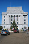
March 24, 2000 5th St. and State Line Ave.
33°25′30″N 94°02′34″W / 33.425°N 94.042778°WTexarkana Extends into Bowie County, Texas 30 Texarkana, Arkansas, Municipal Building January 21, 2004 Walnut and 3rd Sts.
33°25′25″N 94°02′22″W / 33.423611°N 94.039444°WTexarkana 31 J.K. Wadley House February 12, 1999 618 Pecan St.
33°25′47″N 94°02′11″W / 33.429722°N 94.036389°WTexarkana 32 Alvah Horace Whitmarsh House August 29, 1980 711 Pecan St.
33°25′57″N 94°02′26″W / 33.4325°N 94.040556°WTexarkana 33 Wynn-Price House January 23, 1992 Price St.
33°21′48″N 93°43′24″W / 33.363333°N 93.723333°WGarland See also
- List of National Historic Landmarks in Arkansas
- National Register of Historic Places listings in Arkansas
References
- ^ The latitude and longitude information provided in this table was derived originally from the National Register Information System, which has been found to be fairly accurate for about 99% of listings. For about 1% of NRIS original coordinates, experience has shown that one or both coordinates are typos or otherwise extremely far off; some corrections may have been made. A more subtle problem causes many locations to be off by up to 150 yards, depending on location in the country: most NRIS coordinates were derived from tracing out latitude and longitudes off of USGS topographical quadrant maps created under the North American Datum of 1927, which differs from the current, highly accurate WGS84 GPS system used by Google maps. Chicago is about right, but NRIS longitudes in Washington are higher by about 4.5 seconds, and are lower by about 2.0 seconds in Maine. Latitudes differ by about 1.0 second in Florida. Some locations in this table may have been corrected to current GPS standards.
- ^ "National Register of Historic Places: Weekly List Actions". National Park Service, United States Department of the Interior. Retrieved on November 10, 2011.
- ^ Numbers represent an ordering by significant words. Various colorings, defined here, differentiate National Historic Landmark sites and National Register of Historic Places Districts from other NRHP buildings, structures, sites or objects.
- ^ "National Register Information System". National Register of Historic Places. National Park Service. . http://nrhp.focus.nps.gov/natreg/docs/All_Data.html.
U.S. National Register of Historic Places Topics Lists by states Alabama • Alaska • Arizona • Arkansas • California • Colorado • Connecticut • Delaware • Florida • Georgia • Hawaii • Idaho • Illinois • Indiana • Iowa • Kansas • Kentucky • Louisiana • Maine • Maryland • Massachusetts • Michigan • Minnesota • Mississippi • Missouri • Montana • Nebraska • Nevada • New Hampshire • New Jersey • New Mexico • New York • North Carolina • North Dakota • Ohio • Oklahoma • Oregon • Pennsylvania • Rhode Island • South Carolina • South Dakota • Tennessee • Texas • Utah • Vermont • Virginia • Washington • West Virginia • Wisconsin • WyomingLists by territories Lists by associated states Other Municipalities and communities of Miller County, Arkansas City 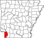
Towns Unincorporated
communitiesDoddridge | Genoa | Mandeville
Categories:- Miller County, Arkansas
- National Register of Historic Places in Arkansas by county
-


Wikimedia Foundation. 2010.