- National Register of Historic Places listings in Lonoke County, Arkansas
-
 Location of Lonoke County in Arkansas
This is a list of the National Register of Historic Places listings in Lonoke County, Arkansas.
This is intended to be a complete list of the properties and districts on the National Register of Historic Places in Lonoke County, Arkansas, United States. The locations of National Register properties and districts for which the latitude and longitude coordinates are included below, may be seen in a Google map.[1]
There are 30 properties and districts listed on the National Register in the county, including 1 National Historic Landmark. Another property was once listed but has been removed.
Contents: Counties in Arkansas Arkansas - Ashley - Baxter - Benton - Boone - Bradley - Calhoun - Carroll - Chicot - Clark - Clay - Cleburne - Cleveland - Columbia - Conway - Craighead - Crawford - Crittenden - Cross - Dallas - Desha - Drew - Faulkner - Franklin - Fulton - Garland - Grant - Greene - Hempstead - Hot Spring - Howard - Independence - Izard - Jackson - Jefferson - Johnson - Lafayette - Lawrence - Lee - Lincoln - Little River - Logan - Lonoke - Madison - Marion - Miller - Mississippi - Monroe - Montgomery - Nevada - Newton - Ouachita - Perry - Phillips - Pike - Poinsett - Polk - Pope - Prairie - Pulaski (Little Rock) - Randolph - St. Francis - Saline - Scott - Searcy - Sebastian - Sevier - Sharp - Stone - Union - Van Buren - Washington - White - Woodruff - Yell
-
- This National Park Service list is complete through NPS recent listings posted November 10, 2011.[2]
Current listings
[3] Landmark name [4] Image Date listed Location City or town Summary 1 Ashley-Alexander House June 18, 1976 North of Scott
34°42′21″N 92°05′33″W / 34.705833°N 92.0925°WScott 2 Thomas Sloan Boyd House January 1, 1976 220 Park Ave.
34°46′55″N 91°54′07″W / 34.781944°N 91.901944°WLonoke 3 Camp Nelson Confederate Cemetery May 3, 1996 Rye St., approximately 1 mile northwest of the junction of Highways 319 and 321
34°56′46″N 91°58′49″W / 34.946111°N 91.980278°WCabot 4 Carlisle Rock Island Depot June 14, 1990 Junction of Main St. and Court Ave.
34°46′58″N 91°44′46″W / 34.782778°N 91.746111°WCarlisle 5 Carver Gymnasium September 23, 2009 400 Ferguson St.
34°46′51″N 91°53′47″W / 34.780875°N 91.896497°WLonoke 6 Coy Mound Site September 22, 1995 Address Restricted Coy 7 Dortch Plantation December 6, 1975 Northeast of Scott off Highway 130 at Bearskin Lake
34°42′55″N 92°03′13″W / 34.715278°N 92.053611°WScott 8 Eagle House December 22, 1982 217 Ash St.
34°46′57″N 91°54′06″W / 34.7825°N 91.901667°WLonoke 9 Joe P. Eagle and D.R. Boone Building December 9, 1994 105-107 W. Front St.
34°47′01″N 91°54′01″W / 34.783611°N 91.900278°WLonoke 10 First Christian Church July 9, 1997 Junction of 2nd and Depot Sts.
34°47′07″N 91°54′04″W / 34.785278°N 91.901111°WLonoke 11 First Presbyterian Church September 23, 2004 304 S. Center St.
34°46′53″N 91°54′01″W / 34.781389°N 91.900278°WLonoke 12 W.P. Fletcher House September 5, 1990 604 W. 4th St.
34°47′14″N 91°54′19″W / 34.787222°N 91.905278°WLonoke 13 Keo Commercial Historic District June 15, 2011 Main & Fleming Sts., Arkansas Highway 232
34°36′02″N 92°00′33″W / 34.600556°N 92.009167°WKeo Cotton and Rice Farm History and Architecture in the Arkansas Delta MPS 14 Lonoke Confederate Monument May 3, 1996 On the courthouse lawn, near the junction of 3rd and Center Sts.
34°47′09″N 91°53′58″W / 34.785833°N 91.899444°WLonoke 15 Lonoke County Courthouse June 8, 1982 N. Center St.
34°47′09″N 91°53′57″W / 34.785833°N 91.899167°WLonoke 16 Lonoke Downtown Historic District 
May 10, 1996 Junction of Front and Center Sts.
34°47′05″N 91°53′58″W / 34.784722°N 91.899444°WLonoke 17 Memphis to Little Rock Road-Bayou Two Prairie Segment September 20, 2006 Address Restricted Brownsville A segment of the Trail of Tears 18 Memphis to Little Rock Road-Brownsville Segment September 27, 2003 Address Restricted Brownsville A segment of the Trail of Tears 19 Rock Island Depot October 4, 1984 U.S. Route 70 and Center St.
34°47′02″N 91°54′02″W / 34.783889°N 91.900556°WLonoke 20 Sears House August 5, 1992 Southeast of the junction of Highways 38 and 319
34°59′05″N 91°57′43″W / 34.984722°N 91.961944°WAustin 21 Shull House December 22, 1982 418 Park
34°46′48″N 91°54′05″W / 34.78°N 91.901389°WLonoke 22 Toltec Mounds 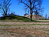
January 12, 1973 Address Restricted Scott 23 Trimble House December 22, 1982 518 Center St.
34°46′46″N 91°53′59″W / 34.779444°N 91.899722°WLonoke 24 Trimble-McCrary House September 24, 2004 516 Jefferson
34°46′45″N 91°54′10″W / 34.779167°N 91.902778°WLonoke 25 US 70, Union Valley Segment September 23, 2004 North and south of U.S. Route 70 from the S28/S29 boundary line R9W west to the S26/S27 boundary line R10W
34°45′56″N 92°01′25″W / 34.765556°N 92.023611°WUnion Valley 26 Dr. E.F. Utley House June 3, 1998 401 W. Pine St.
35°00′43″N 92°01′04″W / 35.011944°N 92.017778°WCabot 27 Walls Farm Barn and Corn Crib November 29, 1995 Highway 31 north of Tomberlin
34°31′26″N 91°52′26″W / 34.523889°N 91.873889°WTomberlin 28 Walls House December 22, 1982 406 Jefferson St.
34°46′49″N 91°54′12″W / 34.780278°N 91.903333°WLonoke 29 Wheat House December 22, 1982 600 Center St.
34°46′43″N 91°53′59″W / 34.778611°N 91.899722°WLonoke 30 Woodlawn School Building February 25, 1993 Northwest of the junction of Highway 31 and Bizzell Rd.
34°55′22″N 91°52′30″W / 34.922778°N 91.875°WWoodlawn Former listing
Landmark name Image Date Location City or Town Summary 1 St. Louis Southwest Railway (Cotton Belt Route) Depot January 23, 2008 (delisted) Main St. (Highway 31) Coy See also
- List of National Historic Landmarks in Arkansas
- National Register of Historic Places listings in Arkansas
References
- ^ The latitude and longitude information provided in this table was derived originally from the National Register Information System, which has been found to be fairly accurate for about 99% of listings. For about 1% of NRIS original coordinates, experience has shown that one or both coordinates are typos or otherwise extremely far off; some corrections may have been made. A more subtle problem causes many locations to be off by up to 150 yards, depending on location in the country: most NRIS coordinates were derived from tracing out latitude and longitudes off of USGS topographical quadrant maps created under North American Datum of 1927, which differs from the current, highly accurate GPS system used by Google maps. Chicago is about right, but NRIS longitudes in Washington are higher by about 4.5 seconds, and are lower by about 2.0 seconds in Maine. Latitudes differ by about 1.0 second in Florida. Some locations in this table may have been corrected to current GPS standards.
- ^ "National Register of Historic Places: Weekly List Actions". National Park Service, United States Department of the Interior. Retrieved on November 10, 2011.
- ^ Numbers represent an ordering by significant words. Various colorings, defined here, differentiate National Historic Landmark sites and National Register of Historic Places Districts from other NRHP buildings, structures, sites or objects.
- ^ "National Register Information System". National Register of Historic Places. National Park Service. . http://nrhp.focus.nps.gov/natreg/docs/All_Data.html.
U.S. National Register of Historic Places Topics Lists by states Alabama • Alaska • Arizona • Arkansas • California • Colorado • Connecticut • Delaware • Florida • Georgia • Hawaii • Idaho • Illinois • Indiana • Iowa • Kansas • Kentucky • Louisiana • Maine • Maryland • Massachusetts • Michigan • Minnesota • Mississippi • Missouri • Montana • Nebraska • Nevada • New Hampshire • New Jersey • New Mexico • New York • North Carolina • North Dakota • Ohio • Oklahoma • Oregon • Pennsylvania • Rhode Island • South Carolina • South Dakota • Tennessee • Texas • Utah • Vermont • Virginia • Washington • West Virginia • Wisconsin • WyomingLists by territories Lists by associated states Other  Category:National Register of Historic Places •
  Portal:National Register of Historic Places
Municipalities and communities of Lonoke County, Arkansas County seat: Lonoke Cities 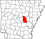
Towns CDP Townships Butler | Carlisle | Caroline | Cleveland | Crooked Creek | Dortch | Eagle | Fletcher | Furlow | Goodrum | Gray | Gum Woods | Hamilton | Indian Bayou | Isbell | Lafayette | Lonoke | Magness | Oak Grove | Pettus | Prairie | Pulaski | Richwoods | Scott | Totten | Walls | Ward | Williams | York
Unincorporated
communitiesBayou Meto | Bethlehem | Bevis Corner | Blakemore | Butlerville | Furlow | Mountain Springs | Ryan | Sylvania | Tomberlin | Woodlawn
Footnotes ‡This populated place also has portions in an adjacent county or counties
Categories:- Lonoke County, Arkansas
- National Register of Historic Places in Arkansas by county
-


Wikimedia Foundation. 2010.