- National Register of Historic Places listings in Clark County, Arkansas
-
 Location of Clark County in Arkansas
This is a list of the National Register of Historic Places listings in Clark County, Arkansas.
This is intended to be a complete list of the properties on the National Register of Historic Places in Clark County, Arkansas, United States. The locations of National Register properties for which the latitude and longitude coordinates are included below, may be seen in a Google map.[1]
There are 41 properties listed on the National Register in the county. Another property was once listed but has been removed.
Contents: Counties in Arkansas Arkansas - Ashley - Baxter - Benton - Boone - Bradley - Calhoun - Carroll - Chicot - Clark - Clay - Cleburne - Cleveland - Columbia - Conway - Craighead - Crawford - Crittenden - Cross - Dallas - Desha - Drew - Faulkner - Franklin - Fulton - Garland - Grant - Greene - Hempstead - Hot Spring - Howard - Independence - Izard - Jackson - Jefferson - Johnson - Lafayette - Lawrence - Lee - Lincoln - Little River - Logan - Lonoke - Madison - Marion - Miller - Mississippi - Monroe - Montgomery - Nevada - Newton - Ouachita - Perry - Phillips - Pike - Poinsett - Polk - Pope - Prairie - Pulaski (Little Rock) - Randolph - St. Francis - Saline - Scott - Searcy - Sebastian - Sevier - Sharp - Stone - Union - Van Buren - Washington - White - Woodruff - Yell
-
- This National Park Service list is complete through NPS recent listings posted November 10, 2011.[2]
Current listings
[3] Landmark name [4] Image Date listed Location City or town Summary 1 Arkadelphia Boy Scout Hut January 28, 2002 8th St.
34°07′45″N 93°03′16″W / 34.129167°N 93.054444°WArkadelphia 2 Arkadelphia Commercial Historic District July 20, 2011 Roughly Main St. between 5th & 7th Sts., & Clinton St between 6th & 9th Sts.
34°07′12″N 93°03′13″W / 34.12°N 93.053611°WArkadelphia 3 Arkadelphia Confederate Monument May 3, 1996 Courthouse lawn, near the southeastern corner of the junction of 6th and Caddo Sts.
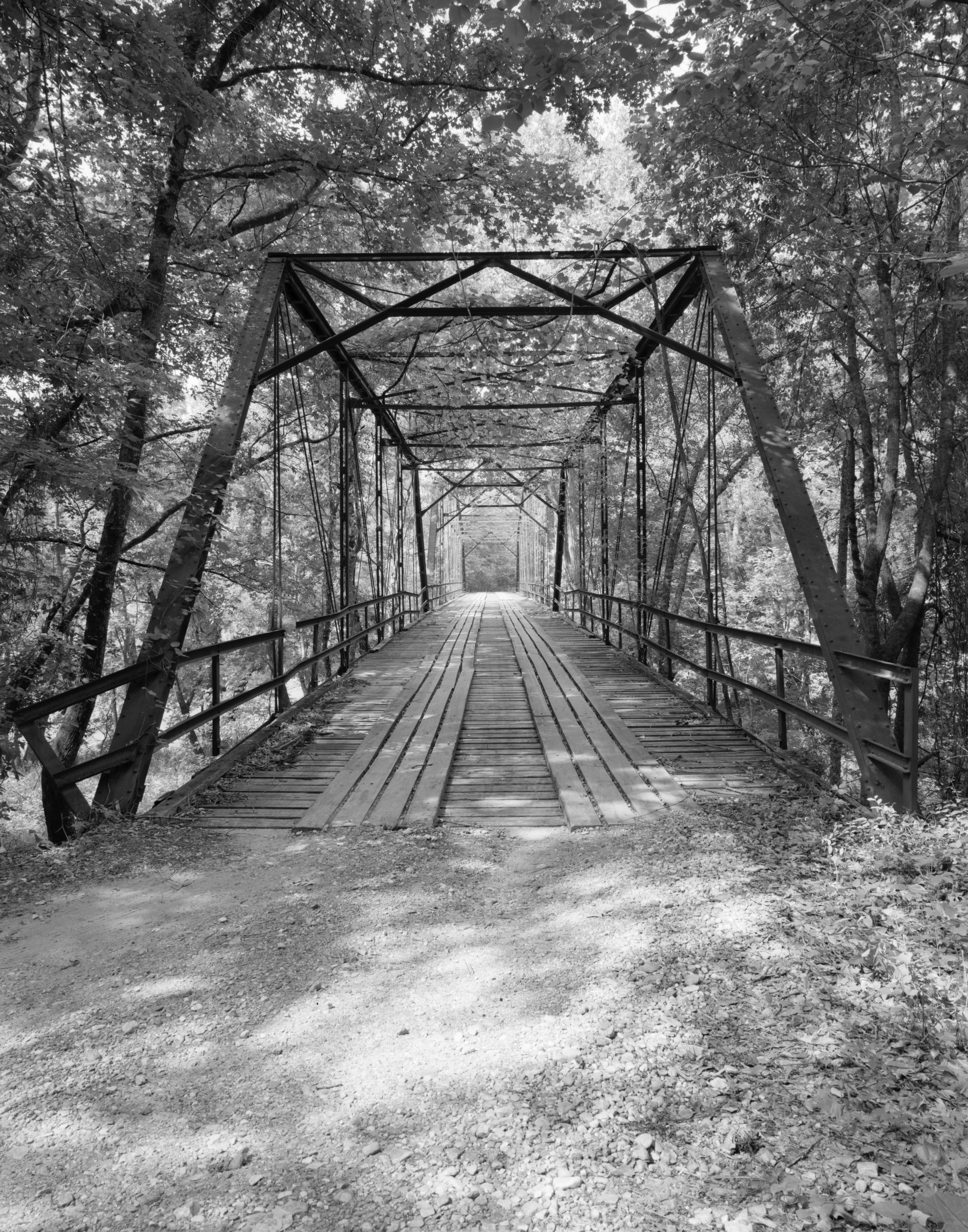
34°07′12″N 93°03′03″W / 34.12°N 93.050833°WArkadelphia 4 Arkansas 7/51 Bridge February 1, 2006 Highways 7 and 51
34°07′23″N 93°02′47″W / 34.123056°N 93.046389°WArkadelphia 5 James E. M. Barkman House July 30, 1974 406 N. 10th St.
34°07′31″N 93°03′22″W / 34.125278°N 93.056111°WArkadelphia 6 Bayou Sel September 10, 1974 Address Restricted Arkadelphia 7 Nannie Gresham Biscoe House January 21, 2004 227 Cherry St.
34°07′22″N 93°02′57″W / 34.122778°N 93.049167°WArkadelphia 8 Dr. Boaz House January 28, 1992 Highway 26
34°04′23″N 93°22′19″W / 34.073056°N 93.371944°WClear Spring 9 Bozeman House November 14, 1978 West of Arkadelphia on Highway 26
34°05′44″N 93°09′03″W / 34.095556°N 93.150833°WArkadelphia 10 Clark County Courthouse December 1, 1978 4th and Crittenden Sts.
34°07′06″N 93°03′03″W / 34.118333°N 93.050833°WArkadelphia 11 Clark County Library November 5, 1974 609 Caddo St.
34°07′14″N 93°03′15″W / 34.120556°N 93.054167°WArkadelphia 12 Clear Springs Tabernacle February 13, 1992 Junction of Highway 26 and Bobo Rd.
34°03′23″N 93°23′31″W / 34.056389°N 93.391944°WOkolona 13 Domestic Science Building December 22, 1982 11th and Haddock
34°06′19″N 93°03′35″W / 34.105278°N 93.059722°WArkadelphia 14 DeGray Creek Bridge January 21, 2010 County Road 50 over DeGray Creek
34°09′37″N 93°11′21″W / 34.160411°N 93.189214°WArkadelphia 15 Elkins' Ferry April 19, 1994 Both banks of the Little Missouri River, about 10 miles north of Prescott
33°56′09″N 93°21′12″W / 33.935833°N 93.353333°WPrescott Site of the Civil War Battle of Elkin's Ferry; one of the Camden Expedition Sites, a National Historic Landmark consisting of sites in several counties; extends into Nevada County 16 Horace Estes House September 21, 1993 614 E. Main St.
33°55′00″N 93°08′48″W / 33.916667°N 93.146667°WGurdon 17 Flanagin Law Office December 22, 1977 320 Clay St.
34°07′08″N 93°03′03″W / 34.118889°N 93.050833°WArkadelphia 18 Gurdon Jail November 13, 1989 W. Joslyn and Front Sts.
33°55′11″N 93°09′14″W / 33.919722°N 93.153889°WGurdon 19 Habicht-Cohn-Crow House October 3, 1985 8th and Pine
34°07′21″N 93°03′21″W / 34.1225°N 93.055833°WArkadelphia 20 Capt. Charles C. Henderson House August 24, 1998 Junction of 10th and Henderson Sts.
34°07′12″N 93°03′25″W / 34.12°N 93.056944°WArkadelphia 21 Hoo Hoo Monument September 2, 1999 1st St.
33°55′13″N 93°09′14″W / 33.920278°N 93.153889°WGurdon 22 Hudson-Jones House September 30, 1982 East of Arkadelphia on Highway 2
34°04′11″N 92°56′33″W / 34.069722°N 92.9425°WArkadelphia 23 Loy Kirksey House February 3, 1992 County Road 59 west of De Gray Lake
34°14′02″N 93°17′45″W / 34.233889°N 93.295833°WFendley 24 Little Missouri River Bridge 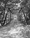
April 9, 1990 County Road 179, over the Little Missouri River
33°54′10″N 93°18′35″W / 33.902778°N 93.309722°WPrescott 25 Magnolia Manor September 27, 1972 0.6 miles southwest of the junction of Interstate 30 and Highway 51
34°06′44″N 93°06′20″W / 34.112222°N 93.105556°WArkadelphia 26 McNeely Creek Bridge May 26, 2004 County Road 12
33°53′20″N 93°12′34″W / 33.888889°N 93.209444°WBeirne 27 Missouri-Pacific Railroad Depot-Arkadelphia June 11, 1992 S. 5th St.
34°07′05″N 93°03′09″W / 34.118136°N 93.052453°WArkadelphia 28 Missouri-Pacific Railroad Depot-Gurdon June 11, 1992 Northwest of the junction of N. 1st and E. Walnut Sts.
33°55′14″N 93°09′07″W / 33.920556°N 93.151944°WGurdon 29 Okolona Colored High School Gymnasium September 23, 2011 767 Layne St.
33°59′35″N 93°20′23″W / 33.993056°N 93.339722°WOkolona 30 Old Arkansas 51, Curtis to Gum Springs January 21, 2004 West of U.S. Route 67, starting approximately 0.5 miles south of the junction of U.S. Route 67 and Curtis Cemetery Rd., and ending at its junction with Highway 26
34°01′58″N 93°06′18″W / 34.032778°N 93.105°WCurtis 31 Old Bank of Amity June 5, 1991 Northwestern corner of the town square
34°15′55″N 93°27′40″W / 34.265278°N 93.461111°WAmity 32 Old US 67 Rest Area October 5, 2006 Western side of Old U.S. Route 67, approx. 0.5 miles south of Middleton
34°01′12″N 93°06′35″W / 34.02°N 93.109722°WCurtis 33 Peake High School January 19, 2005 1600 Caddo St.
34°07′17″N 93°04′03″W / 34.121389°N 93.0675°WArkadelphia 34 Ronoake Baptist Church September 23, 2011 North end of Ronoake Baptist Church Rd. Gurdon vicinity 35 Rose Hill Cemetery February 1, 1999 1200 block of Main St.
34°07′07″N 93°03′41″W / 34.118611°N 93.061389°WArkadelphia 36 Rosedale Plantation Barn January 21, 2004 879 Old Military Rd.
34°09′41″N 93°06′07″W / 34.161389°N 93.101944°WArkadelphia 37 Ross Site (3CL401) October 10, 1985 Address Restricted Whelen Springs 38 June Sandidge House February 25, 1993 811 Cherry St.
33°55′21″N 93°08′41″W / 33.9225°N 93.144722°WGurdon 39 C. E. Thompson General Store and House April 4, 2001 3100 Hollywood
34°07′03″N 93°05′49″W / 34.1175°N 93.096944°WArkadelphia 40 US 67 Bridge over Little Missouri River January 24, 2007 U.S. Route 67
33°52′48″N 93°18′16″W / 33.88°N 93.304444°WPrescott 41 W. H. Young House September 20, 2006 316 Meador Ln.
34°07′32″N 93°02′21″W / 34.125556°N 93.039167°WArkadelphia Former listing
Landmark name Image Dates Location City or Town Summary 1 Cobb-Weber House January 26, 2006 (delisted) Arkadelphia See also
- List of National Historic Landmarks in Arkansas
- National Register of Historic Places listings in Arkansas
References
- ^ The latitude and longitude information provided in this table was derived originally from the National Register Information System, which has been found to be fairly accurate for about 99% of listings. For about 1% of NRIS original coordinates, experience has shown that one or both coordinates are typos or otherwise extremely far off; some corrections may have been made. A more subtle problem causes many locations to be off by up to 150 yards, depending on location in the country: most NRIS coordinates were derived from tracing out latitude and longitudes off of USGS topographical quadrant maps created under North American Datum of 1927, which differs from the current, highly accurate GPS system used by Google maps. Chicago is about right, but NRIS longitudes in Washington are higher by about 4.5 seconds, and are lower by about 2.0 seconds in Maine. Latitudes differ by about 1.0 second in Florida. Some locations in this table may have been corrected to current GPS standards.
- ^ "National Register of Historic Places: Weekly List Actions". National Park Service, United States Department of the Interior. Retrieved on November 10, 2011.
- ^ Numbers represent an ordering by significant words. Various colorings, defined here, differentiate National Historic Landmark sites and National Register of Historic Places Districts from other NRHP buildings, structures, sites or objects.
- ^ "National Register Information System". National Register of Historic Places. National Park Service. . http://nrhp.focus.nps.gov/natreg/docs/All_Data.html.
U.S. National Register of Historic Places Topics Lists by states Alabama • Alaska • Arizona • Arkansas • California • Colorado • Connecticut • Delaware • Florida • Georgia • Hawaii • Idaho • Illinois • Indiana • Iowa • Kansas • Kentucky • Louisiana • Maine • Maryland • Massachusetts • Michigan • Minnesota • Mississippi • Missouri • Montana • Nebraska • Nevada • New Hampshire • New Jersey • New Mexico • New York • North Carolina • North Dakota • Ohio • Oklahoma • Oregon • Pennsylvania • Rhode Island • South Carolina • South Dakota • Tennessee • Texas • Utah • Vermont • Virginia • Washington • West Virginia • Wisconsin • WyomingLists by territories Lists by associated states Other  Category:National Register of Historic Places •
  Portal:National Register of Historic Places
Municipalities and communities of Clark County, Arkansas County seat: Arkadelphia Cities Amity | Arkadelphia | Gurdon

Towns Unincorporated
communitiesCategories:- Clark County, Arkansas
- National Register of Historic Places in Arkansas by county
-

Wikimedia Foundation. 2010.