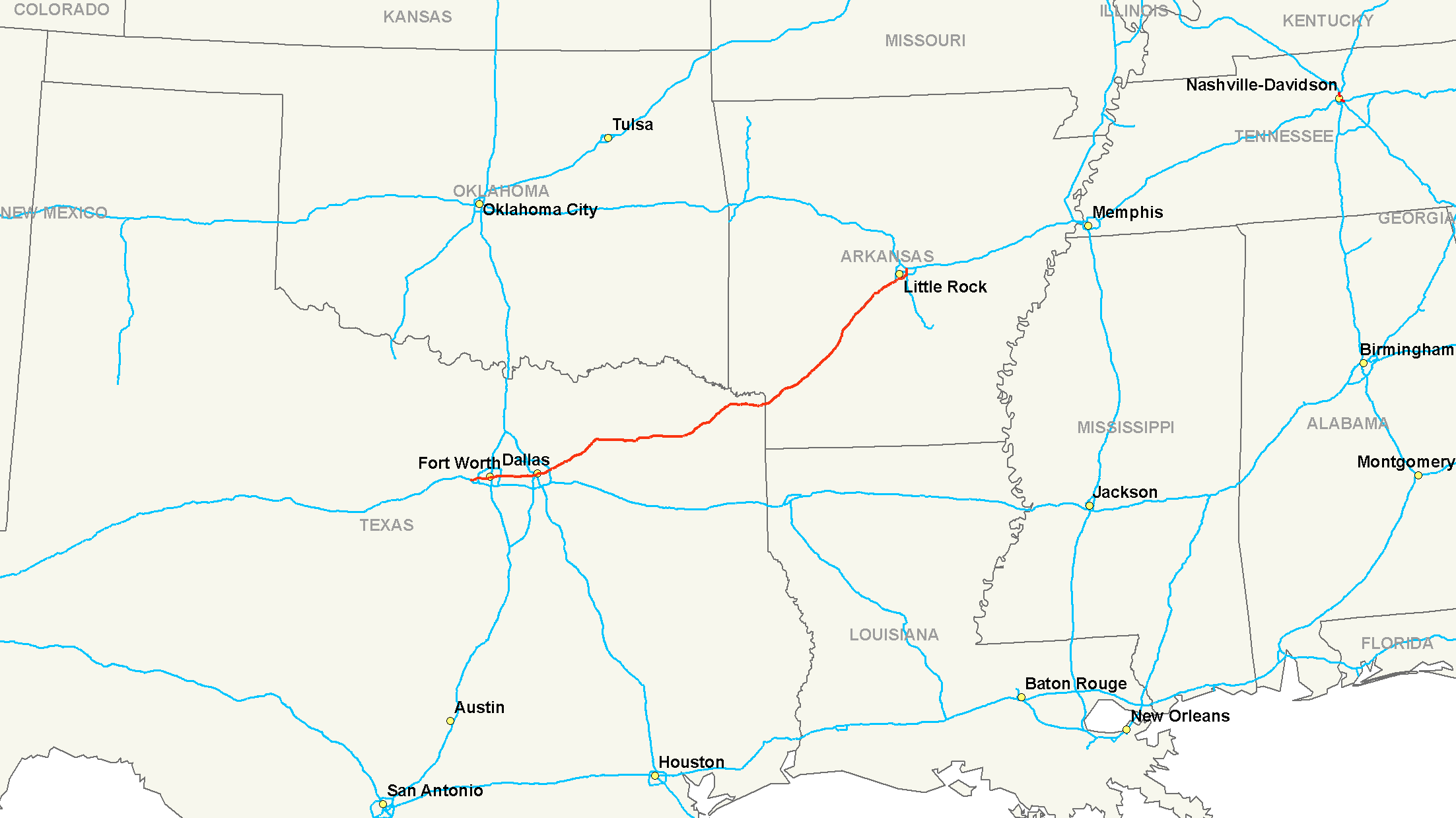
- Interstate 30
-
"I-30" redirects here. For other uses, see I-30 (disambiguation).
Interstate 30

Route information Length: 366.76 mi[1] (590.24 km) Major junctions West end:  I-20 near Fort Worth, TX
 I-35W in Fort Worth, TX
 I-35E in Dallas, TX
 I-45 in Dallas, TX
East end: 


 I-40 / U.S. 65 / U.S. 67 / U.S. 167 in North Little Rock, AR
Location States: Texas, Arkansas Highway system Main route of the Interstate Highway System
Main • Auxiliary • BusinessInterstate 30 (I-30) is an Interstate Highway in the southern United States. I-30 runs from Interstate 20 west of Fort Worth, Texas, northeast via Dallas, Texas, and Texarkana, Texas, to Interstate 40 in North Little Rock, Arkansas. The route parallels U.S. Route 67 except for the portion west of downtown Dallas (which was once part of Interstate 20).[2] I-30 intersects with only two of the 10 primary north–south interstates (I-35W, I-35E and I-45) and also with the major Interstate routes I-20, and I-40.
Contents
Route description
Lengths mi[1] km TX 223.74 360.07 AR 143.02 230.17 Total 366.76 590.24 Interstate 30 is the shortest two-digit Interstate ending in zero in the Interstate system. The Interstates ending in 0 are generally the longest east–west Interstates. It is also the second shortest major interstate (ending in 0 or 5), behind Interstate 45.
Texas
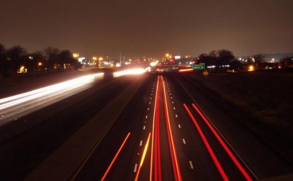
 Tom Landry Freeway @ Eastchase in Fort Worth, Texas
The section of I-30 between Dallas and Fort Worth is designated the Tom Landry Highway in honor of the long-time Dallas Cowboys coach. Though I-30 passes well south of Texas Stadium, the Cowboys' former home, their new stadium in Arlington, Texas is near I-30. However, the freeway designation was made before Arlington voted to build Cowboys Stadium. This section was previously known as the Dallas-Fort Worth Turnpike, which preceded the Interstate system. Although tolls had not been collected for many years, it was still known locally as the Dallas-Fort Worth Turnpike until receiving its present name.[2] The section from Downtown Dallas to Arlington was recently widened to over 16 lanes in some sections, by 2010. From June 15, 2010, through February 6, 2011, this 30-mile section of I-30 was temporarily designated as the "Tom Landry Super Bowl Highway" in commemoration of Super Bowl XLV which was played at Cowboys Stadium.[3]
In Dallas, I-30 is known as East R.L. Thornton Freeway between Downtown Dallas and the eastern suburb of Mesquite. I-30 picks up the name from I-35E South at the Mixmaster interchange. The section from Downtown Dallas to Loop 12 is 8 lanes plus an HOV. This section will be reconstructed under the Eastern Gateway project to 12 lanes by 2020. I-30 from I-635 to Rockwall was widened from 6 to 10 lanes in the 1990s.
Arkansas
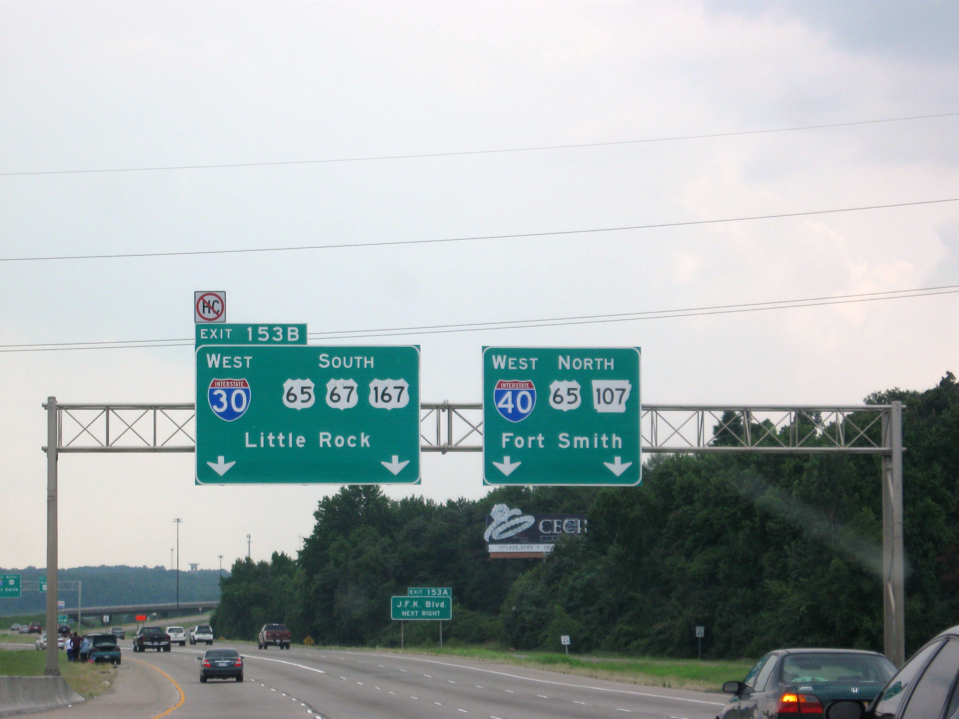
 I-30 begins its 366-mile journey to Dallas here at I-40 in North Little Rock.
I-30 enters southwestern Arkansas in Texarkana which is the twin city of Texarkana, Texas. Here, I-30 will eventually intersect Interstate 49 should it be expanded north into Arkansas or even to Kansas City. Like in Texas, I-30 travels in a diagonal direction as it proceeds north east through the state. I-30 then passes through Hope which is where former President Bill Clinton was born. I-30 then serves Prescott, Gurdon, Arkadelphia, and Malvern. At Malvern, drivers can use U.S. Route 70 or U.S. Route 270 to travel into historic Hot Springs or beyond into Ouachita National Forest. About at this location, U.S. 70 and U.S. 67 join I-30 and stay with the interstate into the Little Rock city limits. Northeast of Malvern, I-30 passes through Benton, before reaching the Little Rock city limits. From Benton to its end at I-40, I-30 is a six-lane highway with up to 85,000 vehicles per day. As I-30 enters Little Rock, Interstate 430 spurns off its parent route to create a western bypass of Little Rock. Just south of downtown, I-30 meets the western terminus of Interstate 440 and the northern terminus of another auxiliary route in Interstate 530. I-530 travels 46 miles south to Pine Bluff. At this tri-intersection of interstates, I-30 turns due north for the final few miles of its route. Here I-30 passes through the capitol district of Little Rock. I-30 also creates one final auxiliary route in Interstate 630, or the Wilbur D. Mills Freeway, which splits downtown Little Rock in an east/west direction before coming to its other end at I-430 just west of downtown. After passing I-630, I-30 crosses the Arkansas River into North Little Rock and comes to its eastern terminus, despite facing north, at Interstate 40. At its end, I-30 is joined by U.S. Route 65, U.S. Route 67, and U.S. Route 167. U.S. 65 joins I-40 westbound, while U.S. 67 and 167 join I-40 eastbound from I-30's eastern terminus.
History
The Dallas-Fort Worth Turnpike was a 30-mile (48 km) toll highway in the Dallas-Fort Worth Metroplex. It operated between 1957 and 1977, afterward becoming a nondescript part of I-30. The road, three lanes in each direction but later widened, is the only direct connection between downtown Fort Worth and downtown Dallas, Texas. In October 2001, the former turnpike became known as the Tom Landry Highway, named after the late Dallas Cowboys coach Tom Landry.
The proposed expressway was studied as early as 1944, but was turned down by the state engineer due to the expense. However in 1953, the state legislature created the Texas Turnpike Authority, which in 1955 raised $58.5 million ($427 million in 2005 dollars) to build the project. Construction started later that year. On August 27, 1957 the highway was open to traffic, but the official opening came a week later on September 5. The turnpike's presence stimulated growth in Arlington and Grand Prairie and facilitated construction of Six Flags Over Texas. On December 31, 1977, the bonds were paid off and the freeway was handed over to the state Department of Transportation, toll collection ceased, and the tollbooths were removed during the following week.
It served as Interstate 20 between Dallas and Fort Worth until the current I-20 route to the south was opened in 1971. Afterwards, I-30 was extended from its end at the "Dallas Mixmaster" interchange with Interstate 35E (also the east end of the turnpike) to follow the turnpike, and the former I-20 in downtown Fort Worth, west to modern-day I-20.
The existing U.S. 67 route was already in heavy use in the early 1950s, at which point it was twinned from just east of Dallas to Rockwall and also near Greenville. The DFW Turnpike linking Fort Worth to Dallas was completed by 1957, becoming the first segment of Interstate 30. The twinned U.S. 67 routes were upgraded to Interstate standards beginning in 1961, forming the R.L. Thornton Freeway. By the mid 1960s much of Interstate 30 was under construction. The majority of the route was completed by 1965, but a 40-mile (64 km) stretch through marshland between Mount Pleasant, Texas and New Boston, Texas remained unfinished. This remaining segment was finally built and opened to traffic in 1971, completing Interstate 30.[4]
Future
I-30 may continue along the U.S. Route 67 freeway from Little Rock. Also, if I-30 is extended, there are plans for an I-730 spur along Arkansas Highway 226 from the corridor to Jonesboro, Arkansas.[5]
Exit list
County Location # Destinations Notes Parker I-20 west – AbileneWestbound exit and eastbound entrance Tarrant Fort Worth 1B Linkcrest Drive 2  Spur 580 east (Camp Bowie West Boulevard)
3  RM 2871 / Chapel Creek Boulevard
5A Alemeda Street Eastbound exit and westbound entrance 5  I-820 (Jim Wright Freeway)
Signed as exits 5B (north) and 5C (south) 6 Las Vegas Trail 7A Cherry Lane 7B 
 Spur 341 / SH 183 – NAS Fort Worth JRB
8A Green Oaks Road Eastbound exit is via exit 7B 8B Ridgmar Boulevard, Ridglea Avenue 9A Bryant-Irvin Road 9B  US 377 south (Camp Bowie Boulevard) / Horne Street – NAS Fort Worth JRB
West end of US 377 overlap 10 Hulen Street 11 Montgomery Street 12A University Drive – City Parks, Trinity Park, Zoo, TCU, UNT Health Science Center, Botanic Gardens, Cultural District 12B Rosedale Street Eastbound exit and westbound entrance 12C Forest Park Boulevard Signed as exit 12 westbound 13 Summit Avenue, 8th Avenue 13B  SH 199 (Henderson Street)
Eastbound exit is via exit 13 14 Cherry Street, Lancaster Avenue – Downtown Fort Worth No exit number westbound 15A I-35W (South Freeway) / US 377 north (North Freeway) – Denton, WacoEast end of US 377 overlap; westbound exit to IH-35W north is via exit 15C 15B 
 US 287 south / SH 180 east (Lancaster Avenue)
Eastbound exit and westbound entrance 15C US 287 north – Downtown Fort WorthWestbound exit and eastbound entrance 16 Riverside Drive Westbound exit and eastbound entrance; signed as exits 16A (south) and 16B (north) 16C Beach Street 18 Oakland Boulevard, Bridge Street 19 Brentwood Stair Road Eastbound exit and entrance 21 I-820 (East Loop)Signed as exits 21A (south) and 21B (north) 21C Bridgewood Drive, Bridge Street 23 Cooks Lane 24 Eastchase Parkway Arlington 26 Fielder Road 27 Lamar Boulevard, Cooper Street 28A  FM 157 (Collins Street) – Cowboys Stadium
Signed as exit 28 westbound 28B Nolan Ryan Expressway – Rangers Ballpark in Arlington Eastbound exit and entrance 29 Ballpark Way 30  SH 360 (Angus G. Wynne Junior Freeway) / Six Flags Drive – Six Flags Over Texas
Dallas Grand Prairie 32 
 SH 161 / SH 161 / Northwest 19th Street
34 Belt Line Road 36 MacArthur Boulevard Dallas 38  Loop 12 (Walton Walker Boulevard)
39 Cockrell Hill Road 41 Westmoreland Road 42A Hampton Road south Eastbound exit and westound entrance 42 Hampton Road north 43A Sylvan Avenue No eastbound exit 43B Sylvan Avenue Westbound exit only 44A Beckley Avenue Eastbound exit only 44B Riverfront Boulevard Eastbound exit and westbound entrance 45A  I-35E north (Stemmons Freeway) / US 77 north – Denton
Signed as exit 44A westbound 44B  I-35E south (South R.L. Thornton Freeway) / US 67 south / US 77 north – Waco
West end of US 67 overlap; eastbound exit is via exit 44B 45B Lamar Street, Griffin Street, Cadiz Street Eastbound exit and westbound entrance 45 Ervay Street Westbound exit and eastbound entrance 46A Cesar Chavez Boulevard Eastbound exit is via exit 45B 46  I-45 south (Julius Schepps Freeway) / US 75 north (Central Expressway) – Houston, McKinney
Signed as exit 47B westbound 47C 2nd Avenue, 1st Avenue – Fair Park Signed as exit 47C westbound 48A Haskell Avenue, Peak Street, Carroll Avenue 48B Barry Avenue, Munger Boulevard 48B/49A  SH 78 east (East Grand Avenue)
Eastbound exit is via exit 48B; westbound exit is via exit 49A 49A Winslow Street 49B Dolphin Road 50A Lawnview Avenue Eastbound exit only 50B Ferguson Road Signed as exit 50 westbound 52A Jim Miller Road 52B St. Francis Avenue 53A Loop 12 (Buckner Boulevard)53B  US 80 east – Terrell
Eastbound exit and westbound entrance Mesquite 54 Big Town Boulevard 55 Motley Drive 56A Gus Thomasson Road, Galloway Avenue Signed as exit 57 westbound 56  I-635 (Lyndon B. Johnson Freeway)
Signed as exits 56B (north) and 56C (south) 58 Northwest Drive Garland 59 Belt Line Road, Broadway Boulevard 60A Rose Hill Road 60B Bobtown Road Westbound exit is via exit 61 61 Zion Road 62 Bass Pro Drive 64 Dalrock Road Rockwall Rockwall 67A Village Drive, Horizon Road Eastbound exit and westbound entrance 67B  FM 740 (Ridge Road)
Signed as exit 67 westbound 67C Frontage Road Eastbound exit and westbound entrance 68  SH 205 (Goliad Street) – Rockwall, Terrell
69 Frontage Road Westbound exit and eastbound entrance 70  FM 3549
Fate 73  FM 551 – Fate
74 Frontage Road Eastbound exit Royse City 77A  FM 548 – Royse City
77B  FM 35 (Epps Road)
Hunt 79 
 FM 1565 south / FM 2642
83 FM 1565 north85  FM 36 – Caddo Mills
87  FM 1903 – Caddo Mills
89  FM 1570 (Jack Finney Blvd)
Greenville 92 Monty Stratton Pkwy 93  SH 34 (Wesley Street) – Greenville, Terrell
94 


 US 69 / US 380 (Joe Ramsey Blvd) / US 69 Bus. (Moulton St) – Denison, McKinney, Greenville
95 Division Street 96  Spur 302 (Lee Street)
97 Lamar Street 97A Frontage Road Westbound exit and eastbound entrance Campbell 101 
 SH 24 / FM 1737 – Commerce, Paris
104 
 FM 513 / FM 2649 – Campbell, Lone Oak
Hopkins Cumby 110  FM 275 / FM 2649 – Cumby
112  FM 499
Westbound exit and eastbound entrance 116  FM 2653 – Brashear
120
US 67 Bus. northSulphur Springs 122 
 SH 11 / SH 19 – Emory, Paris
123  FM 2297 (League Street)
124  SH 154 – Sulphur Springs, Quitman
125 Bill Bradford Road 126  FM 1870 (College Street)
127
US 67 Bus. south / Loop 301131  FM 69
FM 69135 US 67 northEast end of US 67 overlap 136  FM 269 (Weaver Road)
141  FM 900 (Saltillo Road)
Franklin 142 County Line Road Eastbound exit and westbound entrance Mount Vernon 146  SH 37 – Clarksville, Winnsboro
147  Spur 423
150 Ripley Road Titus Winfield 153  Spur 185 – Winfield, Miller's Cove
156 Frontage Road Mount Pleasant 160 

 US 271 to US 67 / SH 49 / FM 1734 – Mount Pleasant, Pittsburg
162 


 US 271 Bus. / FM 1402 / FM 2152 – Mount Pleasant
Signed as exits 162A (US 271 Bus./FM 2152) and 162B (FM 1402) westbound 165  FM 1001
170  FM 1993
Morris 178  US 259 – De Kalb, Daingerfield
Bowie 186  FM 561
192  FM 990
198  SH 98
SH 98199  US 82 – New Boston, De Kalb, Clarksville
New Boston 201  SH 8 – New Boston
206  Spur 86 – Red River Army Depot
Hooks 208  FM 560 – Hooks
Leary 212  Spur 74 – Lone Star Army Ammunition Plant
213  FM 2253 – Leary
Nash 218  FM 989 – Nash
Texarkana 220A  US 59 south – Atlanta
West end of US 59 overlap 220B  FM 559 (Richmond Road)
222 
 SH 93 / FM 1397 (Summerhill Road)
Texas–Arkansas state line 223 
 U.S. 59 north (State Line Avenue) / U.S. 71
East end of US 59 overlap; signed as exits 223A (south) and 223B (north); interchange straddles state line Miller Texarkana 1 Jefferson Avenue 2  Hwy. 245 – Texarkana Regional Airport
7  Hwy. 108 – Mandeville
12 U.S. 67 – FultonEastbound exit and westbound entrance Hempstead 18 Fulton Hope 30  U.S. 278 – Nashville, Hope
31  Hwy. 29 – Hope
36  Hwy. 299 – Emmet
Nevada Prescott 44 
 U.S. 371 / Hwy. 24 – Prescott
46  Hwy. 19 – Prescott
Clark 54  Hwy. 51 – Okolona, Gurdon
63  Hwy. 53 – Gurdon
69  Hwy. 26 east – Gum Springs
Arkadelphia 73  Hwy. 8 / Hwy. 26 / Hwy. 51 – Arkadelphia
Caddo Valley 78  Hwy. 7 – Caddo Valley, Hot Springs, Arkadelphia
Hot Spring 83  Hwy. 283 – Friendship
91  Hwy. 84 – Social Hill
Malvern 97  To Hwy. 84 / Hwy. 171
98A  U.S. 270B – Malvern
98B  U.S. 270 west – Hot Springs
West end of U.S. 270 overlap 99 U.S. 270 east – MalvernEast end of U.S. 270 overlap Saline 106 Old Military Road 111  U.S. 70 west – Hot Springs
West end of U.S. 70 overlap 114 U.S. 67 south (Hwy. 229) - Arkansas Health CenterWest end of U.S. 67 overlap Benton 116 Sevier Street/South Street (Hwy. 229) 117 
 Hwy. 5 west / Hwy. 35 – Benton
West end of Hwy. 5 overlap 118 Congo Road (Hwy. 5 east) East end of Hwy. 5 overlap 121 Alcoa Road Bryant 123  Hwy. 183 – Bauxite, Bryant
Little Rock 126  Hwy. 111 (Alexander Road) – Alexander
Pulaski 128 Otter Creek Road, Mabelvale West Road 129  I-430 north – Fort Smith
130  Hwy. 338 (Baseline Road) – Mabelvale
131 South Chicot Road Eastbound exit only 131 McDaniel Drive Westbound exit only 132  U.S. 70B east (University Avenue)
133 Geyer Springs Road 134 Scott Hamilton Drive, Stanton Road 135 65th Street 138A  I-440 east – Little Rock National Airport, Little Rock River Port, Memphis
Signed as exit 138 westbound 138B  I-530 south / U.S. 65 south / U.S. 167 south – Pine Bluff, El Dorado
West end of U.S. 65/U.S. 167 overlap; no exit number westbound 139A  Hwy. 365 (Roosevelt Road)
139B  I-630
I-630140 9th Street, 6th Street Signed as exits 140A (9th Street) and 140B (6th Street) westbound 141A  Hwy. 10 (Cumberland Street) / Clinton Avenue, Markham Street, 2nd Street, Ferry Street
Cumberland Street signed as Cantrell Road North Little Rock 141B U.S. 70 east (Broadway, U.S. 70B west)East end of U.S. 70 overlap 142 15th Street 143A  I-40 west / U.S. 65 north / Hwy. 107 north – Fort Smith
Northbound exit and southbound entrance 143B I-40 east / U.S. 67 north / U.S. 167 north - MemphisNorthbound exit and southbound entrance References
- ^ a b "Route Log and Finder List - Interstate System: Table 1". FHWA. http://www.fhwa.dot.gov/reports/routefinder/table1.cfm. Retrieved 2007-10-07.
- ^ a b "Overview Map of I-30". Google Maps. http://www.google.com/maps?f=d&hl=en&geocode=10110181249070353327,34.773713,-92.261245&saddr=32.723682,-97.578378&daddr=I-30+E+%4034.773713,+-92.261245&mra=mi&mrsp=0,1&sz=17&sll=32.723878,-97.578512&sspn=0.00408,0.00721&ie=UTF8&ll=33.998027,-94.866943&spn=4.116464,7.382813&z=7. Retrieved 2008-02-15.
- ^ Wilonsky, Robert (June 10, 2010). "Maybe One of the Few Times We'll Use "Cotton Bowl" and "Super Bowl" in Same Sentence". Unfair Park (Dallas Observer). http://blogs.dallasobserver.com/unfairpark/2010/06/one_of_the_few_times_well_use.php. Retrieved June 10, 2010.
- ^ Old Road Maps of Texas, 1942-73, Oscar Slotboom, http://www.dfwfreeways.info/pages/oldroadmaps.aspx
- ^ "Interstate 30". AARoads' Interstate Guide. Retrieved 24 December 2009.
- 2005 Rand McNally "The Road Atlas 2005" - newest feature- interstate mileage by state
External links
- Interstate Guide: I-30
- IH-30, downtown Fort Worth and west of downtown -- from dfwfreeways.info
- IH-30, former DFW Turnpike segment -- from dfwfreeways.info
- IH-30, downtown Dallas and east of downtown -- from dfwfreeways.info
Interstate Highways in Texas Signed Unsigned Little Rock area freeways Radial Circumferential Auxiliary routes of Interstate 30  Main Interstate Highways (major interstates highlighted)
4 5 8 10 12 15 16 17 19 20 22 24 25 26 27 29 30 35 37 39 40 43 44 45 49 55 57 59 64 65 66 68 69 70 71 72 73 74 75 76 (W) 76 (E) 77 78 79 80 81 82 83 84 (W) 84 (E) 85 86 (W) 86 (E) 87 88 (W) 88 (E) 89 90 91 93 94 95 96 97 99 H-1 H-2 H-3 Unsigned A-1 A-2 A-3 A-4 PRI-1 PRI-2 PRI-3 Lists Primary Main - Intrastate - Suffixed - Temporary - Future - Gaps Auxiliary Main - Future - Unsigned Other Standards - Business - Bypassed - Tolled Categories:- Transportation in the Dallas – Fort Worth Metroplex
- Interstate Highway System
- Interstate Highways in Arkansas

Wikimedia Foundation. 2010.