- Interstate 35W (Texas)
-
Interstate 35W
Route information Maintained by TxDOT Length: 85.203 mi[1] (137.121 km) Existed: 1959 – present Major junctions South end: 

 I-35 / I-35E / US 77 in Hillsboro
 US 67 in Alvarado
 I-20 in Fort Worth
 I-30 in Fort Worth
 US 287 in Fort Worth
 US 377 in Fort Worth
 I-820 in Fort Worth
 US 81 / US 287 in Fort Worth
North end: I-35 / I-35E / US 77 in DentonLocation Counties: Hill, Johnson, Tarrant, Denton Highway system Main route of the Interstate Highway System
Main • Auxiliary • BusinessHighways in Texas
Interstate • U.S. • TX (Loops – Spurs – Rec – FM)← I-35ESH 35  →
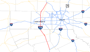
→Interstate 35W (abbreviated I-35W), an Interstate Highway, is the western half of Interstate 35 where it splits to serve different cities in Texas. I-35 splits into two branch routes, I-35W and I-35E at Hillsboro. I-35W runs north for 85.20 miles (137.12 km), carrying its own separate sequence of exit numbers. It runs through Fort Worth before rejoining with I-35E to reform I-35 in Denton. It is the more direct route for long-distance expressway traffic, as is noted on signs on I-35 leading into the I-35W/I-35E splits. This is one of two pairs of suffixed Interstates that has not been eliminated; I-35 also splits into I-35W and I-35E in Minneapolis-St. Paul, Minnesota.
Historically, other interstates were given directional suffixes. On every other interstate, the directional suffixes were phased out by giving the route a loop or spur designation. In the case of I-35, since both branches return to a unified interstate beyond the cities of Dallas and Fort Worth, the AASHTO committees allowed the suffixes to remain.
During the 1970s, billboards existed on I-35 encouraging travelers to take the faster and shorter I-35W route.
Contents
Exit list
County Location # Destinations Notes Hill I-35 south – WacoSouthbound exit and northbound entrance 3  FM 2959
7  FM 934
8  FM 66 – Itasca
12  FM 67 – Covington
Johnson Grandview 15  FM 916 – Grandview, Maypearl
16  SH 81 south / County Road 201 – Grandview
17  FM 2258
21 County Road 107, Barnesville Road – Greenfield Alvarado 24 

 I-35 Bus. north / FM 1706 / FM 3136 – Alvarado
26A US 67 – Cleburne, Dallas26B I-35 Bus. south – AlvaradoSouthbound exit and northbound entrance 27 County Road 604, County Road 707 Burleson 30  FM 917 – Joshua, Mansfield
32 Bethesda Road, Briaroaks Road 35 Briaroaks Road, Hidden Creek Parkway Southbound exit and northbound entrance 36 

 Spur 50 / FM 3391 (Renfro Street) to SH 174 south / Hidden Creek Parkway
Tarrant 37 SH 174 south (Wilshire Boulevard) – CleburneNo northbound exit Fort Worth 38 Alsbury Boulevard 39  FM 1187 (Rendon-Crowley Road) / McAllister Road
40 Garden Acres Drive 41 Risinger Road 42 Everman Parkway 43 Sycamore School Road Northbound exit is via exit 42 44 Altamesa Boulevard No southbound exit 45 I-20 – Abilene, DallasSigned as exits 45A (west) and 45B (east) 46A Felix Street Northbound exit is via exit 44 46B Seminary Drive 47 Ripy Street 48A Berry Street – TCU 48B Morningside Drive Southbound exit and northbound entrance 49A Allen Avenue Southbound exit is via exit 49B 49B 


US 287 Bus. (Rosedale Street)51 I-30 / US 287 south / US 377 south – Abilene, DallasSouth end of US 287/US 377 overlap; signed as exits 51A (west) and 51C (east) northbound 51B  SH 180 east (Lancaster Avenue) – Downtown Fort Worth
Southbound exit is via exit 51 52A  Spur 280 – Downtown Fort Worth
52B  US 377 north (Belknap Street) / SH 121 north (Airport Freeway) – DFW Airport
North end of US 377 overlap 52C  Spur 347 west (Belknap Street)
Southbound exit and entrance 52D Pharr Street 52E Carver Avenue Northbound exit and southbound entrance 53 Northside Drive, Yucca Avenue 54A  SH 183 (Northeast 28th Street)
Signed as exits 54A (east) and 54B (west) northbound 54B Papurt Street Southbound exit and northbound entrance 54C 33rd Street, Long Avenue Northbound exit and southbound entrance 56A Meacham Boulevard 56B Melody Hills Drive Northbound exit and southbound entrance 57 I-820 (Northeast Loop)Signed as exits 57A (east) and 57B (west) 58 Western Center Boulevard 59 Basswood Boulevard 60 US 81 north / US 287 north – DecaturNorth end of US 287 overlap 62 North Tarrant Parkway Northbound exit and southbound entrance 63 Heritage Trace Parkway 64 Golden Triangle Boulevard, Keller-Hicks Road 65  SH 170 east (Alliance Gateway Freeway)
66 Westport Parkway Denton 67 Alliance Boulevard 68 Eagle Parkway 70  SH 114 – Dallas, Bridgeport
72 Dale Earnhardt Way Northlake 74  FM 1171 – Flower Mound, Lewisville
Corral City 76  FM 407 – Argyle, Justin
Argyle 79 Crawford Road, Robson Ranch Road Denton 82  FM 2449 – Ponder
84  FM 1515 (Bonnie Brae Street)
Northbound exit and southbound entrance 85A I-35E south – DallasNorthbound exit and southbound entrance 85B West Oak Street Northbound exit and southbound entrance I-35 north – Oklahoma CityNorthbound exit and southbound entrance See also
References
- ^ Texas Department of Transportation. "Highway Designation File - Interstate Highway No. 35W". Retrieved 2010-10-1.
External links
Auxiliary and suffixed routes of Interstate 35 
Interstate Highways in Texas Signed Unsigned Categories:- Transportation in the Dallas – Fort Worth Metroplex
- Interstate Highway System
- Interstate Highways in Texas
- Interstate 35
- Freeways in the Dallas – Fort Worth Metroplex
- Transportation in Fort Worth, Texas
- Denton, Texas
- Transportation in Denton County, Texas
- Transportation in Hill County, Texas
- Transportation in Johnson County, Texas
- Transportation in Tarrant County, Texas


Wikimedia Foundation. 2010.