- Texas State Highway 121
Infobox TX State Highway
type=State
route=121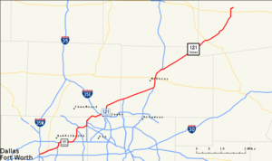
shields=
length_mi=85.56Texas Department of Transportation , [http://www.dot.state.tx.us/tpp/hwy/sh/sh0121.htm] ]
length_km=137.69
formed=by 1939
dir1=Southwest
dir2=Northeast
from=
junction=
|to=
previous_type=State
previous_route=120
next_type=State
next_route=122State Highway 121, locally known as 121, is a diagonal state highway, angling from southwest to northeast through north central
Texas . It runs from downtownFort Worth, Texas at the junction of Interstate 35W toBonham, Texas , just north of a junction with U.S. Highway 82.Route description
Sections between downtown Fort Worth and
Grapevine, Texas are freeway, including a small segment nearHurst, Texas that coincides with Interstate 820. AtBedford, Texas it has an interchange with State Highway 183, the Irving freeway that leads toward Dallas; it has an interchange with State Highway 360, which leads towardArlington, Texas , just to the west of the north entrance to theDallas/Fort Worth International Airport , to which State Highway 121 gives access. At Grapevine it has interchanges with State Highway 114 and Interstate 635 before the end of the freeway, where it becomes a surface road up to a split at Business 121 (which, as of 2008, is undergoing construction to convert to freeway standard) and a limited-access tollway that passes between Lewisville and Frisco.It is very heavily traveled south and west of McKinney and has become an urban highway due to the rapid growth of the Dallas-Fort Worth
Metroplex . Sections not yet of freeway quality are scheduled for upgrade or replacement as freeway; between Frisco and McKinney service roads are in place along with one overpass at Custer Road. Discussions have been held as to whether the upgraded freeway should be atoll road instead (see below), which has sparked controversy among area residents. North of McKinney the road is mainly a two-lane highway with some interchanges and is far less traveled than its southern segment.It meets Interstate 35E at
Lewisville, Texas , State Highway 289 nearFrisco, Texas , U.S. Highway 75 and U.S. Highway 380 in McKinney, Texas, U.S. Highway 69 atTrenton, Texas , and State Highway 78 just north of Bonham.Plans have been made to extend 121 south from Fort Worth to
Cleburne, Texas , as a toll road calledSouthwest Parkway to be operated by theNorth Texas Tollway Authority (NTTA).Toll road
State Highway 121 Toll or SH 121T is a toll facility to be built as the main lanes of State Highway 121 in Collin County, Texas. The North Texas Tollway Authority (NTTA), in conjunction with the Texas Department of Transportation (TxDOT), has studied potential options for constructing SH 121 as a tollway between the Dallas North Tollway and US 75 (Central Expressway), a distance of approximately 12 miles.
Currently, TxDOT has not allocated funding for the SH 121 main lanes between Preston Road (State Highway 289) and US 75, although construction of the Hillcrest Rd overpass has begun as of January 2007 and the Preston overpass is now open to traffic. Preliminary schematics for a toll financed facility were completed in 2001, but project funding options and right-of-way acquisition at the proposed toll plaza areas are still not determined. The project is estimated at costing $214 million. Frontage road construction began in 2003 and was completed in 2006. A date for completion of main lane construction has not yet been determined (only a small portion around Custer Road, which was built along with the frontage roads, is currently in place).
Plans are to use only electronic toll collection with no tollbooths or toll collectors along both the route like Westpark Tollway in Houston. People will be able to use a transponder unit known as a
TollTag attached to a vehicle's windshield, which communicates with overhead sensors to deduct tolls from the user's toll account. If a person does not have a TollTag, they can still drive on the tollway, because the overhead sensors will scan and record the licence plate number, locate the owner's address, and send a monthly bill showing their toll cost plus 1/3 of a toll cost (to cover the license plate processing) plus a $1.00 invoice fee. [http://www.texas121.org/pdf/tx121_map+rates.pdf]The original portion of the toll road from Business 121 near Coppell to
FM 2281 opened in May 2006, and toll collection started December 1 of that year. The tolled portion extended to Hillcrest Rd. in Plano on August 31, 2008.Controversy
In early 2007, the Spanish firm
Cintra agreed to a $2.8 billion, 50-year deal to finish building and maintain SH 121. [http://www.dallasnews.com/sharedcontent/dws/dn/latestnews/stories/022807dnmethighwaycontract.1187bfa.html] However, critics of the deal have questioned both its length--the contract allows Cintra to collect tolls for 50 years--and the fact that the North Texas Tollway Authority (NTTA) was prevented from bidding on the contract. In addition, general opposition to the toll plan organized, pointing out that the segment through Denton County had already been paid for. [http://www.stop121tolls.com/]To answer some of these complaints, Texas legislators pressed the
Texas Department of Transportation to allow the NTTA to bid. [http://www.texaskaos.com/showDiary.do?diaryId=3068] The Authority announced their proposed bid in early May 2007, which would provide approximately $3.3 billion in road funding, but is based on traffic counts that differ from those used by Cintra. [http://www.star-telegram.com/251/story/94756.html]On June 28, 2007, the Texas Transportation Commission announced it would pursue the proposal from the North Texas Tollway Authority (NTTA). [http://www.dot.state.tx.us/news/014-2007.htm]
Exit list
References
External links
* [http://www.texas121.org/ www.Texas121.org] - Official Site

Wikimedia Foundation. 2010.