- Interstate 35W (Minnesota)
-
Interstate 35W
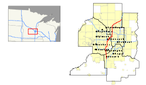
Interstate 35W highlighted in redRoute information Maintained by Mn/DOT Length: 41.778 mi[1] (67.235 km) Major junctions South end: 
 I-35 / I-35E in Burnsville
 I-494 in Bloomington , Richfield
 MN 62 in Richfield , Minneapolis
 I-94 in Minneapolis

 MN 36 / MN 280 in Roseville
 I-694 in New Brighton , Arden Hills
 US 10 in Mounds View
North end: I-35 / I-35E in Columbus,
near Forest LakeLocation Counties: Dakota, Hennepin, Ramsey, Anoka Highway system Main route of the Interstate Highway System
Main • Auxiliary • BusinessMinnesota Trunk Highways
Interstate • U.S. • State
Inter-County • County roads • Legislative routes← I-35EMN 36 →Interstate 35W (I-35W), is an Interstate Highway in the U.S. state of Minnesota, passing through downtown Minneapolis. It is one of two through routes for Interstate 35 through the Twin Cities of Minneapolis and Saint Paul, the other being Interstate 35E through downtown Saint Paul. I-35 splits into two branch routes: I-35W, which serves Minneapolis, and I-35E, which serves Saint Paul.
Traveling north, I-35 splits at Burnsville, and the I-35W route runs north for 41 miles, carrying its own separate sequence of exit numbers. It runs through the city of Minneapolis before rejoining with I-35E to re-form I-35 in Columbus near Forest Lake. I-35W supplanted sections of old U.S. Highway 8 northeast of Minneapolis and old U.S. Highway 65 south of Minneapolis that have since been removed from the U.S. highway system.
During the early years of the Interstate Highway System, branching Interstates with directional suffixes such as N, S, E, and W were common nationwide. On every other interstate nationwide, these directional suffixes have been phased out by re-designating the suffixed route numbers with a loop or spur route number designation. In the case of I-35 in the Twin Cities area, since neither branch is clearly the main route and both branches return to a unified interstate beyond the cities of Minneapolis and Saint Paul, the AASHTO officials have allowed the suffixes of E and W in Minnesota to remain in the present day. A similar split on I-35 continues to exist in Texas at Dallas-Fort Worth Metroplex, for similar reasons as the I-35 split in the Minneapolis - Saint Paul area. The Twin Cities and Dallas-Fort Worth Metroplex splits on I-35 are the only suffixed directional splits remaining in the Interstate Highway System in the present day.
Contents
Route description
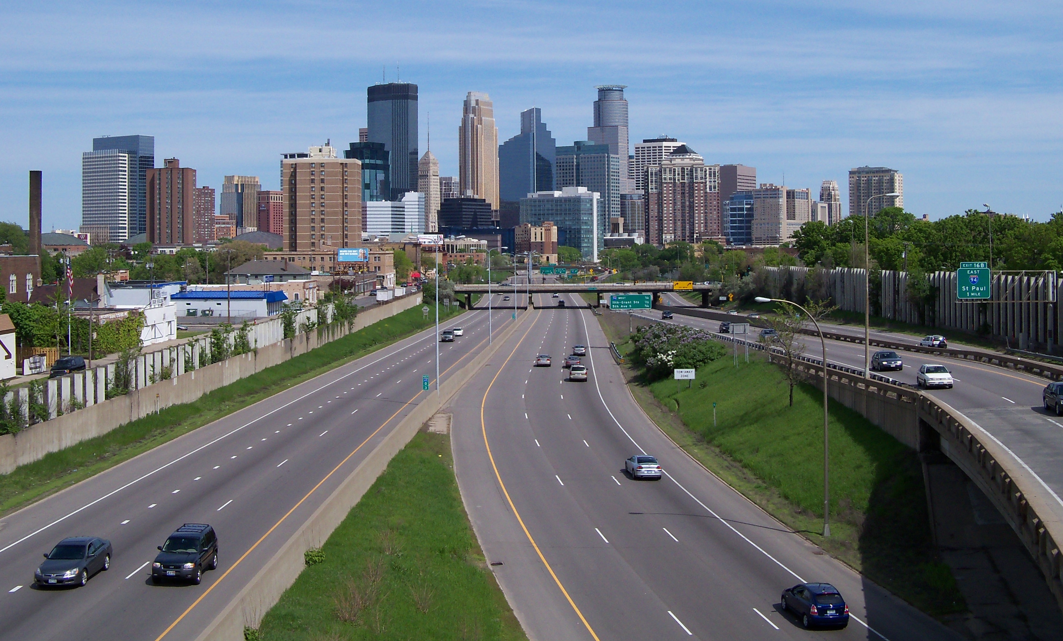
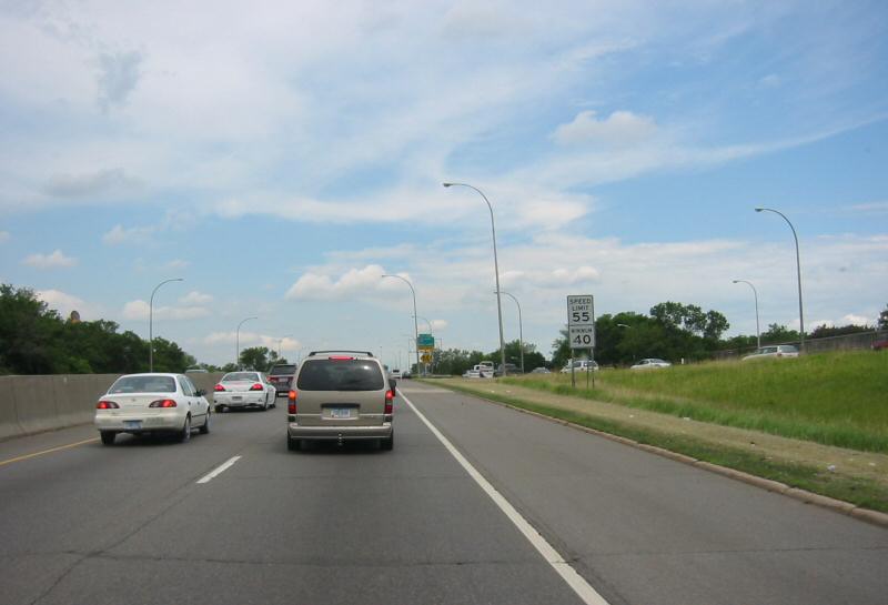
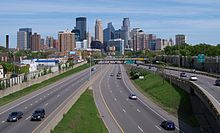 I-35W approaching downtown Minneapolis from the south.
The southern terminus of I-35W is at Burnsville, where I-35 splits into I-35E and I-35W. While I-35E takes a northeasterly path into Saint Paul, I-35W heads north into Minneapolis. I-35W maintains northbound in Burnsville with two lanes and adds a third lane at Burnsville Parkway. It then crosses the Minnesota River into Bloomington. At the Bloomington / Richfield city boundary line, I-35W has a cloverleaf interchange with Interstate 494. I-35W continues northbound into Richfield where it eliminates a lane, turns east and joins with State Highway 62 for about 1/4 mile in what is locally known as the Crosstown Commons. I-35W and Highway 62 split as two lanes of I-35W turn northbound toward downtown Minneapolis where I-35W adds back a third lane and then later a fourth and a fifth lane at the 46th Street on-ramp.
I-35W swerves slightly northeast immediately south of downtown to avoid the Washburn-Fair Oaks Mansion District. Three lanes then split north onto old Highway 65 which exits into downtown. The two right-hand lanes of I-35W curve a sharp right east where it runs side by side with Interstate 94 for less than a mile, allowing drivers to exchange highways. Here, the interchange with Interstate 94 does not have direct access for southbound I-35W to eastbound I-94 or westbound I-94 to northbound I-35W. Drivers must use Cedar Avenue and Washington Avenue exits to make these connections.
I-35W completes its eastern loop around downtown, crosses the Mississippi River on the new St. Anthony Falls bridge and winds northeast out of Northeast Minneapolis. Here I-35W passes through industrial areas near the suburbs of St. Anthony, Lauderdale, Roseville, and Arden Hills.
Interstate 35W meets Interstate 694 in New Brighton / Arden Hills at a cloverleaf interchange. U.S. Highway 10 joins I-35W one mile (1.6 km) north of the I-35W / I-694 interchange. I-35W and U.S. 10 run concurrently for another mile before U.S. 10 turns westward at Mounds View / Shoreview. I-35W passes next to the Twin Cities Ordnance Plant and again turns northeastward through the suburbs of Blaine and Lino Lakes. The communities of Lexington and Circle Pines are also nearby throughout this stretch. I-35W then merges with I-35E to re-form I-35 at Columbus near Forest Lake.
Interstate 35W carries its own set of exit numbers in the Twin Cities area, while Interstate 35E continues the Interstate 35 exit numbers between the Iowa state line and the city of Duluth.
Access between Interstate 35W and Interstate 35E in the Twin Cities area is done via circulator Interstate highways 494, 94, and 694; though many trunk and county highways, especially near the two downtown cores offer direct access between the two.
Legally, the route of Interstate 35W is defined as part of unmarked Legislative Route 394 in the Minnesota Statutes § 161.12(2),[2] Interstate 35W is not marked with this legislative number along the actual highway.
History
Flooding
Interstate 35W is prone to heavy-rain event flooding in several areas, intersecting both natural habitats including the Minnesota Valley National Wildlife Refuge between Burnsville and Bloomington; and the dense urban areas through the city of Minneapolis (see Twin Cities climate). In the great 1965 Minnesota River flood, the highway was under water in the flood plain wetlands south of the Minnesota River bridge at Burnsville.[3][4] Dikes have been constructed and the highway road has been raised since then.[5] The storm sewer system under I-35W in the urban core of south Minneapolis has also been cited as a place prone to flash floods during rain events. Improvements continue to be made to this area as part of future projects.[6][7]
Minnesota River crossing
Main article: I-35W Minnesota River bridgeWhen the Minnesota River bridge between Burnsville and Bloomington was completed in 1960 it was two-lanes in each direction. I-35W at the time only extended as far south as State Highway 13 in Burnsville. Improvements were made in 1984 to redeck and widen the bridge but subsoil problems found at the north end resulted in the new lanes being temporarily closed. In 1989, the lanes were opened as HOV when the Minnesota Department of Transportation expanded the north approach to carry the additional traffic.[8][8][9]
Mississippi River crossing
For more details on the bridge that collapsed in 2007, see I-35W Mississippi River bridge.For more details on the new 2008 replacement bridge, see I-35W Saint Anthony Falls Bridge.On Wednesday, August 1, 2007, the Interstate 35W Mississippi River Bridge in Minneapolis, collapsed into the Mississippi River around 6:05pm CDT. The metal arch bridge had a length of approximately 1,900 feet (580 m) and a roadway height of over 100 feet (30 m) above the river. The bridge connected Minneapolis southwest of the Mississippi River to the Southeast Minneapolis neighborhood and served residents in the northern suburbs of the metro area.[10][11][12] Due to the collapse of the I-35W Bridge, I-35W traffic was temporarily detoured through eastbound Interstate 94 to northbound State Highway 280 where it meets up with I-35W in Roseville.
The replacement Interstate 35W Saint Anthony Falls Bridge was built in less than a year and opened to traffic on September 18, 2008 at 5:00am CDT, three months ahead of schedule.[13][14][15]
I-35W and Highway 62 Crosstown Commons reconstruction project
 A pre-construction photo of the Crosstown Commons junction. The two left lanes are Interstate 35W northbound, while State Highway 62 enters via the ramp on the right.
The Crosstown Commons is one of the most congested traffic interchanges in Minnesota. While it is sometimes referred to as an intersection, it is a one-mile (1.6 km) merger or concurrency of Interstate 35W and State Highway 62. The layout is not a typical intersection: there is only a single level of roadbed and it creates a dogleg in Interstate 35W. This shared right-of-way "intersection" for Interstate 35W and State Highway 62 has been a topic of political debate for many years. There are only six lanes on the commons and all drivers merging from one highway to the other are required to change at least one lane as they merge and then diverge again. The name comes from the fact that Highway 62 is also known locally as the Crosstown Highway.
The project to improve the interchange began in May 2007, after bids were received in April 2007. The new interchange features three through-lanes for Interstate 35W in both directions, ending at 42nd Street, and two separate through-lanes for Highway 62 in each direction, eliminating the need to weave across traffic. The cost of correcting the deficiencies in that short stretch of highway was estimated to be $285 million.[16][17]
In 2004, the City of Minneapolis threatened to withhold municipal consent for the project unless new bus lanes and bus stations were included.[18] Lake Street currently has a bus station at grade with Interstate 35W on both sides. Eventually the project was altered to include the desired additional bus access. The bid was won by the Ames, Lunda, and Schafer consortium for the 2007 cost of $288 million. The project included 25 new bridges, 63 lane-miles of highway, and expanded the total roadway width from 6 lanes to 12 lanes at Lyndale Avenue. The bridges were cast in Coates, Minnesota and trucked in for on-site erection. The new design includes transit / HOV lanes and was completed in November 2010.[19]
Future
Access Project
The Interstate 35W Access Project proposes to add and reconfigure ramps roughly from Franklin Avenue to 45th Street in south Minneapolis. Some proposed changes include relocating the 35th / 36th Street ramps to 38th Street, adding new ramps at Lake Street, adding a northbound exit to 28th Street and reconstruct or widen roads to accommodate new ramps. For example, at Lake Street, there is only one off-ramp which comes from the south and an on-ramp going south. Federal funding was appropriated[20] but the project has been controversial.[21]
Interstate 35W Bus Rapid Transitway
The proposed I-35W Bus Rapid Transitway would run from the southern suburb of Lakeville to downtown Minneapolis on I-35W, passing through Burnsville, Bloomington, and Richfield.[22][23] Current plans call for a center high-occupancy toll lane or price-dynamic shoulder lane, for the exclusive use of buses, high-occupancy vehicles, and drivers willing to pay the dynamically priced toll, running from Lakeville to downtown Minneapolis.[24][25]
Exit list
County Location Mile[1] # Destinations Notes Dakota Burnsville 0.000 I-35 southSouthbound exit and northbound entrance 0.603 1  CR 42 (Crystal Lake Road)
Southbound exit and northbound entrance 2.328 2 Burnsville Parkway 2.693-2.707 3  MN 13 – Shakopee
Signed as exits 3A (north) and 3B (south) 3.166-3.196 4A Cliff Road (C.R. 5, C.R. 32) 4.153-4.427 4B Black Dog Road Hennepin Bloomington 5.225-5.251 5 106th Street 6.236 6  CR 1 (98th Street)
6.766 7A 94th Street 7.299 7B 90th Street 8.294 8 82nd Street 8.747-8.758 9  I-494 / MN 5
Signed as exits 9A (east) and 9B (west) Richfield 9.008 9C 76th Street Southbound exit and northbound entrance 10.248-10.276 10A  CR 53 (66th Street)
10.417-19.966 10B MN 62 west / 58th Street (MN 121 north)South end of MN 62 overlap 10.995-11.019 11A Lyndale Avenue Southbound exit and northbound entrance 11.532 11B MN 62 eastNorth end of MN 62 overlap Minneapolis 11.867-11.891 12A 60th Street Southbound exit and northbound entrance 12.518 12B Diamond Lake Road 13.632 13 46th Street (C.R. 46) 14.880-15.005 14 35th Street, 36th Street 15.484-15.627 15 31st Street, Lake Street (C.R. 3) Northbound exit and southbound entrance 16.194-16.892 16A I-94 west / Downtown exitsNorthbound exit and southbound entrance; old MN 65 17.4 16B I-94 east – St. PaulNorthbound exit and southbound entrance 17.652-17.697 17A  MN 55 east (Hiawatha Avenue)
Southbound exit and northbound entrance 17.378 17B I-94 west / 11th AvenueSouthbound exit and northbound entrance 17.968-18.134 17C 3rd Street (C.R. 122), Washington Avenue (C.R. 152) - University of Minnesota East Bank, West Bank 18.374-18.736 St. Anthony Falls Bridge over the Mississippi River 18.804-18.881 18  CR 36 (University Avenue) / 4th Street Southeast
19.564 19 East Hennepin Avenue (C.R. 52) Northbound exit and southbound entrance 20.535-20.779 21A 
 CR 27 (Stinson Boulevard) / CR 88 (New Brighton Boulevard)
19.641 21B Johnson Street Northbound exit and southbound entrance 21.518-21.552 22 To MN 280 / Industrial Boulevard, St. Anthony BoulevardRamsey Roseville 21.955-22.298 23A MN 280Southbound exit and northbound entrance 22.619-23.1 23B MN 36 / Cleveland Avenue (C.R. 46)23.513-23.547 24 County Road C (C.R. 23), Cleveland Avenue (C.R. 46) 24.578 25A County Road D (C.R. 19) New Brighton 24.920 25B  CR 88
CR 88Southbound exit and northbound entrance Arden Hills and New Brighton 26.090 26 County Road E2 (C.R. 46, C.R. 73) 26.760-26.776 27 I-694Signed as exits 27A (east) and 27B (west) 27.594 28A  CR 96
CR 96Arden Hills and Mounds View 28.250-28.481 28B US 10 east – St. PaulSouth end of U.S. 10 overlap; southbound exit and northbound entrance 28.250-25.481 28B  CR 10 west / County Road H (C.R. 9)
Northbound exit and southbound entrance 28.734 28C To CR 10 / County Road H (C.R. 9)No northbound exit 29.588-29.608 29 County Road I (C.R. 3) Shoreview and Mounds View 30.134 30 US 10 west – AnokaNorth end of U.S. 10 overlap Shoreview and Blaine 30.733 31A County Road J, 85th Avenue Northeast (C.R. 32) Northbound exit and southbound entrance Anoka Blaine 31.006 31B Lake Drive (C.R. 23) Northbound exit and southbound entrance 32.014 32  CR 52 (95th Avenue Northeast)
33.602 33  CR 17 (Lexington Avenue)
Lino Lakes 36.512 36  CR 23
CR 23Columbus 41.778 I-35 northNorthbound exit and southbound entrance References
- Cavanaugh, Patricia (October 2006). "Politics and Freeways: Building the Twin Cities Interstate System" (PDF). University of Minnesota. http://www.cura.umn.edu/publications/Freeways.pdf.
- ^ a b Minnesota Department of Transportation, Trunk Highway Log Point files, updated July 2006
- ^ ADDITIONAL ROUTES ADDED; FEDERAL AID. 161.12, Minnesota Statutes 2006, Minnesota Office of the Revisor of statutes, 2006
- ^ "The Bridges And Structures Of The Major Rivers Of Minneapolis And St. Paul". John Weeks. 2005. http://www.johnweeks.com/bridges/pages/mn04.html. Retrieved September 1, 2007.
- ^ John Gessner (January 7, 2000). "Burnsville looks back at a rich history". Thisweek Newspapers. http://www.thisweek-online.com/2000/january/7burns.html. Retrieved September 1, 2007.
- ^ "Flood Damage Reduction: What Minnesota Has Done and Still Needs To Do" (PDF). Minnesota Department of Natural Resources. December 2001. http://files.dnr.state.mn.us/natural_resources/climate/floods/fdr.pdf. Retrieved September 1, 2007.
- ^ 35W/Hwy 62 Reconstruction project F.A.Q. MN DoT
- ^ Capital Improvement Projects City of Minneapolis Public Works
- ^ a b Cassano, Dennis. (March 17, 1989) Star Tribune. Perpich orders study of closed I-35W bridge lanes. Section News, Page 8B.
- ^ Politics and Freeways: Building the Twin Cities Interstate System Patricia Cavanaugh University of Minnesota, p. 77, October 2006
- ^ "35W bridge collapses over Mississippi River, cars in the water". Pioneer Press. August 1, 2007. http://www.twincities.com/allheadlines/ci_6518669. Retrieved August 1, 2007.
- ^ "35W bridge over Mississippi collapsed". 5 EYEWITNESS NEWS. August 1, 2007. http://kstp.com/article/stories/S156329.shtml?cat=1. Retrieved August 1, 2007.
- ^ "35W Bridge Collapses". KARE11. August 1, 2007. http://www.kare11.com/news/news_article.aspx?storyid=261140. Retrieved August 1, 2007.[dead link]
- ^ "Engineer: Mn/DOT to open I-35W St. Anthony Falls Bridge to traffic at 5 a.m. Thursday, Sept. 18". MnDot. September 15, 2008. http://www.dot.state.mn.us/newsrels/08/09/15-I35wbridge.html.
- ^ Olson, Dan (December 17, 2007). "Above-ground construction work begins on 35W bridge". Minnesota Public Radio. http://minnesota.publicradio.org/display/web/2007/12/17/bridge_concrete/. Retrieved December 27, 2007.
- ^ "Drivers, Businesses Celebrate 35W Bridge Reopening". WCCO. September 18, 2008. http://wcco.com/bridgecollapse/replacement.bridge.opens.2.820209.html. Retrieved September 18, 2008.
- ^ "Mn/DOT invites contractors to bid on I-35W/Crosstown project". Minnesota Department of Transportation. http://www.dot.state.mn.us/metro/news/07/02/05crosstownbids.html. Retrieved May 31, 2007.
- ^ Rick Moore (December 15, 2006). "Freeways and politics: New Report Examines the Stories Behind The Twin Cities Interstate Freeway System". University of Minnesota. http://www1.umn.edu/umnnews/Feature_Stories/Freeways_and_politics.html.
- ^ Laurie Blake and Rochelle Olson. Star Tribune, August 24, 2004. http://www.stride-mn.org/newspaper/Strib-upgradedelayed.htm
- ^ Olson, Dan (May 15, 2007). "Untangling the infamous Crosstown Commons now underway". Minnesota Public Radio. http://minnesota.publicradio.org/display/web/2007/05/15/morecrosstown/. Retrieved May 31, 2007.
- ^ Earmark - Lake Street Access to I- 35W, Minneapolis
- ^ Road to Ruin. http://www.taxpayer.net/road2ruin/roads/i35waccessproject.htm[dead link]
- ^ URS Consulting (April 2004). "I-35W Bus Rapid Transit Study" (PDF). Minnesota Department of Transportation. Archived from the original on October 25, 2007. http://web.archive.org/web/20071025030615/http://projects.dot.state.mn.us/urs/035w/pdfs/Final+BRT+Report_print.pdf. Retrieved September 1, 2007.
- ^ Mn/DOT I-35W B.R.T. Study page
- ^ Minneapolis Urban Partnership Agreement
- ^ Minnesota Department of Transportation Urban Partnership Agreement
Auxiliary and suffixed routes of Interstate 35  Categories:
- Interstate Highway System
- Interstate Highways in Minnesota
- Interstate 35
- Transportation in Dakota County, Minnesota
- Transportation in Hennepin County, Minnesota
- Transportation in Ramsey County, Minnesota
- Transportation in Anoka County, Minnesota
- Transportation in Minneapolis, Minnesota


Wikimedia Foundation. 2010.