- U.S. Route 10 in Minnesota
-
This article is about the section of U.S. Route 10 in Minnesota. For the entire length of the highway, see U.S. Route 10.
U.S. Highway 10
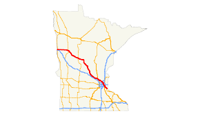
Highway 10 highlighted in red.Route information Maintained by MnDOT Length: 275.473 mi[2] (443.331 km) Existed: November 11, 1926[1] – present Major junctions West end:  US 10 at Fargo, ND
 US 75 at Moorhead
 US 59 at Detroit Lakes
 MN 210 at Staples , Motley

 MN 27 / MN 371 at Little Falls

 MN 15 / MN 23 at St Cloud

 US 169 / MN 101 at Elk River
 US 169 / MN 47 at Anoka
 MN 610 / MN 47 at Coon Rapids
 I-35W at Mounds View
 I-694 at Arden Hills
 I-35E at Little Canada
 I-94 / US 61 at St. Paul
East end: US 10 at Prescott, WILocation Counties: Clay, Becker, Otter Tail, Wadena, Todd, Morrison, Benton, Sherburne, Anoka, Ramsey, Washington Highway system United States Numbered Highways
List • Bannered • Divided • ReplacedMinnesota Trunk Highways
Interstate • U.S. • State
Inter-County • County roads • Legislative routes←  MN 9
MN 9MN 11  →
→U.S. Route 10 is a major divided highway for almost all of its length in the U.S. state of Minnesota. The route runs through the central portion of the state, following closely the alignment of the former Northern Pacific Railway (now BNSF) and connects the cities of Moorhead, Detroit Lakes, Wadena, Little Falls, St. Cloud, Anoka, Saint Paul, and Cottage Grove.
U.S. 10 within Minnesota is 270 miles (430 km) in length.
Contents
Route description
U.S. Highway 10 enters the state from North Dakota and heads through Moorhead parallel to Interstate 94 until it exits the city.
U.S. 10 then takes a more northerly route than Interstate 94 to St. Cloud, by heading through Detroit Lakes, Wadena, and Little Falls.
From St. Cloud to Mounds View, U.S. 10 is a busy route through the suburbs of St. Cloud and Minneapolis.
East of Mounds View, U.S. 10 is marked mostly along Interstate Highways until Saint Paul, where the route runs concurrent with U.S. 61 to Cottage Grove. Highway 10 then heads east to the Wisconsin state line and exits the state.
U.S. 10 is a divided highway along most of its length through the state, with posted 65 mph speed limits along much of the way, except for two-lane or undivided four-lane stretches through Wadena and Motley. There are some 60 mph (97 km/h) posted speed limits in the four-lane section between Elk River and Anoka.
Legally, the Minnesota section of U.S. 10 is defined as unmarked Constitutional / Legislative Routes 2, 37, 27, 3, 62, and 94 in the Minnesota Statutes §§ 161.114(2) and 161.115(25).[3][4] U.S. 10 is not marked with these legislative numbers along the actual highway.
History
U.S. Highway 10 was established on November 11, 1926.[1] Originally, the route split between Moorhead and St. Cloud into U.S. 10N and U.S. 10S. In 1934, Highway 10S was replaced by U.S. Highway 52, and 10N became simply Highway 10.[5]
U.S. 10 in Minnesota was paved between St. Cloud and the Twin Cities as early as 1929. The remainder of the route was paved by 1950.[5]
The four-lane divided highway section between the cities of Elk River and Anoka was constructed by 1942.[5]
The freeway section of Highway 10 between the city of Anoka and University Avenue (at the Coon Rapids / Blaine boundary line) was completed in the early 1970s. The new freeway section of Highway 10 between University Avenue and Interstate 35W in Mounds View was completed in 1999.[5]
From 1934 to 1999, U.S. 10 was located on a different alignment between Coon Rapids, Spring Lake Park, and Mounds View. This is now known as County Road 10.
When Interstate 694 and Interstate 35E were completed in the late 1960s, U.S. 10 was then signed concurrently with these routes east of Mounds View to the city of St. Paul.[5]
Major intersections
County Location Mile[2][6][7] Destinations Notes Red River of the North 0.000 US 10Clay Moorhead 0.428 US 75West end of US 75 concurrency 1.450 US 75East end of US 75 concurrency Glyndon Township 5.954  MN 336
Riverton Township 12.786 MN 9Eglon Township 24.438  MN 32
MN 32Becker Detroit Lakes 44.337-44.357  US 59 / MN 34
Burlington Township 54.517  MN 87
MN 87Otter Tail Gorman Township 59.826  MN 228
Perham Township 66.511  MN 78
MN 78Newton Township 80.261  MN 106
Wadena Wadena 89.992  US 71
US 71Todd Staples 107.656-107.663 MN 210West end of MN 210 concurrency Morrison Motley 114.798 MN 210East end of MN 210 concurrency Randall 135.668  MN 115
Green Prairie Township 143.277-143.467 Mississippi River Little Falls 144.710-144.731 MN 371145.917 MN 27Benton Sartell 173.083-173.289 MN 15St. Cloud 178.015 MN 23Sherburne St. Cloud 180.158  MN 301
Clear Lake 188.794  MN 24
MN 24Becker 194.209  MN 25
MN 25West end of MN 25 concurrency Big Lake 203.712 MN 25East end of MN 25 concurrency Elk River 214.325 US 169 north, MN 101 southWest end of US 169 concurrency Anoka Anoka 224.807 US 169 south
MN 47 northEast end of US 169 concurrency
West end of MN 47 concurrencyCoon Rapids 232.415 MN 47East end of MN 47 concurrency Blaine 233.088-233.268 MN 610234.352  MN 65
MN 65Ramsey Mounds View 237.035 I-35WNorth end of I-35W concurrency Arden Hills 238.393 I-35W,  CR 10 (old US 10)
South end of I-35W concurrency 240.433 I-694West end of I-694 concurrency Little Canada 275.460 I-694 / I-35EEast end of I-694 concurrency
North end of I-35E concurrencySt. Paul 281.377 I-35E / I-94South end of I-35E concurrency
West end of I-94 concurrency283.321 I-94 / US 61East end of I-94 concurrency
North end of US 61 concurrencyWashington Denmark Township 299.761 US 61South end of US 61 concurrency St. Croix River 302.802 Point Douglas Drawbridge 1.000 mi = 1.609 km; 1.000 km = 0.621 mi
Concurrency terminus • Closed/Former • Incomplete access • UnopenedReferences
- ^ a b Weingroff, Richard F. (January 9, 2009). "From Names to Numbers: The Origins of the U.S. Numbered Highway System". Federal Highway Administration. http://wwwcf.fhwa.dot.gov/infrastructure/numbers.cfm. Retrieved September 25, 2010.
- ^ a b "Trunk Highway Log Point Listing - Construction District 5" (PDF). Minnesota Department of Transportation. August 20, 2010. http://www.dot.state.mn.us/roadway/data/reports/logpoint/metrolpt.pdf. Retrieved September 25, 2010.
- ^ 161.114, Minnesota Statutes 2006
- ^ 161.115, Minnesota Statutes 2006
- ^ a b c d e Riner, Steve. "Details of routes 1-25". The Unofficial Minnesota Highways Page. http://www.steve-riner.com/mnhighways/r1-25.htm#10. Retrieved September 25, 2010.[unreliable source]
- ^ "Trunk Highway Log Point Listing - Construction District 4" (PDF). Minnesota Department of Transportation. August 23, 2010. http://www.dot.state.mn.us/roadway/data/reports/logpoint/d4.pdf. Retrieved September 25, 2010.
- ^ "Trunk Highway Log Point Listing - Construction District 1" (PDF). Minnesota Department of Transportation. August 23, 2010. http://www.dot.state.mn.us/roadway/data/reports/logpoint/d3.pdf. Retrieved September 25, 2010.
U.S. Route 10Previous state:
North DakotaMinnesota Next state:
WisconsinCategories:- U.S. Highways in Minnesota
- U.S. Route 10
- Expressways in the United States


Wikimedia Foundation. 2010.