- Clay County, Minnesota
-
Clay County, Minnesota 
Location in the state of Minnesota
Minnesota's location in the U.S.Founded March 8, 1862 [1] Named for Henry Clay Seat Moorhead Largest city Moorhead Area
- Total
- Land
- Water
1,052.74 sq mi (2,727 km²)
1,045.24 sq mi (2,707 km²)
7.49 sq mi (19 km²), 0.71%Population
- (2010)
- Density
58,999
49/sq mi (19/km²)Time zone Central: UTC-6/-5 Website www.co.clay.mn.us Clay County is a county located in the U.S. state of Minnesota. As of 2010, the population was 58,999.[1] Its name is in honor of American statesman Henry Clay, member of the United States Senate from Kentucky and United States Secretary of State in the 19th century. Its county seat is Moorhead.[2] It was originally called Breckenridge County, but changed to its current name in 1862.
Clay County is part of the Fargo, ND–MN Metropolitan Statistical Area.
Contents
Geography
According to the 2000 census, the county has a total area of 1,052.74 square miles (2,726.6 km2), of which 1,045.24 square miles (2,707.2 km2) (or 99.29%) is land and 7.49 square miles (19.4 km2) (or 0.71%) is water.[3]
Major highways
 Interstate 94
 U.S. Highway 10
 U.S. Highway 52
 U.S. Highway 75
Adjacent counties
- Norman County, Minnesota (north)
- Becker County, Minnesota (east)
- Otter Tail County, Minnesota (southeast)
- Wilkin County, Minnesota (south)
- Richland County, North Dakota (southwest)
- Cass County, North Dakota (west)
Law and government
Clay County is governed by a board of five commissioners.
- Wayne Ingersol (Moorhead) 1st District
- Jerry Waller (Dilworth) 2nd District
- Jon Evert (Comstock) 3rd District (chair)
- Kevin Campbell (Moorhead) 4th District
- Mike McCarthy (Moorhead) 5th District
Demographics
Historical populations Census Pop. %± 1860 72 — 1870 92 27.8% 1880 5,887 6,298.9% 1890 11,517 95.6% 1900 17,942 55.8% 1910 19,640 9.5% 1920 21,780 10.9% 1930 23,120 6.2% 1940 25,337 9.6% 1950 30,363 19.8% 1960 39,080 28.7% 1970 46,585 19.2% 1980 49,327 5.9% 1990 50,422 2.2% 2000 51,229 1.6% 2010 58,999 15.2% U.S. Decennial Census As of the census[4] of 2000, there were 51,229 people, 18,670 households, and 12,340 families residing in the county. The population density was 49 people per square mile (19/km²). There were 19,746 housing units at an average density of 19 per square mile (7/km²). The racial makeup of the county was 93.99% White, 0.52% Black or African American, 1.44% Native American, 0.88% Asian, 0.03% Pacific Islander, 1.67% from other races, and 1.47% from two or more races. 3.65% of the population were Hispanic or Latino of any race. 40.4% were of Norwegian and 26.8% German ancestry according to Census 2000.
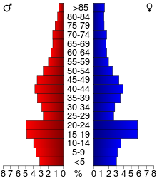 Age pyramid of county residents based on 2000 U.S. census data.
There were 18,670 households out of which 33.80% had children under the age of 18 living with them, 53.90% were married couples living together, 8.80% had a female householder with no husband present, and 33.90% were non-families. 26.10% of all households were made up of individuals and 10.60% had someone living alone who was 65 years of age or older. The average household size was 2.53 and the average family size was 3.07.
In the county the population was spread out with 25.00% under the age of 18, 17.10% from 18 to 24, 25.70% from 25 to 44, 19.30% from 45 to 64, and 12.90% who were 65 years of age or older. The median age was 32 years. For every 100 females there were 93.70 males. For every 100 females age 18 and over, there were 89.10 males.
The median income for a household in the county was $37,889, and the median income for a family was $49,192. Males had a median income of $34,176 versus $23,149 for females. The per capita income for the county was $17,557. About 7.40% of families and 13.20% of the population were below the poverty line, including 13.30% of those under age 18 and 7.50% of those age 65 or over.
Presidential Election Results 2000-2008 Year Democrat Republican 2008 76.48% 1,582,973 23.05% 477,038 2004 70.25% 1,439,724 29.15% 597,405 2000 68.63% 1,280,547 28.65% 534,542 Cities and towns
Cities Townships CDP Other communities Climate and weather
Moorhead, Minnesota Climate chart (explanation) J F M A M J J A S O N D 0.71800.62461.336191.456332.869453.977552.882602.681572.671472.25635137200.8226Average max. and min. temperatures in °F Precipitation totals in inches Source: The Weather Channel[5] Metric conversion J F M A M J J A S O N D 18-8-1816-4-14332-735131712179925137128166527146522855132253-721-6-14Average max. and min. temperatures in °C Precipitation totals in mm In recent years, average temperatures in the county seat of Moorhead have ranged from a low of 0 °F (−18 °C) in January to a high of 82 °F (28 °C) in July, although a record low of −48 °F (−44 °C) was recorded in January 1887 and a record high of 114 °F (46 °C) was recorded in July 1936. Average monthly precipitation ranged from 0.64 inches (16 mm) in February to 3.90 inches (99 mm) in June.[5]
See also
References
- ^ "2010 Census Redistricting Data (Public Law 94-171) Summary File". American FactFinder. United States Census Bureau. http://factfinder2.census.gov/faces/tableservices/jsf/pages/productview.xhtml?pid=DEC_10_PL_GCTPL2.ST05&prodType=table. Retrieved 25 April 2011.
- ^ "Find a County". National Association of Counties. http://www.naco.org/Counties/Pages/FindACounty.aspx. Retrieved 2011-06-07.
- ^ "Census 2000 U.S. Gazetteer Files: Counties". United States Census. http://www.census.gov/tiger/tms/gazetteer/county2k.txt. Retrieved 2011-02-13.
- ^ "American FactFinder". United States Census Bureau. http://factfinder.census.gov. Retrieved 2008-01-31.
- ^ a b "Monthly Averages for Moorhead, Minnesota". The Weather Channel. http://www.weather.com/weather/wxclimatology/monthly/graph/USMN0514. Retrieved 2011-11-06.
External links

Norman County Cass County, North Dakota 
Becker County  Clay County, Minnesota

Richland County, North Dakota Wilkin County Otter Tail County Municipalities and communities of Clay County, Minnesota Cities 
Townships Alliance | Barnesville | Cromwell | Eglon | Elkton | Elmwood | Felton | Flowing | Georgetown | Glyndon | Goose Prairie | Hagen | Hawley | Highland Grove | Holy Cross | Humboldt | Keene | Kragnes | Kurtz | Moland | Moorhead | Morken | Oakport | Parke | Riverton | Skree | Spring Prairie | Tansem | Ulen | Viding
CDP Unincorporated
communitiesGhost towns Fargo-Moorhead Metropolitan Area (ND-MN) Counties Cass | Clay

Main cities Surrounding
areasAlice | Amenia | Argusville | Arthur | Ayr | Barnesville | Briarwood | Buffalo | Casselton | Comstock | Davenport | Enderlin | Erie | Felton | Frontier | Gardner | Georgetown | Grandin | Glyndon | Harwood | Hawley | Hitterdal | Horace | Hunter | Kindred | Leonard | Mapleton | North River | Oxbow | Page | Prairie Rose | Sabin | Tower City | Reile's Acres | Ulen | Wheatland† - county seatCategories:- Minnesota counties
- Clay County, Minnesota
- Fargo–Moorhead


Wikimedia Foundation. 2010.