- Northfield, Minnesota
-
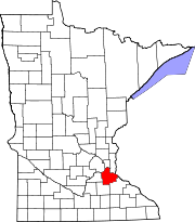
Northfield, Minnesota — City — Location of Northfield, Minnesota Coordinates: 44°27′30″N 93°9′40″W / 44.45833°N 93.16111°WCoordinates: 44°27′30″N 93°9′40″W / 44.45833°N 93.16111°W Country United States State Minnesota Counties Rice, Dakota Founded 1855 Incorporated 1868 Government - Mayor Mary Rossing Area - Total 7.0 sq mi (18.2 km2) - Land 7.0 sq mi (18.1 km2) - Water 0.04 sq mi (0.1 km2) 0.43% Elevation 912 ft (278 m) Population (2010)[1] - Total 20,007 - Density 2,858.1/sq mi (1,099.3/km2) Time zone Central (UTC-6) - Summer (DST) Central (UTC-5) ZIP code 55057 Area code(s) 507 FIPS code 27-46924[2] GNIS feature ID 0648725[3] Website www.ci.northfield.mn.us Northfield is a city in Dakota and Rice counties in the U.S. state of Minnesota. Most of the city lies in Rice County, and only a small part of the city extends into Dakota County. The population was 20,007 at the 2010 census.[1]
Contents
History
This European-American town was founded by John W. North[4] in 1855. Northfield was an early agricultural center with many wheat and corn farms. The town also supported lumber and flour mills powered by the Cannon River. As the "wheat frontier" moved west, dairy operations and diversified farms replaced the wheat-based agriculture. The region has since moved away from dairy and beef operations. Today it produces substantial crops of corn, and soybeans, as well as producing hogs. The local cereal producer Malt-O-Meal is one of the few remnants of Northfield's historic wheat boom. They produce the most wonderful cereal and often fill the town with scents of puffed wheat or cocoa dyno-bites. The city's motto, "Cows, Colleges, and Contentment", reflects the influence of the dairy farms.
Since early in its history, Northfield has been a center of higher education. Carleton College (then Northfield College) was founded in 1866 on the northern edge of town by the Minnesota Conference of Congregational Churches. St. Olaf College was founded in 1874 on the western edge of town by Norwegian Lutheran immigrant pastors and farmers, who were eager to preserve their faith and culture by training teachers and preachers. These two institutions, which today enroll a total of more than 5,000 students, make Northfield a college town.
In the 1970s, completion of Interstate Highway 35 (six miles west of Northfield) enabled the expansion of the Minneapolis-St. Paul metro area south of the Minnesota River. Northfield is now growing and urbanizing.[citation needed] The downtown grain elevator accepted its last load of corn in 2000 and was torn down in 2002. Residential growth has been rapid since the mid-1990s. Northfield is becoming a suburb and bedroom community on the southern fringe of the Twin Cities metropolitan area.[citation needed] A new area hospital, which opened in 2003 in the northwest corner of town, is in Dakota County.
Many of the buildings in downtown Northfield are reasonably well-preserved examples of late 19th & early 20th century architecture. Because of early economic successes and the stability of two thriving colleges, the downtown is more extensive and better maintained than in similar Midwest communities.[citation needed] Today, commercial development continues on the southern edge of the city, where room for growth remains.
Geography
According to the United States Census Bureau, the city has a total area of 7.0 square miles (18.2 km²), of which, 7.0 square miles (18.1 km²) of it is land and 0.04 square miles (0.1 km²) of it (0.43%) is water.
Roughly speaking, the town is centered around the Cannon River and rises both to the east and the west away from this bisecting river body.
Interstate 35 is six miles (10 km) west of Northfield. Minnesota State Highways 3, 19, and 246 are three of the main routes in the city.
Demographics
Historical populations Census Pop. %± 1880 2,296 — 1890 2,659 15.8% 1900 3,210 20.7% 1910 3,265 1.7% 1920 4,023 23.2% 1930 4,153 3.2% 1940 4,533 9.2% 1950 7,487 65.2% 1960 8,707 16.3% 1970 10,235 17.5% 1980 12,562 22.7% 1990 14,684 16.9% 2000 17,147 16.8% 2010 20,007 16.7% U.S. Decennial Census As of the census[2] of 2000, there were 17,147 people, 4,909 households, and 3,210 families residing in the city. The population density was 2,452.2 people per square mile (947.1/km²). There were 5,119 housing units at an average density of 732.1 per square mile (282.8/km²). The racial makeup of the city was 92.57% White, 0.90% African American, 0.34% Native American, 2.36% Asian, 0.05% Pacific Islander, 1.78% from other races, and 1.99% from two or more races. Hispanic or Latino of any race were 5.73% of the population.
There were 4,909 households out of which 35.4% had children under the age of 18 living with them, 52.7% were married couples living together, 9.6% had a female householder with no husband present, and 34.6% were non-families. 27.5% of all households were made up of individuals and 9.6% had someone living alone who was 65 years of age or older. The average household size was 2.53 and the average family size was 3.08.
In the city the population was spread out with 20.2% under the age of 18, 32.1% from 18 to 24 (a figure heavily influenced by the student population of St. Olaf and Carleton College), 21.0% from 25 to 44, 16.1% from 45 to 64, and 10.5% who were 65 years of age or older. The median age was 23 years. For every 100 females there were 91.3 males. For every 100 females age 18 and over, there were 87.7 males.
The median income for a household in the city was $49,972, and the median income for a family was $61,055. Males had a median income of $40,008 versus $28,456 for females. The per capita income for the city was $18,619. About 2.8% of families and 7.2% of the population were below the poverty line, including 5.3% of those under age 18 and 7.4% of those age 65 or over.
Economy
Early in the city's history, local merchants created a small town square between Fourth Street to the north, Division Street to the east, the Cannon River to the west, and the southern storefronts. The old Ames Mill/Malt-O-Meal plant was also nearby, originally powered by the dam on the river. Bridge Square and the surrounding downtown area remain a strong cultural attraction for the city. The square has several amenities including a large fountain, a memorial statue, and a concession stand known as "the popcorn wagon" run by the senior center. Several scenic walkways follow the river, and numerous shops and boutiques can be found on the neighboring streets.
Businesses serving the growing senior citizen community of Northfield have expanded to include the Village on the Cannon, Millstream Commons, and new construction at the Northfield Retirement Center complex. The northern edge of the city has also been expanding with several residential and commercial developments.
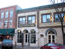
Jesse James' and the James-Younger Gang's 1876 attempt to rob the First National Bank of Northfield serves as a heritage tourism draw for the town. The original bank building was converted to a museum operated by the Northfield Historical Society. The First National Bank of Northfield operates from a main office built half a block away from the historic site. In its front lobby, a glass case showcases a gun used during the robbery.
The Northfield Convention and Visitors Bureau provides comprehensive tourism information and visit planning services.
Arts and culture
Defeat of Jesse James Days
On September 7, 1876, Northfield experienced one of its most important historical events: an outlaw gang led by Jesse James tried to rob the First National Bank of Northfield. Local citizens, recognizing what was happening, armed themselves and resisted the robbers and successfully thwarted the theft. The gang killed the bank's cashier, Joseph Lee Heywood and a Swedish immigrant, Nicholas Gustafson. A couple of members of the James-Younger Gang were killed in the street, while the rest were cornered near Madelia, Minnesota. Jesse and Frank James escaped west into the Dakotas, while the remaining gang members were killed or taken into custody. Considering the James gang as related to postwar insurgency, the raid has sometimes been called the last major event of the American Civil War. One of Northfield's slogans is "Jesse James Slipped Here", based on the raid's failure (this is not a real motto, as a resident I have never heard of it).
The events have become the basis of an annual outdoor heritage festival called The Defeat of Jesse James Days.[5] It is held the weekend after Labor Day and is among the largest outdoor celebrations in Minnesota. Thousands of visitors witness reenactments of the robbery, and related activities such as a championship rodeo, carnival, and parade, horseshoe hunt, as well as discovering arts and crafts expositions, and attending musical performances. The local bakery, Quality Bakery, makes feet-shaped donuts in honor of the "de-feet of jesse james".
For over a decade friends and family have come to love the annual "Horseshoe Hunt" the week prior to the celebration where an antique horseshoe is hidden somewhere within the city on public grounds. This has become a tradition and family event for locals. The finder claims that years cash purse.
In popular media
- Films based on the failed raid include The Great Northfield Minnesota Raid (1972) and The Long Riders(1980).
Park and recreation
The city owns 35 parks consisting of over 400 acres (1.6 km2) of land.[6] Three of these parks have picnic shelters.[6]
The Carleton College Cowling Arboretum is a sizable, well-established arboretum and nature preserve adjacent to Carleton College. It offers extensive trails for walking in the summer and cross-country skiing in the winter.
Government and politics
The City of Northfield operates as a Mayor-Council form of government. The City Administrator is responsible for managing daily operations. The current mayor is Mary Rossing.[7]
Northfield is served by Minnesota State Senator Al DeKruif (GOP) in District 25 and State Representative Kelby Woodard (GOP) in District 25B.
Education
Northfield is home to St. Olaf and Carleton colleges. Their student and staff populations account for a large portion of the town's year-round population.
The Northfield public school district operates three elementary schools, a middle school, and a high school. Northfield High School is known as one of the high schools with the highest standards in southern Minnesota.[citation needed] In addition, Northfield has public charter schools: ARTech (grades 6–12) and Prairie Creek Community School (grades K–5) in nearby Castle Rock. They receive state funding from the State of Minnesota.
Notable natives and residents
- Peter Agre, Nobel laureate in chemistry
- Cyril Archibald, member of Canadian Parliament
- Ian Barbour, Winifred & Atherton Bean Professor of Science, Technology & Society, Emeritus at Carleton College, winner of 1999 Templeton Prize
- Steven Brust, fantasy author and musician
- Paulette Carlson, country music singer
- F. Melius Christiansen, pioneer of a capella choral music
- Laurence McKinley Gould, 20th-century American geologist, educator, polar explorer.
- Joel Heatwole, member of U.S. House of Representatives
- Lucius Roy Holbrook, U.S. Army major general
- Alexandra Holden, television and film actress
- Siri Hustvedt, novelist, poet, and essayist
- Karl Rolvaag, governor of Minnesota
- Ole Edvart Rølvaag, novelist
- Gilmore Schjeldahl, inventor and entrepreneur, builder of "Echo" satellites, plastic bag machines
- Peter Schjeldahl, art critic and writer
- Marilyn Sellars, country music singer
- Chad Setterstrom, professional football player
- Mark Setterstrom, professional football player
- Edward John Thye, governor of Minnesota, and U.S. Senator
- Paul Wellstone, U.S. Senator
- Jon Wee, professional juggler
- Johnny Western, singer-songwriter, actor, radio host
- Charles Augustus Wheaton, major figure in the abolitionist movement and Underground Railroad
- Joan N. Ericksen, a Federal judge in the Minnesota district
- Jerome J. Workman, Jr., American spectroscopist, editor, author
- Michael Dorris, author, lived in Northfield with their family for a short period of time
- Svea Drentlaw, composer, mathematician, trend-setter, sister of noted actress and artist Johanna Drentlaw
References
- ^ a b "2010 Census Redistricting Data (Public Law 94-171) Summary File". American FactFinder. United States Census Bureau. http://factfinder2.census.gov/faces/tableservices/jsf/pages/productview.xhtml?pid=DEC_10_PL_GCTPL2.ST13&prodType=table. Retrieved 27 April 2011.
- ^ a b "American FactFinder". United States Census Bureau. http://factfinder.census.gov. Retrieved 2008-01-31.
- ^ "US Board on Geographic Names". United States Geological Survey. 2007-10-25. http://geonames.usgs.gov. Retrieved 2008-01-31.
- ^ Fedo, Michael (2002). Pocket Guide to Minnesota Place Names. Canada: Minnesota Historical Society Press. pp. 109. ISBN 0-87351-424-6. http://shop.mnhs.org/moreinfomhspress.cfm?Product_ID=139.
- ^ "The Defeat of Jesse James Days Celebration". DJJD Committee, Inc.. 2006. http://djjd.org. Retrieved 2007-09-09.
- ^ a b "Parks". Streets, Parks and Facilities Division. City of Northfield. 2008. http://www.ci.northfield.mn.us/parksandrec/parks. Retrieved 2008-07-08.
- ^ "City Council". City of Northfield. http://www.ci.northfield.mn.us/government/citycouncil. Retrieved 2009-01-24.
External links
- City of Northfield, MN -- Official site
- Northfield.org
- Northfield Convention and Visitors Bureau -- Visitor Information
- Northfield, Minnesota at the Open Directory Project
Municipalities and communities of Dakota County, Minnesota County seat: Hastings Cities Apple Valley | Burnsville | Coates | Eagan | Farmington | Hampton | Hastings‡ | Inver Grove Heights | Lakeville | Lilydale | Mendota | Mendota Heights | Miesville | New Trier | Northfield‡ | Randolph | Rosemount | South St. Paul | Sunfish Lake | Vermillion | West St. Paul
Townships Unincorporated
communitiesCastle Rock | Eureka Center | Waterford
Ghost town Footnotes ‡This populated place also has portions in an adjacent county or counties
Municipalities and communities of Rice County, Minnesota County seat: Faribault Cities Townships Bridgewater | Cannon City | Erin | Forest | Morristown | Northfield | Richland | Shieldsville | Walcott | Warsaw | Webster | Wells | Wheatland | Wheeling
Unincorporated
communitiesCannon City | Little Chicago | Moland‡ | Ruskin | Warsaw
Footnotes ‡This populated place also has portions in an adjacent county or counties
Categories:- Cities in Minnesota
- Populated places in Dakota County, Minnesota
- Populated places in Rice County, Minnesota
- University towns in the United States
- James-Younger Gang
Wikimedia Foundation. 2010.


