- Mahnomen County, Minnesota
-
Mahnomen County, Minnesota 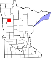
Location in the state of Minnesota
Minnesota's location in the U.S.Founded December 27, 1906 [1] Named for Ojibway word for wild rice, whose root word is "mano," or spirit. Seat Mahnomen Largest city Mahnomen Area
- Total
- Land
- Water
582.99 sq mi (1,510 km²)
556.14 sq mi (1,440 km²)
26.85 sq mi (70 km²), 4.61%Population
- (2010)
- Density
5,413
9/sq mi (4/km²)Time zone Central: UTC-6/-5 Mahnomen County (pronunciation: /məˈnoʊmən/ mə-noh-mən) is a county located in the U.S. state of Minnesota. As of 2010, the population was 5,413.[1] Its county seat is Mahnomen[2]. The entire county is part of the White Earth Indian Reservation [2]. It is the only county in Minnesota entirely within an Indian reservation. The county, along with East Polk and Becker County, are one of the biggest cattle-raising areas in the northwestern part of Minnesota.
Contents
Geography
According to the 2000 census, the county has a total area of 582.99 square miles (1,509.9 km2), of which 556.14 square miles (1,440.4 km2) (or 95.39%) is land and 26.85 square miles (69.5 km2) (or 4.61%) is water.[3]
Major highways
 U.S. Highway 59
 Minnesota State Highway 113
 Minnesota State Highway 200
Adjacent counties
- Polk County (north)
- Clearwater County (east)
- Becker County (south)
- Norman County (west)
Demographics
Historical populations Census Pop. %± 1910 3,249 — 1920 6,197 90.7% 1930 6,153 −0.7% 1940 8,054 30.9% 1950 7,059 −12.4% 1960 6,341 −10.2% 1970 5,638 −11.1% 1980 5,535 −1.8% 1990 5,044 −8.9% 2000 5,190 2.9% 2010 5,413 4.3% U.S. Decennial Census As of the census[4] of 2000, there were 5,190 people, 1,969 households, and 1,366 families residing in the county. The population density was 9 people per square mile (4/km²). There were 2,700 housing units at an average density of 5 per square mile (2/km²). The racial makeup of the county was 62.85% White (3262 people) 0.13% Black or African American (7 people), 28.55% Native American (1482 people), 0.06% Asian (3 people), 0.31% from other races (16 people), and 8.09% (420 people) from two or more races. 0.89% of the population (46 people) were Hispanic or Latino of any race. 29.4% (1525 people) were of German and 17.0% (882 people) Norwegian ancestry according to Census 2000.
There were 1,969 households out of which 32.40% had children under the age of 18 living with them, 51.60% were married couples living together, 11.60% had a female householder with no husband present, and 30.60% were non-families. 27.00% of all households were made up of individuals and 14.90% had someone living alone who was 65 years of age or older. The average household size was 2.60 and the average family size was 3.14.
In the county the population was spread out with 29.20% under the age of 18, 7.20% from 18 to 24, 23.50% from 25 to 44, 23.40% from 45 to 64, and 16.70% who were 65 years of age or older. The median age was 38 years. For every 100 females there were 102.90 males. For every 100 females age 18 and over, there were 98.40 males.
The median income for a household in the county was $30,053, and the median income for a family was $35,500. Males had a median income of $23,614 versus $21,000 for females. The per capita income for the county was $13,438. About 11.80% of families and 16.70% of the population were below the poverty line, including 21.30% of those under age 18 and 15.30% of those age 65 or over.
 Age pyramid of county residents based on 2000 U.S. census data.
Cities and towns
Cities Townships CDP See also
- National Register of Historic Places listings in Mahnomen County, Minnesota
- USS Mahnomen County (LST-912)
References
- ^ "2010 Census Redistricting Data (Public Law 94-171) Summary File". American FactFinder. United States Census Bureau. http://factfinder2.census.gov/faces/tableservices/jsf/pages/productview.xhtml?pid=DEC_10_PL_GCTPL2.ST05&prodType=table. Retrieved 25 April 2011.
- ^ "Find a County". National Association of Counties. http://www.naco.org/Counties/Pages/FindACounty.aspx. Retrieved 2011-06-07.
- ^ "Census 2000 U.S. Gazetteer Files: Counties". United States Census. http://www.census.gov/tiger/tms/gazetteer/county2k.txt. Retrieved 2011-02-13.
- ^ "American FactFinder". United States Census Bureau. http://factfinder.census.gov. Retrieved 2008-01-31.

Polk County Norman County 
Clearwater County  Mahnomen County, Minnesota

Becker County Municipalities and communities of Mahnomen County, Minnesota Cities 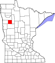
Townships Beaulieu | Bejou | Chief | Clover | Gregory | Heier | Island Lake | La Garde | Lake Grove | Little Elbow | Marsh Creek | Oakland | Pembina | Popple Grove | Rosedale | Twin Lakes
CDP Indian
reservationsCategories:- Minnesota counties
- Mahnomen County, Minnesota


Wikimedia Foundation. 2010.