- Clearwater County, Minnesota
-
Clearwater County, Minnesota 
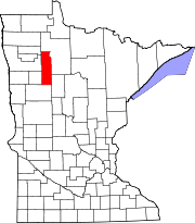
Location in the state of Minnesota
Minnesota's location in the U.S.Founded December 20, 1902, 1902 [1] Named for Clearwater Lake and Clearwater River Seat Bagley Largest city Bagley Area
- Total
- Land
- Water
1,029.79 sq mi (2,667 km²)
994.71 sq mi (2,576 km²)
35.08 sq mi (91 km²), 3.41%Population
- (2010)
- Density
8,695
8/sq mi (3/km²)Time zone central : -6/-5 Website www.co.clearwater.mn.us Clearwater County is a rural county located in the U.S. state of Minnesota. As of 2010, the population was 8,695.[1] Its county seat is Bagley[2]. Clearwater County is home to Lake Itasca, the source of the Mississippi River. Portions of the Red Lake and White Earth Indian reservations extend into the county.
Contents
Geography
According to the 2000 census, the county has a total area of 1,029.79 square miles (2,667.1 km2), of which 994.71 square miles (2,576.3 km2) (or 96.59%) is land and 35.08 square miles (90.9 km2) (or 3.41%) is water.[3]
Major highways
Adjacent counties
- Beltrami County (northeast)
- Hubbard County (southeast)
- Becker County (south)
- Mahnomen County (southwest)
- Polk County (northwest)
- Pennington County (northwest)
Demographics
Historical populations Census Pop. %± 1910 6,870 — 1920 8,569 24.7% 1930 9,546 11.4% 1940 11,153 16.8% 1950 10,204 −8.5% 1960 8,864 −13.1% 1970 8,013 −9.6% 1980 8,761 9.3% 1990 8,309 −5.2% 2000 8,423 1.4% 2010 8,695 3.2% U.S. Decennial Census As of the census[4] of 2000, there were 8,423 people, 3,330 households, and 2,287 families residing in the county. The population density was 8 people per square mile (3/km²). There were 4,114 housing units at an average density of 4 per square mile (2/km²). The racial makeup of the county was 89.26% White, 0.19% Black or African American, 8.58% Native American, 0.25% Asian, 0.01% Pacific Islander, 0.24% from other races, and 1.47% from two or more races. 0.77% of the population were Hispanic or Latino of any race. 43.6% were of Norwegian, 15.6% German, 6.5% Swedish and 6.2% American ancestry according to Census 2000.
There were 3,330 households out of which 30.60% had children under the age of 18 living with them, 56.80% were married couples living together, 7.50% had a female householder with no husband present, and 31.30% were non-families. 27.90% of all households were made up of individuals and 14.50% had someone living alone who was 65 years of age or older. The average household size was 2.48 and the average family size was 3.02.
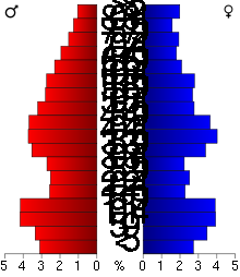 Age pyramid of county residents based on 2000 U.S. census data.
In the county the population was spread out with 26.00% under the age of 18, 7.60% from 18 to 24, 24.60% from 25 to 44, 24.30% from 45 to 64, and 17.50% who were 65 years of age or older. The median age was 40 years. For every 100 females there were 101.10 males. For every 100 females age 18 and over, there were 100.30 males.
The median income for a household in the county was $30,517, and the median income for a family was $39,698. Males had a median income of $29,338 versus $20,417 for females. The per capita income for the county was $15,694. About 11.00% of families and 15.10% of the population were below the poverty line, including 18.90% of those under age 18 and 18.20% of those age 65 or over.
Localities
Cities Townships CDPs Unorganized Ghost town Climate and weather
Bagley, Minnesota Climate chart (explanation) J F M A M J J A S O N D 0.716-50.72200.935141.65329366424.674513.979553.278522.968432.45432135180.6212Average max. and min. temperatures in °F Precipitation totals in inches Source: The Weather Channel[5] Metric conversion J F M A M J J A S O N D 18-9-2117-6-18232-104112-276196117231110026138226117320661120242-816-6-17Average max. and min. temperatures in °C Precipitation totals in mm In recent years, average temperatures in the county seat of Bagley have ranged from a low of −5 °F (−21 °C) in January to a high of 79 °F (26 °C) in July, although a record low of −53 °F (−47 °C) was recorded in February 1996 and a record high of 103 °F (39 °C) was recorded in August 1976. Average monthly precipitation ranged from 0.64 inches (16 mm) in December to 4.62 inches (117 mm) in June.[5]
See also
References
- ^ "2010 Census Redistricting Data (Public Law 94-171) Summary File". American FactFinder. United States Census Bureau. http://factfinder2.census.gov/faces/tableservices/jsf/pages/productview.xhtml?pid=DEC_10_PL_GCTPL2.ST05&prodType=table. Retrieved 25 April 2011.
- ^ "Find a County". National Association of Counties. http://www.naco.org/Counties/Pages/FindACounty.aspx. Retrieved 2011-06-07.
- ^ "Census 2000 U.S. Gazetteer Files: Counties". United States Census. http://www.census.gov/tiger/tms/gazetteer/county2k.txt. Retrieved 2011-02-13.
- ^ "American FactFinder". United States Census Bureau. http://factfinder.census.gov. Retrieved 2008-01-31.
- ^ a b "Monthly Averages for Bagley, Minnesota". The Weather Channel. http://www.weather.com/weather/wxclimatology/monthly/graph/USMN0043. Retrieved 2011-11-06.
External links

Polk County and Pennington County Beltrami County 
 Clearwater County, Minnesota

Mahnomen County Becker County Hubbard County Municipalities and communities of Clearwater County, Minnesota Cities Bagley | Clearbrook | Gonvick | Leonard | Shevlin
Townships CDPs Unorganized
territoriesUnincorporated
communitiesIndian
reservationsFootnotes ‡This populated place also has portions in an adjacent county or counties
Categories:- Minnesota counties
- Clearwater County, Minnesota
- Minnesota counties on the Mississippi River


Wikimedia Foundation. 2010.