- Mille Lacs County, Minnesota
-
Mille Lacs County, Minnesota 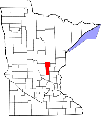
Location in the state of Minnesota
Minnesota's location in the U.S.Founded May 23, 1857 [1] Named for Mille Lacs Lake Seat Milaca Largest city Princeton Area
- Total
- Land
- Water
681.77 sq mi (1,766 km²)
574.47 sq mi (1,488 km²)
107.30 sq mi (278 km²), 15.74%Population
- (2010)
- Density
26,097
39/sq mi (15/km²)Time zone Central: UTC-6/-5 Website www.co.mille-lacs.mn.us Mille Lacs County (pronunciation: /mɨlˈlæks/ məl-laks) is a county located in the U.S. state of Minnesota, founded in 1857.[2] As of 2010, the population was 26,097.[3] Its county seat is Milaca[4]. A portion of the Mille Lacs Indian Reservation is in the county.
Contents
Name
The name Mille Lacs, meaning "thousand lakes" in French, comes from Mille Lacs Lake (French: Grand lac du Pays des Mille Lacs), largest lake in the Brainerd Lakes Area as the area was called "Region of Thousand Lakes" (Pays des Mille Lacs) in French.[5]
History
Mille Lacs County was organized on May 23, 1857 cleaving off the eastern-most portion of Benton County, Minnesota. The original Mille Lacs County consisted of the portion of the contemporary Mille Lacs County east of the west branch of the Rum River and two townships now part of Isanti County, adjacent to Mille Lacs County. In 1858, the 12 townships forming the contemporary southern 10 townships of Mille Lacs County and the 2 northwestern townships in Isanti County were organized apart from either Benton or Mille Lacs County to form Monroe County, leaving the northern "Square Top-knot" as the Mille Lacs County. In 1860, Monroe and Mille Lacs Counties merged. Shortly thereafter, the two southeastern townships were transferred to Isanti County, forming the contemporary boundaries for the county.
Geography
According to the 2000 census, the county has a total area of 681.77 square miles (1,765.8 km2), of which 574.47 square miles (1,487.9 km2) (or 84.26%) is land and 107.30 square miles (277.9 km2) (or 15.74%) is water.[6]
Major highways
Adjacent counties
- Aitkin County (north)
- Kanabec County (northeast)
- Isanti County (southeast)
- Sherburne County (south)
- Benton County (southwest)
- Morrison County (west)
- Crow Wing County (northwest)
National protected area
Demographics
Historical populations Census Pop. %± 1860 73 — 1870 1,109 1,419.2% 1880 1,501 35.3% 1890 2,845 89.5% 1900 8,066 183.5% 1910 10,705 32.7% 1920 14,180 32.5% 1930 14,076 −0.7% 1940 15,558 10.5% 1950 15,165 −2.5% 1960 14,560 −4.0% 1970 15,703 7.9% 1980 18,430 17.4% 1990 18,670 1.3% 2000 22,330 19.6% 2010 26,097 16.9% U.S. Decennial Census 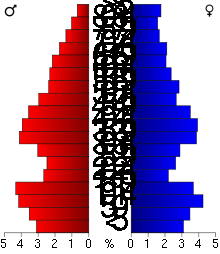 Age pyramid of county residents based on 2000 U.S. census data.
As of the census[7] of 2000, there were 22,330 people, 8,638 households, and 6,003 families residing in the county. The population density was 39 people per square mile (15/km²). There were 10,467 housing units at an average density of 18 per square mile (7/km²). The racial makeup of the county was 93.55% White, 0.27% Black or African American, 4.68% Native American, 0.21% Asian, 0.01% Pacific Islander, 0.22% from other races, and 1.05% from two or more races. 0.96% of the population were Hispanic or Latino of any race. 31.9% were of German, 14.4% Swedish and 14.2% Norwegian ancestry according to Census 2000.
There were 8,638 households out of which 32.20% had children under the age of 18 living with them, 55.50% were married couples living together, 9.50% had a female householder with no husband present, and 30.50% were non-families. 25.90% of all households were made up of individuals and 12.00% had someone living alone who was 65 years of age or older. The average household size was 2.53 and the average family size was 3.03.
In the county the population was spread out with 27.00% under the age of 18, 7.50% from 18 to 24, 26.90% from 25 to 44, 22.60% from 45 to 64, and 16.10% who were 65 years of age or older. The median age was 38 years. For every 100 females there were 98.00 males. For every 100 females age 18 and over, there were 96.10 males.
The median income for a household in the county was $36,977, and the median income for a family was $44,054. Males had a median income of $32,348 versus $22,036 for females. The per capita income for the county was $17,656. About 6.70% of families and 9.60% of the population were below the poverty line, including 10.90% of those under age 18 and 11.30% of those age 65 or over.
Cities and towns
Cities Townships Unincorporated communities Ghost Towns - Bayview
- Cove
- Estes Brook
- Long Siding
- Vineland (CDP) (Neyaashiing)
- Brickton
- Burnhelm Siding
- Esteville ‡
- Freer
- Johnsdale
- Soule's Crossing
- Stirling
† a small part of Princeton extends into Sherburne County.
‡ a small part of Esteville extended into Mille Lacs County from Benton County.See also
References
- ^ Minnesota Government Series, State Symbols
- ^ Minnesota House of Representatives
- ^ "2010 Census Redistricting Data (Public Law 94-171) Summary File". American FactFinder. United States Census Bureau. http://factfinder2.census.gov/faces/tableservices/jsf/pages/productview.xhtml?pid=DEC_10_PL_GCTPL2.ST05&prodType=table. Retrieved 25 April 2011.
- ^ "Find a County". National Association of Counties. http://www.naco.org/Counties/Pages/FindACounty.aspx. Retrieved 2011-06-07.
- ^ Upham, Warren. (1920; repr. 1991)Minnesota Place Names St. Paul: Minnesota Historical Society Press.
- ^ "Census 2000 U.S. Gazetteer Files: Counties". United States Census. http://www.census.gov/tiger/tms/gazetteer/county2k.txt. Retrieved 2011-02-13.
- ^ "American FactFinder". United States Census Bureau. http://factfinder.census.gov. Retrieved 2008-01-31.
External links
- Mille Lacs Messenger
- Mille Lacs County government’s website
- MNGenUSGen Web Site for Mille Lacs County, Minnesota
- Minnesota Department of Transportation map of Mille Lacs County

Crow Wing County Aitkin County Kanabec County Morrison County 
 Mille Lacs County, Minnesota

Benton County Sherburne County Isanti County Municipalities and communities of Mille Lacs County, Minnesota Cities 
Townships CDP Indian
reservationFootnotes ‡This populated place also has portions in an adjacent county or counties
Categories:- Minnesota counties
- Mille Lacs County, Minnesota


Wikimedia Foundation. 2010.