- St. Louis County, Minnesota
-
Saint Louis County, Minnesota 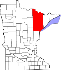
Location in the state of Minnesota
Minnesota's location in the U.S.Founded February 20, 1855 [1] Named for Saint Louis River Seat Duluth Largest city Duluth Area
- Total
- Land
- Water
6,859.91 sq mi (17,767 km²)
6,225.16 sq mi (16,123 km²)
634.75 sq mi (1,644 km²), 9.25%Population
- (2010)
- Density
200,226
32.21/sq mi (12.44/km²)Time zone Central: UTC-6/-5 Website www.co.st-louis.mn.us St. Louis County is a county located in the U.S. state of Minnesota. As of 2010, the population was 200,226.[1] Its county seat is Duluth. It is the largest county by total area in Minnesota, and the second largest in the United States east of the Mississippi River; in land area alone, after Aroostook County, Maine.[2] Major industries include pulpwood production and tourism. Surface mining of high-grade iron-ore remains an important part of the economy of the Iron Range. Parts of the Bois Forte and Fond du Lac Indian reservations are in the county.
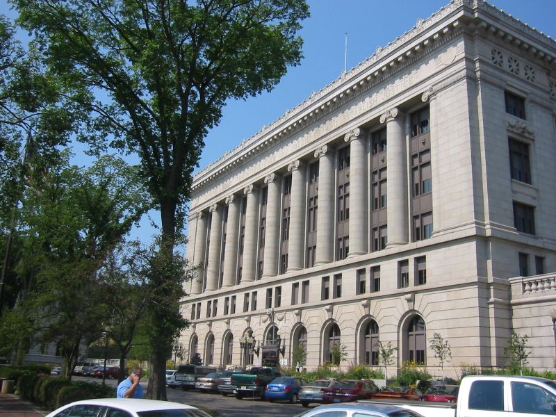
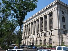 St. Louis County Courthouse
Contents
History
St. Louis County was founded on February 20, 1855 as Doty County and had its name changed to Newton County on March 3, 1855. It originally consisted of the area east and south of the St. Louis River, while the area east of the Vermilion River and north of the St. Louis River was part of Superior County. Superior County was renamed St. Louis County. Then on March 1, 1856, that St. Louis County became Lake County, and Newton County was renamed St. Louis County and had that eastern area added to it; it was also expanded westward by incorporating parts of Itasca County, which then also included most of Carlton County. On May 23, 1857 St. Louis County took its current shape when Carlton County was formed from parts of St. Louis and Pine Counties.
Geography
According to the 2000 census, the county has a total area of 6,859.91 square miles (17,767.1 km2), of which 6,225.16 square miles (16,123.1 km2) (or 90.75%) is land and 634.75 square miles (1,644.0 km2) (or 9.25%) is water.[3] By area, it is the largest county in Minnesota and the largest east of the Mississippi; by land area, the second largest east of the Mississippi.
St. Louis County is known for its spectacular natural beauty. Voyageurs National Park, established in 1975, is located in its northwestern corner, on the south shore of Rainy Lake, on the Ontario, Canada border, and is popular with canoeists, kayakers, other boaters and fishermen. The county also includes parts of Superior National Forest, established in 1909, and the Boundary Waters Canoe Area Wilderness within it on the U.S.-Canadian border, established in 1978. The BWCAW is a 1,090,000-acre (4,400 km2) wilderness area designated for fishing, camping, hiking, and canoeing and is one of the most visited wilderness areas in the United States. St. Louis County has over 500 lakes, including Rainy Lake, Kabetogama Lake, Namakan Lake, Sand Point Lake, and Crane Lake.
The "Hill of Three Waters" on the Laurentian Divide lies just north of Hibbing. Rain falling on this hill runs to three watersheds: Hudson Bay to the north, the Gulf of Saint Lawrence to the east (via Lake Superior), or the Gulf of Mexico to the south and west (via the Mississippi River).[4]
St. Louis County has one of the most important fresh-water ports in the United States, located in Duluth on Lake Superior.
The county encompasses part of the Iron Range, which has a significant taconite mining industry, particularly in the city of Hibbing.
Major highways
Adjacent counties
- Rainy River District, Ontario (north)
- Lake County (east)
- Douglas County, Wisconsin (southeast)
- Carlton County (south)
- Aitkin County (southwest)
- Itasca County (west)
- Koochiching County (northwest)
National protected areas
- Superior National Forest (part)
- Voyageurs National Park (part)
- Boundary Waters Canoe Area Wilderness (part)
Demographics
Historical populations Census Pop. %± 1860 406 — 1870 4,561 1,023.4% 1880 4,504 −1.2% 1890 44,862 896.0% 1900 82,932 84.9% 1910 163,274 96.9% 1920 206,391 26.4% 1930 204,596 −0.9% 1940 206,917 1.1% 1950 206,062 −0.4% 1960 231,588 12.4% 1970 220,693 −4.7% 1980 222,229 0.7% 1990 198,213 −10.8% 2000 200,528 1.2% 2010 200,226 −0.2% U.S. Decennial Census  Age pyramid of county residents based on 2000 U.S. census data.
As of the census[5] of 2000, there were 200,528 people, 82,619 households, and 51,389 families residing in the county. The population density was 32 people per square mile (12/km²). There were 95,800 housing units at an average density of 15 per square mile (6/km²). The racial makeup of the county was 94.86% White, 0.85% Black or African American, 2.03% Native American, 0.66% Asian, 0.03% Pacific Islander, 0.22% from other races, and 1.35% from two or more races. 0.80% of the population were Hispanic or Latino of any race. 17.0% were of German, 13.7% Norwegian, 12.1% Finnish, 9.7% Swedish, 6.0% Irish, and 5.3% Italian ancestry according to Census 2000.
27.60% of households included children under the age of 18, 49.30% were married couples living together, 9.40% had a female householder with no husband present, and 37.80% were non-families. 31.20% of all households consisted of individuals and 13.00% of individuals 65 years of age or older. The average household size was 2.32 and the average family size was 2.90.
The population spread by age was 22.40% under the age of 18, 11.40% from 18 to 24, 25.90% from 25 to 44, 24.30% from 45 to 64, and 16.10% who were 65 years of age or older. The median age was 39 years. For every 100 females there were 96.80 males. For every 100 females age 18 and over, there were 93.80 males.
The median income for a household in the county was $36,306, and the median income for a family was $47,134. Males had a median income of $37,934 versus $24,235 for females. The per capita income for the county was $18,982. About 7.20% of families and 12.10% of the population were below the poverty line, including 13.10% of those under age 18 and 8.90% of those age 65 or over.
Governance
Like all counties in Minnesota, Saint Louis is governed by an elected and nonpartisan board of commissioners. In Minnesota, county commissions usually have five members, but Saint Louis, Hennepin, and Ramsey counties have seven members. Each commissioner represents a district of equal population.
The county commission elects a chair who presides at meetings.
Commissioners as of January 2011:
District Commissioner In office since Current term expires 1st Frank Jewell 2011 December 31, 2014 2nd Steve O'Neil (chair) 2005 December 31, 2012 3rd Chris Dahlberg 2009 December 31, 2012 4th Mike Forsman 1995 December 31, 2014 5th Peg Sweeney 1997 December 31, 2012 6th Keith Nelson 2003 December 31, 2014 7th Steve Raukar 1989 December 31, 2014 Politics
Election results from statewide races[6] Year Office GOP DEM Others 2010 Governor 28.6% 61.8% 8.3% 2008 President 32.6% 65.1% 2.3% Senator 32.4% 54.6% 13.0% 2006 Governor 29.3% 64.6% 6.1% Senator 25.9% 70.9% 3.2% 2004 President 33.6% 65.2% 1.2% 2002 Governor 26.5% 59.9% 13.6% Senator 31.6% 65.4% 3.0% 2000 President 33.0% 59.8% 7.2% Senator 31.7% 63.3% 5.0% 1998 Governor 28.1% 47.3% 24.6% 1996 President 25.5% 60.6% 13.9% Senator 28.5% 64.7% 6.8% 1994 Governor 44.6% 53.0% 2.4% Senator 35.9% 56.9% 7.2% 1992 President 22.6% 56.8% 20.6% St. Louis County is considering doing a study about dividing the county into two counties.[7]
This county is by far the most reliable Democratic county in the state, as no Republican or independent won this county in any statewide election since 1992. The only time a Democrat obtained less than 50% of the vote was in 1998, when Jesse Ventura of the Reform ticket won statewide and gained 24% in the county. Since 1992, the only time when a Republican obtained over 34% of the vote was in the elections of 1994 (year of Republican Revolution) when the incumbent Independent-Republican governor won the statewide vote by a landslide vote of over 60%, and when the Independent-Republican senatorial candidate won election with 49% statewide, both of which is rare in Minnesota. Since 1994, the highest percentages a Republican obtained out of the county were 39.7% from Chip Cravaack's 2010 defeat of 36-year incumbent Congressman Jim Oberstar and 33.6% from George W. Bush's re-election of 2004.
Presidential elections
Also, Democrats have swept this county in the last 20 consecutive presidential elections. The last Republican to carry the county was Herbert Hoover in 1928.[8] In the last five Presidential elections the Republican candidate has never received more than 34% of the county's vote.[9]
Presidential Election Results 1992-2008 Year Democrat Republican 2008 65.10% 77,351 32.61% 38,742 2004 65.20% 77,958 33.55% 40,112 2000 59.78% 64,237 32.96% 35,420 1996 60.60% 60,736 25.50% 25,553 1992 56.80% 61,813 22.60% 24,579 Congress
St. Louis County is in Minnesota's 8th congressional district, represented by Republican Chip Cravaack. Cravaack was elected in 2010, defeating 36-year incumbent Jim Oberstar.
Cities and towns
Cities
Cities Unincorporated communities CDP Townships
Unorganized
See also
References
- ^ "2010 Census Redistricting Data (Public Law 94-171) Summary File". American FactFinder. United States Census Bureau. http://factfinder2.census.gov/faces/tableservices/jsf/pages/productview.xhtml?pid=DEC_10_PL_GCTPL2.ST05&prodType=table. Retrieved 25 April 2011.
- ^ Duluth News Tribune September 22, 2004, p. 2B. According to the U.S. Census Bureau, Arostook County has a smaller overall area but a greater land area.
- ^ "Census 2000 U.S. Gazetteer Files: Counties". United States Census. http://www.census.gov/tiger/tms/gazetteer/county2k.txt. Retrieved 2011-02-13.
- ^ "Lookout Mountain - Laurentian Divide Recreation Area - The Hill of Three Waters". wikimapia. 2007. http://wikimapia.org/5841044/Lookout-Mountain-Laurentian-Divide-Recreation-Area-The-Hill-of-Three-Waters. Retrieved 2009-03-28.
- ^ "American FactFinder". United States Census Bureau. http://factfinder.census.gov. Retrieved 2008-01-31.
- ^ http://uselectionatlas.org/RESULTS/
- ^ http://minnesota.publicradio.org/display/web/2007/07/27/countysplit/
- ^ http://geoelections.free.fr/USA/elec_comtes/1928.htm Geographie Electorale
- ^ The New York Times electoral map (Zoom in on Minnesota)
External links
- St. Louis County Government site - Link
- Duluth News Tribune site
- Duluth.com site
- Minnesota DOT maps of St. Louis County (Southern part of Southwest portion, Northern part of Southwest portion, Southern part of Southeast portion, Northern part of Southeast portion, Southern part of Northwest portion, Northern part of Northwest portion, Northeast portion)

Koochiching County Rainy River District, Ontario, Canada Itasca County 
Lake County  St. Louis County, Minnesota

Aitkin County Carlton County Douglas County, Wisconsin and Lake Superior Twin Ports, Minnesota-Wisconsin Core cities 

Surrounding
communities(over 10,000) (under 10,000) Counties  State of Minnesota
Topics - Index
- Cities
- Climate
- Colleges and universities
- Congressional districts
- Demographics
- Ecology
- Economy
- Geography
- Geology
- Governors
- High schools
- Historical Congressional delegations
- Historical Landmarks
- History
- Lakes
- Movies and television
- Music
- People
- Political parties
- Rivers
- School districts
- Scouting
- Sports
- State fair
- State parks
- Territory
- Townships
- Transportation
- Visitor Attractions
Regions Larger cities
pop. over 60,000Smaller cities
pop. over 10,000- Albert Lea
- Alexandria
- Andover
- Anoka
- Apple Valley
- Austin
- Bemidji
- Big Lake
- Blaine
- Brainerd
- Brooklyn Center
- Buffalo
- Champlin
- Chanhassen
- Chaska
- Cloquet
- Columbia Heights
- Cottage Grove
- Crystal
- East Bethel
- Edina
- Elk River
- Fairmont
- Faribault
- Farmington
- Fergus Falls
- Forest Lake
- Fridley
- Golden Valley
- Grand Rapids
- Ham Lake
- Hastings
- Hibbing
- Hopkins
- Hugo
- Hutchinson
- Inver Grove Heights
- Lakeville
- Lino Lakes
- Mankato
- Maplewood
- Marshall
- Mendota Heights
- Minnetonka
- Monticello
- Moorhead
- Mounds View
- New Brighton
- New Hope
- New Ulm
- North Branch
- North Mankato
- North St. Paul
- Northfield
- Oakdale
- Otsego
- Owatonna
- Prior Lake
- Ramsey
- Red Wing
- Richfield
- Robbinsdale
- Rosemount
- Roseville
- Sartell
- Sauk Rapids
- Savage
- Shakopee
- Shoreview
- South St. Paul
- St. Louis Park
- St. Michael
- St. Peter
- Stillwater
- Vadnais Heights
- Waconia
- West St. Paul
- White Bear Lake
- Willmar
- Winona
- Worthington
Counties - Aitkin
- Anoka
- Becker
- Beltrami
- Benton
- Big Stone
- Blue Earth
- Brown
- Carlton
- Carver
- Cass
- Chippewa
- Chisago
- Clay
- Clearwater
- Cook
- Cottonwood
- Crow Wing
- Dakota
- Dodge
- Douglas
- Faribault
- Fillmore
- Freeborn
- Goodhue
- Grant
- Hennepin
- Houston
- Hubbard
- Isanti
- Itasca
- Jackson
- Kanabec
- Kandiyohi
- Kittson
- Koochiching
- Lac qui Parle
- Lake
- Lake of the Woods
- Le Sueur
- Lincoln
- Lyon
- Mahnomen
- Marshall
- Martin
- McLeod
- Meeker
- Mille Lacs
- Morrison
- Mower
- Murray
- Nicollet
- Nobles
- Norman
- Olmsted
- Otter Tail
- Pennington
- Pine
- Pipestone
- Polk
- Pope
- Ramsey
- Red Lake
- Redwood
- Renville
- Rice
- Rock
- Roseau
- St. Louis
- Scott
- Sherburne
- Sibley
- Stearns
- Steele
- Stevens
- Swift
- Todd
- Traverse
- Wabasha
- Wadena
- Waseca
- Washington
- Watonwan
- Wilkin
- Winona
- Wright
- Yellow Medicine
Categories:- Minnesota counties
- St. Louis County, Minnesota


Wikimedia Foundation. 2010.