- Minnesota State Highway 61
-
For the route located in southeast and east-central Minnesota numbered 61, see U.S. Route 61 in Minnesota.
Trunk Highway 61
Route information Maintained by Mn/DOT Length: 148.843 mi[1] (239.540 km) Existed: 1991 – present Major junctions South end:  I-35 at Duluth
 CR 2 at Two Harbors
 MN 1 at Illgen City, near Silver Bay
 CR 12 at Grand Marais
North end:  Highway 61 near Grand Portage
Location Counties: Saint Louis, Lake, Cook Highway system Minnesota Trunk Highways
Interstate • U.S. • State
Inter-County • County roads • Legislative routes←  US 61
US 61MN 62  →
→Minnesota State Highway 61 is a highway in northeast Minnesota, which runs from the junction of Interstate Highway 35 and Minnesota 61 in Duluth (at 26th Avenue East) and continues northeast to its northern terminus at the U.S.-Canadian border near Grand Portage. The roadway becomes Ontario Highway 61 upon entering Canada at the Pigeon River Bridge, and terminates at the Trans-Canada Highway in Thunder Bay. Minnesota Highway 61 is 149 miles (240 km) in length.
The route is a scenic highway, following the North Shore of Lake Superior, and is part of the Lake Superior Circle Tour designation that runs through Minnesota, Ontario, Michigan, and Wisconsin.
This roadway was designated U.S. Highway 61 up until 1991. This highway (then U.S. 61) is the road that musician Bob Dylan referred to in the album and song Highway 61 Revisited.
The North Shore Scenic Drive is an All-American Road scenic byway designated route that follows Saint Louis County Road 61 / Lake County Road 61 / State Highway 61 (formerly U.S. 61) from the city of Duluth, Minnesota to the Canadian border near Grand Portage. The route stays close to the rocky North Shore of Lake Superior, offering spectacular vistas of the lake to the southeast as it skirts along the foothills of the Sawtooth Range to the northwest.
Contents
Route and features
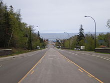 Highway 61 entering Grand Marais from the south
Minnesota Highway 61 serves as a northeast–southwest route in northeast Minnesota between Duluth, Two Harbors, Silver Bay, Grand Marais, and the Canadian border.
21 miles (34 km) of Highway 61 from Duluth to Two Harbors is a four-lane expressway officially designated the Arthur Rohweder Memorial Highway. There are no markers on the highway showing this designation, but there is a plaque at a wayside.
The roadway is located close to and in many places next to Lake Superior. Sights include forests, wildlife, cliffs, state parks, and a national monument.
Forests
Highway 61 passes through the Superior National Forest and the Grand Portage State Forest in Cook County.
State Parks
The following state parks are located on Highway 61:
- Gooseberry Falls State Park is located 13 miles (21 km) northeast of Two Harbors in Lake County.[2]
- Split Rock Lighthouse State Park is located in Lake County between Two Harbors and Silver Bay.[3]
- Tettegouche State Park is located in Lake County at the base of the Baptism River. The park is located immediately northeast of Silver Bay.[4]
- Temperance River State Park is located immediately northeast of Schroeder in Cook County.[5]
- Cascade River State Park is located in Cook County between Lutsen and Grand Marais.[6]
- Judge C. R. Magney State Park is located on the banks of the Brule River. The park is located 14 miles (23 km) northeast of Grand Marais in Cook County.[7]
- Grand Portage State Park is located in Cook County on the banks of the Pigeon River. The town of Grand Portage is nearby.[8]
Landmark
The Grand Portage National Monument is located adjacent to the town of Grand Portage on Highway 61.[9]
Features
A listing of more attractions located on or near Highway 61 is at North Shore (Lake Superior).
Termini
The southern terminus for Minnesota 61 is its junction with Interstate Highway 35 in Duluth in northeast Minnesota.
(Located in Duluth at 26th Avenue East, this is also the national northern terminus for I-35.)The northern terminus for Minnesota 61 is at the U.S.-Canadian border (near Grand Portage, Minn.), where it becomes Ontario Highway 61 upon entering Canada at the Pigeon River Bridge.
History


Minnesota Highway 61 was designated and signed in 1991. The roadway was originally part of U.S. Highway 61 from 1926 to 1991.
After construction of I-35 in the 1960s, U.S. 61 was co-signed with I-35 until 1991. During that year, U.S. 61 was decommissioned from the Canadian border south to its present day junction with I-35 at the city of Wyoming, Minn. (near Forest Lake). The section of U.S. 61 north of Duluth was re-designated Minnesota 61 that same year.
Minnesota 61 is one of three state marked highways to carry the same number as an existing U.S. marked highway within the state, the others being Highways 65 and 169.
Early History
Highway 61 (between Duluth and the Canadian border) was commissioned as part of U.S. Highway 61 in 1926, ready for use by 1929, and paved by 1940.
The section of Highway 61 from Hovland to the Pigeon River formerly ran inland, bypassing Grand Portage. The new highway alignment and border crossing were constructed in the early 1960s.
The Highway 61 expressway between Duluth and Two Harbors was constructed inland in the 1960s. The state then turned over management of the original U.S. 61 (between Duluth and Two Harbors) to Saint Louis and Lake counties. The two counties then re-designated this section as "County 61 / Scenic 61".
Major intersections
County Location Mile[1] Destinations Notes St. Louis Duluth 1.471  I-35 / LSCT
Southern end of LSCT concurrency 5.425 North Shore Drive (Scenic 61, to  CR 61)
Duluth Township 14.890  CR 42 (Homestead Road)
Lake Two Harbors 24.668  CR 61
CR 6126.189 CR 2 (4th Street)Silver Creek Township 28.526  CR 3
CR 3Beaver Bay 51.162  CR 4 (Lax Lake Road)
Silver Bay 54.315  CR 5 (Penn Boulevard / Outer Drive)
Illgen City 59.308 MN 1Little Marais 65.271  CR 6
CR 6Cook Tofte 82.682  CR 2 (Sawbill Trail)
Lutsen Township 92.528  CR 4
CR 4West Cook 101.704  CR 7
CR 7Grand Marais 110.256 CR 12 (Gunflint Trail)West Cook 110.725 CR 7 (5th Street)Hovland 128.867  CR 16 (Arrowhead Trail)
East Cook 134.643  CR 17
CR 17Grand Portage 143.353 CR 17 (Mile Creek Road)Pigeon River 150.870 Highway 61 / LSCTU.S.-Canadian border, LSCT continues into Ontario 1.000 mi = 1.609 km; 1.000 km = 0.621 mi See also
- North Shore (Lake Superior)
- Saint Louis County Road 61 – Scenic 61
- Lake County Road 61 – Scenic 61
References
- ^ a b "Trunk Highway Log Point Listing - Construction District 1" (PDF). Minnesota Department of Transportation. August 20, 2010. http://www.dot.state.mn.us/roadway/data/reports/logpoint/d1.pdf. Retrieved October 24, 2010.
- ^ Gooseberry Falls State Park - Link
- ^ Split Rock Lighthouse State Park - Link
- ^ Tettegouche State Park - Link
- ^ Temperance River State Park - Link
- ^ Cascade River State Park - Link
- ^ Judge C. R. Magney State Park - Link
- ^ Grand Portage State Park - Link
- ^ National Parks Service - Grand Portage National Monument - Link
- Adam Froehlig (December 20, 2002). Minnesota Highway 61. MN Highway Endings. Accessed August 27, 2004.
- Steve Riner (December 27, 2003). Details of Routes 51-75. Unofficial Minnesota Highways Page. Accessed August 27, 2004.
Categories:- State highways in Minnesota
- Lake Superior Circle Tour
- U.S. Route 61


Wikimedia Foundation. 2010.