- Ontario Highway 61
-
Highway 61
Route information Maintained by Ministry of Transportation of Ontario Length: 61.0 km[3] (37.9 mi) History: Established August 18, 1917[1]
Designated April 1, 1937[2]Major junctions South end:  MN 61 towards Grand Marais, MN
North end: 
 Highway 11 / Highway 17 – Thunder Bay
Highway system Ontario provincial highways
400-series • Former←  Highway 60
Highway 62  →
→King's Highway 61, commonly referred to as Highway 61 and historically known as the Scott Highway, is a provincially maintained highway in the Canadian province of Ontario. It connects the Pigeon River Bridge, where it crosses into the United States and becomes Minnesota State Highway 61, with a junction at Highway 11, Highway 17 and the Harbour Expressway in Thunder Bay. The highway forms a part of the Lake Superior Circle Tour.
Highway 61 was added to the highway system on April 1, 1937 with the amalgamation of the Department of Northern Development into the Department of Highways. Prior to that it was known as the Scott Highway. The bridge over the Pigeon River was originally known as The Outlaw, as it was constructed without formal approval of the Canadian or American governments.
Contents
Route description
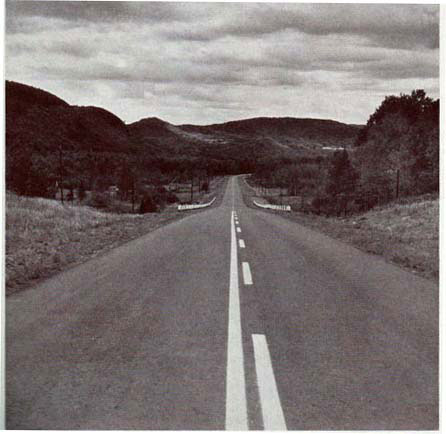
 Highway 61 passes by mountain ranges north of the Pigeon River
Highway 61 begins at the international border between Ontario and Minnesota, the Pigeon River; it continues as State Highway 61 to Duluth on the American side. It passes customs and curves to the north. Passing its former route at Highway 593, the highway curves east to avoid mountains.[4] It zig-zags around a range of mountains, eventually turning northward and passing to the west of Cloud Bay. The highway continues north for 20 kilometres (10 mi) through Neebing, pressed between mountain ranges on either side. It rises at Moose Hill, meets Highway 608 and enters one of the few agricultural areas in northwestern Ontario. Shortly thereafter, Highway 61 curves to the east, passing the southern terminus of Highway 130 along the way.[4] It then enters the outskirts of Thunder Bay.
The highway passes Chippewa Road, its former route through Thunder Bay, and returns to its northward orientation. It officially enters the city as it crosses the Kaministiquia River. Continuing north, the highway swerves east at Thunder Bay International Airport and crosses Arthur Street. North of Arthur Street, the highway is also known as the Thunder Bay Expressway. It continues north for 3 km (1.9 mi) and ends at the Harbour Expressway and Trans-Canada Highway.
The northernmost section in Thunder Bay is a four-lane, undivided expressway. The remainder of Highway 61 is a conventional two-lane highway.[5] Traffic volumes along the southern portion of the highway are generally low, with an Annual Average Daily Traffic (AADT) of 1,000 vehicles. This increases progressing north; within Thunder Bay the AADT peaks at 17,200 vehicles.[3]
Highway 61 also forms a small portion of the Lake Superior Circle Tour, a tourist route of highways following the shoreline of Lake Superior. To the south, the tour continues along Minnesota State Highway 61; to the north it continues along Highway 17 towards Sault Saint Marie.[6]
History
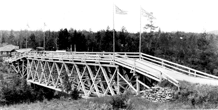
 The original bridge over the Pigeon River was known as The Outlaw
The road that would become Highway 61 was first constructed in 1916. The Pigeon River Timber Company had cleared lands surrounding the towns of Port Arthur and Fort William, but no road existed to connect to locations outside. A narrow bush trail reached as far as the Pigeon River, and so was chosen as the route for the new road. The Department of Mines and Resources agreed to fund the project, and citizens proceeded to lay a new road as far as the river. This road was initially known as the "Scott Highway" after lumberman William Scott.[7] On the opposite shore, the Cook County and Minnesota State authorities constructed a new road north from Grand Marais. The roads were completed, but no bridge existed to connect them.[8]
In response, the Rotary Clubs of Port Arthur and Duluth met to discuss a solution. As an international crossing, any bridge over the river would require federal approval. Both sides agreed that the approval process would be too slow, and decided to construct the bridge regardless. "The Outlaw" bridge was opened on August 18, 1917, finally permitting travel between Ontario and Minnesota.[1] The bridge and the Canadian road approaching it fell under the jurisdiction of the Department of Highways (now the Ministry of Transportation) on April 1, 1937, and the Scott Highway became Highway 61.[2] The Outlaw was rebuilt as a steel truss structure in 1930 following several accidents.
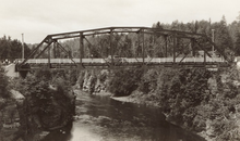 "The Outlaw" was replaced by this truss bridge in 1930. This bridge would remain in place until the new crossing opened in 1964.
By 1962, construction was underway to bypass the inland route of the highway as well as the bridge.[9] This bypass opened on November 1, 1963,[10] the American approach rebuilt along the shore of Lake Superior, and a new bridge constructed over the river 10 km (6.2 mi) to the east.[1] Highway 61 was realigned as a result; the former route was redesignated as Ontario Highway 593 on September 1, 1964.[10]
In 1963, Charles MacNaughton, minister of the Department of Highways, announced plans for the Lakehead Expressway to be built on the western edge of the twin cities of Port Arthur and Fort Williams (which amalgamated in 1970 to form Thunder Bay).[11] Construction began in the late 1960s and progressed rapidly.[12][13] Following its completion, Highway 61 was rerouted along it as far north as Arthur Street. The former route followed Chippewa Road, turned north on James Street and then east on Frederica Street. From there, it turned north along Ford Street and followed it and Kingsway to Highway 11 and Highway 17 at Arthur Street. This route was renumbered as Highway 61B.[6]
Beginning in 1991, Highway 61 was completely reconstructed south of Thunder Bay to the border in preparation for the 1995 World Nordic Ski Championships. This involved replacing eight bridges, improving sightlines, the addition of five passing lanes and paved shoulders throughout the length of the highway.[14] Recent years have seen Highway 61 improved considerably within Thunder Bay.[15] The highway was extended 3 km (1.9 mi) to the north on August 17, 2007 when the Shabaqua Highway opened, redirecting Highway 11 and Highway 17 off Arthur Street.[16]
Major intersections
The following table lists the major junctions along Highway 61. In addition, it includes some minor junctions that are noted by the Ministry of Transportation of Ontario.[3] The entirety of Highway 61 is located within Thunder Bay District.[4]
Location km[3] Destinations Notes Pigeon River Bridge over the Pigeon River
 Highway 61 continues into Minnesota as State Highway 61
 Neebing, Ontario 3.1  Highway 593
35.3 Highway 608 40.0  Highway 130
46.5 Little Norway Road Thunder Bay 52.8 Chippewa Road 54.5 Broadway Avenue 56.9 Neebing Avenue
Princess Street58.0 Arthur Street Former routing for Highways 11 and 17 61.1 Highway 11 / Highway 17
Harbour ExpresswayHighway 61 ends; road continues as Highways 11 and 17 See also
- Highway 61, a 1991 film by Canadian director Bruce McDonald.
References
- Sources
- ^ a b c Wurzer, Cathy (2008). Tales of the Road: Highway 61. Minnesota Historical Society Press. pp. 10–12. ISBN 978-0-87351-626-6. http://books.google.ca/books?id=FQMHmql5_XAC&lpg=PA11&ots=_y9fHtLkEz&dq=August%2018%2C%201917%20Outlaw%20bridge&pg=PA10#v=onepage&q=August%2018,%201917%20Outlaw%20bridge&f=false. Retrieved September 8, 2010.
- ^ a b Shragge 1984, p. 71.
- ^ a b c d Ministry of Transportation of Ontario (2007). "Annual Average Daily Traffic (AADT) counts". http://www.raqsb.mto.gov.on.ca/techpubs/TrafficVolumes.nsf/tvweb?OpenForm&Seq=5. Retrieved April 14, 2010.
- ^ a b c Peter Heiler Ltd (2010). Ontario Back Road Atlas (Map). Cartography by MapArt. p. 107, section H–J8. ISBN 978-1-55198-226-7.
- ^ Google, Inc. Google Maps – Highway 61 Length and Route (Map). Cartography by Google, Inc. http://maps.google.com/maps?f=d&source=s_d&saddr=ON-61+N&daddr=48.405399,-89.287738&hl=en&geocode=Fbxw3AIdfgep-g%3BFZeb4gIdxpOt-g&mra=mift&mrsp=0&sz=18&sll=48.000914,-89.585105&sspn=0.002032,0.005665&ie=UTF8&ll=48.234736,-89.346313&spn=0.517733,1.450195&t=h&z=10. Retrieved September 12, 2010.
- ^ a b Government of Ontario (1990). Ontario Official Road Map (Map). Cartography by Geomatics Office.
- ^ Bray, Robert Matthew; Epp, Ernest, eds (1984). A Vast and magnificent land. Lakehead University. p. 61. ISBN 978-0886630010.
- ^ Angus, Jim (July 7, 2010). "District 5580". Rotary Global History Fellowship. http://www.rotaryfirst100.org/districts/districts/5580.htm. Retrieved September 8, 2010.
- ^ Ontario Department of Highways (1962). Ontario Road Map (Map). Cartography by C.P. Robins. Section J13–14.
- ^ a b AADT Traffic Volumes 1955–1969 And Traffic Collision Data 1967–1969. Ontario Department of Highways. 1969. p. 135.
- ^ Engineering and Contract Record (Report). 76. Hugh C. MacLean publications. 1963. p. 121. http://books.google.ca/books?ei=N6OLTJyJIcKC8gavr9D1CQ&ct=result&id=lHjmAAAAMAAJ&dq=%22Lakehead+Expressway%22&q=%22Mr.+MacNaughton#search_anchor. Retrieved September 12, 2010. "The long awaited Lakehead Expressway moved to the brink of reality when Ontario Highways Minister Charles S. MacNaughton announced a new cost-sharing formula for the twin cities portion. This fixes the expressway cost at $15,770,000."
- ^ Civic Administration. 20. Maclean–Hunter. 1968. p. 89. http://books.google.ca/books?ei=N6OLTJyJIcKC8gavr9D1CQ&ct=result&id=4cfnAAAAMAAJ&dq=%22Lakehead+Expressway%22&q=%22Lakehead+Expressway%22#search_anchor. Retrieved September 11, 2010.
- ^ Proceedings of the convention (Report). Canadian Good Roads Association. 1969. p. 66. http://books.google.ca/books?ei=yKKLTOkHgf7wBqiysJQL&ct=result&id=RJbVAAAAMAAJ&dq=Proceedings+of+the+1969+convention+good+roads&q=Lakehead+Expressway#search_anchor. Retrieved September 12, 2010.
- ^ Northern Transportation Construction Projects 1991-92 (Report). Ministry of Transportation of Ontario. May 1991. p. 10. ISSN 0822-1480.
- ^ Ministry of Transportation of Ontario. "Northern Highways Program - Rehabilitation Projects, 2010 to 2012". Government of Ontario. http://www.mto.gov.on.ca/english/pubs/highway-construction/northern-highway-2008/partK.shtml. Retrieved September 12, 2010.
- ^ Kelly, Jim. "New stretch of Highway 11/17 to open today". The Chronicle–Journal (Thunder Bay). http://www.chroniclejournal.com/content/news/local/2007/08/17/new-stretch-highway-1117-open-today. Retrieved March 12, 2011.
- Bibliography
- Shragge, John; Bagnato, Sharon (1984). From Footpaths to Freeways. Ontario Ministry of Transportation and Communications, Historical Committee. ISBN 0-7743-9388-2.
The King's Highways of Ontario Current highwaysFormer highways- 2A
- 2B
- 2S
- 3B
- 4A
- 5A
- 7B
- 8A
- 12B
- 14
- 15A
- 18
- 18A
- 22
- 24A
- 25
- 27
- 29
- 30
- 31
- 32
- 35A
- 35B
- 36
- 38
- 39
- 40B
- 42
- 43
- 44
- 45
- 46
- 47
- 48B
- 50
- 51
- 52
- 53
- 54
- 55
- 56
- 57
- 59
- 68
- 70
- 73
- 74
- 75
- 76
- 78
- 79
- 80
- 81
- 82
- 83
- 84
- 86
- 87
- 88
- 90
- 91
- 92
- 95
- 96
- 97
- 98
- 99
- 100
- 103
- 104
- 106
- 107
- 109
- 110
- 111
- 114
- 116
- 117
- 119
- 120
- 121
- 122
- 123
- 126
- 128
- 131
- 133
- 134
- 135
- 136
- 169
- 400A
- 401A
County roads in Ontario · Ontario numbered highways · Expressways and 400-series highways · King's Highways · Secondary highways · Tertiary and 7000-series highways · List of Ontario provincial highways · List of former provincial highways in Ontario · Highways in Ontario · List of Ontario expressways · Trans-Canada Highway · Connecting Link · Emergency Detour RouteCategories:- Ontario provincial highways
- Roads in Thunder Bay District


Wikimedia Foundation. 2010.