- Ontario Highway 17
-
Highway 17

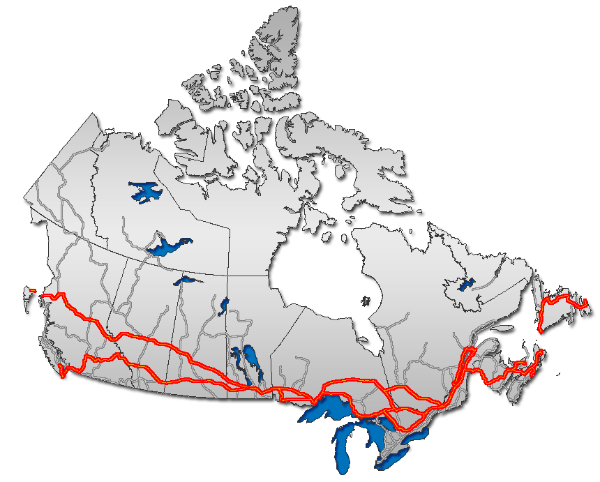
Trans-Canada Highway 
Route information Length: 1,964.0 km[2] (1,220 mi) Existed: February 26, 1920[1] – present Major junctions West end:  PTH 1 towards Winnipeg
 Highway 71 – Kenora
 Highway 61 – Thunder Bay
 Highway 11 – Nipigon
 Highway 101 – Wawa
 To I-75 in Sault Ste. Marie
 Highway 6 – McKerrow
 Highway 69 – Sudbury
Highway 11 – North Bay
 Highway 41 – Pembroke
 Highway 60 – Renfrew
East end:  Highway 417 near Arnprior
Location Major cities: Kenora, Dryden, Ignace, Thunder Bay, Wawa, Sault Ste. Marie, Sudbury, North Bay, Mattawa, Petawawa, Pembroke, Arnprior Highway system Ontario provincial highways
400-series • Former←  Highway 16
Highway 19  →
→King's Highway 17, more commonly known as Highway 17, is a provincially maintained highway and the primary route of the Trans-Canada Highway through the Canadian province of Ontario. It begins at the Manitoba border 50 km (31 mi) west of Kenora and ends south of Arnprior at the western terminus of Highway 417, 1,964.0 km (1,220.4 mi) to the east. This makes it Ontario's longest highway.[note 1]
The highway once extended even farther to the Quebec border in East Hawkesbury with a peak length of about 2,180 km (1,350 mi). However, a section of Highway 17 "disappeared" when the Ottawa section of it was upgraded to the freeway Highway 417 in 1971. Highway 17 was not re-routed through Ottawa, nor did it share numbering with Highway 417 to rectify the discontinuity, even though Highway 417 formed a direct link between the western and eastern sections of Highway 17. However, from East Hawkesbury to Ottawa, Highway 17 retained the Trans-Canada Highway routing and signs until it met up again and merged with Highway 417 until 1997, when Highway 17 through Ottawa was downloaded. The Trans-Canada Highway designation now extends along all of Highway 417.
Contents
History
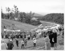 The official ceremony for the opening of the Lake Superior Circle Tour and the Trans-Canada Highway was held on September 17, 1960 near Wawa
The route which would become Highway 17 was first designated as a provincial highway on February 26, 1920, when two separate highways were added to the system.[1] The first travelled between Ottawa and Pembroke, while the second travelled between Ottawa and Point Fortune at the Ontario–Quebec border. Both these routes became known as Highway 17 in the summer of 1925.[3] By 1930, a road existed between Pembroke and Sault Saint Marie, although it was not part of Highway 17 at the time.[4] This road was constructed beginning in 1926 with the signing of the Department of Northern Development (DND) Act.[1] On April 1, 1937, the DND was absorbed into the Department of Highways, and the road west of Pembroke became an extension of Highway 17.[5]
The portion of Highway 17 over the top of Lake Superior was constructed in the late 1950s as a result of the Trans-Canada Highway Act. Amongst some of the most difficult terrain encountered in Canada, engineers blasted 2,730,000 cubic yards of rock, removed 7,825,000 cubic yards of earth, and cleared 6.97 square kilometres (1,720 acres) of forest in order to bridge the 266 kilometres (165 mi) of wilderness known as "the Gap".[6] The Gap was completed and opened to traffic on September 17, 1960, uniting the two segments and completing the route of Highway 17 from the Manitoba border to the Quebec border.
The last gravel stretch of Hwy 17 was located west of Ignace and was paved in 1967.
During the 1950s, the Greber Plan in Ottawa called for the creation of numerous parkways and divided highways through the burgeoning city. One of these, known as The Queensway, was a grade-separated freeway that would bypass Highway 17. This freeway was gradually constructed throughout the 1960s.
On April 1, 1997, the Ministry of Transportation of Ontario (MTO) transferred the responsibility of maintenance and upkeep along 14.2 km (8.8 mi) of Highway 17 east of "the split" with Ontario Highway 417 to Trim Road (Regional Road 57), a process commonly referred to as downloading. The Region of Ottawa–Carleton designated the road as Regional Road 174. Despite the protests of the region that the road served a provincial purpose, a second round of transfers saw Highway 17 within Ottawa downloaded entirely on January 1, 1998. An additional 12.8 km (8.0 mi) was added to the length of Regional Road 174.[7] Highway 17 was also downloaded within the United Counties of Prescott and Russell, where it was redesignated as County Road 17. [8]
Route description
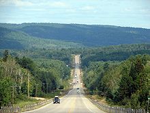
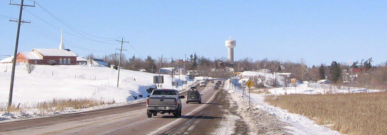
Highway 17 crosses some of the most remote regions of Ontario. Although there are several settlements established throughout its length, the distance between gas stations can often exceed several hundred kilometres. Despite the isolation of the highway, it is well-travelled throughout its length.[2] The section of Highway 17 north of Lake Superior is regarded as one of the most scenic drives in the province.[9]
Manitoba to Nipigon
Highway 17 begins at the border between Ontario and Manitoba, where a large installation greets drivers in both directions. The highway is two lanes wide and travels over and between the surface features of the Canadian Shield; further west into Manitoba the highway widens into a four lane divided expressway. To the east, the highway travels through thick boreal forest towards Keewatin, where the grade-separated Kenora Bypass, Highway 17A, splits to the north. Through the town of Kenora, Highway 17 is signed, but maintained under a connecting link agreement between the town and the province. Full provincial maintenance resumes at the eastern town limits. Further east, the highway merges with the Kenora Bypass. It meets the northern terminus of Highway 71, then makes a gradual eastward journey through the lake-dotted Kenora District to the town of Dryden. Here the highway encounters one of the few agriculturally-sustainable areas of northern Ontario. The highway begins to zig-zag southeasterly, passing through several minor settlements before entering the mining town of Ignace. Shortly thereafter, it begins to curve to the south. It meets Highway 11 475 km (295 mi) east of the Manitoba border.
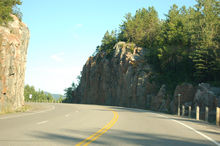 Highway 17 divides mountains on its journey along the north shore of Lake Superior
The two highways travel concurrently towards Thunder Bay at the western lakehead of Lake Superior. Though it originally travelled through what was then the twin-cities, the highway bypasses to the northwest on the at-grade Thunder Bay Expressway.
Nipigon to Sudbury
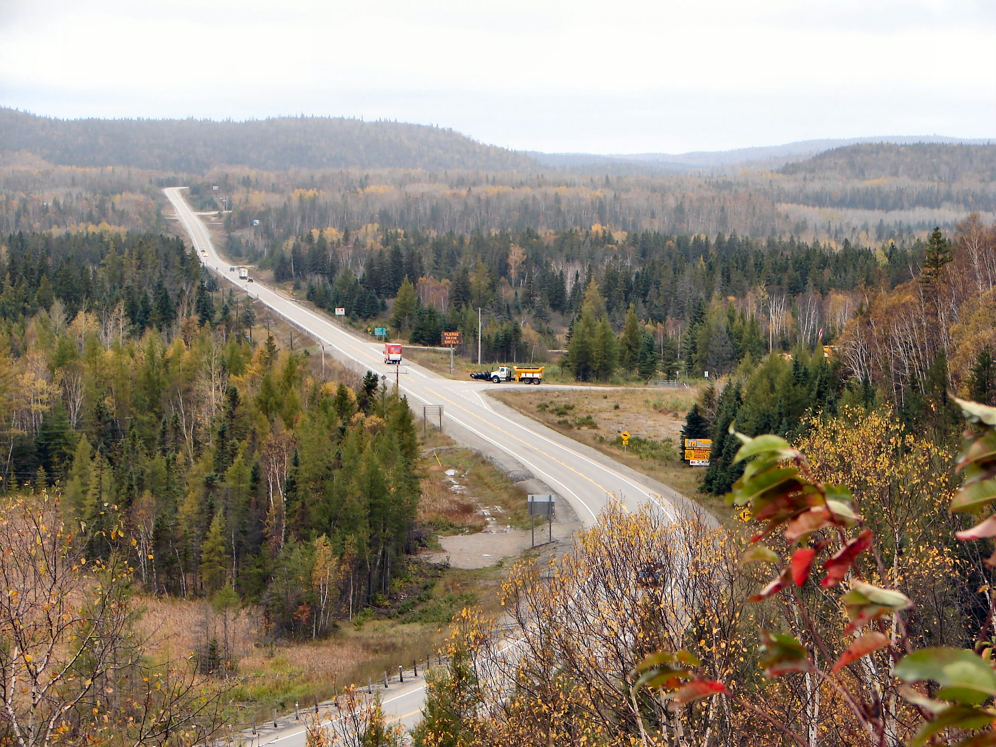
Within Nipigon, Highway 11 and Highway 17 cross the Nipigon River. Along with the railway crossing immediately to the south, and another on the northern shore of Lake Nipigon, this forms the narrowest bottleneck in Canada between the Atlantic and Pacific oceans.[citation needed] On the eastern shore of the river, Highway 11 separates and travels north towards Geraldton and Hearst. Highway 17 continues east along the northern shore of Lake Superior. Near White River, the highway enters Algoma District and turns southward. It meets the western terminus of Highway 101 near Wawa, which provides for a shorter route to Sudbury via the Sultan Industrial Road.
 Highway 17 near Wawa
South of Wawa, the highway enters Lake Superior Provincial Park. After proceeding through several mountain ranges, and crossing numerous rivers, the highway enters Sault Ste. Marie. Here a border crossing into the United States is provided via the Sault Ste. Marie International Bridge, which connects with I-75 in Michigan. As the highway exits Sault Ste. Marie to the east, a newly constructed segment of four lane divided highway branches north; Highway 17B (the only remaining business route of Highway 17 in service) continues east through Garden River. The divided highway bypasses Garden River and passes east of Echo Bay before curving south and merging with Highway 17B.
Shortly thereafter, it turns to the east and travels along the North Channel of Lake Huron towards Sudbury, passing through numerous small towns, including Thessalon, Blind River, Massey and McKerrow. At Sudbury, the highway widens into a freeway through the Walden area of the city until reaching the Southwest / Southeast Bypass at Lively, where it narrows again to a Super 2 road. This segment is currently undergoing an environmental assessment, with plans to upgrade it to a full freeway in the next ten years.
Sudbury to Arnprior
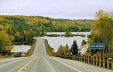 Highway 17 meets the Ottawa River in Deux Rivieres
Highway 17 passes to the south of the urban centre of Sudbury. It meets Highway 69 at an interchange; with the conversion of Highway 69 to Highway 400 underway, through-traffic will be transferred to a new interchange several kilometres further north, while the existing alignment of Highway 69 will become an extension of Municipal Road 46. At this interchange, the Southwest and Southeast Bypasses meet, and for just over a kilometre, Highway 17 is a divided four-laned freeway.
The Super 2 continues northeast to meet the original alignment of Highway 17 east of downtown Sudbury. Here it turns east and travels through the city's outlying neighbourhoods of Coniston and Wahnapitae; a new freeway alignment of this route is currently in the planning stages.
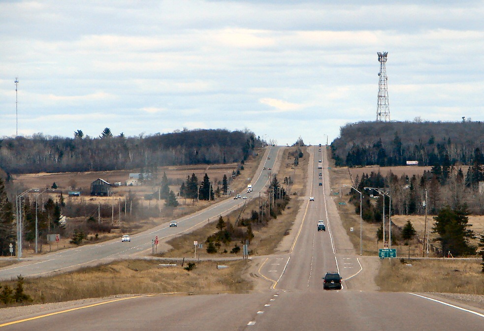
The highway route passes through the rural municipalities of Markstay-Warren and West Nipissing before reaching North Bay, where it follows an undivided four-lane expressway alignment, with reduced but not full control of access, through the city of North Bay. For 4.1 kilometres from Algonquin Avenue to the Twin Lakes area, the route is once again concurrent with Highway 11. At the northern end of this concurrency, Highway 11 travels north and wraps westward and south to Nipigon; at the southern end, it continues southward towards Toronto, while Highway 17 turns east toward the Ottawa Valley. An at-grade intersection with Highway 63 is located at approximately the midpoint of the concurrency.
 Highway 17 looking east towards Stonecliffe
East of North Bay, Highway 17 meets Highway 94, the last connection into southern Ontario for nearly 200 km (120 mi), thereafter travelling alongside the Mattawa River to its confluence with the Ottawa River in Mattawa, where drivers must turn at a junction with Highway 533. The highway then parallels the Ottawa River through a mountainous region, first passing through the villages of Stonecliffe and Rolphton before arriving in Deep River, a planned community developed as part of the Manhattan Project. It then passes through Chalk River and enters Canadian Forces Base Petawawa.
Beginning at the southern end of the army base, Highway 17 follows the Pembroke Bypass, bypassing west of Petawawa and Pembroke, where it intersects Highway 41. The bypass ends at Renfrew County Road 40, north of Muskrat Lake. The highway then travels south through the town of Cobden. It follows a bypass east of Renfrew and meets Highway 60. Highway 17 curves east and travels towards Arnprior, which the highway bypasses south of. After crossing the Madawaska River, the highway divides and widens to four lanes, at which point Highway 17 ends and Highway 417 begins.
 One of the few short sections of 4-lane divided Highway 17 between Echo Bay and Desbarats
Business routes
Highway 17 used to have a number of business routes, all but one of which have been decommissioned. All were at one time the primary route of Highway 17 through their respective locations, and were given the business route designation following the construction or designation of a newer bypass alignment.
- Highway 17B (Ottawa)
- Highway 17B (North Bay)
- Highway 17B (Thessalon)
- Highway 17B (Sault Ste. Marie)
- Highway 17B (Thunder Bay)
Future
See also: Ontario Highway 417With all route planning studies now completed on Highways 11 and 69/400, in the latter half of the 2000s the Ministry of Transportation's planning branch began undertaking more active preparations for the eventual conversion of Highway 17 to freeway. Although no comprehensive conversion plan is currently in place, planning and construction projects are now underway at a number of locations along the highway.
Sault Ste. Marie MPP David Orazietti has spearheaded a petition to have the entire highway four-laned from Arnprior to Sault Ste. Marie,[10] similar to the campaign previously undertaken by his caucus colleague Rick Bartolucci regarding the extension of Highway 400. Cheryl Gallant, the federal Member of Parliament for Renfrew—Nipissing—Pembroke, has also advocated for the four-laning of the highway through the Ottawa Valley toward North Bay, and ultimately the entire length of the highway throughout Northern Ontario.[11]
A 2009 study commissioned by the forestry trade magazine The Working Forest, titled "A Vision for Ontario’s Trans Canada Highway, North Bay to the Manitoba Border", determined that it would cost the Ontario government $600 million per year over 25 years to convert the entire length of both Highway 17 and Highway 11 to freeway, suggesting that a comprehensive plan would be affordable and achievable if the provincial and federal governments could reach a cost-sharing agreement.[12]
Renfrew County
Studies are underway on the extension of Highway 417 through the Ottawa Valley region from its current terminus at Arnprior to Petawawa. From Arnprior to Haley Station and from Meath to Petawawa, the proposed freeway route largely follows the existing alignment — in these areas, the current highway route largely avoids existing communities, and thus a second set of lanes can be easily added alongside the existing route. Within the township of Whitewater Region, however, a new alignment is planned several kilometres east of the existing road in order to bypass communities such as Cobden.
North Bay
Planning studies have been completed for the conversion of Highway 17's alignment through North Bay to a full freeway, including an interchange with a new alignment of Highway 11 which would replace the existing Algonquin Avenue segment.[13] Studies commenced in early 2011 on an extension of the four-lane route easterly to Bonfield,[14] and further studies on the routes from Bonfield to Mattawa and from North Bay to Cache Bay are expected to begin later in 2011 or 2012.
Sudbury
As the extension of Highway 400 approaches Sudbury, with planned completion in 2017, the MTO began a route planning and environmental assessment study on Highway 17 easterly from the Highway 69 to Markstay in 2010;[15] studies for the segment from Highway 69 westerly to the existing freeway in Walden were completed in 2007. Current plans, though only initial, involve extending the terminus of the freeway segment of Highway 69, southeast of Sudbury, north to meet a new Highway 17 alignment. Portions of the Southeast Bypass will be utilized for this new freeway, but several possible corridors have been identified east of there.
A new three level interchange will be constructed between Highway 17 and the future Highway 400 near the Lake Laurentian Conservation Area.[16]
Preliminary route planning studies have also been completed on the freeway's westerly extension to McKerrow, near Espanola, but no construction schedule has been announced to date. However, the first phase of this route, extending the existing freeway from Municipal Road 55 in Sudbury for six kilometres further west through the Den-Lou neighbourhood, is currently in the detail design phase.
Sault Ste. Marie
At Sault Ste. Marie, the expressway segment currently ends six kilometres short of its eventual terminus at Black Road and Second Line, as an agreement has yet to be reached with the Batchawana First Nation regarding land use through Rankin. Completion of the segment is not currently expected until at least 2015. In the interim, highway traffic travels between the expressway and the current highway alignment through Sault Ste. Marie by means of the previously planned northerly extension of Trunk Road.[17]
The former segment of Highway 17 through Garden River was initially redesignated as part of Highway 638, although the Garden River First Nation disputed this designation and insisted that the highway be renamed Highway 17B. As of February 2009, the former route is now designated as Highway 17B. In February 2010, Garden River's band council publicly warned that they would consider imposing tolls on the routes of both Highway 17 and Highway 17B through their territory if the provincial government did not assist the council with a funding shortfall of approximately $1 million.[18]
In February 2011, the Ministry of Transportation announced that the expressway's current level intersection at Highway 638 in Echo Bay will be upgraded to a full interchange.[19]
Thunder Bay and Kenora
Construction started in 2004 on a westerly extension of Thunder Bay's Harbour Expressway, from the Thunder Bay Expressway to Vibert Road, intended to serve as a new alignment for Highways 11 and 17.[20]
In July 2008 the federal and provincial governments announced a $6.2 billion infrastructure program that makes the four-laning of Hwys. 11 and 17 near Kenora and Thunder Bay a priority. Engineering work on twinning 11/17 between Nipigon and Thunder Bay is to begin in 2008.[21] On May 1, 2009 the federal and provincial government announced that twinning of Highway 11/17 would begin in 2010.[22]
On May 15, 2009 the federal and provincial government also announced that twinning of Highway 17 at the Manitoba/Ontario border easterly toward Kenora would also begin in 2010.[23]
Major intersections
Major intersections are listed from west to east. Rail and river crossings noted by the MTO are included for remote areas.
Division Location km[2] Destinations Notes  Highway 17 continues west towards Winnipeg as Manitoba Highway 1
 Kenora District 0.0 Ontario–Manitoba boundary 29.5 Lindsay Road Kenora 37.6–39.6 Highway 17A (Kenora Bypass (western junction)) 40.4 Highway 641 (Laclu Road) 43.4–63.0 Keewatin / Kenora connecting link agreement 67.8–68.1 Highway 17A (Kenora Bypass (eastern junction)) 72.2 Highway 71 – Rainy River, Fort FrancesVermillion Bay 144.6 Highway 647 (Vermillion Bay Road) 146.6  Highway 105 (Red Lake Road)
160.9  Highway 594 (Five Acres Rest)
173.8 Highway 605 Dryden 185.1 Highway 665 north (Richan Road) 186.5 Dryden connecting link agreement begins 189.6 Highway 601 (Colonization Avenue North) 189.9 Highway 594 (Duke Street)191.3 Dryden connecting link agreement ends 194.6 Highway 601 (Airport Road) – Rice Lake Dinorwic 217.4  Highway 72
228.8 Highway 622 – Atikokan Borups Corners 238.3 Highway 603 – Dyment Ignace 297.0  Highway 599
307.2 Gulliver River bridge Thunder Bay District 366.1 Sheba CPR underpass 386.8 Little Firesteel River bridge Upsala 404.1 Inwood Provincial Park entrance Shabaqua 474.9 Highway 11 west – Fort Frances, Rainy RiverWestern end of Highway 11 concurrency Thunder Bay ~560.0 Eastern end of Highway 102 Southern End of Highway 527 Nipigon 655.0 Highway 11 east – Hearst, GeraldtonEastern end of Highway 11 concurrency 699.2 Little Gravel River bridge 730.4 Selim CPR underpass Schreiber 744.9 Quebec Street 748.6 Heron Bay CPR underpass 757.0 Aquasabon River bridge Terrace Bay 759.1 Terrace Bay CPR underpass 785.7 Steel River bridge 807.5 Little Pic River bridge 835.4 Peninsula Road – Marathon Formerly Highway 626 842.1 Highway 627 (Heron Bay Road) 875.3 Highway 614 (Manitouwadge Road) Algoma District White River 926.0 Highway 631 (Elgin Street) Wawa 1015.6 Highway 1011120.9 Montreal River bridge 1170.8  Highway 563 – Batchawana Bay
1195.3 Harmony River bridge 1209.2  Highway 552 – Goulais Bay
1221.2  Highway 556 – Heyden
Sault Ste. Marie 1225.0–1244.4 Beginning of Sault Ste. Marie connecting link agreement 1240.3 Beginning of divided expressway 1244.4 End of Sault Ste. Marie connecting link agreement Macdonald, Meredith and Aberdeen 1260.3 Highway 638 – Echo Bay 1264.3 End of Divided expressway 1280.7  Highway 548 – St. Joseph Island
Bruce Mines 1300.6 Highway 638 (Richardson Street) Thessalon 1320.2  Highway 129 – Chapleau
Huron Shores 1347.5  Highway 546 – Iron Bridge
North Shore 1384.3  Highway 538 – Algoma Mills
1389.1 Highway 538 – Algoma Mills1403.7  Highway 108 (Elliot Lake Road)
Sudbury District Sables-Spanish Rivers 1443.7  Highway 553 (Imperial Street) – Massey
Baldwin 1469.6 Highway 6 – McKerrowTo Espanola and Manitoulin Island Greater Sudbury Walden area 1505.9 Municipal Road 55 – Whitefish Beginning of freeway segment; MR55 is the former alignment of Highway 17 through Sudbury. 1520.5  Highway 144 (Northwest Bypass) – Timmins
1525.6 Municipal Road 55 – Lively End of freeway segment; beginning of Southwest Bypass. South End/McFarlane Lake 1535.5 Municipal Road 80 (Long Lake Road) 1538.9 Municipal Road 46 North (Regent Street)
Highway 69 south – TorontoEnd of Southwest Bypass; beginning of Southeast Bypass. Nickel Centre area 1550.0 Municipal Road 55 (Kingsway) – Coniston End of Southeast Bypass 1558.1 Municipal Road 537 – Wahnapitae Sudbury District Markstay-Warren 1579.1 Markstay Road
Main StreetFuture end of freeway segment in current expansion plans. 1589.4  Highway 535 – Hagar
1597.8  Highway 539 – Warren
Nipissing District West Nipissing 1611.4  Highway 575
1612.4  Highway 64 south
1627.5 Leblanc Road Beginning of Sturgeon Falls connecting link agreement 1629.0 Highway 64 north – Field1629.9 Nipissing Street End of Sturgeon Falls connecting link agreement 1661.8 Main Street West Formerly Highway 17B North Bay 1665.5 Highway 11 north (Algonquin Avenue) – Kirkland LakeBeginning of Highway 11 concurrency 1667.8  Highway 63 (Trout Lake Road) – Temiscaming
1669.6 Highway 11 south – TorontoEnd of Highway 11 concurrency East Ferris 1680.2  Highway 94 – Corbeil
Bonfield 1692.9  Highway 531 (Bonfield Road)
Calvin 1710.6 Highway 630 (Eau St. Claire) Kiosk access point for Algonquin Park Mattawa 1729.6  Highway 533 (Main Street)
Renfrew County Head, Clara and Maria 1763.7 Deux-Rivières CPR underpass 1799.7 Stonecliffe CPR overpass Laurentian Hills 1814.9 Highway 635 (Swisha Road) Location of Nuclear Power Demonstration, the first CANDU reactor Deep River 1834.1 Deep River Road Petawawa 1863.6 County Road 37 (Murphy Road) 1870.2 County Road 26 (Doran Road) Laurentian Valley 1873.2 County Road 42 (Forest Lea Road) 1877.5 County Road 58 (Round Lake Road) Formerly Highway 148 1883.3 Highway 41 south – Eganville
Paul Martin Drive – PembrokeWhitewater Region 1894.4 County Road 40 (Greenwood Road) Beginning of proposed realignment of Highway 17 1899.0 County Road 13 (Mountain Road) 1911.0 County Road 8 (Main Street) 1912.3 County Road 7 (Foresters Falls Road) 1923.0 Highway 653 east – Chenaux
County Road 61 west (Godfrey Road) – Haley StationHorton 1930.2 County Road 4 (Storyland Road) Renfrew 1937.4 Highway 60 west (O'Brien Road) – Huntsville, Algonquin Provincial ParkMcNab/Braeside 1948.2 County Road 63 (Anderson Road / Miller Road) 1950.3  Highway 508 (Calabogie Road)
County Road 54 (McLean Drive) – BraesideArnprior 1961.4 County Road 2 (White Lake Road) 1964.0 Formerly Ottawa Road 117; disconnected due to four-laning Ottawa Highway 17 continues east as Highway 417 
Notes
- ^ See List of highways in Ontario for length comparisons.
References
- ^ a b c Shragge 1982, pp. 74–75.
- ^ a b c Ministry of Transportation of Ontario (2007). "Annual Average Daily Traffic (AADT) counts". http://www.raqsb.mto.gov.on.ca/techpubs/TrafficVolumes.nsf/tvweb?OpenForm&Seq=5. Retrieved August 24, 2011.
- ^ "Provincial Highways Now Being Numbered". The Canadian Engineer (Monetary Times Print) 49 (8): 246. August 25, 1925. "Numbering of the various provincial highways in Ontario has been commenced by the Department of Public Highways. Resident engineers are now receiving metal numbers to be placed on poles along the provincial highways. These numbers will also be placed on poles throughout cities, towns and villages, and motorists should then have no trouble in finding their way in and out of urban municipalities. Road designations from "2" to "17" have already been alloted..."
- ^ Ontario Department of Public Highways (1930-31). Road Map of Ontario (Map).
- ^ Shragge 1982, p. 73.
- ^ Shragge 1982, pp. 84–87.
- ^ Department of Public Works and Services (September 14, 2004). Responsibilities and Obligations Re: Highway 174 (Report). City of Ottawa. http://www.ottawa.ca/calendar/ottawa/citycouncil/occ/2004/10-13/trc/ACS2004-CCS-TRC-0009.htm. Retrieved February 14, 2011.
- ^ Millier Dickinson Blais (February 16, 2010). Economic Development Plan - Final Report (Report). Prescott-Russell Community Development Corporation. pp. 41–42. http://www.sdcpr-prcdc.ca/index.php?option=com_k2&view=item&task=download&id=13&Itemid=208&lang=en. Retrieved March 10, 2011.
- ^ Turnbull, Robert. "The Scenic Wonders of Highway 17 - From the Soo to Thunder Bay". The Globe and Mail (Toronto) 129 (38,235): p. 33. "Certainly, there is no more spectacular drive in Ontario than along most of the 447 miles of No. 17 Highway between Ste. Marie and Thunder Bay."
- ^ 4 Lane 17
- ^ "Cheryl Gallant pushing highway expansion". Pembroke Observer, February 2010.
- ^ "Four-Laning". Temiskaming Speaker, December 2, 2009.
- ^ "MTO maps new Highway 11-17 expressway". Northern Ontario Business, March 11, 2008.
- ^ "Exploring expansion: MTO studies Highway 17". North Bay Nugget, February 3, 2011.
- ^ Highway 17 Route Planning Study: Sudbury to Markstay. Stantec Consulting.
- ^ Stantec (January 26, 2011). Route Planning and Environmental Assessment Study (Report). Ministry of Transportation of Ontario. http://www.greatersudbury.ca/agendas/index.cfm?pg=feed&action=file&attachment=5101.pdf. Retrieved February 22, 2011.
- ^ Google Maps
- ^ "Province mum on legality of toll on Hwy. 17E". Sault Star, February 5, 2010.
- ^ "It's official: Hwy. 638 to get interchange at bypass". Sault Star, February 4, 2011.
- ^ "McGuinty Government Secures Partnership To Improve Northern Highways", MNDM, November 21, 2003.
- ^ "Local News". The Chronicle-Journal. http://www.chroniclejournal.com/stories_local.php?id=124467. Retrieved 2010-12-29.
- ^ "News | Ministry of Northern Development, Mines and Forestry". Mndm.gov.on.ca. http://www.mndm.gov.on.ca/news/NRView.asp?NRNUM=73&NRYear=2009&NRLAN=EN&NRID=5427. Retrieved 2010-12-29.
- ^ "Northern Highway Improvements Around The Corner". News.ontario.ca. http://www.news.ontario.ca/opo/en/2009/05/northern-highway-improvements-around-the-corner.html. Retrieved 2010-12-29.
External links
- Trans Canada Highway distance charts, road conditions, maps
- Highway 17 photos and information
- Google Maps: Highway 17 route
 Portions of the Trans-Canada Highway
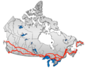 British Columbia: Highway 1 • Highway 5 • Highway 16 | Alberta: Highway 1 • Highway 16
Saskatchewan: Highway 1 • Highway 16 | Manitoba: Highway 1 • Highway 16 • Highway 100
Ontario: Highway 17 • Highway 69 • Highway 400 • Highway 12 • Highway 7 • Highway 71 • Highway 11 • Highway 66 • Highway 417
Quebec: Autoroute 40 • Autoroute 25 • Autoroute 20 • Autoroute 85 • Route 185 • Route 117 • Autoroute 15
New Brunswick: Route 2 • Route 16 | Confederation Bridge | Prince Edward Island: Route 1 | Nova Scotia: Highway 104 • Highway 105 • Highway 106
Newfoundland: Route 1The King's Highways of Ontario Current highwaysFormer highways- 2A
- 2B
- 2S
- 3B
- 4A
- 5A
- 7B
- 8A
- 12B
- 14
- 15A
- 18
- 18A
- 22
- 24A
- 25
- 27
- 29
- 30
- 31
- 32
- 35A
- 35B
- 36
- 38
- 39
- 40B
- 42
- 43
- 44
- 45
- 46
- 47
- 48B
- 50
- 51
- 52
- 53
- 54
- 55
- 56
- 57
- 59
- 68
- 70
- 73
- 74
- 75
- 76
- 78
- 79
- 80
- 81
- 82
- 83
- 84
- 86
- 87
- 88
- 90
- 91
- 92
- 95
- 96
- 97
- 98
- 99
- 100
- 103
- 104
- 106
- 107
- 109
- 110
- 111
- 114
- 116
- 117
- 119
- 120
- 121
- 122
- 123
- 126
- 128
- 131
- 133
- 134
- 135
- 136
- 169
- 400A
- 401A
County roads in Ontario · Ontario numbered highways · Expressways and 400-series highways · King's Highways · Secondary highways · Tertiary and 7000-series highways · List of Ontario provincial highways · List of former provincial highways in Ontario · Highways in Ontario · List of Ontario expressways · Trans-Canada Highway · Connecting Link · Emergency Detour RouteCategories:- Ontario provincial highways
- Trans-Canada Highway
- Lake Superior Circle Tour


Wikimedia Foundation. 2010.