- Lake Superior Provincial Park
Infobox Protected area
name = Lake Superior Provincial Park
iucn_category = II
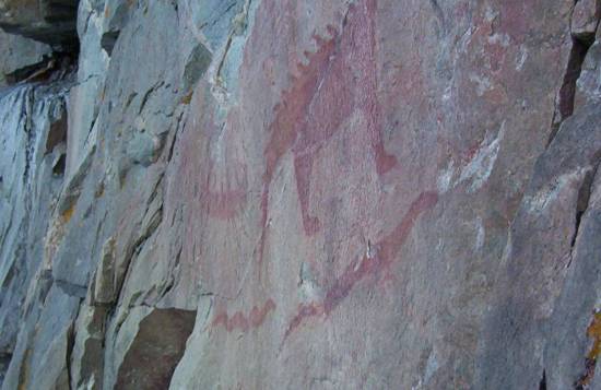
caption =Pictograph s at Agawa Rock
base_width = 300
locator_x =
locator_y =
location = Central Ontario
nearest_city =Wawa, Ontario
lat_degrees=47 |lat_minutes=45 |lat_seconds= |lat_direction=N
long_degrees=84 |long_minutes=50 |long_seconds= |long_direction=W
area =convert|155646|ha|acre|abbr=on|lk=on
established = 1944
visitation_num =
visitation_year =
governing_body =Ontario Parks
world_heritage_site =Lake Superior Provincial Park is one of the largest
provincial park s inOntario , covering about convert|1550|km2|sqmi along the northeastern shores ofLake Superior between Wawa and Sault Ste. Marie,Ontario ,Canada . TheTrans-Canada Highway now runs through the park, but when the park was originally established in 1944, there was no road access.Ecology
The rugged
Canadian Shield of the park is wooded with a mix ofconiferous anddeciduous trees such aspine ,maple s andbirch .Sugar maple dominates many forests in the southern two-thirds of the park. The predominantly rocky coastline is interrupted by sandy beaches in a few locations. The park supports a largemoose population. Other large animals found in the park include:
*White-tailed deer
* Woodland caribou ("Rangifer tarandus caribou")
* Black bear
*Grey wolf During the summer months, the park provides habitat for warblers and other birds of the northern forests.A number of rivers flow from the park's interior:
*Agawa River
*Baldhead River
* Coldwater River
*Gargantua River
* Old Woman River
* Red Rock River
* Sand RiverSeveralwaterfall s on these rivers can be seen from the road or reached viahiking trails.History
Traces of ancient
volcanic activity can be seen in rock outcrops near Red Rock Lake and several other sites. At Agawa Rock, near the mouth of theAgawa River , are pictographs created by the original inhabitants of this region. The figures painted on the rock withred ochre record both historical events and legendary figures. The first written description of these pictographs appears in a work byHenry Schoolcraft in 1851.Activities
Recreational activities in the park include
canoe ing,camping and hiking. A section of theVoyageur Trail follows the lake's shore through the park.Facilities
Campgrounds are located at:
* Agawa Bay
* Crescent Lake
* Rabbit Blanket LakeExternal links
* [http://www.ontarioparks.com/english/lakes.html Official Park Website]
* [http://www.lakesuperiorpark.ca/ Friends of Lake Superior Park]
Wikimedia Foundation. 2010.