Old Woman River (Ontario)
- Old Woman River (Ontario)
-
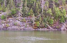
The Old Woman River is a river in the Algoma District of Ontario, Canada which empties into Old Woman Bay on Lake Superior south of Wawa, Ontario. It flows through Lake Superior Provincial Park.
The river follows a fault which became a spillway for glacial meltwater following the last ice age.
Towering cliffs along the bay have been home to peregrine falcons.
The name for the bay and river come from a rock formation near the river's mouth that resembles the face of an old woman.
See also
Categories: - Geography of Algoma District, Ontario
- Rivers of Ontario
- Tributaries of Lake Superior
- Northern Ontario geography stubs
Wikimedia Foundation.
2010.
Look at other dictionaries:
Old Woman's River, Ontario — Old Woman s River Community … Wikipedia
Liste der Flüsse in Ontario — Flüsse nach Provinz und Territorium BC AB SK … Deutsch Wikipedia
List of Ontario rivers — This is the list of rivers which are situated in and flow through Ontario. The watershed list includes tributaries as well.List of rivers arranged by watershedHudson Bay watershedIn order of drainage into Hudson Bay from west to east: *Echoing… … Wikipedia
Ontario — Ontarian, Ontaric /on tar ik/, adj., n. /on tair ee oh /, n. 1. a province in S Canada, bordering on the Great Lakes. 8,131,618; 412,582 sq. mi. (1,068,585 sq. km). Cap.: Toronto. 2. Lake, a lake between the NE United States and S Canada, between … Universalium
Old Dutch Church (Kingston, New York) — First Reformed Protestant Dutch Church of Kingston Church spire and south elevation, 2008 Basic information Location Kingston, NY, USA Geographic coordinates … Wikipedia
List of communities in Ontario — Communities in the province of Ontario, Canada Note: this is an incomplete list of communities, not necessarily organized municipalities. For organized municipalities see list of municipalities in Ontario and for census subdivisions see list of… … Wikipedia
Mississippi River — For the river in Canada, see Mississippi River (Ontario). Coordinates: 29°09′04″N 89°15′12″W / 29.15111°N 89.25333°W / … Wikipedia
Mindemoya River — The Mindemoya River is a river on Manitoulin Island in Ontario, Canada which flows about 5 kilometres (3.1 mi) from Lake Mindemoya to empty into Providence Bay on Lake Huron. There is a large sandy beach at the mouth of the river. Mindemoya… … Wikipedia
New York, Ontario and Western Railway — Reporting mark OW Locale North Jersey, Upstate New York and Northeastern Pennsylvania Dates of operation 1884– … Wikipedia
Grand River land dispute — Aboriginal peoples in Canada … Wikipedia
 Old Woman River
