- Ottawa River
-
This article is about the river in Canada. For other uses, see Ottawa River (disambiguation).
Ottawa River (Kichisìpi) Rivière des Outaouais 
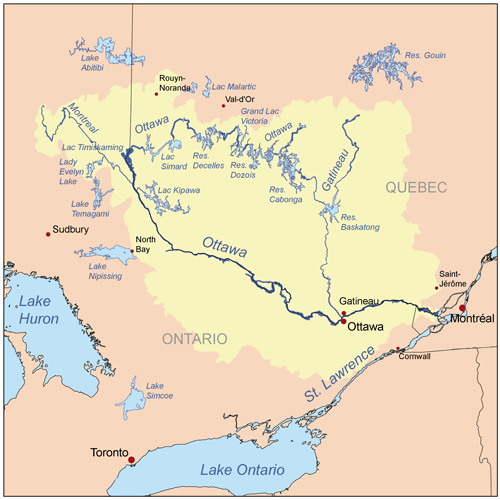
Country Canada Provinces Quebec, Ontario Source Lake Capimitchigama - location Lac-Moselle, La Vallée-de-la-Gatineau RCM, Outaouais, Quebec - coordinates 47°36′N 75°48′W / 47.6°N 75.8°W Mouth St. Lawrence River - location Montreal, Quebec - coordinates 45°27′N 74°05′W / 45.45°N 74.083°W Length 1,271 km (790 mi) Basin 146,300 km2 (56,487 sq mi) Discharge for Carillon dam - average 1,950 m3/s (68,864 cu ft/s) - max 5,351 m3/s (188,969 cu ft/s) - min 749 m3/s (26,451 cu ft/s)  Map of the Ottawa River drainage basin
The Ottawa River (French: Rivière des Outaouais) is a river in the Canadian provinces of Ontario and Quebec. For most of its length, it now defines the border between these two provinces.
Contents
Geography
The river rises from its source in Lake Capimitchigama, in the Laurentian Mountains of central Quebec, and flows west to Lake Timiskaming. From there its route has been used to define the interprovincial border with Ontario.
From Lake Timiskaming, the river flows southeast to Ottawa and Gatineau, where it tumbles over the Chaudière Falls and further takes in the Rideau and Gatineau rivers.
The Ottawa River drains into the Lake of Two Mountains and the St. Lawrence River at Montreal. The total length of the river is 1,271 kilometers (790 mi); it drains an area of 146,300 km2, 65% in Quebec and the rest in Ontario, with a mean discharge of 1,950 m3/s.[1]
The average annual mean waterflow measured at Carillon dam, near the Lake of Two Mountains, is 1,939 m3/s, with average annual extremes of 749 to 5,351 m3/s. Record historic levels since 1964 are a low of 529 in 2005 and a high of 8190 m3/s in 1976.[2]
Major tributaries include:
- Bonnechere River
- Coulonge River
- Dumoine River
- Gatineau River
- Kipawa River
- du Lièvre River
- Madawaska River
- Mattawa River
- Mississippi River
- Montreal River
- Rivière du Nord
- Noire River
- Petawawa River
- Rideau River
- Rouge River
- South Nation River
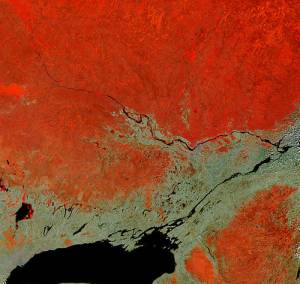
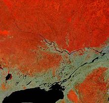 In this false-colour satellite image, the Ottawa River flows southeast, joining the St. Lawrence River which flows northeast. Heavily forested areas appear differing shades of orange/red, while farmland is tan shades.
communities along the Ottawa River include (in down-stream order):
Geology
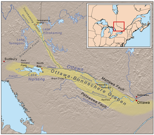 Map of the Ottawa-Bonnechere Graben
The Ottawa River lies in the Ottawa-Bonnechere Graben, which is a Mesozoic rift valley that formed 175 million years ago. Following the retreat of the glaciers from the area at the end of the last ice age, the valley was flooded by an arm of the Atlantic Ocean known as the Champlain Sea. Fossil remains of marine life have been found in marine clay formed during that time. Sediment deposits from this period have resulted in areas of poor drainage and the presence of large bogs in some ancient channels of this river. Another consequence was the formations of large deposits of a material commonly known as Leda clay; these deposits become highly unstable after heavy rains. Numerous landslides have occurred as a result. The former site of the town of Lemieux, Ontario collapsed into the South Nation River in 1993; however, the residents had already been relocated because of the suspected instability of the earth in that location.
Large numbers of Canada Geese, ducks, gulls and shorebirds take advantage of spring flooding and wetlands in the Ottawa River valley during migration. Ducks also overwinter in sections of the river that do not freeze over.
History
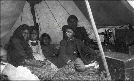
See also: Ottawa River timber trade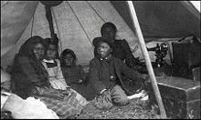 An Algonquin Family
As it does to this day, the river played a vital role in life of the Algonquin people, who lived throughout its watershed at contact. The river is called Kichisìpi, meaning "Great River" in Anicinàbemowin, the Algonquin language. The Algonquin define themselves in terms of their position on the river, referring to themselves as the Omàmiwinini, 'down-river people'. Although a majority of the Algonquin First Nation lives in Quebec, the entire Ottawa Valley is Algonquin traditional territory. Present settlement is a result of adaptations made as a result of settler pressures.[3]
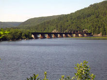 A railway bridge over the Ottawa River in Mattawa, Ontario.
Some early European explorers, possibly considering the Ottawa River to be more significant than the Upper St. Lawrence River, applied the name River Canada to the Ottawa River and the St. Lawrence River below the confluence at Montreal. As the extent of the Great Lakes became clear and the river began to be regarded as a tributary, it was variously known as the Grand River, "Great River" or Grand River of the Algonquins before the present name was settled upon. This name change resulted from the Ottawa peoples' control of the river circa 1685. However, only one band of Ottawa, the Kinouncherpirini or Keinouch, ever inhabited the Ottawa Valley.
In 1615, Samuel de Champlain and Étienne Brûlé, assisted by Algonquin guides, were the first Europeans to travel up the Ottawa River and follow the water route west along the Mattawa and French Rivers to the Great Lakes. See Canadian Canoe Routes (early). For the following two centuries, this route was used by French fur traders, Voyageurs and Coureur des bois to Canada's interior. The river posed serious hazards to these travelers. The section near Deux Rivières used to have spectacular and wild rapids, namely the Rapide de la Veillée, the Trou, the Rapide des Deux Rivières, and the Rapide de la Roche Capitaine. In 1800, explorer Daniel Harmon reported 14 crosses marking the deaths of voyageurs who had drowned in the dangerous waters along this section of the Ottawa.[4]
In the early 19th century, the Ottawa River and its tributaries were used to gain access to large virgin forests of white pine. A booming trade in timber developed, and large rafts of logs were floated down the river. A scattering of small subsistence farming communities developed along the shores of the river to provide manpower for the lumber camps in winter. In 1832, following the War of 1812, the Ottawa River gained strategic importance when the Carillon Canal was completed. Together with the Rideau Canal, the Carillon Canal was constructed to provide an alternate military supply route to Kingston and Lake Ontario, bypassing the route along the Saint Lawrence River.[5]
Power generation
A pulp and paper mill (at Témiscaming) and several hydroelectric dams have been constructed on the river. In 1950, the dam at Rapides-des-Joachims, was built, forming Holden Lake behind it and thereby submerging the rapids and portages at Deux Rivières.[4] As an economic route, its importance was eclipsed by railroad and highways in the 20th century. It is no longer used for log driving, however, it is still extensively used for recreational boating. Some 20,000 pleasure boaters visit the Carillon Canal annually.[5]
Today, Outaouais Herald Emeritus at the Canadian Heraldic Authority is named after the river.
Hydroelectric installations
Hydroelectric installations on the Upper Ottawa (in downstream order):
Installation Type Generating cap. Year built Name of reservoir Operator Bourque Dam Dam n/a 1949 Dozois Reservoir Hydro-Québec Rapide-7 Generating station 48 MW 1941 / 1949 Decelles Lake Hydro-Québec Rapide-2 Run of river g.s. 48 MW 1954 n/a Hydro-Québec Rapides-des-Quinze Run of river g.s. 95 MW 1923 n/a Hydro-Québec Rapides-des-îles Run of river g.s. 147 MW 1966 n/a Hydro-Québec Première-Chute Run of river g.s. 130 MW 1968 n/a Hydro-Québec Lower Ottawa (in downstream order):
Installation Type Generating cap. Year built Name of reservoir Operator Otto Holden Run of river g.s. 243 MW 1952 n/a Ontario Power Generation Des Joachims Run of river g.s. 429 MW 1950 Holden Lake Ontario Power Generation Bryson Run of river g.s. 61 MW 1925 n/a Hydro-Québec Chenaux Run of river g.s. 144 MW 1950 n/a Ontario Power Generation Chute-des-Chats (Chats Falls) Run of river g.s. 185 MW 1931 Lac des Chats Hydro-Québec and OPG * Hull-2 Run of river g.s. 27 MW 1920 n/a Hydro-Québec Carillon Run of river g.s. 752 MW 1962 n/a Hydro-Québec * Ontario Power Generation operates generators 2, 3, 4, and 5 with a capacity of 96 MW; and Hydro-Québec operates generators 6, 7, 8, and 9 with a capacity of 89 MW.
See also
- Lake of Two Mountains
- List of Ontario rivers
- List of crossings of the Ottawa River
- List of islands of Ontario#Ottawa_River
- List of longest rivers of Canada
- Southern Ontario
- Eastern Ontario
- List of Quebec rivers
- Rivière des Mille Îles
- Rivière des Prairies
- Quebec
References
- ^ "Facts about Canada: Rivers". Natural Resources Canada/Atlas of Canada. http://atlas.nrcan.gc.ca/site/english/learningresources/facts/rivers.html. Retrieved 2008-02-24.
- ^ "Historical Water Levels Summary, Ottawa River at Carillon". Ottawa River Regulation Planning Board. http://www.ottawariver.ca/carillon.htm. Retrieved 2008-02-24.
- ^ "Algonquin Land Claim with Ontario". Ontario Ministry of Aboriginal Affairs. http://www.aboriginalaffairs.gov.on.ca/english/negotiate/algonquin/algonquin.asp. Retrieved 2009-06-30.
- ^ a b Ontario Heritage Foundation, Ministry of Culture and Communications
- ^ a b "Carillon Canal National Historic Site of Canada, Cultural Heritage". Parks Canada. http://www.pc.gc.ca/lhn-nhs/qc/canalcarillon/natcul/natcul2_E.asp. Retrieved 2009-02-09.
External links
- Ottawa-Gatineau Watershed Atlas (OGWA)
- Ottawa River Regulation Planning Board
- Ottawa Riverkeeper
- The Ottawa River
- Algonkin History
Categories:- Geography of Ottawa
- Rivers of Ontario
- Rivers of Quebec
- Geography of Gatineau
- Borders of Quebec
- Borders of Ontario
- Geography of Montérégie


Wikimedia Foundation. 2010.