- Vaudreuil-Dorion
-
Vaudreuil-Dorion — City — Ville de Vaudreuil-Dorion Location within Vaudreuil-Soulanges Regional County Municipality. Coordinates (2555, rue Dutrisac [1]): 45°24′16″N 74°02′08″W / 45.40444°N 74.03556°W Country  Canada
Province  Quebec
Region Montérégie (16) RCM Vaudreuil-Soulanges Incorporated March 16, 1994 Electoral Districts
Federal
Vaudreuil-SoulangesProvincial Vaudreuil Government[1][2][3] – Mayor Guy Pilon – Federal MP(s) Jamie Nicholls (NDP) – Quebec MNA(s) Yvon Marcoux (PLQ) Area[4] – Land 72.50 km2 (28 sq mi) Population (2006)[4] – Total 27,330 – Density 355.7/km2 (921.3/sq mi) – Change (2001-06)  29.5%
29.5%– Dwellings 10,637 Time zone EST (UTC-5) – Summer (DST) EDT (UTC-4) Postal code(s) J7T to J7V Area code(s) 450 Access Routes[5]
 A-20
A-20
 A-40
A-40
 A-540
A-540
 Route 338
 Route 340
 Route 342
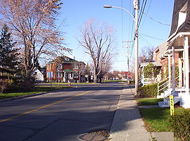
Website www.ville.vaudreuil-dorion.qc.ca Vaudreuil-Dorion is an off-island suburb of Montreal, in southwestern Quebec in the Vaudreuil-Soulanges Regional County Municipality. The result of the merger of two towns, Vaudreuil and Dorion, the municipality's population as of 2009 is estimated to be approximately 27,330.
Vaudreuil-Dorion is currently experiencing high population growth as farmland is converted to residential areas and commercial developments.
Contents
History
On 23 November 1702, governor of New France Louis-Hector de Callière gave a seigneury to Philippe de Vaudreuil, who was governor of Montreal at the time. Rigaud de Vaudreuil will later become governor of New France.
In 1725, the region had only 38 inhabitants. It was only about 1742, when people began to be interested in the region, that Vaudreuil's population rose. There were 381 people living in Vaudreuil in 1765. It is with the creation of the Grand Trunk Railway that people began to live in Dorion, which was called Vaudreuil Station. Dorion became a village in 1891.
Dorion was bisected by Autoroute 20 which links Downtown Montreal and Toronto as well as Highway 401 in Ontario. The CN and CP rail links between Toronto and Montreal are located in Dorion. Housing developments began in the 1950s and continued well into the 1970s. Throughout the 1980s and the 1990s, housing began sprouting north and east of Dorion.
Vaudreuil and Dorion merged in 1994, becoming the current city of "Vaudreuil-Dorion".
Geography
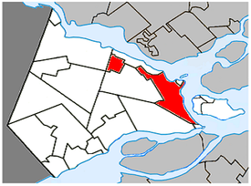
Vaudreuil-Dorion is located on the south shores of the Lake of Two Mountains at the confluence of the Saint Lawrence and Ottawa Rivers, just off the western edge of Île Perrot. The city consists of two non-contiguous parts: its eastern part is the larger main area along Lake of Two Mountains where the population centres of Vaudreuil and Dorion are located; the western portion is a smaller, more rural area that borders Rigaud.
Demographics
Population
Population trend[6]
Census Population Change (%) 2009 27,330  10.6%
10.6%2006 25,789  29.5%
29.5%2001 19,920  7.9%
7.9%1996 18,466  7.9%
7.9%1991 17,109* N/A (1991* = combined figure for former towns)
Language
Mother tongue language (2006)[4]
Language Population Pct (%) French only 18,630 73.36% English only 4,160 16.38% Both English and French 285 1.12% Other languages 2,325 9.16% Infrastructure
Transportation
The city is the point of intersection for two of Canada's busiest highways: Autoroute 40/Autoroute 540/Autoroute 20 (connecting the Quebec City-Windsor Corridor) and the Trans-Canada Highway.
Local bus service is operated by CIT La Presqu'Île connecting to the Vaudreuil-Hudson commuter rail line.
Media
CJVD-FM operates studios in Vaudreuil-Dorion, broadcasting at 100.1 FM in the Vaudreuil-Soulanges, West of Montreal-Island (West-Island) and Valleyfield areas. On the air since September 2008, CJVD-FM airs a French and English hits format from 1970 to 1995, as well as the Sixties. It is also available on the Internet at CJVD.CA
Education
[7]
Sainte-Madelaine Elementary school was founded in 1960. It is located on Sainte-Madelaine street and has undergone substantial changes in 1991 through 1993 then again in 1997 through 1998. Furthermore, in 2005, the day care centre was enlarged to satisfy the growing demands of the school population. The school currently hosts elementary students for grades 3, 4, 5 and 6. There are 560 students attending the establishment.
École St-Michel
École Harwood
École Marguerite-Bourgeoys
École du Papillon-Bleu
École Secondaire Vaudreuil
See also
References
- ^ a b Ministère des Affaires Municipales et Régions: Vaudreuil-Dorion
- ^ Parliament of Canada Federal Riding History: VAUDREUIL--SOULANGES (Quebec)
- ^ Chief Electoral Officer of Québec - 40th General Election Riding Results: VAUDREUIL
- ^ a b c 2006 Statistics Canada Community Profile: Vaudreuil-Dorion, Quebec
- ^ Official Transport Quebec Road Map
- ^ Statistics Canada: 1996, 2001, 2006 census
- ^ École Sainte-Madelaine
External links
- (French) Ville de Vaudreuil-Dorion
- http://www.adbvd.com - Vaudreuil Basesball Association
- Surrounding area - Hudson, Quebec
Eastern part:
Hudson Vaudreuil-sur-le-Lac / L'Île-Cadieux 
Saint-Lazare 
Lake of Two Mountains bridges to
Senneville / Pincourt / Terrasse-Vaudreuil Vaudreuil-Dorion

Les Cèdres Pointe-des-Cascades Western part:
Hudson 
Rigaud 
Saint-Lazare  Vaudreuil-Dorion

Saint-Lazare  Administrative divisions of Montérégie (Region 16)
Regional county municipalities
and equivalent territoriesBrome-Missisquoi · La Haute-Yamaska · Acton · Pierre-De Saurel · Les Maskoutains · Rouville · Le Haut-Richelieu · La Vallée-du-Richelieu · Longueuil · Marguerite-d'Youville · Roussillon · Les Jardins-de-Napierville · Le Haut-Saint-Laurent · Beauharnois-Salaberry · Vaudreuil-Soulanges
Municipalities Cowansville · Granby · Sorel-Tracy · Saint-Hyacinthe · Saint-Jean-sur-Richelieu · Chambly · Saint-Basile-le-Grand · Mont-Saint-Hilaire · Belœil · Brossard · Saint-Lambert · Boucherville · Saint-Bruno-de-Montarville · Longueuil · Sainte-Julie · Varennes · La Prairie · Candiac · Sainte-Catherine · Saint-Constant · Mercier · Châteauguay · Beauharnois · Salaberry-de-Valleyfield · Pincourt · Vaudreuil-Dorion · Saint-Lazare
Categories:- Vaudreuil-Dorion
- Quebec communities with significant anglophone populations
Wikimedia Foundation. 2010.


