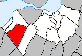
- Mercier, Quebec
-
This article is about the South Shore suburb of Montreal. For the former East Island of Montreal federal riding, see Mercier (electoral district). For the current East Island of Montreal federal riding, see Honoré-Mercier (electoral district). For the Plateau Mont-Royal provincial riding, see Mercier (provincial electoral district). For the borough of Montreal, see Mercier–Hochelaga-Maisonneuve.For the Quebec bridge, see Honoré Mercier Bridge.Not to be confused with the former Montreal district, and former municipality, Mercier, Montreal
Mercier, Quebec — Ville — Location within Roussillon Regional County Municipality. Coordinates (869, boulevard Saint-Jean-Baptiste [1]): 45°18′42″N 73°44′42″W / 45.31167°N 73.745°W Country  Canada
Province  Quebec
Region Montérégie RCM Roussillon Established July 01, 1855 Incorporated June 08, 1964 Electoral Districts
Federal
Châteauguay—Saint-ConstantProvincial Châteauguay Government[1][2][3] - Mayor Jacques Lambert - Federal MP(s) Carole Freeman (BQ) - Quebec MNA(s) Pierre Moreau (PLQ) Area[4] - Total 45.95 km2 (17.7 sq mi) Population (2006)[4] - Total 10,121 - Density 220.3/km2 (570.6/sq mi) - Change (2001-06)  7.2%
7.2%- Dwellings 3,733 Time zone EST (UTC-5) - Summer (DST) EDT (UTC-4) Postal code(s) J6R Area code(s) 450 Access Routes[5]  Route 138
Website www.ville.mercier.qc.ca Mercier is a town in southwestern Quebec, Canada in the Regional County Municipality Roussillon. It is located on the Châteauguay River, southwest of Montreal. The population as of the Canada 2006 Census was 10,121.
Contents
Demographics
Population
Population trend[6]
Census Population Change (%) 2006 10,121  7.2%
7.2%2001 9,442  4.2%
4.2%1996 9,059  10.1%
10.1%1991 8,227 N/A Language
Mother tongue language (2006)[4]
Language Population Pct (%) French only 9,210 91.19% English only 555 5.49% Both English and French 45 0.45% Other languages 290 2.87% Infrastructure
Transportation
The CIT du Haut-Saint-Laurent provides commuter and local bus services.
See also
References
- ^ a b Ministère des Affaires Municipales et Régions: Mercier
- ^ Parliament of Canada Federal Riding History: CHÂTEAUGUAY--SAINT-CONSTANT, Quebec
- ^ Chief Electoral Officer of Québec - 40th General Election Results: CHÂTEAUGUAY
- ^ a b c 2006 Statistics Canada Community Profile: Mercier, Quebec
- ^ Official Transport Quebec Road Map
- ^ Statistics Canada: 1996, 2001, 2006 census
External links

Châteauguay 
Sainte-Martine 
Saint-Isidore  Mercier

Saint-Urbain-Premier  Administrative divisions of Montérégie (Region 16)
Regional county municipalities
and equivalent territoriesBrome-Missisquoi · La Haute-Yamaska · Acton · Pierre-De Saurel · Les Maskoutains · Rouville · Le Haut-Richelieu · La Vallée-du-Richelieu · Longueuil · Lajemmerais · Roussillon · Les Jardins-de-Napierville · Le Haut-Saint-Laurent · Beauharnois-Salaberry · Vaudreuil-Soulanges
Municipalities Cowansville · Granby · Sorel-Tracy · Saint-Hyacinthe · Saint-Jean-sur-Richelieu · Chambly · Saint-Basile-le-Grand · Mont-Saint-Hilaire · Belœil · Brossard · Saint-Lambert · Boucherville · Saint-Bruno-de-Montarville · Longueuil · Sainte-Julie · Varennes · La Prairie · Candiac · Sainte-Catherine · Saint-Constant · Mercier · Châteauguay · Beauharnois · Salaberry-de-Valleyfield · Pincourt · Vaudreuil-Dorion · Saint-Lazare
Administrative divisions of Quebec Coordinates: 45°21′N 73°48′W / 45.35°N 73.8°W
Categories:- Cities and towns in Quebec
- Incorporated places in Montérégie
- Greater Montreal
- Montérégie geography stubs
Wikimedia Foundation. 2010.

