- Coteau-du-Lac, Quebec
-
Coteau-du-Lac, Quebec — Town — 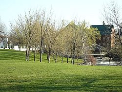 Location within Vaudreuil-Soulanges Regional County Municipality.
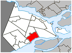
Coordinates (20, Chemin Rivière Delisle [1]): 45°18′03″N 74°10′58″W / 45.30083°N 74.18278°W Country  Canada
Province  Quebec
Region Montérégie RCM Vaudreuil-Soulanges Constitution February 06, 1982 Electoral Districts
Federal
Vaudreuil-SoulangesProvincial Soulanges Government[1][2][3] – Mayor Robert Sauvé – Federal MP(s) Jamie Nicholls (NDP) – Quebec MNA(s) Lucie Charlebois (PLQ) Area[4] – Land 47.06 km2 (18.2 sq mi) Population (2006)[4] – Total 6,346 – Density 134.9/km2 (349.4/sq mi) – Change (2001-06)  13.9%
13.9%– Dwellings 2,407 Time zone EST (UTC-5) – Summer (DST) EDT (UTC-4) Postal code(s) J0P Area code(s) 450 Access Routes[5]
 A-20
A-20
 Route 201
 Route 338
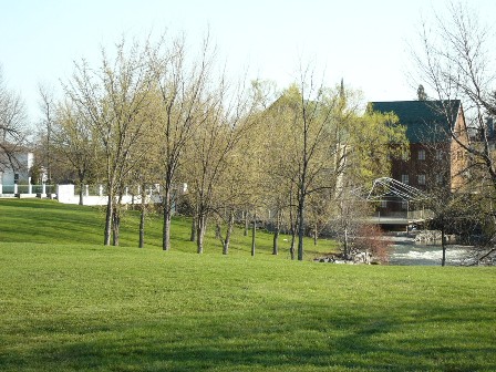
Website www.coteau-du-lac.com Coteau-du-Lac is a small town in southwestern Quebec, Canada. It is on the north shore of the St. Lawrence River in the Vaudreuil-Soulanges Regional County Municipality.
The name of the town comes from the old French word Coteau which meant "cluster of homes" and from its location on the north shore of Lake Saint Francis.[6] The National historic site of the Coteau-du-Lac canal is the location of the first canal lock system in North America. The city has an industrial park.
As of the 2001 census, the town had a total population of 5,573, but the city estimates the current population to be above 6,500.[7]
Contents
Demographics
Population
Population trend[8]
Census Population Change (%) 2006 6,346 13.9%2001 5,573 12.4%1996 4,960 18.3%1991 4,193 N/A Language
Mother tongue language (2006)[4]
Language Population Pct (%) French only 5,960 95.59% English only 140 2.25% Both English and French 45 0.72% Other languages 90 1.44% References
- ^ a b Ministère des Affaires Municipales et Regions Quebec: Coteau-du-Lac
- ^ Parliament of Canada Federal Riding History: VAUDREUIL--SOULANGES (Quebec)
- ^ Chief Electoral Officer of Québec - 40th General Election Riding Results: SOULANGES
- ^ a b c 2006 Statistics Canada Community Profile: Coteau-du-Lac, Quebec
- ^ Official Transport Quebec Road Map
- ^ Parks Canada Website
- ^ Coteau-du-Lac Official Website
- ^ Statistics Canada: 1996, 2001, 2006 census
External links
 Media related to Coteau-du-Lac (Québec) at Wikimedia Commons
- Official website (French)

Saint-Polycarpe Saint-Clet Les Coteaux 
Les Cèdres  Coteau-du-Lac

Saint Lawrence River
Bridge to Salaberry-de-Valleyfield Administrative divisions of Montérégie (Region 16)Regional county municipalities
and equivalent territoriesBrome-Missisquoi · La Haute-Yamaska · Acton · Pierre-De Saurel · Les Maskoutains · Rouville · Le Haut-Richelieu · La Vallée-du-Richelieu · Longueuil · Marguerite-d'Youville · Roussillon · Les Jardins-de-Napierville · Le Haut-Saint-Laurent · Beauharnois-Salaberry · Vaudreuil-Soulanges
Municipalities Cowansville · Granby · Sorel-Tracy · Saint-Hyacinthe · Saint-Jean-sur-Richelieu · Chambly · Saint-Basile-le-Grand · Mont-Saint-Hilaire · Belœil · Brossard · Saint-Lambert · Boucherville · Saint-Bruno-de-Montarville · Longueuil · Sainte-Julie · Varennes · La Prairie · Candiac · Sainte-Catherine · Saint-Constant · Mercier · Châteauguay · Beauharnois · Salaberry-de-Valleyfield · Pincourt · Vaudreuil-Dorion · Saint-Lazare
Coordinates: 45°18′N 74°11′W / 45.3°N 74.183°W
Categories:- Municipalities in Quebec
- Populated places on the Saint Lawrence River
- Incorporated places in Montérégie
- Montérégie geography stubs

Wikimedia Foundation. 2010.