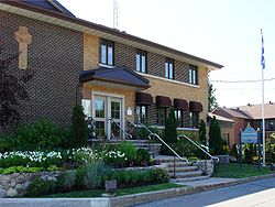
- Notre-Dame-de-l'Île-Perrot, Quebec
-
Notre-Dame-de-l'Île-Perrot — Ville — Town hall Location within Vaudreuil-Soulanges Regional County Municipality. Coordinates (21, rue de l'Église [1]): 45°21′01″N 73°54′09″W / 45.35028°N 73.9025°W Country  Canada
Province  Quebec
Region Montérégie RCM Vaudreuil-Soulanges Incorporated April 14, 1984 Electoral Districts
Federal
Vaudreuil-SoulangesProvincial Vaudreuil Government[1][2][3] – Mayor Marie-Claude Nichols – Federal MP(s) Meili Faille (BQ) – Quebec MNA(s) Yvon Marcoux (PLQ) Area[4] – Land 27.80 km2 (10.7 sq mi) Population (2006)[4] – Total 9,885 – Density 355.6/km2 (921/sq mi) – Change (2001-06)  15.7%
15.7%– Dwellings 3,459 Time zone EST (UTC-5) – Summer (DST) EDT (UTC-4) Postal code(s) J7V Area code(s) 514, 438 Website www.ndip.org Notre-Dame-de-l'Île-Perrot is the largest of four municipalities located on Île Perrot, west of the island of Montreal, Quebec. The population as of the Canada 2006 Census was 9,885.
Contents
Demographics
Population
Population trend[5]
Census Population Change (%) 2006 9,885  15.7%
15.7%2001 8,546  21.1%
21.1%1996 7,059  34.2%
34.2%1991 5,261 N/A Language
Mother tongue language (2006)[4]
Language Population Pct (%) French only 7,035 71.31% English only 1,980 20.07% Both English and French 150 1.52% Other languages 700 7.10% Infrastructure
Transportation
There is a shuttle bus service operated by CIT La Presqu'Île connecting to the Dorion-Rigaud commuter rail line.
See also
References
- ^ a b Ministère des Affaires Municipales et Régions: Notre-Dame-de-l'Île-Perrot
- ^ Parliament of Canada Federal Riding History: VAUDREUIL-SOULANGES (Quebec)
- ^ Chief Electoral Officer of Québec - 40th General Election Riding Results: VAUDREUIL
- ^ a b c 2006 Statistics Canada Community Profile: Notre-Dame-de-l'Île-Perrot, Quebec
- ^ Statistics Canada: 1996, 2001, 2006 census

L'Île-Perrot 
Pincourt 
Lac Saint-Louis  Notre-Dame-de-l'Île-Perrot

Lac Saint-Louis  Administrative divisions of Montérégie (Region 16)
Regional county municipalities
and equivalent territoriesBrome-Missisquoi · La Haute-Yamaska · Acton · Pierre-De Saurel · Les Maskoutains · Rouville · Le Haut-Richelieu · La Vallée-du-Richelieu · Longueuil · Marguerite-d'Youville · Roussillon · Les Jardins-de-Napierville · Le Haut-Saint-Laurent · Beauharnois-Salaberry · Vaudreuil-Soulanges
Municipalities Cowansville · Granby · Sorel-Tracy · Saint-Hyacinthe · Saint-Jean-sur-Richelieu · Chambly · Saint-Basile-le-Grand · Mont-Saint-Hilaire · Belœil · Brossard · Saint-Lambert · Boucherville · Saint-Bruno-de-Montarville · Longueuil · Sainte-Julie · Varennes · La Prairie · Candiac · Sainte-Catherine · Saint-Constant · Mercier · Châteauguay · Beauharnois · Salaberry-de-Valleyfield · Pincourt · Vaudreuil-Dorion · Saint-Lazare
Coordinates: 45°22′N 73°56′W / 45.367°N 73.933°W
Categories:- Cities and towns in Quebec
- Incorporated places in Montérégie
- Quebec communities with significant anglophone populations
- Greater Montreal
- Montérégie geography stubs
Wikimedia Foundation. 2010.


