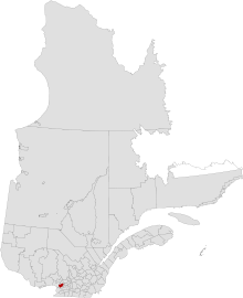
- Mirabel, Quebec
-
Mirabel — City — City of Mirabel - Ville de Mirabel Coordinates: 45°39′N 74°05′W / 45.65°N 74.083°W Country Canada Province Quebec Region Laurentides Settled Incorporated January 1, 1971 Government - Type Ville - Mayor Hubert Meilleur - Federal riding Argenteuil—Papineau—Mirabel - Prov. riding Mirabel Area[1] - Land 485.51 km2 (187.5 sq mi) Population (2006)[1] - Total 34,626 - Density 71.3/km2 (184.7/sq mi) Time zone EST (UTC-5) - Summer (DST) EDT (UTC-4) Postal Code J7J, J7N Area code(s) 450 Website www.ville.mirabel.qc.ca Mirabel is a city in Quebec, Canada. It is an off-island suburb north-west of Montreal.
Mirabel is also the name of a territory equivalent to a regional county municipality (TE) and census division (CD) of Quebec, coextensive with the city of Mirabel.[1] Its geographical code is 74.
Mirabel's population was 34,626 in 2006. It is currently the fastest growing city in Canada with a grow rate of 26.8 in the 2006 census.[1] To compare, Calgary has a growing rate of 15%.
The city is home to Montréal-Mirabel International Airport.
A recreation and tourist project, named Lac-Mirabel, will be located in Mirabel. It will be an investment of $350 million and will create some 3200 jobs. The city will be served by commuter trains of the Blainville-Saint-Jerome Line of the Agence métropolitaine de transport. Commuter trains to Montreal started to serve the Saint-Jérôme station on Monday January 8, 2007, with four trains in each direction each business day.[2] However, the Mirabel train station has not yet opened, due to delays in rezoning agricultural land for use as a train station.
Contents
History
Mirabel was formed through the expropriation of private lands and the merger of 8 municipalities in 1971. The former municipalities were (with their individual founding dates in brackets): Saint-Augustin (1855); Saint-Benoît (1855); Saint-Hermas (1855); Saint-Janvier-de-Blainville (1855); Sainte-Scholastique (1855); Saint-Canut (1857); Sainte-Monique (1872), and Saint-Janvier-de-la-Croix (1959). Initially called Ville de Sainte-Scholastique and renamed to Mirabel in 1973, the city was planned to become a vast transportation and industrial hub for eastern Canada with Montréal-Mirabel International Airport at its centre.[3]
The airport, which opened in 1975, never became a major aviation hub and the industrial parks never materialized, and in 2004 the airport closed to all passenger traffic.
In 2000, about 10 square kilometers of Mirabel's territory was annexed by Lachute.
Communities
- La Belle-Rivière
- La Chapelle
- Mirabel-en-Haut
- Petit St-Charles
- Saint-Augustin
- Saint-Benoît
- Saint-Canut
- Sainte-Monique
- Saint-Hermas
- Saint-Janvier
- Sainte-Scholastique
Demographics
Population:[4]
- Population in 2006: 34,626
- 2001 to 2006 population change: 26.8 %
- Population in 2001: 27,330
- Population in 1996: 22,689 (or 22,626 when adjusted for current boundary)
- Population in 1991: 17,971
Total private dwellings, excluding seasonal cottages: 12,714 (total: 13,161)
Mother tongue:
- English as first language: 1.5 %
- French as first language: 96 %
- English and French as first language: 0.5 %
- Other as first language: 2 %
Sister cities
- Châlons-en-Champagne (France)
References
- ^ a b c d Statistics Canada 2006 Census
- ^ La Presse, Le mardi 28 novembre 2006 "Saint-Jérôme aura son train de banlieue" par Jean-Paul Charbonneau
- ^ "Mirabel (ville)" (in French). Commission de toponymie du Québec. http://www.toponymie.gouv.qc.ca/ct/topos/carto.asp?Speci=72473&Latitude=45,65&Longitude=-74,08334&Zoom=1700. Retrieved 2009-03-10.
- ^ Statistics Canada: 1996, 2001, 2006 census
External links

Saint-Colomban, Saint-Jérôme Sainte-Sophie
Sainte-Anne-des-Plaines
Lachute
Saint-André-d'Argenteuil
Blainville
Sainte-Thérèse Mirabel

Saint-Placide Oka, Kanesatake, Saint-Joseph-du-Lac, Saint-Eustache Boisbriand  Administrative divisions of Laurentides (Region 15)
Regional county municipalities
and equivalent territoriesDeux-Montagnes · Thérèse-de-Blainville · Mirabel · La Rivière-du-Nord · Argenteuil · Les Pays-d'En-Haut · Les Laurentides · Antoine-Labelle
Municipalities Saint-Eustache · Deux-Montagnes · Sainte-Marthe-sur-le-Lac · Pointe-Calumet · Boisbriand · Sainte-Thérèse · Blainville · Rosemère · Lorraine · Bois-des-Filion · Sainte-Anne-des-Plaines · Mirabel · Saint-Colomban · Saint-Jérôme · Sainte-Sophie · Prévost · Saint-Hippolyte · Lachute · Brownsburg-Chatham · Estérel · Sainte-Marguerite-du-Lac-Masson · Sainte-Adèle · Saint-Sauveur · Sainte-Agathe-des-Monts · Barkmere · Mont-Tremblant · Rivière-Rouge · Mont-Laurier
Administrative divisions of Quebec  Administrative divisions of Quebec
Subdivisions Communities Major cities Montreal · Quebec · Laval · Gatineau · Longueuil · Sherbrooke · Saguenay · Lévis · Trois-Rivières
Categories:- Cities and towns in Quebec
- Census divisions of Quebec
- Territories equivalent to a regional county municipality
- Incorporated places in Laurentides
- Greater Montreal
Wikimedia Foundation. 2010.

