- Gatineau
-
This article is about the Canadian city. For other uses, see Gatineau (disambiguation).
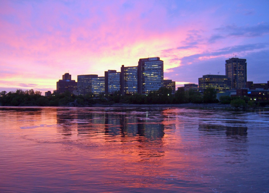
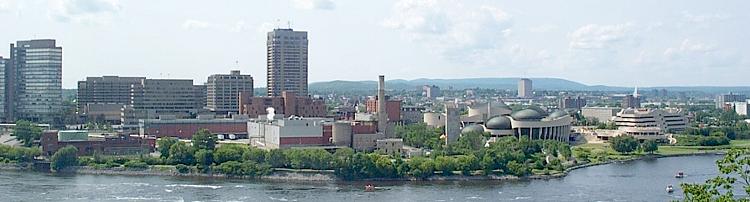
Gatineau — City — City of Gatineau - Ville de Gatineau The sun sets on office buildings in Hull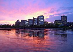
Coat of arms
LogoMotto: Fortunae meae, multorum faber[1] Location in Quebec, Canada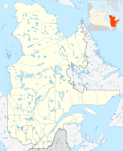
 Gatineau
Coordinates (25, rue Laurier): 45°25′40″N 75°42′38″W / 45.42778°N 75.71056°W Country  Canada
Province  Quebec
Administrative Region Outaouais Amalgamated 2002 Government – Mayor Marc Bureau – Governing body Gatineau City Council – MPs Mathieu Ravignat, Françoise Boivin, Nycole Turmel – MNAs Maryse Gaudreault, Stéphanie Vallée, Charlotte L'Écuyer, Norman MacMillan, Marc Carrière Area – City 342.21 km2 (132.1 sq mi) Population (2006)[2] – City 242,124 (17th) – Density 662.3/km2 (1,715.3/sq mi) – Metro 1,130,761 (4th) Time zone Eastern (UTC-5) Area code(s) 819 Access Routes
 A-5
A-5
 A-50
A-50
 Route 105
 Route 148
 Route 307
 Route 315
 Route 366
Bridges Alexandra Bridge
Portage
Chaudière
Prince of Wales
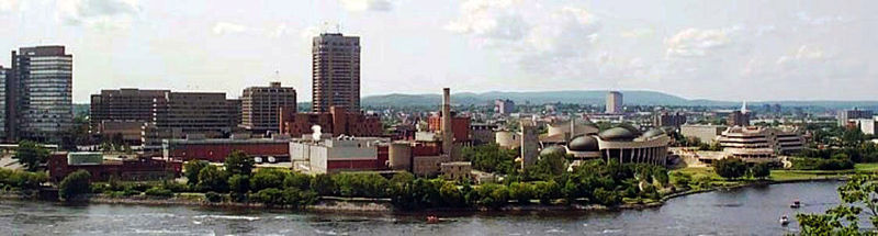
ChamplainWebsite www.ville.gatineau.qc.ca Gatineau is a city in western Quebec, Canada. It is the fourth largest city in the province. It is located on the northern banks of the Ottawa River, immediately across from Ottawa, Ontario, and together they form Canada's National Capital Region. Ottawa and Gatineau comprise a single Census Metropolitan Area. Gatineau had a population of 242,124, and metropolitan population of 1,130,761, as of the 2006 census. In 2009 it had an estimate population of 301,416, and metropolitan estimate of 1,220,674.[2]
Gatineau is coextensive with a territory equivalent to a regional county municipality (TE) and census division (CD) of the same name, whose geographical code is 81. It is the seat of the judicial district of Hull.[3]
Contents
History
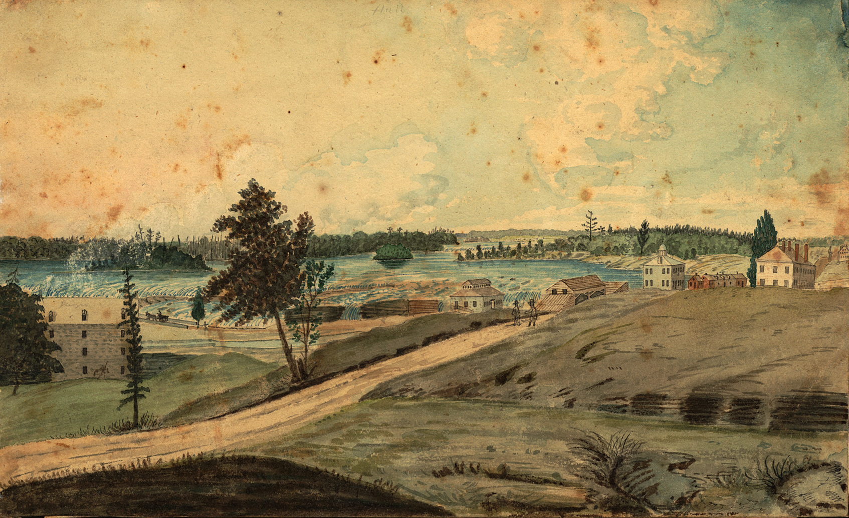
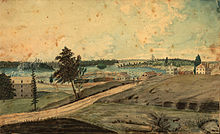 1830 painting of Wright's Town by Thomas Burrowes, with the Chaudière Falls and Bytown visible in the background
Gatineau is a former municipality in the Province of Quebec and the location of the oldest non-native settlement in the National Capital Region. It was founded on the north shore of the Ottawa River in 1800 by Philemon Wright at the portage around the Chaudière Falls just upstream (or west) from where the Gatineau and Rideau Rivers flow into the Ottawa. Wright brought his family, five other families and twenty-five labourers[4] and a plan to establish an agriculturally based community to what was a mosquito-infested wilderness. But soon after, Wright and his family took advantage of the large lumber stands and became involved in the timber trade. The original settlement was called Wrightstown, later it became Hull and in 2002, after amalgamation, the City of Gatineau.
In 1820, before immigrants from Great Britain arrived in great numbers, Hull Township had a population of 707, including 365 men, 113 women, and 229 children. Note the discrepancy in the number of men and women, owing to the male work of the timber trade. In 1824, there were 106 families and 803 persons. During the rest of the 1820s, the population of Hull doubled, owing to the arrival of Ulster Protestants. By 1851, the population of the County of Ottawa was 11,104, of which 2,811 lived in Hull Township. By comparison, Bytown had a population of 7,760 in 1851. By 1861, Ottawa County now had a population of 15,671, of which 3,711 lived in Hull Township. The gradual move to the Township by French Canadians continued over the years, with the French Canadians growing from 10% of the population in 1850, to 50% in 1870, and 90% in 1920.[5]
The carspreserve of the draveurs, people who would use the river to transport logs from lumber camps until they arrived downriver. (The Gatineau River flows south into the Ottawa River which flows east to the St Lawrence River near Montreal.) The log-filled Ottawa River, as viewed from Hull, appeared on the back of the Canadian one-dollar bill until it was replaced by a dollar coin (the "loonie") in 1987, and the very last of the dwindling activity of the draveurs on these rivers ended a few years later.
Ottawa was founded later, as the terminus of the Rideau Canal built under the command of Col. John By as part of fortifications and defences constructed after the War of 1812. Originally named Bytown, Ottawa did not become the Canadian capital until the mid-19th century after the original parliament in Montreal was torched by a rioting mob of English-speaking citizens on April 25, 1849. Its greater distance from the American border also left the new parliament less vulnerable to foreign attack.
Nothing remains of the original 1800 settlement; the downtown Vieux-Hull sector was destroyed by a terrible fire in 1900 which also destroyed the original pont des Chaudières (Chaudière Bridge), a road bridge which has since been rebuilt to join Ottawa to Hull at Victoria Island.
In the 1940s, during World War II, Hull, along with various other regions within Canada, such as the Saguenay, Lac Saint-Jean, and Île Sainte-Hélène, had Prisoner-of-war camps.[6] Hull's prison was simply labeled with a number and remained unnamed just like Canada's other war prisons.[6][7] The prisoners of war (POWs) were sorted and classified into categories by nationality and civilian or military status.[6] In this camp, POWs were mostly Italian and German nationals. During the Conscription Crisis of 1944 the prison eventually included Canadians who had refused conscription.[6] Also, prisoners were forced into hard labour which included farming and lumbering the land.[6]
During the 1970s and early 1980s, the decaying old downtown core of Hull was transformed by demolition and replacement with a series of large office complexes. Some 4,000 residents were displaced, and many businesses uprooted along what was once the town's main commercial area.[8]
Amalgamation
In 2002, the Parti Québécois, leading the provincial government, merged 5 municipalities to form the new city of Gatineau. Although Hull was the oldest and most central of the merged cities, the name Gatineau was chosen for the new city. The main reasons given were that Gatineau had more inhabitants, it was the name of the former county, the valley, the hills, the park and the main river within the new city limits: thus its name was less restrictive than Hull. Some argued that the French name of Gatineau was more appealing than a name from England to most French-speaking residents. Since the former city of Hull represents a large area distinct from what was formerly known as Gatineau, to be officially correct and specific many people say "vieux secteur Hull" (the former Hull part of town) when speaking of it. It is of note that the name "Hull" was often informally used to refer to the whole urban area on the northern shore of the river facing Ottawa, so much so that the National Capital Region was often referred to as "Ottawa-Hull", especially in Quebec outside the immediate area.
In 2004, there was a referendum to decide whether Hull would remain in Gatineau. The majority of those who voted in Hull voted against the deamalgamation, and the status quo prevailed.
Former Muncipalities (5)
- Gatineau
- Aylmer
- Buckingham
- Hull
- Masson-Angers
Economy
A number of federal and provincial government offices are located in Gatineau, due to its proximity to the national capital, and its status as the main town of the Outaouais region of Quebec.
A policy of the federal government to distribute federal jobs on both sides of the Ottawa River led to the construction of several massive office towers to house federal civil servants in downtown Gatineau; the largest of these are Place du Portage and Terrasses de la Chaudière, occupying part of the downtown core of the city. Some government agencies and ministries headquartered in Gatineau are the Canadian International Development Agency, Public Works and Government Services Canada and the Transportation Safety Board of Canada.[9]
Recreation
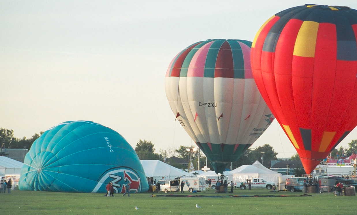
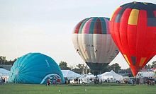 Filling the balloons in the park
Two important tourist attractions located in Gatineau are the Canadian Museum of Civilization and the Casino du Lac Leamy. In August, the Casino hosts an international fireworks competition which opposes four different countries with the winner being awarded a Prix Zeus prize for the best overall show (based on several criteria) and can return in the following year. At the beginning of September, on Labour Day weekend, Gatineau hosts an annual hot air balloon festival which fills the skies with colourful gas-fired passenger balloons.
There are many parks. Some of them are well gardened playgrounds or resting spaces while others, like Lac Beauchamp Park, are relatively wild green areas which often merge with the woods and fields of the surrounding municipalities. Streams of all sizes run through these natural expanses. Most of the city is on level ground but the Northern and Eastern parts lie on the beginnings of the foothills of the massive Canadian Shield, or Laurentian mountains. These are the "Gatineau Hills", and are visible in the background of the companion picture. One of Gatineau's urban parks, Jacques Cartier Park, is used by the National Capital Commission during the popular festival, Winterlude.
Education
The city contains a campus of the Université du Québec, the Université du Québec en Outaouais (UQO).
It is also the home of two provincial junior colleges (or CEGEPs): the francophone CEGEP de l'Outaouais and the anglophone Heritage College.
The National Autonomous University of Mexico (UNAM) has a campus in Gatineau.
The main French-language school boards in Gatineau are the Commission scolaire des Portages-de-l'Outaouais, the Commission scolaire au Coeur-des-Vallées and the Commission scolaire des Draveurs.
Primary and secondary education in English is under the supervision of the Western Quebec School Board.
Transportation
The Gatineau-Ottawa Executive Airport is Gatineau's municipal airport, capable of handling small jets. There are Canada customs facilities for aircraft coming from outside Canada, a car rental counter and a restaurant. Various past attempts to provide regularly scheduled flights from Gatineau's airport had been unsuccessful. Most residents of Gatineau used the nearby Ottawa Macdonald-Cartier International Airport, or travel to Montréal-Pierre Elliott Trudeau International Airport in Montreal. Since September 2003 however Expresso has been operating regularly scheduled direct flights from Gatineau airport to Quebec City.
Ottawa and Gatineau have two distinct bus-based public transit systems with different fare structures, OC Transpo and the Société de transport de l'Outaouais. Tickets are not interchangeable between the two, however passes and transfers from one system to the other do not require payment of a surcharge on any routes.
Many Gatineau highways and major arteries feed directly into the bridges crossing over to Ottawa, but once there the roads land into the dense downtown grid or into residential areas, with no easy connection to the main highway in Ottawa, the East-West 417 or Queensway. This difficulty is further magnified by the lack of a major highway on the Quebec side of the Ottawa River connecting Gatineau to Montreal, the metropolis of the province; most travellers from Gatineau to Montreal first cross over to Ottawa, and use Ontario highways to access Montreal. However, it is expected that Autoroute 50's gap between Gatineau and Lachute will be completed by 2010, making a new link between Gatineau and the Laurentians popular tourist area, and may serve as part of a Montreal by-pass by the north shore for Outaouais residents.
Key roads
Main article: List of Gatineau roadsGatineau City Council
Main article: Gatineau City CouncilThe Gatineau Municipal Council (French: Le conseil municipal de Gatineau) is the city's main governing body. It is composed of 17 city councillors and a mayor.
Media
Main article: Media in Ottawa-GatineauGatineau is the city of license for several television and radio stations, although many more stations licensed to Ottawa are also available in the area. Both cities are generally considered to constitute a single media market, and many of the region's TV and FM broadcast stations transmit from the Ryan Tower site at Camp Fortune just north of Gatineau. All of the stations licensed directly to Gatineau broadcast in French.
Weekly newspapers published in Gatineau include Le Bulletin d'Aylmer (bilingual) and The West Quebec Post. Gatineau does not have its own daily newspaper, but is served by daily newspapers published in Ottawa, including the French Le Droit and the English Ottawa Citizen and Ottawa Sun.
Population and demographics
According to the 2006 census the city of Gatineau had a population of 242,124. This was an increase of 6.8% compared to 2001. There were 104,607 private dwellings on a surface area of 342 km² and a population density of 707 persons per km². Most of the citizens of the new city live in the urban cores of Aylmer, Hull and the former Gatineau. Buckingham and Masson-Angers are more rural communities. Gatineau is the fourth largest city in Quebec after Montreal, Quebec City and Laval.
The Quebec portion, the Gatineau Urban Area, has a population of 212,448 and an area of 136 km². The Quebec regional portion of Gatineau Census Metropolitan Area (CMA) -- which includes the municipalities of Val-des-Monts (population 9,539), Cantley (7,928), La Pêche (7,477), Chelsea (6,703), Pontiac (5,238), L'Ange-Gardien (4,348), and Denholm (604) -- had a total population of 283,959.
The following statistics refer to the Quebec portion of the Ottawa – Gatineau CMA: Aboriginal status: ml/m/.m/peoples comprise 2.7% of the population.[10]
Languages: Counting both single and multiple responses, French was a mother tongue for 80.0% of residents in 2006, English for 13.9%, Arabic for 1.7%, Portuguese for 1.1% and Spanish for 1.0%.[11] (Figures below are for single responses only.)[12]
Census Gatineau Pop. Hull Pop. 1871 x 3,800 1881 x 6,890 1891 x 11,264 1901 x 13,993 1911 x 18,222 1921 x 24,117 1931 x 29,433 1941 2,822 32,604 1951 5,771 43,483 1961 13,022 56,929 1971 22,321 63,580 1981 74,988 56,225 1991 92,284 60,707 2001 102,898 66,246 2006 242,124 x Mother tongue Population Percentage French 220,970 78.5% English 35,580 12.6% Arabic 4,450 1.6% Portuguese 2,845 1.1% Spanish 2,820 1.0% Chinese 1,205 0.4% Serbo-Croatian 635 0.2% Romanian 620 0.2% German 590 0.2% Berber 475 0.2% Polish 465 0.2% Mother tongue Population Percentage Italian 445 0.2% Creole 380 0.1% Russian 370 0.1% Kirundi 350 0.1% Persian 345 0.1% Lao 290 0.1% Bosnian 250 0.1% Dutch 235 0.1% Serbian 230 0.1% Kinyarwanda 225 0.1% Hungarian 220 0.1% Mother tongue Population Percentage English and French 3,345 1.2% English and a non-official language 240 0.1% French and a non-official language 940 0.3% English, French and a non-official language 115 ~
Religion: About 83% of the population identified as Roman Catholic in 2001 while 7% said they had no religion and 5% identified as Protestant (1.3% Anglican, 1.3% United, 0.7% Baptist, 0.3% Lutheran, 0.2% Pentecostal, 0.2% Presbyterian). About 1% of the population identified as Muslim, 0.5% as Jehovah’s Witnesses, 0.3% as Buddhist, and 0.2% as Eastern Orthodox.[13]Visible minorities: The 2001 census found that 4.3% of the population self-identified as having a visible minority status, including, among others, about 1.3% who self-identified as Black, about 1.0% self-identifying as Arab, 0.5% as Latin American, 0.4% as Chinese, 0.3% as Southeast Asian, 0.2% as South Asian, and about 0.1% as Filipino. (Statistics Canada terminology is used throughout.)[14]
Immigration: The area is home to more than five thousand recent immigrants (i.e. those arriving between 2001 and 2006), who now comprise about two percent of the total population. 11% of these new immigrants have come from Colombia, 10% from China, 7% from France, 6% from Lebanon, 6% from Romania, 4% from Algeria, 3% from the United States and 3% from Congo.[15]
Internal migration: Between 2001 and 2006 there was a net influx of 5,205 people (equivalent to 2% of the total 2001 population) who moved to Gatineau from outside of the Ottawa - Gatineau area. There was also a net outmigration of 630 anglophones (equivalent to 2% of the 2001 anglophone population). Overall there was a net influx of 1,100 people from Quebec City, 1,060 from Montreal, 545 from Saguenay, 315 from Toronto, 240 from Trois-Rivières, 225 from Kingston, and 180 from Sudbury.[16]
Ethnocultural ancestries: Canadians were able to self-identify one or more ethnocultural ancestries in the 2001 census. (Percentages may therefore add up to more than 100%.) The most common response was Canadian / Canadien and since the term 'Canadian' is as much an expression of citizenship as of ethnicity these figures should not be considered an exact record of the relative prevalence of different ethnocultural ancestries. 43.1% of respondents gave a single response of Canadian / Canadien while a further 26.5% identified both Canadian / Canadien and one or more other ethnocultural ancestries. 10.4% of respondents gave a single response of French, 1.1% gave a single response of Portuguese, 1.0% gave a single response of Irish, 0.9% gave a single response of Lebanese, 0.8% gave a single response of English, 0.7% gave a single responses of Québécois and 0.7% gave a single response of North American Indian. Counting both single and multiple responses, the most commonly identified ethnocultural ancestries were:
2006 % 2001 % Canadian / Canadien 69.6% French 37.6% Irish 7.6% English 6.4% Scottish 3.8% North American Indian 3.4% German 2.4% Portuguese 1.4% Italian 1.4% 2006 % 2001 % Lebanese 1.2% Métis 1.1% Polish 0.8% Belgian 0.6% Spanish 0.5% Dutch (Netherlands) 0.5% Chinese 0.5% Haitian 0.4% Ukrainian 0.4% American (USA) 0.4% The data to the left is also presented more geographically by Statistics Canada as: 70.7% North American, 37.8% French, 14.3% British Isles, 4.5% Aboriginal, 4.0% Southern European, 3.8% Western European, 1.9% Arab, 1.7% Eastern European, 1.0% East and Southeast Asian, 0.8% African, 0.7% Latin, Central and South American, 0.7% Caribbean and 0.5% Northern European.
(Percentages may total more than 100% due to rounding and multiple responses).Communities
See also: Neighbourhoods of GatineauThe larger communities within Gatineau are:
- Aylmer
- Bassin-du-Lièvre
- Beau-Mont Acres
- Buckingham
- Cousineau
- Farmers Rapids
- Gatineau
- Hull
- Ironside
- Jeanne-d'Arc
- Masson-Angers
- Quinnville
- Simmons
Geographic location

Chelsea, Cantley, Val-des-Monts, L'Ange-Gardien Pontiac 
Lochaber-Partie-Ouest  Gatineau

Ottawa River
Bridges to Ottawa, OntarioSee also
- Chemin de fer de l'Outaouais
- Hull-Chelsea-Wakefield Railway
- List of communities in Quebec
- List of crossings of the Ottawa River
- Mayor of Gatineau
- Municipal reorganization in Quebec
- Twin cities
References
- ^ Ville de Gatineau (1933-1974) - Armoiries
- ^ a b "Population and dwelling counts, for Canada and census subdivisions (municipalities), 2006 and 2001 censuses - 100% data". 2006 Canadian Census. http://www12.statcan.ca/english/census06/data/popdwell/Table.cfm?T=301&S=3&O=D. Retrieved 2007-10-10.
- ^ Territorial Division Act. Revised Statutes of Quebec D-11.
- ^ John H. Taylor, Ottawa: An Illustrated History, James Lorimer & Company, Publishers, Toronto, 1986, p.11
- ^ Martin, Michael, Working Class Culture and the Development of Hull QC pg 48, 2006, online: [1]
- ^ a b c d e Tremblay, Robert, Bibliothèque et Archives Canada, et all. "Histoires oubliées – Interprogrammes : Des prisonniers spéciaux" Interlude. Aired: 20 July 2008, 14h47 to 15h00.
- ^ Note: See also List of POW camps in Canada.
- ^ Harold Kalman and John Roaf, Exploring Ottawa: an architectural guide to the nation's capital. Toronto: University of Toronto Press, 1983. pg. 88
- ^ "Contact Us." Transportation Safety Board of Canada. Retrieved on May 31, 2009.
- ^ "Ottawa - Gatineau (Que. part - Partie Qc)". Aboriginal Identity (8), Sex (3) and Age Groups (12) for the Population of Canada, Provinces, Territories, Census Metropolitan Areas and Census Agglomerations, 2006 Census - 20% Sample Data. Statistics Canada. 2008-01-15. http://www12.statcan.ca/english/census06/data/topics/RetrieveProductTable.cfm?ALEVEL=3&APATH=3&CATNO=&DETAIL=0&DIM=&DS=99&FL=0&FREE=0&GAL=0&GC=99&GK=NA&GRP=1&IPS=&METH=0&ORDER=1&PID=89122&PTYPE=88971&RL=0&S=1&ShowAll=No&StartRow=1&SUB=0&Temporal=2006&Theme=73&VID=0&VNAMEE=&VNAMEF=&GID=837989. Retrieved 2008-02-06.
- ^ "Ottawa - Gatineau (Que. part - Partie Qc)". Detailed Mother Tongue (148), Single and Multiple Language Responses (3) and Sex (3) for the Population of Canada, Provinces, Territories, Census Metropolitan Areas and Census Agglomerations, 2006 Census - 20% Sample Data. Statistics Canada. 2007-11-20. http://www12.statcan.ca/english/census06/data/topics/RetrieveProductTable.cfm?ALEVEL=3&APATH=3&CATNO=&DETAIL=0&DIM=&DS=99&FL=0&FREE=0&GAL=0&GC=99&GK=NA&GRP=1&IPS=&METH=0&ORDER=1&PID=89186&PTYPE=88971&RL=0&S=1&ShowAll=No&StartRow=1&SUB=701&Temporal=2006&Theme=70&VID=0&VNAMEE=&VNAMEF=&GID=837989. Retrieved 2008-02-06.
- ^ "Ottawa - Gatineau (Que. part - Partie Qc)". Detailed Mother Tongue (186), Knowledge of Official Languages (5), Age Groups (17A) and Sex (3) for the Population of Canada, Provinces, Territories, Census Metropolitan Areas and Census Agglomerations, 2001 and 2006 Censuses - 20% Sample Data. Statistics Canada. 2007-11-20. http://www12.statcan.ca/english/census06/data/topics/RetrieveProductTable.cfm?ALEVEL=3&APATH=3&CATNO=&DETAIL=0&DIM=&DS=99&FL=0&FREE=0&GAL=0&GC=99&GK=NA&GRP=1&IPS=&METH=0&ORDER=1&PID=89201&PTYPE=88971&RL=0&S=1&ShowAll=No&StartRow=1&SUB=701&Temporal=2006&Theme=70&VID=0&VNAMEE=&VNAMEF=&GID=837989. Retrieved 2008-02-06.
- ^ "Ottawa - Hull (Que. part - Partie Qc)". Religion (95A), Age Groups (7A) and Sex (3) for Population, for Canada, Provinces, Territories, Census Metropolitan Areas and Census Agglomerations, 1991 and 2001 Censuses - 20% Sample Data. Statistics Canada. 2007-03-01. http://www12.statcan.ca/english/census01/products/standard/themes/RetrieveProductTable.cfm?Temporal=2001&PID=55822&APATH=3&METH=1&PTYPE=55440&THEME=56&FOCUS=0&AID=0&PLACENAME=0&PROVINCE=0&SEARCH=0&GC=99&GK=NA&VID=0&VNAMEE=&VNAMEF=&FL=0&RL=0&FREE=0&GID=431577. Retrieved 2008-02-06.
- ^ "Ottawa - Hull (Que. part - Partie Qc)". Visible Minority Groups (15) and Immigrant Status and Period of Immigration (11) for Population, for Canada, Provinces, Territories, Census Metropolitan Areas 1 and Census Agglomerations, 2001 Census - 20% Sample Data. Statistics Canada. 2007-03-01. http://www12.statcan.ca/english/census01/products/standard/themes/RetrieveProductTable.cfm?Temporal=2001&PID=62913&APATH=3&METH=1&PTYPE=55440&THEME=44&FOCUS=0&AID=0&PLACENAME=0&PROVINCE=0&SEARCH=0&GC=0&GK=0&VID=0&VNAMEE=&VNAMEF=&FL=0&RL=0&FREE=0&GID=431577. Retrieved 2008-02-06.
- ^ "Ottawa - Gatineau (Que. part - Partie Qc)". Immigrant Status and Period of Immigration (8) and Place of Birth (261) for the Immigrants and Non-permanent Residents of Canada, Provinces, Territories, Census Metropolitan Areas and Census Agglomerations, 2006 Census - 20% Sample Data. Statistics Canada. 2007-12-04. http://www12.statcan.ca/english/census06/data/topics/RetrieveProductTable.cfm?ALEVEL=3&APATH=3&CATNO=&DETAIL=0&DIM=&DS=99&FL=0&FREE=0&GAL=0&GC=99&GK=NA&GRP=1&IPS=&METH=0&ORDER=1&PID=89424&PTYPE=88971&RL=0&S=1&ShowAll=No&StartRow=1&SUB=0&Temporal=2006&Theme=72&VID=0&VNAMEE=&VNAMEF=&GID=837989. Retrieved 2008-02-06.
- ^ "Ottawa - Gatineau (Que. part - Partie Qc)". Census Metropolitan Area of Residence 5 Years Ago (37), Mother Tongue (8), Immigrant Status and Period of Immigration (9), Age Groups (16) and Sex (3) for the Inter-Census Metropolitan Area Migrants Aged 5 Years and Over of Census Metropolitan Areas, 2006 Census - 20% Sample Data. Statistics Canada. 2007-03-01. http://www12.statcan.ca/english/census06/data/topics/RetrieveProductTable.cfm?Temporal=2006&PID=89182&GID=843983&METH=1&APATH=3&PTYPE=88971&THEME=71&AID=&FREE=0&FOCUS=&VID=0&GC=99&GK=NA&RL=0&d1=0&d2=0&d3=0&d4=0. Retrieved 2008-02-06.
External links
Administrative divisions of Outaouais (Region 07)Regional county municipalities
and equivalent territoriesPapineau · Gatineau · Les Collines-de-l'Outaouais · La Vallée-de-la-Gatineau · Pontiac
Municipalities Thurso · Gatineau · Val-des-Monts · Cantley · Chelsea · Pontiac · La Pêche · Gracefield · Maniwaki
Administrative divisions of QuebecSubdivisions Communities Major cities Montreal · Quebec · Laval · Gatineau · Longueuil · Sherbrooke · Saguenay · Lévis · Trois-Rivières
Other cities Alma · Amos · Baie-Comeau · Belœil · Châteauguay · Cowansville · Dolbeau-Mistassini · Drummondville · Granby · Joliette · La Tuque · Lachute · Matane · Mont-Laurier · Rimouski · Rivière-du-Loup · Rivière-Rouge · Rouyn-Noranda · Saint-Georges · Saint-Hyacinthe · Saint-Jean-sur-Richelieu · Saint-Jérôme · Salaberry-de-Valleyfield · Sept-Îles · Shawinigan · Sorel-Tracy · Thetford Mines · Val-d'Or · Varennes · Victoriaville
Regions Abitibi-Témiscamingue · Bas-Saint-Laurent · Capitale-Nationale · Centre-du-Québec · Chaudière-Appalaches · Côte-Nord · Estrie · Gaspésie–Îles-de-la-Madeleine · Laval · Lanaudière · Laurentides · Mauricie · Montérégie · Montréal · Nord-du-Québec · Outaouais · Saguenay–Lac-Saint-Jean
Census metropolitan areas (CMAs) in Canada by size Toronto, ON · Montreal, QC · Vancouver, BC · Ottawa, ON · Calgary, AB · Edmonton, AB · Quebec City, QC · Winnipeg, MB · Hamilton, ON · London, ON · Cambridge-Kitchener-Waterloo, ON · St. Catharines-Niagara, ON · Halifax, NS · Oshawa, ON · Victoria, BC · Windsor, ON · Saskatoon, SK · Regina, SK · Sherbrooke, QC · St. John's, NL · Barrie, ON · Kelowna, BC · Abbotsford, BC · Greater Sudbury, ON · Kingston, ON · Saguenay, QC · Trois-Rivières, QC · Guelph, ON · Moncton, NB · Brantford, ON · Thunder Bay, ON · Saint John, NB · Peterborough, ON
Categories:- Gatineau
- Territories equivalent to a regional county municipality
- Quebec communities with significant anglophone populations

Wikimedia Foundation. 2010.