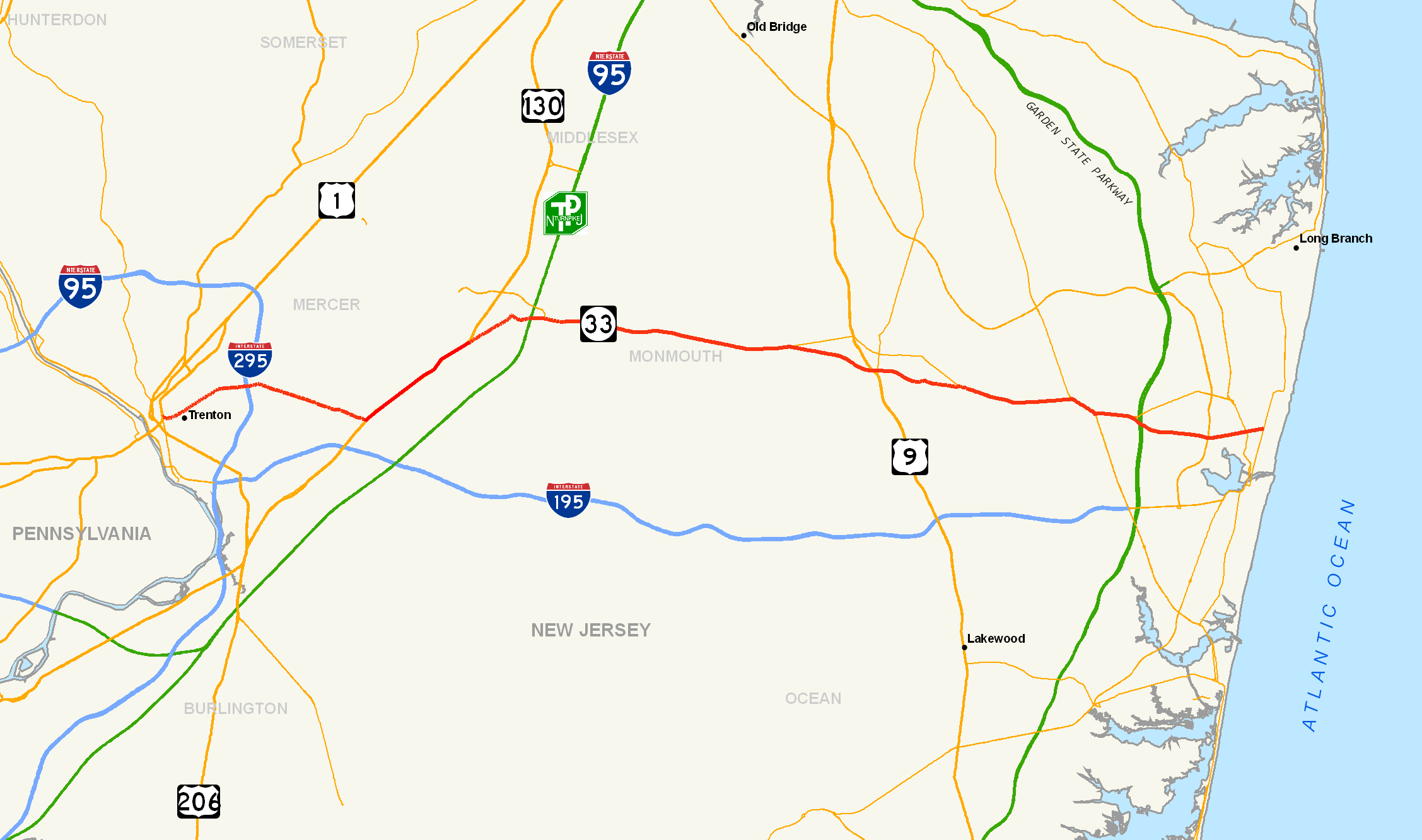
- New Jersey Route 33
-
Route 33
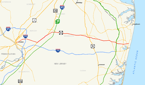
Route information Maintained by NJDOT and Mercer County Length: 42.03 mi[1] (67.64 km) Existed: 1927 – present Major junctions West end: 
 US 1 / Route 129 in Trenton
 I-295 in Hamilton Township
 US 130 in Robbinsville Township

 I-95 / NJ Turnpike in East Windsor
 Route 133 in East Windsor
 US 9 in Freehold Township
 Route 34 in Howell Township
 G.S. Pkwy. in Tinton Falls
 Route 18 in Neptune Township
 Route 35 in Neptune Township
East end:  Route 71 in Neptune Township
Highway system New Jersey State Highway Routes
Interstate and US←  Route 32
Route 34 →Route 33 is a state highway in the U.S. state of New Jersey. The highway extends 42.03 miles (67.64 km), from Trenton at an intersection with U.S. Route 1 and Route 129 to an intersection with Route 71 in Neptune Township. The speed limit on Route 33 differs in zones. The highest is 55 mph (85 km/h) in Zone 9.[2] There are several intersections on 33 with future developments.
Route 33 begins in Trenton on a two-lane road. It passes through central Mercer County, joining northbound U.S. Route 130 in Robbinsville Township. It leaves the U.S. highway in East Windsor and becomes a local town road into the borough of Hightstown. It turns east again and interchanges with the New Jersey Turnpike at Exit 8. As it passes the east end of the Hightstown Bypass, it becomes a divided arterial with four lanes as it makes its way through Monmouth County toward the shore. Around Freehold, it becomes a freeway. It then crosses the Garden State Parkway's Exit 100 in Tinton Falls and Route 18 in Neptune. Here, it is locally known as Corlies Avenue. Route 33 ends at Route 71 in Neptune. It has two concurrencies along the route, one with Route 34 and the second with US 130.
Contents
Route description

On its way across central New Jersey, Route 33 traverses three counties: Mercer, Middlesex, and Monmouth.[1] Beginning in Trenton as Greenwood Avenue, Route 33 is a two-lane road, with one lane in each direction. Once it merges with U.S. Route 130 in Robbinsville Township, Route 33 has two lanes in each direction.[1] After crossing into East Windsor Township, Route 33 veers off and becomes a local road going into Hightstown. After passing through the center of town, Route 33 again enters East Windsor Township, crossing the border at its interchange with the New Jersey Turnpike. After the overpass for the turnpike interchange, Route 33 becomes an avenue with a total of at least four lanes with two lanes in each direction.[1] Route 33 then crosses into Monroe Township, where it is slowly becoming a residential access road for new communities. It then continues into Millstone Township as a rural avenue. Continuing into Manalapan Township, the avenue again becomes a residential access road. At the ramp for Route 33 Business, the avenue turns into a freeway bypass, known as the Freehold Bypass. Route 33 bypasses Freehold Borough to the south staying within Freehold Township. Within Freehold Borough, Route 33 Business is the original alignment of Route 33 before the bypass was built.
The bypass of Freehold is the partial alignment of what would have been a Route 33 freeway from Neptune to Trenton. As time went on, a scaled back version of just a bypass was agreed upon. The western start of the freeway is just east of County Route 527, and was built from Route 33 Business to U.S. Route 9 in the 1970s. The next section was built from U.S. Route 9 across Route 79 to Halls Mill Road (County Route 55), and this remained its terminus from the late 1980s until January 17, 2003, when the final leg of the bypass was opened.[3] East of Halls Mills Road, it is a two-lane freeway with a westbound entrance at Howell Road, and full access from Fairfield Road.
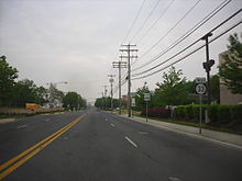 Route 33 westbound in Neptune
The Howell Road eastbound exit ramp has been closed since the bypass opened because of safety concerns. The interchange was originally planned to be a partial cloverleaf, but residents near Howell Road were concerned by sprawl and forced the New Jersey Department of Transportation (NJDOT) to scale back the plans. Instead, a diamond interchange was built. This forced drivers wishing to head northbound on Howell Road to make a left turn, which proved to be dangerous because of the limited sight distance caused by the overpass. Now because the NJDOT does not want to pay to fix the problem, the exit has been barricaded since the freeways extension was opened. The ramp has guardrails blocking access and the NJDOT intends to bulldoze what is left.[4][5]
Passing the Fairfield exit, it crosses over Business 33 and the two roads merge together as a two-lane road. Route 33 passes along the southern section of the Naval Weapons Station Earle and then becomes a residential access road. The road then runs concurrent with Route 34 and becomes a divided four-lane avenue as it travels into Wall Township. Routes 33/34 come upon a roundabout and they both split as Route 33 continues east thru a rural section into Tinton Falls. It goes past the intersection with Route 66, past the interchange with the Garden State Parkway, across the highway and into Neptune Township. The road passes through suburban and rural sections until it comes upon the interchange with Route 18. Immediately past the exit, Route 33 borders Neptune City on the south and Neptune Township on the north for a brief stretch before completely re-entering Neptune Township. After it crosses Route 35, the avenue ends and becomes a two-lane road for a brief stretch. Route 33 then ends at Route 71 (just west of Ocean Grove).
History
Route 33 originally was part of the 1920s New Jersey Route 1 in parts of the road south of Hightstown and as Route 7 from Hightstown to its terminus at Route 71. Both roads were changed into Route 33 in the 1927 New Jersey state highway renumbering.[6]
Route 33 was originally planned as a freeway from U.S. Route 1 in Trenton across New Jersey to Route 18 in Neptune. However, in 1967, the NJDOT scaled back proposals to the current seven-mile (11 km) Freehold Bypass. The bypass from near County Route 527 in Manalapan to Halls Mills Road in Freehold was completed and opened in segments from 1971–1988; however, the remainder of the bypass east to Fairfield Road in Howell was not completed until 2003.[3] The project cost $33.7 million in 2003 USD.[3]
For such a small freeway, the Route 33 bypass has more abandoned segments then any other state freeway in New Jersey. Comparatively, Routes 15, 18, 21 and 24 each only have one abandoned portion to them. Here are the three segments on Route 33, in eastbound order.
- The cloverleaf ramp from Route 79 southbound to Route 33 freeway eastbound has been mostly destroyed, to make way for a new reverse jughandle for U.S. Route 9 northbound to Schanck Road. The merging part of the ramp still remains abandoned along the right side of the eastbound freeway.[7]
- The original alignment for the freeway east of Halls Mills Road (CR 55) can be seen now as an NJDOT maintenance shed. The new alignment curves to the left after the interchange, in order to avoid what the NJDOT believed to be a suspected (but never identified) turtle bog habitat. The pavement is accessible from the eastbound on-ramp, but is fenced off.[8]
- Howell Road was never given access from Route 33 eastbound and thus the ramp still remains barricaded off, slowly decaying.[9]
Up until late 1988, Route 33 westbound ran underneath US 130, then merged with 130's southbound lanes. This was because Route 33 ran alongside some railroad tracks at that point, and a massive overpass carried US 130 over both. (Route 33 eastbound also ascended the bridge approach about halfway before branching off like an exit ramp—a sign with flashing lights read "Hightstown, Shore Points" at the fork). But this Hightstown–Windsor rail segment was actually abandoned back in the 1960s. So by 1989, the bridge over Route 33 and the trackbed was removed, with its approaches flattened to grade. Route 33 now meets US 130 at north end of the multiplex with a traffic signal.
At the southern end of the 33/130 multiplex, where Route 33 heads west, an old and narrow bridge used to carry the highway over the aforementioned railroad tracks. In 2009, this overpass was leveled to grade and replaced with a new wide and linear roadway for 33. No railroad grade crossing has been built, as the Robbinsville–Windsor rail segment is out of service.
Until 2003, the 33/130 junction in Robbinsville was configured as an at-grade wye interchange, employing curved ramps for the directional movements. The junction has since been modified to a signalized intersection with ordinary turning lanes. It has also been converted from a T-intersection to a 4-way, with the construction of a new road on the southeast side of US-130.
 Route 33 eastbound at the Howell Road exit ramp, which still remains closed
Future
There are many future developments for Route 33. Heavy traffic and recent studies hint at a possible widening of Route 33 all the way to Route 34 in Wall Township, however this is still only in the proposal phase. Monmouth County is performing a corridor study on Route 33 to determine if any action should happen. The Collingwood Circle is scheduled for replacement with a smaller roundabout, starting Fall 2006. The idea is to slow the traffic down before it enters the new intersection, but with such heavy traffic on both Route 33 and Route 34. It does not seem likely that this will solve the congestion issue and the NJDOT will likely reconstruct it a decade from now like the former Route 35 and Route 36 Circle in Eatontown.[10] There is a planned Route 33 bypass of Robbinsville Township that will run from Washington Boulevard and link up with U.S. Route 130 at South Gold Drive. The former alignment of Route 33 will likely become a Main Street for the new Washington Town Center.[11] Route 33 is being widened from Route 35 to Route 71 in Neptune to provide a center turning lane as well as shoulders. Signals will be modified to provide proper movements.[12]
On December 31, 2006, the Turnpike Authority released its proposals regarding Interchange 8. The current Interchange 8 would be demolished and replaced with a new interchange. The new Exit 8 would end at the intersection with Route 33, Milford Road, and the 133 bypass (on the east side of the expressway, instead of the west). This new Exit 8 would grant direct access to the bypass (without going through any traffic lights), as well as to 33, using grade-separated interchanges. The new toll gate would feature a total of 12 booths at the toll gate.[13] Monmouth County recently gave a tour to DOT officials, stressing the need to improve the Wemrock Road exit off the Route 33 freeway. They also wanted the intersection with Business 33 to be rebuilt. County officials believe that both projects would help with future traffic flow emanating from the planned Freehold Raceway Mall connector road.[14]
Major intersections
County Location Mile[1] Destinations Notes Mercer Trenton 0.00 US 1 / Route 129 southInterchange, western terminus, Market Street continues west to US 206 and NJ 29. Hamilton Township 3.32 I-295I-295 Exit 63 4.07  CR 533 (Whitehorse Mercerville Road)
Robbinsville Township 7.50
7.53 CR 526 (Robbinsville Edinburg Road/Robbinsville Allentown Road)
7.84 US 130 south / CR 526West end of US 130 overlap East Windsor Township 12.39 US 130 northEast end of US 130 overlap Hightstown 14.15 
 CR 539 / CR 571 south (South Main Street)
West end of CR 539/CR 571 overlap 14.21 CR 571 north (Stockton Street)East end of CR 571 overlap 14.28 CR 539 north (North Main Street)East end of CR 539 overlap East Windsor Township 14.77 I-95 / NJ TurnpikeI-95/NJTP Exit 8 15.52 Route 133 westMiddlesex Monroe Township 17.05  CR 619 (Applegarth Road/Butcher Road)
To I-95/NJTP Exit 8A Monmouth Millstone Township 21.10 
 CR 527 Alt. (Iron Ore Road/Woodville Road)
Manalapan Township 24.01 CR 527 (Millhurst Road/Sweetmans Lane)West end of freeway 24.40-24.68 

 Route 33 Bus. east (Old Highway) to US 9 north – Freehold Business District
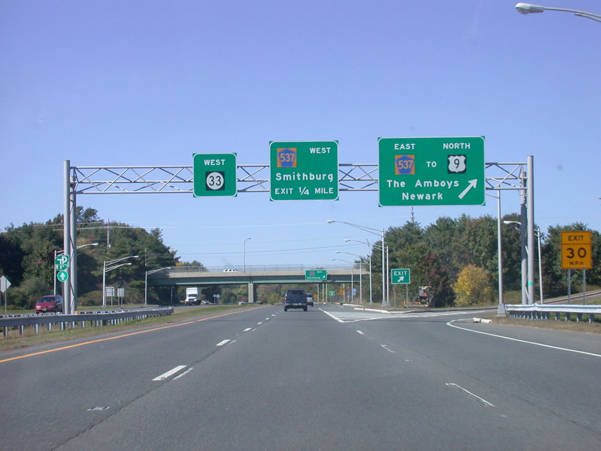
Freehold Township 25.68 Wemrock Road – Monmouth Battlefield State Park 26.59  CR 537 (Freehold Mount Holly Road) to US 9 north – Smithburg, Freehold, The Amboys, Newark
No access from NJ 33 eastbound to CR 537 westbound or from CR 537 eastbound to NJ 33 westbound 27.54 US 9 south – LakewoodAccess from NJ 33 only 27.69  Route 79 north (South Street) – Freehold
No eastbound exit 29.04  CR 55 (Halls Mills Road) – Adelphia
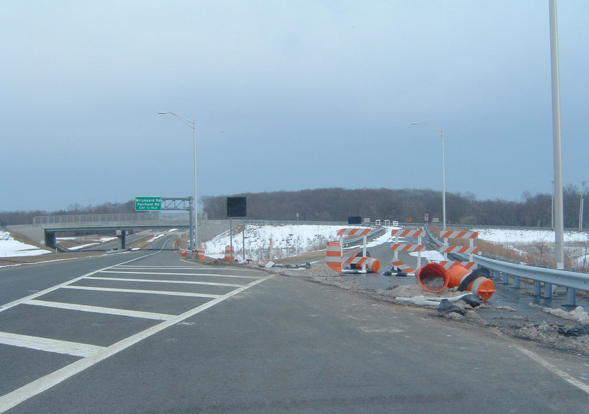
Howell Township 30.04 Howell Road Eastbound exit and westbound entrance, eastbound exit is closed 30.64 Brickyard Road, Fairfield Road Eastbound exit and westbound entrance 30.87
Route 33 Bus. westWestbound exit and eastbound entrance East end of freeway 34.77 Route 34 northWest end of NJ 34 overlap Wall Township 35.76-35.85  Route 34 south / CR 547 south (Asbury Road)
East end of NJ 34 overlap, west end of CR 547 overlap 36.03 CR 547 north (Shafto Road)East end of CR 547 overlap Tinton Falls 37.16  Route 66 east
37.47-37.58 G.S. Pkwy.GSP Exit 100 Neptune Township 40.01-40.03 Route 18NJ 18 Exit 8 41.38 Route 3542.03 Route 71 (Main Street)Eastern terminus 1.000 mi = 1.609 km; 1.000 km = 0.621 mi Business route

Route 33 Business
Location: Freehold Length: 6.89 mi[15] (11.09 km) Existed: 1990–present Route 33 Business is a short state highway in New Jersey that is the original alignment of Route 33 before a freeway was built as a bypass of Freehold. This business route stretches 6.89 miles (11.09 km) through Manalapan Township, Freehold Township, Freehold Borough and Howell Township. The highway holds the distinction of being the only business route state highway in all of New Jersey.
Route 33 Business begins at the interchange with Route 33, its parent route, in Manalapan Township, New Jersey. A short distance after, the interchange from Route 33 eastbound merges into Route 33 Business, and the route passes to the south of Monmouth Battlefield State Park and enters Freehold Township. Soon after entering the borough of Freehold, Route 33 Business interchanges with U.S. Route 9. Route 33 Business turns to the southeast, passing to the north of Freehold Raceway. A short distance later, Route 33 Business intersects at a traffic light with New Jersey Route 79 (South Street) in downtown Freehold. At the intersection with Fairfield Road, Route 33 Business enters the interchange with Route 33 and the freeway, where the designation terminates.[16]
Route 33 Business originates as an alignment of Route 33, designated across the state in the 1927 New Jersey state highway renumbering[17] as a replacement to Routes 1 and 7, which were assigned in the 1920s.[18] The route remained intact for several decades, continuing as the proposals for the crosstown Route 33 Freeway during the 1960s were drawn up. The new Route 33 Freeway was to be 39 miles (63 km) long, starting at U.S. Route 1 in Trenton, crossing through Princeton and into Hightstown, where it would connect with the current-day New Jersey Route 133, heading eastward, where it would connect with the unbuilt Driscoll Expressway in Freehold. The freeway would continue, interchanging with the Garden State Parkway near Exit 100 in Neptune and terminate at the Route 18 freeway in Neptune.[19] However, the next year, the New Jersey Department of Transportation had to scale down the project to a new bypass of Freehold, and prevent the congestion of traffic through the borough.[20] Design studies began that year, and the entire bypass was constructed during the 70s and 80s, with the entire freeway finished in 1988.[21] This new bypass was designated as Route 33 Bypass from 1965[22] until Route 33 was re-aligned off the local roads onto the new freeway in 1990, which at that time, Route 33 Business was designated on the former alignment.[23]
Related routes
See also
 U.S. Roads portal
 New Jersey portal
References
- ^ a b c d e New Jersey Department of Transportation. "Route 33 straight line diagram" (PDF). http://www.state.nj.us/transportation/refdata/sldiag/00000033__-.pdf. Retrieved August 26, 2007.
- ^ New Jersey Department of Transportation. "Speed Limits for Route 33". http://www.state.nj.us/transportation/refdata/traffic_orders/speed/rt33.shtm. Retrieved August 26, 2007.
- ^ a b c Route 33 Bypass to open January 17, 2003, New Jersey Department of Transportation, press release dated January 16, 2003. Accessed June 14, 2007.
- ^ Baratta, Kathy (February 11, 2004). "Howell Road exit from bypass will stay closed". News Transcript. http://newstranscript.gmnews.com/News/2004/0211/Front_Page/042.html. Retrieved December 18, 2006.
- ^ "State should bite the bullet on bypass exit". News Transcript. March 3, 2004. http://newstranscript.gmnews.com/news/2004/0303/Editorials/011.html. Retrieved December 18, 2006.
- ^ New Jersey Department of Transportation. "Route 33 Straight Line Diagram from 2005" (PDF). Archived from the original on October 29, 2003. http://web.archive.org/web/20031029054039/http://www.state.nj.us/transportation/refdata/sldiag/00000033__-.pdf. Retrieved August 26, 2007.
- ^ Mapquest. "View of Route 33/Route 79 interchange". http://www.mapquest.com/maps/map.adp?address=Us%20Highway%209%20%26%20Schanck%20Rd&city=Freehold&state=NJ&zipcode=07728&country=US&title=%3cb%20class%3d%22fn%20org%22%3eUs%20Highway%209%20%26amp%3b%20Schanck%20Rd%3c%2fb%3e%3cbr%20%2f%3e%20%3cspan%20style%3d%22display%3ainline%3bmargin%2dbottom%3a0px%3b%22%20class%3d%22locality%22%3eFreehold%3c%2fspan%3e%2c%20%3cspan%20style%3d%22display%3ainline%3bmargin%2dbottom%3a0px%3b%22%20class%3d%22region%22%3eNJ%3c%2fspan%3e%20%3cspan%20style%3d%22display%3ainline%3bmargin%2dbottom%3a0px%3b%22%20class%3d%22postal%2dcode%22%3e07728%3c%2fspan%3e%2c%20%20%3cspan%20style%3d%22display%3ainline%3bmargin%2dbottom%3a0px%3b%22%20class%3d%22country%2dname%22%3eUS%3c%2fspan%3e%3c%2fspan%3e&cid=lfmaplink2&name=&dtype=a. Retrieved August 26, 2007.
- ^ Mapquest. "View of Route 33/County Route 55 interchange". http://www.mapquest.com/maps/map.adp?address=Okerson%20Rd%20%26%20Halls%20Mill%20Rd&city=Freehold&state=NJ&zipcode=07728&country=US&title=%3cb%20class%3d%22fn%20org%22%3eOkerson%20Rd%20%26amp%3b%20Halls%20Mill%20Rd%3c%2fb%3e%3cbr%20%2f%3e%20%3cspan%20style%3d%22display%3ainline%3bmargin%2dbottom%3a0px%3b%22%20class%3d%22locality%22%3eFreehold%3c%2fspan%3e%2c%20%3cspan%20style%3d%22display%3ainline%3bmargin%2dbottom%3a0px%3b%22%20class%3d%22region%22%3eNJ%3c%2fspan%3e%20%3cspan%20style%3d%22display%3ainline%3bmargin%2dbottom%3a0px%3b%22%20class%3d%22postal%2dcode%22%3e07728%3c%2fspan%3e%2c%20%20%3cspan%20style%3d%22display%3ainline%3bmargin%2dbottom%3a0px%3b%22%20class%3d%22country%2dname%22%3eUS%3c%2fspan%3e%3c%2fspan%3e&cid=lfmaplink2&name=&dtype=a. Retrieved August 26, 2007.
- ^ Mapquest. "Howell Road interchange". http://www.mapquest.com/maps/map.adp?address=Howell%20Rd%20%26%20Vanderveer%20Rd&city=Freehold&state=NJ&zipcode=07728&country=US&title=%3cb%20class%3d%22fn%20org%22%3eHowell%20Rd%20%26amp%3b%20Vanderveer%20Rd%3c%2fb%3e%3cbr%20%2f%3e%20%3cspan%20style%3d%22display%3ainline%3bmargin%2dbottom%3a0px%3b%22%20class%3d%22locality%22%3eFreehold%3c%2fspan%3e%2c%20%3cspan%20style%3d%22display%3ainline%3bmargin%2dbottom%3a0px%3b%22%20class%3d%22region%22%3eNJ%3c%2fspan%3e%20%3cspan%20style%3d%22display%3ainline%3bmargin%2dbottom%3a0px%3b%22%20class%3d%22postal%2dcode%22%3e07728%3c%2fspan%3e%2c%20%20%3cspan%20style%3d%22display%3ainline%3bmargin%2dbottom%3a0px%3b%22%20class%3d%22country. Retrieved August 26, 2007.
- ^ Bartin, Bekir; Kaan Ozbay, Ozlem Yanmaz-Tuzel, and George List. ""MODELING AND SIMULATION OF UNCONVENTIONAL TRAFFIC CIRCLES" (PDF). http://www.mdt.mt.gov/research/docs/trb_cd/Files/06-2710.pdf. Retrieved December 18, 2006.
- ^ New Jersey Department of Transportation. FY 2006-08 Statewide Transportation Improvement.
- ^ New Jersey Department of Transportation. "FY 2005-07 Statewide Transportation Improvement" (PDF). http://www.state.nj.us/transportation/capital/stip0507/route/rt33.pdf. Retrieved December 18, 2006.
- ^ "Pike plan raises concern", The Trenton Times, January 1, 2007.
- ^ "Route 33 & Wemrock improvement from Mall connector", Farmingdale News Transcript, January 24, 2007.
- ^ "Route 33 Business straight line diagram" (PDF). New Jersey Department of Transportation. http://www.state.nj.us/transportation/refdata/sldiag/00000033B_-.pdf. Retrieved December 9, 2009.
- ^ Bing Maps (2009). Overview map of New Jersey Route 33 Business (Map). Cartography by NAVTEQ. http://www.maps.bing.com/maps/?FORM=Z9LH8#JmNwPTQwLjI0Njk0MjU2NDg0NTA4fi03NC4yNzk3MjgyNjM2MTY1NiZsdmw9MTMmc3R5PXImcnRwPXBvcy40MC4yNTQwNjk4NjQ3NDk5MV8tNzQuMzM1OTUwMzE0OTk4NjNfbmVhciUyMFNSLTMzJTJDJTIwRW5nbGlzaHRvd24lMkMlMjBOZXclMjBKZXJzZXklMjAwNzcyNiUyQyUyMFVuaXRlZCUyMFN0YXRlc19fX2FffnBvcy40MC4yNTU0MTA5NjkyNTczNTVfLTc0LjMyNTY1ODY3OTAwODQ4X25lYXIlMjBTUi0zMyUyMEJ1cyUyMCUyNiUyMFJhbXAlMkMlMjBFbmdsaXNodG93biUyQyUyME5ldyUyMEplcnNleSUyMDA3NzI2JTJDJTIwVW5pdGVkJTIwU3RhdGVzX19fYV9+cG9zLjQwLjI1OTM1ODUxMDM3NTAyXy03NC4yOTM3MjY5ODA2ODYxOV9uZWFyJTIwMTIlMjBTUi0zMyUyMEJ1cyUyQyUyMEZyZWVob2xkJTJDJTIwTmV3JTIwSmVyc2V5JTIwMDc3MjglMkMlMjBVbml0ZWQlMjBTdGF0ZXNfX19hX35wb3MuNDAuMjU4NzQ5NjQ4OTI4NjRfLTc0LjI5MDI1NzU0MzMyNTQyX25lYXIlMjBTUi0zMyUyMEJ1cyUyQyUyMEZyZWVob2xkJTJDJTIwTmV3JTIwSmVyc2V5JTIwMDc3MjglMkMlMjBVbml0ZWQlMjBTdGF0ZXNfX19hX35wb3MuNDAuMjQ5NjY3Njg5MjA0MjE2Xy03NC4yNTgwNjQzMjk2MjQxOF84MDAlMjBTdGF0ZSUyMFJvdXRlJTIwMzMlMkMlMjBGcmVlaG9sZCUyQyUyME5KJTIwMDc3MjgtODQzMF9fX2FffnBvcy40MC4yMzQ0NTM1MjkxMTk0OV8tNzQuMjIxOTYyNDY2ODM1OThfX19fYV8mcnRvcD0wfjB+MH4=. Retrieved November 21, 2009.
- ^ State of New Jersey, Laws of 1927, Chapter 319.
- ^ New Jersey Highway Department (1925). State Highway Route map (Map). http://www.jimmyandsharonwilliams.com/njroads/1920s/route05.htm. Retrieved June 23, 2009.
- ^ Transportation 1985: A Regional Plan. Tri-State Transportation Commission. 1966.
- ^ New Jersey Highway Facts. New Jersey Department of Transportation. 1967.
- ^ "Road Halfway Done". The Asbury Park Press (Gannett Newspapers). August 22, 2001.
- ^ ROUTE NO. . Beginning at a point in State Highway Route 33 (1953) west of Freehold and thence proceeding southeastwardly to another point in the said Route 33 (1953) east of Freehold. L.1965, c. 210, s. 2.
- ^ New Jersey Department of Transportation (1991). New Jersey Official Road Map (Map). Cartography by New Jersey Department of Transportation.
External links
- An expanded view of road jurisdiction in Trenton at the confluence of US 1, US 206, NJ 29, NJ 33 and NJ 129
- Photos of Route 33 by Gribblenation.net
- Steve Alpert's NJ 33 Page
Controlled-access highways and Expressways in New Jersey Interstate Highways U.S. and state highways Toll roads and other highways Atlantic City Expressway (Brigantine Connector) • Garden State Parkway • New Jersey Turnpike • Palisades Interstate ParkwayCategories:- State highways in New Jersey
- Two-lane freeways in the United States
- Transportation in Mercer County, New Jersey
- Transportation in Middlesex County, New Jersey
- Transportation in Monmouth County, New Jersey
- Limited access New Jersey state routes


Wikimedia Foundation. 2010.