- County Route 533 (New Jersey)
-
County Route 533
Route information Length: 32.36 mi[1] (52.08 km) Major junctions South end: 
 US 206 / CR 524 in Hamilton Township
 Route 33 in Hamilton Township
 CR 535 in Hamilton Township
 US 1 in West Windsor Township
 CR 583 in Princeton Township
US 206 in Princeton Township
 CR 514 in Millstone

 CR 533 Byp. in Hillsborough Township
North end:  CR 527 in Bound Brook
Highway system County routes in New Jersey
500-series←  CR 532
CR 534  →
→County Route 533 is a county highway in the U.S. state of New Jersey. The highway extends 32.36 miles (52.08 km) from the White Horse Circle, in Hamilton Township to County Route 527 in Bound Brook. Route 533 shares a major concurrency with U.S. Route 206 through Princeton Township, while portions of the roadway in Somerset County are part of the Millstone River Valley Scenic Byway.
Along with Route 206, Route 533 is one of the main roads connecting Mercer and Somerset, as evidenced by the fact the two cross the county line together. It also has a key historic importance, as George Washington used the road during his march from Trenton to Princeton during the American Revolution. This is commemorated by several small stone pillars at various points along the road.
Contents
Route description
White Horse to Princeton
The southern third of Route 533 serves as a shorter, more direct route between two parts of Route 206, connecting the southern portion as it travels north from Bordentown and the northern portion as moves through Princeton and into Somerset County. The U.S. highway turns west down Broad Street at the circle and winds confusingly through the city of Trenton before moving through Lawrence, the county route continues nearly due north through Hamilton and along the Lawrence/West Windsor boundary into Princeton. (Route 524 also begins at the circle, following Broad in the other direction toward Yardville and Allentown)
For its first 3.5 miles (5.6 km) in southern Hamilton, the route is White Horse-Mercerville Road, as it connects the two census-designated places. Along the way, it accesses both interstates 295 (Exit 61) and 195 (Exit 2) via Arena Drive, just 0.42 miles (0.68 km) from the southern terminus. At 3.3 miles (5.3 km), it intersects Route 33, providing access to downtown Trenton and the business-laden stretch of Hamilton Square. Less than a mile later, 533 meets Route 535 and Nottingham Avenue at a five-point intersection, and continues on as Quakerbridge Road.
At this point, the route picks up the trail followed by Washington. At 4.39 miles (7.07 km), it passes Sloan Avenue, which again provides access to I-295 at Exit 65. From here, it continues on to the northern border of Hamilton and follows the border between Lawrence to the west and West Windsor on the east. It crosses Amtrak's Northeast Corridor at 6.70, just north of the Hamilton Transit Complex. It passes the Quaker Bridge Mall complex to the left as it approaches U.S. Route 1, which it crosses at 8.05.
Officially, Quakerbridge becomes Quaker Road, but it is signed as Quakerbridge at the upcoming intersection with Province Line Road, which runs along the old Province Line between East Jersey (Princeton Township) and West Jersey (Lawrence). Upon crossing that line, 533 moves into a heavily wooded area, crossing the Delaware & Raritan Canal at Port Mercer, then the Stony Brook over the Quaker Bridge, winding its way toward Route 583, which is the old turnpike from Trenton to Princeton. It crosses 583 and continues to the start of its concurrency with Route 206.
Concurrency with Route 206
During its six and a half-mile concurrency with Route 206, 533 services Nassau Street (Route 27) in downtown Princeton and Princeton Airport near an intersection with Route 518 in Montgomery Township, just beyond the county line between Mercer and Somerset. Just before the end of the concurrency, the road passes over Bedens Brook.
Montgomery to Bound Brook
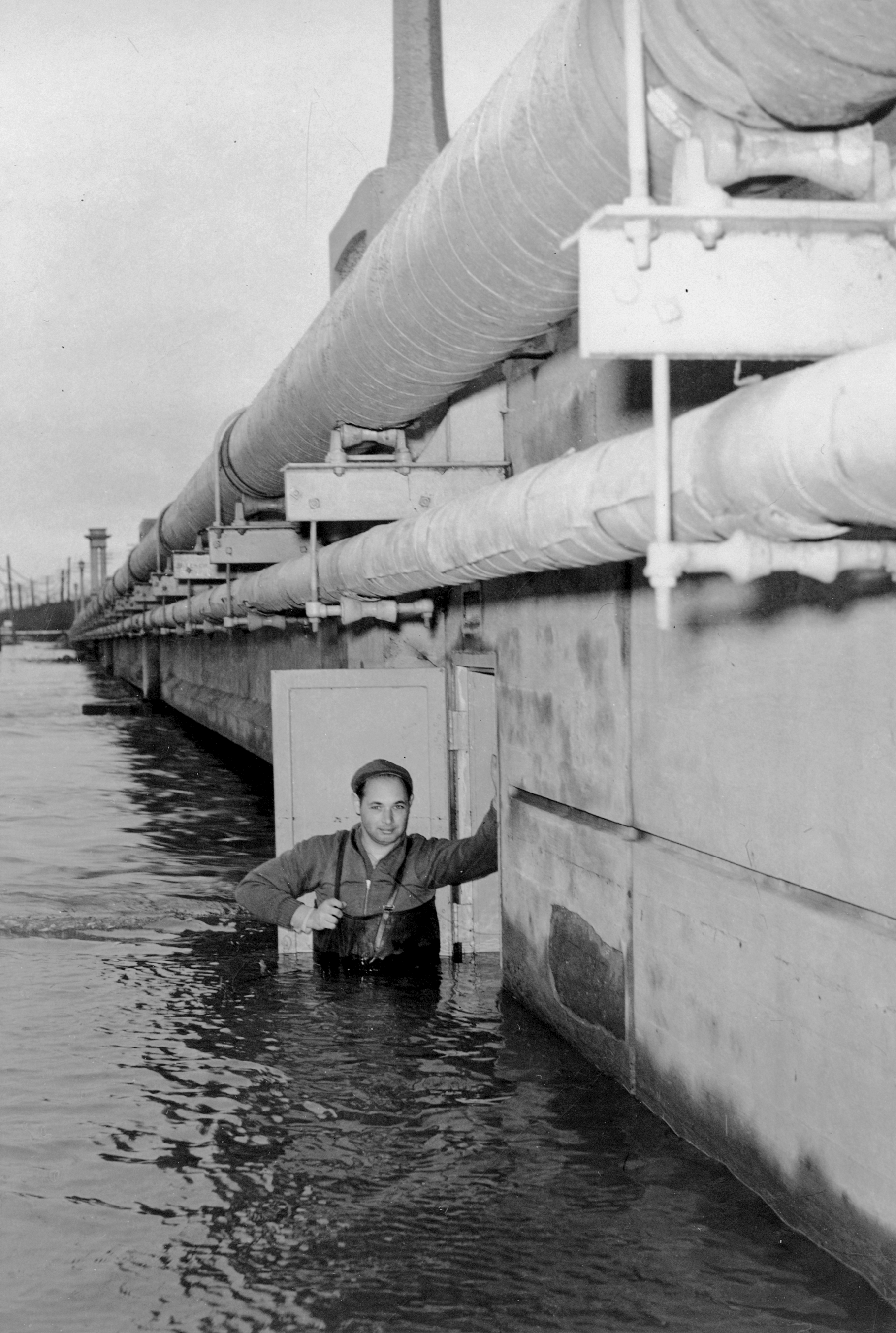
 Photo of a gauge inspector and the Manville, New Jersey gage house built into the North Main Street/CR-533 bridge abutment during the Raritan River flood of December 31, 1948.
Route 533 finally splits off of Route 206 in northern Montgomery at mile marker 17.33, breaking off to the right and running along the western bank of the Millstone River, which is itself parallel to the Delaware & Raritan Canal for this stretch. It is now known as River Road, and there is a Canal Road that also mirrors Route 533 on the far side of the two waterways in Franklin Township.
At 21.59, Route 533 meets Township Line Road from the left, marking the move from Montgomery into Hillsborough. At 24.88, it enters the borough of Millstone for about a mile. Here, it interchanges Amwell Road (Route 514), which provides access to a spur of Route 533. Just before mile marker 26, the route re-enters Hillsborough and meets up with the northern end of the spur.
At 27.19, 533 passes by the Central Jersey Regional Airport, then turns away from the river as it becomes Main Street in the densely packed borough of Manville. After two miles (3 km), Route 533 crosses the Raritan River and enters Bridgewater. At 29.89, Route 533 reaches the downtown Bridgewater, and turns right down its Main Street, traveling almost due east for its remaining two and a half miles. In its busy final mile, it passes by Commerce Bank Ballpark, the Bridgewater Train Station and Interstate 287, enters Bound Brook and reaches its terminus at Route 527. There is no direct access to I-287, but Promenade Boulevard does carry traffic to Route 28 at Exit 13 off the freeway.
Despite the ending of the Route 533 designation, the road itself continues as Route 607. It passes through a traffic circle, where Route 527 leaves to the south toward South Bound Brook, and crosses county lines into the borough of Middlesex, where it ends at an intersection with Route 28.
Major intersections
County Location Mile[1] Destinations Notes Mercer Hamilton Township 0.00 US 206 / CR 524 east (Broad Street)White Horse Circle, southern terminus 3.30 Route 333.51 CR 535 (Nottingham Way/Edinburg Road)West Windsor Township 8.05 US 1Interchange 8.41  CR 569 north (Province Line Road)
Princeton Township 10.42 CR 583 (Mercer Street)10.88 US 206 southSouth end of US 206 overlap Borough of Princeton 12.28  Route 27 north (Nassau Street)
Somerset Montgomery Township 16.41  CR 518 (County Road)
17.33 US 206 north (Van Horne Road)North end of US 206 overlap Millstone 25.52 CR 514 (Amwell Road)Hillsborough Township 25.92
CR 533 Byp. southBound Brook 32.26 CR 527 (Mountain Avenue)Northern terminus 1.000 mi = 1.609 km; 1.000 km = 0.621 mi CR 533 Bypass

County Route 533 Bypass
Location: Millstone - Hillsborough Township Length: 0.45 mi[2] (0.72 km) County Route 533 Bypass (referenced as County Route 533 Spur) is a county highway in the U.S. state of New Jersey. The highway extends 0.45 miles (0.72 km) from Millstone Bypass (CR 514) in Millstone to Millstone River Road (CR 533) in Hillsborough Township.
The road travels through the following municipalities at the specified mileposts (from South to North):
- 0.00-0.25: Millstone Borough (Somerset County)
- 0.25-0.45: Hillsborough Township [2]
See also
 U.S. Roads portal
 New Jersey portal
References
- ^ a b NJDOT County Route 533 Straight Line Diagram (PDF) (NJDOT) (Straight-line diagram)
- ^ a b NJDOT County Route 533 SPUR Straight Line Diagram (PDF) (NJDOT) (Straight line diagram)
External links
Categories:- County routes in New Jersey
- Transportation in Mercer County, New Jersey
- Transportation in Somerset County, New Jersey

Wikimedia Foundation. 2010.