- New Jersey Route 27
-
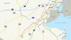
Route 27
Route information Maintained by NJDOT and Middlesex County Length: 38.53 mi[1] (62.01 km) Existed: 1927 – present Major junctions South end: 
 US 206 / CR 533 in Princeton Borough
 Route 18 in New Brunswick
 I-287 in Edison
 G.S. Pkwy. in Woodbridge
 Route 35 in Rahway
 Route 439 in Elizabeth
 Route 28 in Elizabeth
 US 22 in Newark
North end:  Route 21 in Newark
Highway system New Jersey State Highway Routes
Interstate and US←  Route 26
Route 28 →←  CR 625
CR 646  →
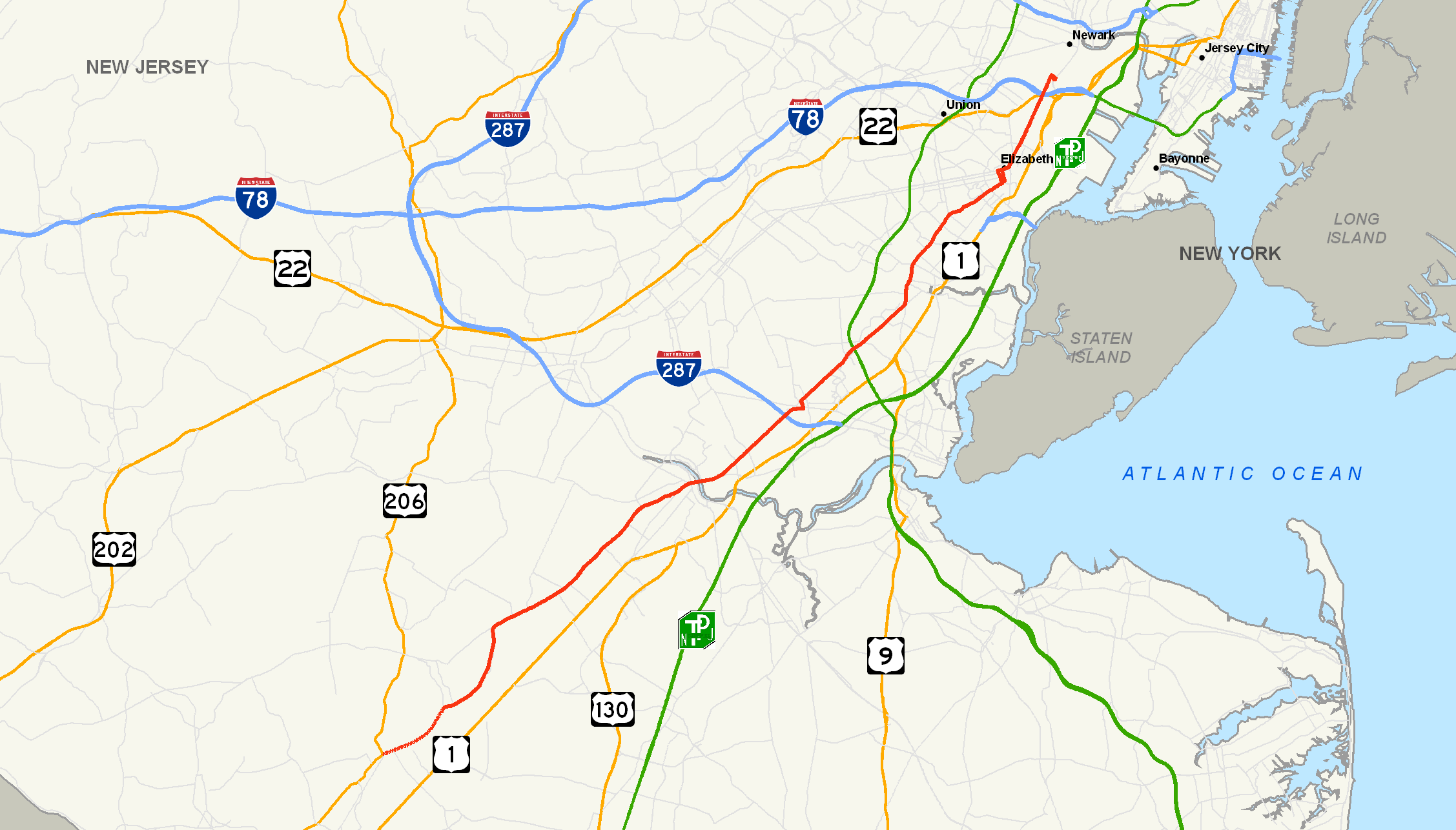
→Route 27 is a state highway in New Jersey, United States. It runs 38.53 mi (62.01 km) from U.S. Route 206 in Princeton Borough, Mercer County northeast to an interchange with Route 21 (McCarter Highway) and Broad Street in Newark, Essex County. The route passes through many communities along the way, including New Brunswick, Metuchen, Rahway, and Elizabeth. Route 27 is a two- to four-lane undivided highway for most of its length, passing through a variety of urban and suburban environments. It intersects many roads along the way, including Route 18 in New Brunswick, Interstate 287 in Edison, the Garden State Parkway in Woodbridge Township, Route 35 in Rahway, Route 28 in Elizabeth, and U.S. Route 22 in Newark. Route 27 crosses the Raritan River on the Albany Street Bridge, which connects Highland Park on the east with New Brunswick on the west.
Route 27 was part of the alignment through New Jersey of the Lincoln Highway, the United States' first transcontinental highway that was established in 1913. Route 27 is still referred to as the Lincoln Highway in many municipalities, such as Edison Township. The Lincoln Highway became part of pre-1927 Route 1 between New Brunswick and Elizabeth in 1916 and pre-1927 Route 13 between Trenton and New Brunswick in 1917. In 1927, the Lincoln Highway was renumbered as Route 27 between Trenton and Newark. U.S. Route 1 was designated on this portion of the road until it was relocated by the 1940s. U.S. Route 206 followed the route from Trenton to Princeton until 1953, when the southern terminus of Route 27 was cut back to Princeton to avoid the concurrency with U.S. Route 206.
Contents
Route description
Mercer County

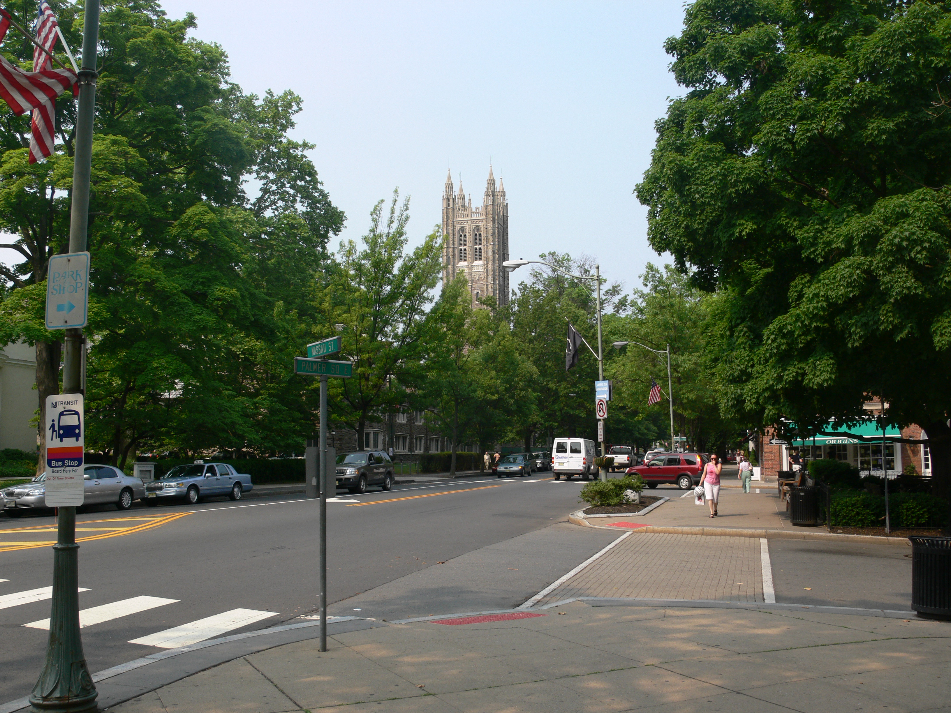
Route 27 begins at a traffic light with U.S. Route 206 and County Route 533 in downtown Princeton Borough, Mercer County. The route heads northeast along Nassau Street, the main street of Princeton that runs along the northern edge of Princeton University and is lined with numerous shops and restaurants.[2] This portion of Route 27 sees between 10,000 and 20,000 cars a day.[1] Just past the beginning of Route 27, County Route 583 heads to the southwest on Mercer Street. Route 27 moves through downtown Princeton, passing by the main gates to Princeton University near Nassau Hall, and intersecting County Route 571 (Washington Road, also signed as County Route 526). After leaving the downtown area, Route 27 continues through residential areas, crossing into Princeton Township where the route becomes Princeton-Kingston Road. Route 27 runs parallel to Carnegie Lake in Princeton Township, then crosses over the Millstone River just north of the historic Kingston Bridge.[1][2]
Middlesex/Somerset County border
Upon crossing the Millstone River, Route 27 runs along the border of Franklin Township, Somerset County to the west and South Brunswick Township, Middlesex County to the east, passing through the historic community of Kingston. It continues northeast through a mix of woodland and residences, intersecting Promenade Boulevard, which heads east and becomes County Route 522 after crossing U.S. Route 1. Route 27 briefly runs entirely into Somerset County before resuming along the Middlesex/Somerset County border. The route continues north to an intersection with County Route 518 (Gateway Boulevard), where it resumes its northeast direction and heads into Kendall Park as a variable two- to four-lane road, entering denser suburban development.[1][2] Route 27 then passes through Franklin Park, intersecting County Route 610 (Henderson Road). Past that intersection, Route 27 forms the border of Franklin Township to the west and North Brunswick Township to the east, passing through suburban development with some areas of farmland, seeing about 38,487 cars a day.[1][2] The road forms the border of Franklin Township and New Brunswick upon intersecting County Route 680 (How Lane) becoming four-lane Somerset Street. Route 27 follows Somerset Street northeast through residential and commercial areas, passing by the community of Somerset on the west side of the road.[1][2]
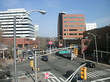 Route 27 at the junction with County Route 527 in New Brunswick
Middlesex County
The route splits from Somerset Street and heads entirely into New Brunswick, Middlesex County along French Street. At the Sandford Street intersection, Route 27 becomes a county-maintained road that is also signed as County Route 644. It then intersects County Route 693 (Jersey Avenue), which heads to the southwest to become Route 91. Past this intersection, the route becomes a two-lane road that heads into downtown New Brunswick, south of the main campus of Rutgers University. Here, the route has a daily traffic count of approximately 11,559 vehicles. It crosses under the Northeast Corridor rail line adjacent to the New Brunswick train station.[1][2] The route turns into a four-lane divided highway and intersects County Route 514 and County Route 527 (Easton Avenue). At this point, County Route 644 ends, with Route 27 forming a concurrency with both county routes 514 and 527, heading east along Albany Street. About 200 yards (180 m) later, the road crosses George Street, which heads to the north as County Route 672 and to the south as Route 171. County Route 527 splits from Albany Street by heading south on Route 171 while Route 27 and County Route 514 continue east, interchanging with Route 18 (Memorial Parkway) a quarter of a mile later. At the Route 18 interchange, Route 27 becomes state-maintained again, crossing the Raritan River on the Albany Street Bridge into Highland Park.[1]
Upon entering Highland Park, Route 27 becomes two-lane Raritan Avenue, intersecting County Route 622 (River Road) and continuing through the downtown area of Highland Park. County Route 514 splits from Route 27 by heading east on Woodbridge Avenue 0.75 mi (1.21 km) later.[1] Route 27 resumes heading northeast past this intersection as a four-lane road that passes by homes, entering Edison Township, where the name changes to Lincoln Highway. The route continues northeast, intersecting County Route 676 (Suttons Lane/Duclos Lane) and County Route 529 (Plainfield Avenue), then travels through a mix of residences and businesses, briefly becoming a divided highway before intersecting Interstate 287 at a partial interchange with access to southbound Interstate 287 and from northbound Interstate 287.[1][2] At this interchange, Route 27 sees approximately 14,386 cars a day.[1] Beyond this interchange, Route 27 crosses into Metuchen and becomes two-lane Essex Avenue, which turns to the east and heads through residential areas.[2] The route turns north onto Lake Street and intersects County Route 501 (Amboy Avenue), forming a concurrency with that route. It passes under the Northeast Corridor and comes to Middlesex Avenue, where County Route 501 turns to the left and Route 27 turns to the right to resume its northeast direction.[1]
Route 27 intersects County Route 531 (Main Street) after 0.2 mi (0.32 km) and continues northeast on Middlesex Avenue, passing through a residential environment where the route carries about 22,414 vehicles daily.[1][2] The route crosses back into Edison Township and becomes the Lincoln Highway again, passing over the Rahway River.[1] It heads through business areas and passes near the Thomas Alva Edison Memorial Tower and Museum, which is located on the site of Thomas Edison's Menlo Park laboratory.[2] The route closely parallels the Northeast Corridor rail line and crosses into Woodbridge Township, widening to four lanes at this point. Route 27 passes by the Metropark train station and interchanges with the Garden State Parkway near Iselin, where approximately 19,780 vehicles travel on Route 27 on a daily basis.[1] Past the Garden State Parkway, Route 27 narrows back to two lanes and continues northeast alongside the Northeast Corridor, passing through a mix of residential and commercial development as a three-lane road with two northbound lanes and one southbound lane.[2]
Union County
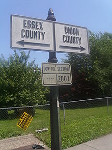 The signage denoting the county line between Essex and Union Counties. This also is the defined line for Newark and Elizabeth
Route 27 crosses into Rahway, Union County and intersects the northern terminus of Route 35. Route 27 continues north using four-lane St. Georges Avenue.[1] The route passes through Rahway, passing by residences and businesses.[2] In Rahway, the route sees about 25,022 cars a day. It continues northeast and crosses into Linden, where the route heads through a more commercial setting with businesses lining both sides of the road. At the intersection with County Route 617 (Wood Avenue), Route 27 forms the border of Roselle to the west and Linden to the east, with about 23,081 vehicles using the road on a daily basis. It passes by Warinaco Park and forms the border between Elizabeth to the west and Linden to the east before entirely entering Elizabeth at the Richford Terrace intersection.[1][2]
In Elizabeth, Route 27 narrows to two lanes and becomes Rahway Avenue, crossing Route 439 and continuing to the northeast through residential and commercial areas. Route 27 splits into a one-way pair with northbound Route 27 following Rahway Avenue east and turning north onto Cherry Street and southbound Route 27 following Westfield Avenue west and turning south onto Chilton Avenue.[1][2] The southbound direction of Route 27 intersects the eastern terminus of Route 28, where that route continues west on Westfield Avenue.[3] Past the one-way pair, Route 27 resumes east on four-lane Westfield Avenue, turning north onto Broad Street. The route heads into a more urbanized setting and continues northeast onto Newark Avenue, intersecting the northern terminus of Route 439. Through Elizabeth, about 10,000 to 20,000 vehicles travel on Route 27 every day.[1]
Essex County
Route 27 crosses into Newark, Essex County at the Virginia Street intersection, where it becomes Frelinghuysen Avenue, a road that heads north through the Dayton neighborhood of Newark, passing through urban areas and by Weequahic Park.[1][2] Route 27 interchanges with U.S. Route 22 and immediately passes under Interstate 78. Route 27 continues north to an intersection with Poinier Street, where the route heads east along that road to its northern terminus at an interchange with Route 21 and Broad Street.[1]
History
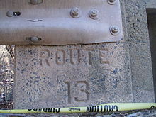 State bridge built in 1919 christened with the former State Highway Route 13 designation assigned in 1917
The southern part of Route 27 follows the Lenape Assunpink Trail that during the colonial era was known as the Old Dutch Trail, and later became the Kings Highway.[4] Route 27 follows portions of several 19th-century turnpikes, including the Essex and Middlesex Turnpike, which was chartered on March 3, 1806 to run from New Brunswick to Newark along what is today Route 27, the Northeast Corridor rail line, and Broad Street in Newark, the Georgetown and Franklin Turnpike, chartered on February 15, 1816 to run from Lambertville to New Brunswick along the present-day alignments of County Route 518 and Route 27, the Newark and Elizabeth Plank Road, chartered on March 14, 1856, and the Princeton and Kingston Branch Turnpike, chartered on December 3, 1807 to run from Trenton to Kingston along current County Route 583 and Route 27.[5] The route became a portion of the Lincoln Highway, the United States' first transcontinental highway that was established in 1913 to run from New York City to San Francisco.[6] It is still known by that name in a few places along the route, particularly in Edison Township.[1] In 1916, the Lincoln Highway was legislated as part of pre-1927 Route 1 between New Brunswick and Elizabeth and as pre-1927 Route 13 between Trenton and New Brunswick in 1917.[7][8] In the 1927 New Jersey state highway renumbering, Route 27 was designated to run from Trenton to the intersection of Frelinghuysen Avenue and Astor Street in Newark, replacing the portions of Routes 1 and 13 that ran along the Lincoln Highway.[9][10] With the creation of the U.S. Highway System, U.S. Route 1 was designated along the length of Route 27 from 1927 until sometime before the 1940s, when the U.S. Route 1 designation was moved to Route 26, Route S26, and Route 25 between Trenton and Newark.[11][12] U.S. Route 206 was designated along the portion of route between Trenton and Princeton by the 1940s.[12] In the 1953 New Jersey state highway renumbering, the southern terminus of Route 27 was cut back to Princeton to avoid the U.S. Route 206 concurrency.[13]
Major intersections
County Location Mile[1] Destinations Notes Mercer Princeton 0.00 US 206 / CR 533 (Bayard Lane/Stockton Street)Southern terminus 0.04  CR 583 south (Mercer Street)
0.40 
 CR 526 east / CR 571 south (Washington Road)
Middlesex South Brunswick Township 4.67  To CR 522 east (Promenade Boulevard)
Somerset Franklin Township 6.90  CR 518 west (Gateway Boulevard)
Middlesex New Brunswick 16.22 
 CR 514 west / CR 527 north (Easton Avenue)
South end of CR 514/CR 527 overlap 16.32 
 Route 171 south / CR 527 south / CR 672 north (George Street)
North end of CR 527 overlap 16.55 Route 18 (Memorial Parkway)Interchange Highland Park 17.48 CR 514 east (Woodbridge Avenue)North end of CR 514 overlap Edison 18.86  CR 529 (Plainfield Avenue)
20.82-20.84 I-287 southI-287 exits 2A-B Metuchen 21.62  CR 501 east (Amboy Avenue)
South end of CR 501 overlap 21.86 CR 501 west (Middlesex Avenue)North end of CR 501 overlap 22.07  CR 531 (Main Street)
Woodbridge 24.69 G.S. Pkwy.GSP exit 131 Union Rahway 27.29 Route 35 south (St. Georges Avenue)Elizabeth 32.98 Route 439 (South Elmora Avenue)34.00 Route 28 west (Westfield Avenue)35.29 Route 439 south (North Avenue)Essex Newark 37.31 US 22Interchange 38.39-38.53 Route 21 (McCarter Highway) / Broad StreetInterchange 1.000 mi = 1.609 km; 1.000 km = 0.621 mi See also
 U.S. Roads portal
 New Jersey portal
References
- ^ a b c d e f g h i j k l m n o p q r s t u v w "Route 27 straight line diagram". New Jersey Department of Transportation. http://www.state.nj.us/transportation/refdata/sldiag/00000027__-.pdf. Retrieved 2008-12-14.
- ^ a b c d e f g h i j k l m n o Google, Inc. Google Maps – overview of New Jersey Route 27 (Map). Cartography by Google, Inc. http://maps.google.com/maps?f=d&saddr=RT-27+%26+Mercer+St,+Princeton,+Mercer,+New+Jersey&daddr=Route+27%2FRT-27+to:RT-27%2FSomerset+St+to:RT-27+to:RT-27%2FSt+George+Ave%2FE+St+Georges+Ave+to:40.688709,-74.20372+to:poinier+street+and+broad+street+newark,+nj&hl=en&geocode=%3BFSCxaAIdouiN-w%3BFbStaQIdvnWP-w%3BFXRGawIdMjaS-w%3BFShQbAIdWj-T-w%3B%3B&mra=dpe&mrcr=0&mrsp=5&sz=12&via=1,2,3,4,5&sll=40.67517,-74.199944&sspn=0.115349,0.219727&ie=UTF8&ll=40.551374,-74.437866&spn=0.462248,0.878906&t=h&z=10. Retrieved 2008-12-14.
- ^ "Route 27 Z straight line diagram". New Jersey Department of Transportation. http://www.state.nj.us/transportation/refdata/sldiag/00000027Z_-.pdf. Retrieved 2008-12-15.
- ^ de Conte, Paul; Dupont, Jr., Ronald, Hiking New Jersey A Guide to 50 of the Garden State's Greatest Hiking Trails, Globe Pequot Press, ISBN 978-0-7627-1119-2, http://books.google.nl/books?id=BspCLoRq1vUC&pg=PA174&lpg=PA174&dq=Assunpink+Trail#v=onepage&q=Assunpink%20Trail&f=false
- ^ Murphy, John L. (1877). Index of Colonial and State Laws Between the Years 1663 and 1877 Inclusive. Google Book Search. http://books.google.com/?id=LVY4AAAAIAAJ. Retrieved 2009-01-13.
- ^ Weingroff, Richard F.. "The Lincoln Highway". Federal Highway Administration. http://www.fhwa.dot.gov/infrastructure/lincoln.htm. Retrieved 2008-12-15.
- ^ Williams, Jimmy and Sharon. "NJ 1920s Route 1". 1920s New Jersey Highways. http://www.jimmyandsharonwilliams.com/njroads/1920s/route01.htm. Retrieved 2008-12-15.
- ^ Williams, Jimmy and Sharon. "NJ 1920s Route 13". 1920s New Jersey Highways. http://www.jimmyandsharonwilliams.com/njroads/1920s/route13.htm. Retrieved 2008-12-15.
- ^ State of New Jersey, Laws of 1927, Chapter 319.
- ^ Williams, Jimmy and Sharon. "1927 New Jersey Road Map". 1920s New Jersey Highways. http://www.jimmyandsharonwilliams.com/njroads/1920s/images/1927_routes.gif. Retrieved 2008-10-08.
- ^ Williams, Jimmy and Sharon. "1927 Tydol Trails Map - South". 1920s New Jersey Highways. http://www.jimmyandsharonwilliams.com/njroads/1920s/maps/1927tt2.jpg. Retrieved 2009-03-30.
- ^ a b Mid-West Map Co. (1941). Map of Pennsylvania and New Jersey (Map). Cartography by H.M. Gousha. http://www.mapsofpa.com/roadcart/1941_1467m.jpg. Retrieved 2009-03-29.
- ^ 1953 renumbering. New Jersey Department of Highways. http://en.wikisource.org/wiki/1953_New_Jersey_state_highway_renumbering. Retrieved July 31, 2009.
External links
Categories:- Transportation in Essex County, New Jersey
- Transportation in Mercer County, New Jersey
- Transportation in Middlesex County, New Jersey
- Transportation in Somerset County, New Jersey
- Transportation in Union County, New Jersey
- State highways in New Jersey
- Lincoln Highway


Wikimedia Foundation. 2010.